|
|
 |
|

|
|
|
Application of U-net model to water extraction with high resolution remote sensing data |
Ning WANG1, Jiahua CHENG2( ), Hanye ZHANG2, Hongjie CAO1,3, Jun LIU3 ), Hanye ZHANG2, Hongjie CAO1,3, Jun LIU3 |
1. Beijing Unistrong Science and Technology Co., Ltd., Beijing 100015, China
2. East China Sea Fisheries Research Institute, Chinese Academy of Fishery Sciences, Shanghai 200090, China
3. BeiDou Navigation and LBS (Beijing) Co., Ltd., Beijing 100191, China |
|
|
|
|
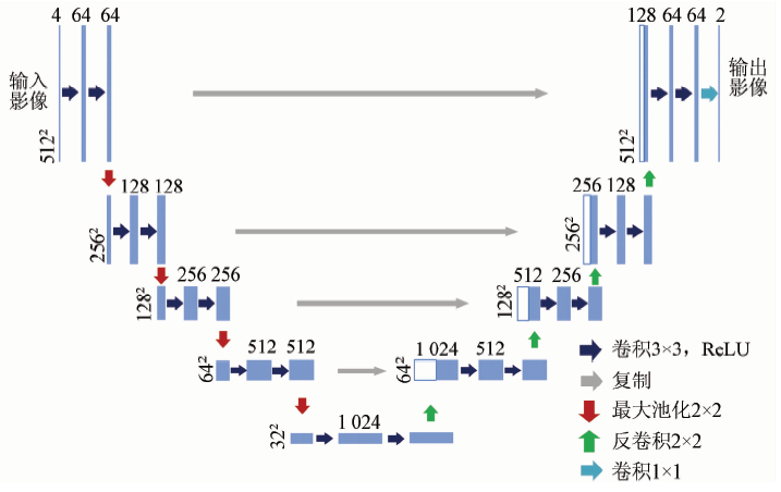
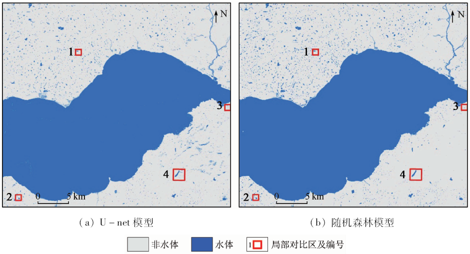
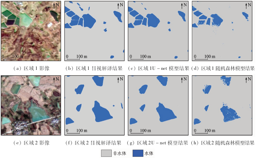
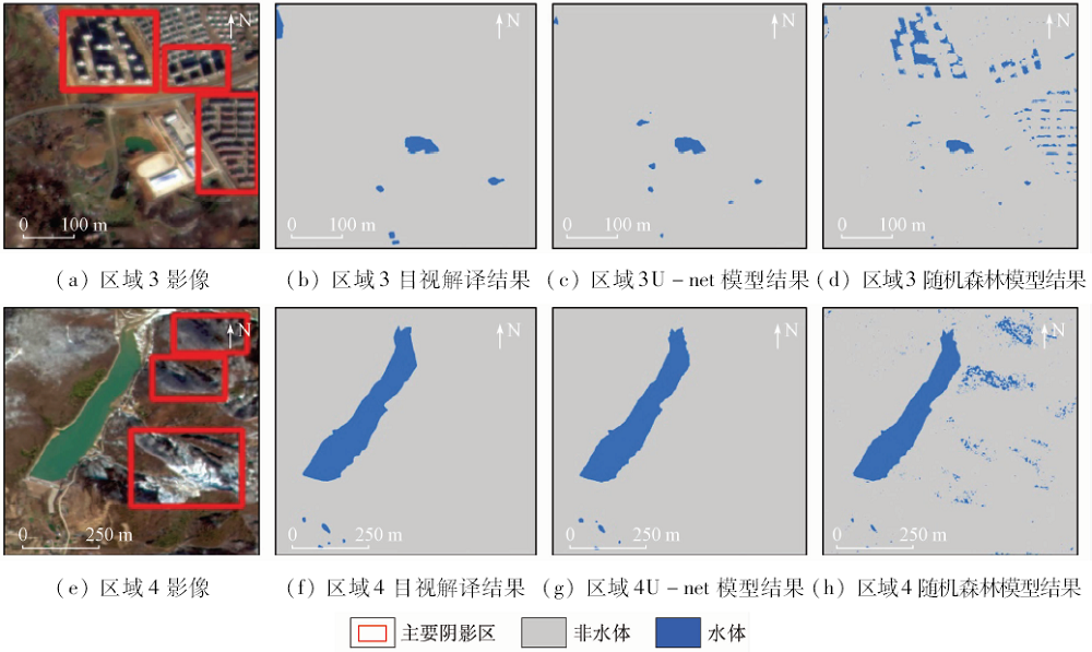
Abstract In this paper, the authors used a U-net model to conduct water extraction, and the result was compared with that of the random forest model. The accuracy of the U-net model was validated by using GF-1 images in Chaohu Lake Basin. The results show that both models are of high accuracy for large area of water body, but random forest model has more spots for small area of water body, and the result of U-net model is more consistent with the manual visual interpretation result. Moreover, the U-net model can effectively remove the shadows of mountains and buildings. The result indicates that U-net model performs better than random forest model with the overall accuracy of 98.69%, Kappa coefficient of 0.95, omission error of 1.90% and commission error of 1.18%. In contrast, the overall accuracy, Kappa coefficient, omission error and commission error of random forest model are about 98.05%, 0.92, 1.61% and 2.99%, respectively. In addition, the classification features for traditional machine learning model are always calculated by manual extraction. However, the inputs for U-net model are the 4 band spectrum data of GF-1 images. These data suggest that the U-net model avoids the process of manually extracting classification features and has a higher degree of automation. It should be noted that the U-net model uses more train samples with less time-consuming. It is believed that this model can significantly improve the surface water detection accuracy and can be used for the automatic renewal of a larger range of water bodies.
|
| Keywords
GF-1
U-net
random forest
water extraction
|
|
|
|
Corresponding Authors:
Jiahua CHENG
E-mail: dhsziyuan@163.com
|
|
Issue Date: 14 March 2020
|
|
|
| [1] |
Pekel J, Cottam A, Gorelick N , et al. High-resolution mapping of global surface water and its long-term changes[J]. Nature, 2016,540(7633):418-422.
|
| [2] |
Khandelwal A, Karpatne A, Marlier M E , et al. An approach for global monitoring of surface water extent variations in reservoirs using MODIS data[J]. Remote Sensing of Environment, 2017,202:113-128.
|
| [3] |
Rao P Z, Jiang W G, Hou Y K , et al. Dynamic change analysis of surface water in the Yangtze River Basin based on MODIS products[J]. Remote Sensing, 2018,10(7):1025.
|
| [4] |
Wang Z F, Liu J G, Li J B , et al. Multi-spectral water index (MuWI):A native 10-m multi-spectral water index for accurate water mapping on Sentinel-2[J]. Remote Sensing, 2018,10(10):1643.
|
| [5] |
Yao F F, Wang C, Dong D , et al. High-resolution mapping of urban surface water using ZY-3 multi-spectral imagery[J]. Remote Sensing, 2015,7(9):12336-12355.
|
| [6] |
Yang F, Guo J, Tan H , et al. Automated extraction of urban water bodies from ZY-3 multi-spectral imagery[J]. Water, 2017,9(2):144.
|
| [7] |
陈文倩, 丁建丽, 李艳华 , 等. 基于国产GF-1遥感影像的水体提取方法[J]. 资源科学, 2015,37(6):1166-1172.
|
| [7] |
Chen W Q, Ding J L, Li Y H , et al. Extraction of water information based on China-made GF-1 remote sense image[J]. Resources Science, 2015,37(6):1166-1172.
|
| [8] |
王瑾杰, 丁建丽, 张成 , 等. 基于GF-1卫星影像的改进SWI水体提取方法[J]. 国土资源遥感, 2017,29(1):29-35.doi: 10.6046/gtzyyg.2017.01.05.
|
| [8] |
Wang J J, Ding J L, Zhang C , et al. Method of water information extraction by improve SWI based on GF-1 satellite image[J]. Remote Sensing for Land and Resources, 2017,29(1):29-35.doi: 10.6046/gtzyyg.2017.01.05.
|
| [9] |
毕海云, 王思远, 曾江源 , 等. 基于TM影像的几种常用水体提取方法的比较和分析[J]. 遥感信息, 2012,27(5):77-82
|
| [9] |
Bi H Y, Wang S Y, Zeng J Y , et al. Comparison and analysis of several common water extraction methods based on TM image[J]. Remote Sensing Information, 2012,27(5):77-82
|
| [10] |
Mcfeeters S K . The use of the normalized difference water index (NDWI) in the delineation of open water features[J]. International Journal of Remote Sensing, 1996,17(7):1425-1432.
|
| [11] |
Xu H Q . Modification of normalized difference water index (NDWI) to enhance open water features in remotely sensed imagery[J]. International Journal of Remote Sensing, 2006,27(14):3025-3033.
|
| [12] |
Ogilvie A, Belaud G, Massuel S , et al. Surface water monitoring in small water bodies:Potential and limits of multi-sensor Landsat time series[J]. Hydrology and Earth System Sciences, 2018,22(8):1-35.
|
| [13] |
Fisher A, Danaher T . A water index for SPOT5 HRG satellite imagery,New South Wales,Australia,determined by linear discriminant analysis[J]. Remote Sensing, 2013,5(11):5907-5925.
|
| [14] |
Feyisa G L, Meilby H, Fensholt R , et al. Automated water extraction index:A new technique for surface water mapping using Landsat imagery[J]. Remote Sensing of Environment, 2014,140(1):23-35.
|
| [15] |
Wang S D, Baig M H A, Zhang L F , et al. A simple enhanced water index (EWI) for percent surface water estimation using Landsat data[J]. IEEE Journal of Selected Topics in Applied Earth Observations and Remote Sensing, 2015,8(1):90-97.
|
| [16] |
Guo Q D, Pu R L, Li J L , et al. A weighted normalized difference water index for water extraction using Landsat imagery[J]. International Journal of Remote Sensing, 2017,38(19):5430-5445.
|
| [17] |
刁淑娟, 刘春玲, 张涛 , 等. 基于SVM的湖泊咸度等级遥感信息提取方法——以内蒙古巴丹吉林沙漠为例[J]. 国土资源遥感, 2016,28(4):114-118.doi: 10.6046/gtzyyg.2016.04.18.
|
| [17] |
Diao S J, Liu C L, Zhang T , et al. Extraction of remote sensing information for lake salinity level based on SVM:A case from Badain Jaran desert in Inner Mongolia[J]. Remote Sensing for Land and Resources, 2016,28(4):114-118.doi: 10.6046/gtzyyg.2016.04.18.
|
| [18] |
Feng Q L, Liu J T, Gong J H . Urban flood mapping based on unmanned aerial vehicle remote sensing and random forest classifier:A case of Yuyao,China[J]. Water, 2015,7:1437-1455.
|
| [19] |
Badrinarayanan V, Kendall A, Cipolla R . SegNet:A deep convolutional encoder-decoder architecture for image segmentation[EB/OL]. (2015-11-02). https://arxiv.org/abs/1511.00561.
url: https://arxiv.org/abs/1511.00561
|
| [20] |
Noh H, Hong S, Han B . Learning deconvolution network for semantic segmentation[C]// IEEE International Conference on Computer Vision.Santiago:IEEE, 2015: 1520-1528.
|
| [21] |
Chen L C, Papandreou G, Kokkinos I , et al. DeepLab:Semantic image segmentation with deep convolutional nets,atrous convolution,and fully connected CRFs[J]. IEEE Transactions on Pattern Analysis and Machine Intelligence, 2016,40(4):834-848.
|
| [22] |
Ronneberger O, Fischer P, Brox T . U-Net:Convolutional networks for biomedical image segmentation[C]// International Conference on Medical Image Computing and Computer-Assisted Intervention.Cham:Springer, 2015: 234-241.
|
| [23] |
伍广明, 陈奇, Shibasaki R , 等. 基于U型卷积神经网络的航空影像建筑物检测[J]. 测绘学报, 2018,47(6):864-872.
|
| [23] |
Wu G M, Chen Q, Shibasaki R , et al. High precision building detection from aerial imagery using a U-Net like convolutional architecture[J]. Acta Geodaetica et Cartographica Sinica, 2018,47(6):864-872.
|
| [24] |
苏健民, 杨岚心, 景维鹏 . 基于U-Net的高分辨率遥感图像语义分割方法[J]. 计算机工程与应用, 2019,55(7):207-213.
|
| [24] |
Su J M, Yang L X, Jing W P . A U-Net based semantic segmentation method for high resolution remote sensing image[J]. Computer Engineering and Applications, 2019,55(7):207-213.
|
| [25] |
Breiman L . Random forests[J]. Machine Learning, 2001,45(1):5-32.
|
| [26] |
陈辰, 周拥军, 李元祥 , 等. 基于U-net分割和HEIV模型的遥感图像配准方法[EB/OL]. (2018-11-30). https://kns.cnki.net/KCMS/detail/31.1289.tp.20181129.1323.005.html.
url: https://kns.cnki.net/KCMS/detail/31.1289.tp.20181129.1323.005.html
|
| [26] |
Chen C, Zhou Y J, Li Y X , et al. Remote sensing image registration based on U-net segmentation and the HEIV model[EB/OL]. (2018-11-30). https://kns.cnki.net/KCMS/detail/31.1289.tp.20181129.1323.005.html.
url: https://kns.cnki.net/KCMS/detail/31.1289.tp.20181129.1323.005.html
|
| [27] |
李炳亚, 潘剑君, 夏超 , 等. 基于空间位置关系的山地湖泊水体提取方法研究[J]. 遥感技术与应用, 2016,31(5):983-993.
|
| [27] |
Li B Y, Pan J J, Xia C , et al. Study on the extraction method of lake water body in mountainous based on spatial position relation[J]. Remote Sensing Technology and Application, 2016,31(5):983-993.
|
|
Viewed |
|
|
|
Full text
|
|
|
|
|
Abstract
|
|
|
|
|
Cited |
|
|
|
|
| |
Shared |
|
|
|
|
| |
Discussed |
|
|
|
|
 2020,
Vol. 32
2020,
Vol. 32