|
|
 |
|

|
|
|
An improved method for extracting alteration related to the ductile shear zone type gold deposits using ASTER data |
Jianyu LIU1,2, Ling CHEN2( ), Wei LI2, Genhou WANG1, Bo WANG1 ), Wei LI2, Genhou WANG1, Bo WANG1 |
1.School of Earth Science and Resources, China University of Geosciences(Beijing), Beijing 100083, China
2.China Aero Geophysical Survey and Remote Sensing Center for Natural Resources, Beijing 100083, China |
|
|
|
|
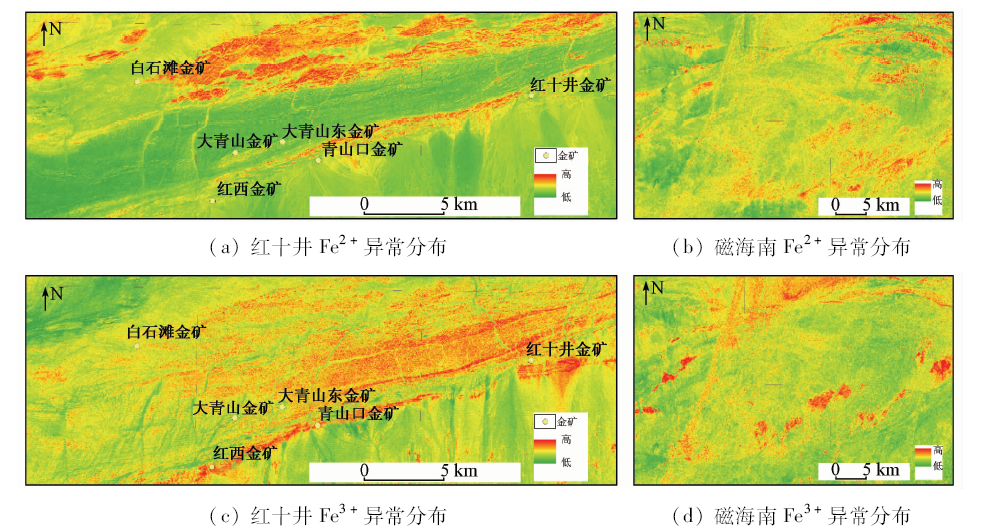
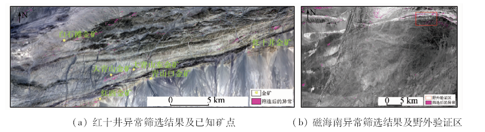
Abstract The Beishan rift is an important metallic zone in China. The principal analysis component (PCA) technique and band ratio were used to extract alteration information related to gold deposits in the study areas in Hongshijing region and south of Cihai region lying in the west of Beishan rift. As a result of regional metamorphism, the alteration zones extracted by PCA and band ratios contain a great deal of interference information. With the method proposed in this study, most useless alteration information was eliminated and the gold deposits were located at or near the selected alteration areas in Hongshijing region. To prove the capability of this method, the authors validated the selected alteration areas south of Cihai region by fieldwork and found two gold ore spots. It is concluded that this method is effective in eliminating useless alteration information and thus is recommended for application in similar geological settings in Beishan rift.
|
| Keywords
ASTER data
Beishan rift
selection of alteration zone
gold deposit
|
|
|
|
Corresponding Authors:
Ling CHEN
E-mail: chenling010@126.com
|
|
Issue Date: 14 March 2019
|
|
|
| [1] |
Xiao W J, Zhang L C, Qin K Z , et al. Paleozoic accretionary and collisional tectonics of the eastern Tianshan (China):Implications for the continental growth of central Asia[J]. American Journal of Science, 2004,304(4):370-395.
doi: 10.1144/0016-764903-165
url: http://www.ajsonline.org/cgi/doi/10.2475/ajs.304.4.370
|
| [2] |
Xiao W J, Mao Q G, Windley B F , et al. Paleozoic multiple accretionary and collisional processes of the Beishan orogenic collage[J]. American Journal of Science, 2010,310(10):1553-1594.
doi: 10.2475/10.2010.12]
url: http://www.ajsonline.org/cgi/doi/10.2475/10.2010.12
|
| [3] |
丁建华, 邢树文, 肖克炎 , 等. 东天山—北山Cu-Ni-Au-Pb-Zn成矿带主要成矿地质特征及潜力分析[J]. 地质学报, 2016,90(7):1392-1412.
doi: 10.3969/j.issn.0001-5717.2016.07.010
url: http://www.cnki.com.cn/Article/CJFDTotal-DZXE201607009.htm
|
| [3] |
Ding J H, Xing S W, Xiao K Y , et al. Geological characteristics and resource potential analysis of the Dongtianshan-Beishan Cu-Ni-Au-Pb-Zn metallogenic belts[J]. Acta Geologica Sinica, 2016,90(7):1392-1412.
|
| [4] |
Chen B L, Wu G G, Ye D J , et al. Analysis of the ore-controlling structure of ductile shear zone type gold deposit in southern Beishan Area,Gansu,Northwest China[J]. Journal of China University of Geosciences, 2007,18(1):30-38.
doi: 10.1016/S1002-0705(07)60016-8
url: https://linkinghub.elsevier.com/retrieve/pii/S1002070507600168
|
| [5] |
陈柏林, 吴淦国, 叶德金 . 北山地区金矿床金的赋存状态和金矿物特征[J]. 矿物学报, 2000,20(3):242-249.
doi: 10.3321/j.issn:1000-4734.2000.03.006
url: http://d.wanfangdata.com.cn/Periodical/kwxb200003006
|
| [5] |
Chen B L, Wu G G, Ye D J , et al. Mode of occurrence of gold and characteristics of gold minerals in gold deposits,Beishan Area,Gansu[J]. Acta Mineralogica Sinica, 2000,20(3):242-249.
|
| [6] |
王兆洲, 安国堡 . 甘肃北山南带西段金成矿带控矿因素及成矿预测[J]. 新疆地质, 2007,25(3):307-312.
doi: 10.3969/j.issn.1000-8845.2007.03.017
url: http://d.wanfangdata.com.cn/Periodical_xjdz200703017.aspx
|
| [6] |
Wang Z Z, An G B . Ore controlling factors and minerogenic prognosis of western metallogenic belt of south belt of Beishan,Gansu[J]. Xinjiang Geology, 2007,25(3):307-312.
|
| [7] |
陈柏林 . 甘新北山金窝子韧性剪切带型金矿床成因[J]. 矿床地质, 2010. 29(6):972-982.
doi: 10.3969/j.issn.0258-7106.2010.06.003
url: http://www.cnki.com.cn/Article/CJFDTotal-KCDZ201006002.htm
|
| [7] |
Chen B L . A discussion on origin of Jinwozi ductile shear zone type gold deposit in Beishan Area of Gansu and Xinjiang[J]. Mineral Deposits, 2010,29(6):972-982.
|
| [8] |
肖惠良, 周济元, 王鹤年 , 等. 新疆红十井金矿床特征及成因[J]. 矿床地质, 2003,22(1):32-40.
doi: 10.3969/j.issn.0258-7106.2003.01.004
url: http://d.wanfangdata.com.cn/Periodical/kcdz200301004
|
| [8] |
Xiao H L, Zhou J Y, Wang H N , et al. Characteristics and genesis of Hongshijing gold deposit,Xinjiang[J]. Mineral Deposits, 2003,22(1):32-40.
|
| [9] |
何格, 顾雪祥, 章永梅 , 等. 新疆北山地区大青山金矿床地质特征及成因初探[J]. 矿床地质. 2014,33(s1):89-90
url: 研究点分析
|
| [9] |
He G, Gu X X, Zhang Y M , et al. Geological characteristics and genesis of Daqingshan gold deposit in Beishan Area,Xinjiang[J]. Mineral Deposits. 2014,33(s1):89-90.
|
| [10] |
Loughlin W P . Principal component analysis for alteration mapping[J]. Photogrammetric Engineering and Remote Sensing, 1991,57(9):1163-1169.
|
| [11] |
Crosta A P, De Souza Filho C R, Azevedo F, et al. Targeting key alteration minerals in epithermal deposits in Patagonia,Argentina,using ASTER imagery and principal component analysis[J]. International Journal of Remote sensing, 2003,24(21):4233-4240.
doi: 10.1080/0143116031000152291
url: https://www.tandfonline.com/doi/full/10.1080/0143116031000152291
|
| [12] |
Gabr S, Ghulam A, Kusky T . Detecting areas of high-potential gold mineralization using ASTER data[J]. Ore Geology Reviews, 2010,38(1-2):59-69.
doi: 10.1016/j.oregeorev.2010.05.007
url: https://linkinghub.elsevier.com/retrieve/pii/S0169136810000600
|
| [13] |
Pournamdari M, Hashim M . Detection of chromite bearing mineralized zones in Abdasht ophiolite complex using ASTER and ETM+ remote sensing data[J]. Arabian Journal of Geosciences, 2014,7(5):1973-1983.
doi: 10.1007/s12517-013-0927-0
url: http://link.springer.com/10.1007/s12517-013-0927-0
|
| [14] |
Rajendran S, Nasir S, Kusky T M , et al. Detection of hydrothermal mineralized zones associated with listwaenites in central Oman using ASTER data[J]. Ore Geology Reviews, 2013,53(8):470-488.
doi: 10.1016/j.oregeorev.2013.02.008
url: https://linkinghub.elsevier.com/retrieve/pii/S0169136813000516
|
| [15] |
Azizi H, Tarverdi M A, Akbarpour A . Extraction of hydrothermal alterations from ASTER SWIR data from east Zanjan,northern Iran[J]. Advances in Space Research, 2010,46(1):99-109.
doi: 10.1016/j.asr.2010.03.014
url: https://linkinghub.elsevier.com/retrieve/pii/S0273117710001857
|
| [16] |
Zhang X, Pazner M, Duke N . Lithologic and mineral information extraction for gold exploration using ASTER data in the south Chocolate Mountains (California)[J]. ISPRS Journal of Photogrammetry and Remote Sensing, 2007,62(4):271-282.
doi: 10.1016/j.isprsjprs.2007.04.004
url: https://linkinghub.elsevier.com/retrieve/pii/S0924271607000287
|
| [17] |
王頔, 赵志芳, 王瑞雪 , 等. 遥感矿化蚀变分带弱信息增强提取方法研究——以普朗斑岩型铜矿区为例[J]. 国土资源遥感, 2015,27(2):146-153.doi: 10.6046/gtzyyg.2015.02.23.
doi: 10.6046/gtzyyg.2015.02.23
url: http://www.cnki.com.cn/Article/CJFDTotal-GTYG201502023.htm
|
| [17] |
Wang D, Zhao Z F, Wang R X , et al. Research on enhanced extraction method for weak information of remote sensing mineralization alteration zoning:A case study of the Pulang porphyry copper deposit[J]. Remote Sensing for Land and Resources, 2015,27(2):146-153.doi: 10.6046/gtzyyg.2015.02.23.
|
| [18] |
成功, 朱佳玮, 毛先成 . 基于ASTER数据的金川铜镍矿床外围遥感找矿预测[J]. 国土资源遥感, 2016,28(1):15-21.doi: 10.6046/gtzyyg.2016.01.03.
doi: 10.6046/gtzyyg.2016.01.03
|
| [18] |
Cheng G, Zhu J W, Mao X C . Remote sensing prospecting prediction in periphery of the Jinchuan copper-nickel deposit based on ASTER data[J]. Remote Sensing for Land and Resources, 2016,28(1):15-21.doi: 10.6046/gtzyyg.2016.01.03.
|
| [19] |
杨金中, 陈薇, 王辉 . 西昆仑成矿带黑恰达坂温泉沟群含铁层位的圈定[J]. 国土资源遥感, 2017,29(3):191-195.doi: 10.6046/gtzyyg.2017.03.28.
doi: 10.6046/gtzyyg.2017.03.28
url: http://www.cnki.com.cn/Article/CJFDTotal-GTYG201703028.htm
|
| [19] |
Yang J Z, Chen W, Wang H , et al. Delineation of iron formation in Wenquangou Group along Heiqia Pass in West Kunlun metallogenic belt[J]. Remote Sensing for Land and Resources, 2017,29(3):191-195.doi: 10.6046/gtzyyg.2017.03.28.
|
| [20] |
张玉君, 曾朝铭, 陈薇 . ETM+(TM)蚀变遥感异常提取方法研究与应用——方法选择和技术流程[J]. 国土资源遥感, 2003,15(2):44-49.doi: 10.6046/gtzyyg.2003.02.11.
doi: 10.3969/j.issn.1001-070X.2003.02.011
url: http://www.cqvip.com/Main/Detail.aspx?id=10271899
|
| [20] |
Zhang Y J, Zeng Z M, Chen W . The methods for extraction of alteration anomalies from the ETM+(TM) data and their application:Method selection and technological flow chart[J]. Remote Sensing for Land and Resources, 2003,15(2):44-49.doi: 10.6046/gtzyyg.2003.02.11.
|
| [21] |
张楠楠, 周可法, 陈曦 , 等. 基于ETM+的遥感蚀变信息提取方法对比研究[J]. 国土资源遥感, 2012,24(2):34-40.doi: 10.6046/gtzyyg.2012.02.07.
doi: 10.6046/gtzyyg.2012.02.07
url: http://d.wanfangdata.com.cn/Periodical/gtzyyg201202007
|
| [21] |
Zhang N N, Zhou K F, Chen X , et al. A comparative study of extraction methods for alteration information based on ETM+[J]. Remote Sensing for Land and Resources, 2012,24(2):34-40.doi: 10.6046/gtzyyg.2012.02.07.
|
| [22] |
张志军, 甘甫平, 李贤庆 , 等. 基于ASTER数据的蚀变矿物信息提取——以哈密黄山铜镍矿区为例[J]. 国土资源遥感, 2012,24(2):85-91.doi: 10.6046/gtzyyg.2012.02.16.
doi: 10.6046/gtzyyg.2012.02.16
url: http://www.cqvip.com/QK/91397X/201202/42037727.html
|
| [22] |
Zhang Z J, Gan F P, Li X Q , et al. The extraction of altered mineral information based on ASTER data:A case study of the Huangshan copper-nickel ore district in Hami[J]. Remote Sensing for Land and Resources, 2012,24(2):85-91.doi: 10.6046/gtzyyg.2012.02.16.
|
| [23] |
范素英 . 层次分析法在冀北地区多金属矿找矿预测中的应用[J]. 国土资源遥感, 2017,29(2):125-131.doi: 10.6046/gtzyyg.2017.02.18.
doi: 10.6046/gtzyyg.2017.02.18
url: http://d.wanfangdata.com.cn/Periodical/gtzyyg201702018
|
| [23] |
Fan S Y . Application of analytic hierarchy process method to ore-prospecting prognosis in northern Hebei[J]. Remote Sensing for Land and Resources, 2017,29(2):125-131.doi: 10.6046/gtzyyg.2017.02.18.
|
| [24] |
新疆地质矿产局. 白山幅1/20万区域地质调查报告[R]. 1979.
|
| [24] |
Xinjiang Bureau of Geology and Mineral Resources. The Report of Regional Geology Survey in Baishan Region (1:200,000)[R]. 1979.
|
| [25] |
新疆地质矿产局. 库木库都克幅1/20万区域地质调查报告[R]. 1990.
|
| [25] |
Xinjiang Bureau of Geology and Mineral Resources. The Report of Regional Geology Survey in Kumukuke Region (1:200,000)[R]. 1990.
|
| [26] |
陈柏林, 杨农, 吴淦国 , 等. 甘肃北山南带韧性剪切带型金矿床构造控矿解析[J]. 矿床地质, 2002,21(2):149-158.
doi: 10.3969/j.issn.0258-7106.2002.02.007
url: http://www.cqvip.com/QK/93610X/200202/6221771.html
|
| [26] |
Chen B L, Yang N, Wu G G , et al. Analysis of ore-controlling structure in ductile shear zone type gold deposits in southern Beishan Area,Gansu Province[J]. Mineral Deposits, 2002,21(2):149-158.
|
| [27] |
陈柏林, 吴淦国, 杨农 , 等. 甘肃北山白墩子—小西弓韧性剪切带及其控矿作用[J]. 地质力学学报, 2007,13(2):99-109.
doi: 10.3969/j.issn.1006-6616.2007.02.003
url: http://www.cqvip.com/Main/Detail.aspx?id=25252811
|
| [27] |
Chen B L, Wu G G, Yang N , et al. Baidunzi-Xiaoxugong ductile shear zone and its ore-controlling effect in the southern Beishan Area, Gansu[J]. Journal of Geomechanics, 2007,13(2):99-109.
|
| [28] |
王军 . 甘肃北山南带韧性剪切带型金矿床(点)地质特征及找矿方向[J]. 地质找矿论丛, 2005,20(z1):33-35,39.
doi: 10.3969/j.issn.1001-1412.2005.z1.008
url: http://d.wanfangdata.com.cn/Periodical/dzzklc2005z1008
|
| [28] |
Wang J . Geological characteristics of ductile shearing zone type Au deposits and ore-seaching direction in the south belt, Beishan Region,Gansu Province[J]. Contributions to Geology and Mineral Resources. 2005,20(z1):33-35,39.
|
| [29] |
Kalinowski A, Oliver S . ASTER Mineral Index Processing Manual[R].Remote Sensing Applications. Geoscience Australia, 2004.
|
| [30] |
Lowell J D, Guilbert J M . Lateral and vertical alteration-mineralization zoning in porphyry ore deposits[J]. Economic Geology, 1970,65(4):373-408.
doi: 10.2113/gsecongeo.65.4.373
url: http://pubs.geoscienceworld.org/economicgeology/article/65/4/373/18036/Lateral-and-vertical-alterationmineralization
|
| [31] |
Mars J C, Rowan L C . Regional mapping of phyllic-and argillic-altered rocks in the Zagros magmatic arc,Iran,using advanced spaceborne thermal emission and reflection radiometer (ASTER) data and logical operator algorithms[J]. Geosphere, 2006,2(3):161-186.
doi: 10.1130/GES00044.1
url: https://pubs.geoscienceworld.org/geosphere/article/2/3/161-186/31132
|
| [32] |
Zhang T B, Yi G H, Li H M , et al. Integrating data of ASTER and Landsat-8 OLI (AO) for hydrothermal alteration mineral mapping in Duolong porphyry Cu-Au deposit,Tibetan Plateau,China[J]. Remote Sensing, 2016,8(11):890.
doi: 10.3390/rs8110890
url: http://www.mdpi.com/2072-4292/8/11/890
|
| [33] |
王辉, 范玉海, 张少鹏 , 等. 运用高分遥感技术圈定西昆仑黑恰铁多金属矿化带[J]. 中国地质调查, 2016,3(5):13-20.
url: http://www.cqvip.com/QK/72008X/201605/670322487.html
|
| [33] |
Wang H, Fan Y H, Zhang S P , et al. Delineation of Heiqia iron polymetallic mineralization zone in West Kunlun Region using high resolution remote sensing technology[J]. Geological Survey of China, 2016,3(5):13-20.
|
| [34] |
易欢, 李健强, 韩海辉 , 等. 遥感技术在阿尔金贝壳滩地区矿产资源综合调查中的应用[J]. 中国地质调查, 2016,3(4):1-5.
url: http://d.wanfangdata.com.cn/Periodical/zgdzdc201604001
|
| [34] |
Yi H, Li J Q, Han H H , et al. Application of remote sensing in integrated survey on mineral exploration in Beketan,Altyn[J]. Geological Survey of China, 2016,3(4):1-5.
|
| [35] |
杨金中, 王海庆, 陈微 . 西昆仑成矿带高分辨率遥感调查主要进展与成果[J]. 中国地质调查, 2016,3(5):7-12.
url: http://d.wanfangdata.com.cn/Periodical/zgdzdc201605002
|
| [35] |
Yang J Z, Wang H Q, Chen W . Main progress and achievements of high spacial resolution remote sensing survey on west Kunlun metallorgenic belt[J]. Geological Survey of China, 2016,3(5):7-12.
|
| [36] |
闫柏琨, 董新丰, 王喆 , 等. 航空高光谱遥感矿物信息提取技术及其应用进展——以中国西部成矿带调查为例[J]. 中国地质调查, 2016,3(4):55-62.
url: http://www.cnki.com.cn/Article/CJFDTotal-DZDC201604009.htm
|
| [36] |
Yan B K, Dong X F, Wang Z , et al. Mineral information extraction technology by airborne hyperspectral remote sensing and its application progress:An example of mineralization belts of western China[J]. Geological Survey of China, 2016,3(4):55-62.
|
|
Viewed |
|
|
|
Full text
|
|
|
|
|
Abstract
|
|
|
|
|
Cited |
|
|
|
|
| |
Shared |
|
|
|
|
| |
Discussed |
|
|
|
|
 2019,
Vol. 31
2019,
Vol. 31