|
|
 |
|

|
|
|
Geological disaster hazard assessment in Yanchi County based on AHP |
Xiaodong ZHANG1,2, Xiangnan LIU1( ), Zhipeng ZHAO2, Dan WU3,4, Wenzhong WU2, Xiaodong CHU2 ), Zhipeng ZHAO2, Dan WU3,4, Wenzhong WU2, Xiaodong CHU2 |
1. School of Information Engineering, China University of Geosciences(Beijing), Beijing 100083, China
2. Ningxia Geological Survey Institute, Yinchuan 750021, China
3. College of Resources and Environmental Science, Ningxia University, Yinchuan 750021, China
4. Ningxia Institute of Remote Sensing Survey and Mapping(Ningxia Remote Sensing Center), Yinchuan 750021, China |
|
|
|
|
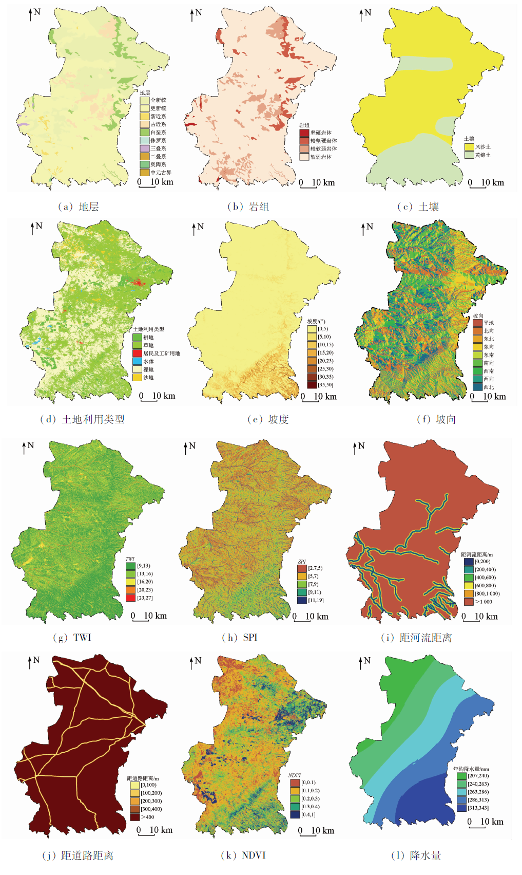
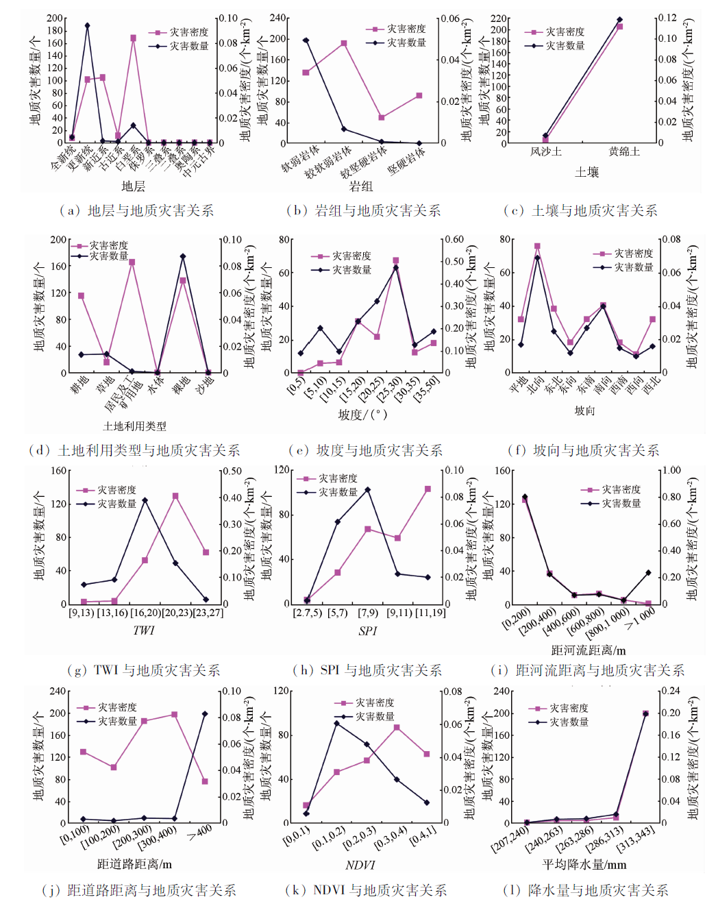
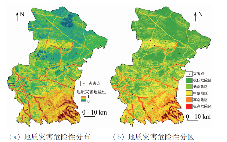
Abstract In order to discuss the regional hazard assessment method of geological disaster, the authors, based on the comprehensive study of hazard-formative environments of Yanchi County, extracted twelve conditioning factors, i.e., strata, lithology, soil, land use type, slope, aspect, topographic wetness index (TWI), stream power index (SPI), distance to river, distance to road, normalized difference vegetation index (NDVI) and precipitation in the evaluation and information of factors by employing GIS with remote sensing data and geological data. Then the judgment matrix of conditioning factors and factor classes were constructed by analytic hierarchy process (AHP) method, and geological disaster hazard index (GDHI) was built. Finally the geological disaster hazard of Yanchi County was assessed and the resulted hazard map was classified into five classes, including very low, low, moderate, high and very high hazard. Meanwhile validation of the hazard map was performed using success rate curve and receiver operating characteristics (ROC) technique. The results are as follows: ①The area percentage of very low and low class accounts for 34% and 28% respectively, mainly distributed among the middle and north of hill region; the area percentage of moderate class accounts for 25%, mainly distributed in the area of Mahuang Mountain, western Wanglejing and two sides of the main roads; the area percentage of high and very high class accounts for 12% and 1% respectively, mainly distributed in the area on two sides of rivers and Mahuang Mountain. ②The area under curve (AUC) value of success rate curve and ROC is 0.77 and 0.89 respectively, which shows a reasonable validation accuracy of hazard assessment. At the same time, disaster density shows the characteristics of a continuing increase in the density values from the very low class to the very high class, and the density of the very high hazard class has maximum value with 1.076/km 2. ③AHP method was successfully used to assess the geological disaster hazard of Yanchi County and AHP is suitable for hazard mapping in this region. The evaluation results could provide a reference for the prevention and control of geological disasters in Yanchi County.
|
| Keywords
geological hazard
hazard assessment
analytic hierarchy process(AHP)
Yanchi County
|
|
|
|
Corresponding Authors:
Xiangnan LIU
E-mail: liuxn@cugb.edu.cn
|
|
Issue Date: 30 August 2019
|
|
|
| [1] |
张春山, 张业成, 张立海 . 中国崩塌、滑坡、泥石流灾害危险性评价[J]. 地质力学学报, 2004,10(1):27-32.
|
| [1] |
Zhang C S, Zhang Y C, Zhang L H . Danger assessment of collapses,landslides and debris flows of geological hazards in China[J]. Journal of Geomechanics, 2004,10(1):27-32.
|
| [2] |
Wang H B, Sassa K . Comparative evaluation of landslide susceptibility in Minamata area,Japan[J]. Environmental Geology, 2005,47(7):956-966.
|
| [3] |
Saaty T L . The Analytic Hierarchy Process:Planning, Priority Setting,Resource Allocation[M]. New York:McGraw-Hill, 1980.
|
| [4] |
姚玉增, 任群智, 李仁峰 , 等. 层次分析法在山地地质灾害危险性评价中的应用——以辽宁凌源地区为例[J]. 水文地质工程地质, 2010,37(2):130-134.
|
| [4] |
Yao Y Z, Ren Q Z, Li R F , et al. Application of analytic hierarchy process to the probability assessment of mountain geological disasters:A case study of Lingyuan region,Liaoning Province[J]. Hydrogeology and Engineering Geology, 2010,37(2):130-134.
|
| [5] |
常青, 刘琳, 苗利勇 . 基于模糊综合评判法临潼区地质灾害危险性评价[J]. 中国人口·资源与环境, 2014,24(3):355-358.
|
| [5] |
Chang Q, Liu L, Miao L Y . Geological hazard risk assessment based on fuzzy mathematics in Lintong[J]. China Population,Resources and Environment, 2014,24(3):355-358.
|
| [6] |
李健强, 韩海辉, 高婷 , 等. 资源三号卫星在地质灾害调查评价中的应用——以宝鸡黄土区为例[J]. 国土资源遥感, 2017,29(s1):73-80.doi: 10.6046/gtzyyg.2017.s1.12.
|
| [6] |
Li J Q, Han H H, Gao T , et al. The application of ZY-3 satellite to geological hazards survey and evaluation:A case study of Baoji loess area[J]. Remote Sensing for Land and Resources, 2017,29(s1):73-80.doi: 10.6046/gtzyyg.2017.s1.12.
|
| [7] |
李晓璇, 马海建 . 基于Logistic模型的地震次生崩滑危险性评价——以汶川县为例[J]. 地震, 2013,33(2):63-70.
|
| [7] |
Li X X, Ma H J . Risk assessment of earthquke-induced collapses and slides based on Logistic model for the case of Wenchuan County[J]. Earthquake, 2013,33(2):63-70.
|
| [8] |
张重, 沈晓华, 邹乐君 , 等. 滑坡危险性评价模型中的量化方式研究——以永嘉县为例[J]. 国土资源遥感, 2010,22(3):16-20.doi: 10.6046/gtzyyg.2010.03.04.
doi: 10.6046/gtzyyg.2010.03.04
|
| [8] |
Zhang Z, Shen X H, Zou L J , et al. The quantification method in the estimation model for landslide danger:A case study of Yongjia County[J]. Remote Sensing for Land and Resources, 2010,22(3):16-20.doi: 10.6046/gtzyyg.2010.03.04.
|
| [9] |
吕远强, 林杜军, 罗伟强 . 基于人工神经网络的区域地质灾害危险性预测评价[J]. 中国地质灾害与防治学报, 2007,18(1):95-98.
|
| [9] |
Lyu Y Q, Lin D J, Luo W Q . Study on artificial NN method for forecast and risk assessment of regional geologic hazards[J]. The Chinese Journal of Geological Hazard and Control, 2007,18(1):95-98.
|
| [10] |
Ying X, Zeng G M, Chen G Q , et al. Combining AHP with GIS in synthetic evaluation of ecoenvironment quality—A case study of Hunan Province,China[J]. Ecological Modelling, 2007,209(2):97-109.
|
| [11] |
Pourghasemi H R, Pradhan B, Gokceoglu C . Application of fuzzy logic and analytical hierarchy process (AHP) to landslide susceptibility mapping at Haraz watershed, Iran[J]. Natural Hazards, 2012,63(2):965-996.
|
| [12] |
Kayastha P, Dhital M R, Smedt F D . Application of the analytical hierarchy process (AHP) for landslide susceptibility mapping:A case study from the Tinau watershed,west Nepal[J]. Computers and Geosciences, 2013,52(52):398-408.
|
| [13] |
Kumar R, Anbalagan R . Landslide susceptibility mapping using analytical hierarchy process (AHP) in Tehri reservoir rim region,Uttarakhand[J]. Journal of the Geological Society of India, 2016,87(3):271-286.
|
| [14] |
郑师谊, 张绪教, 杨艳 , 等. 层次分析法在滇西怒江河谷潞江盆地段崩塌与滑坡地质灾害危险性评价中的应用[J]. 地质通报, 2012,31(2/3):356-365.
|
| [14] |
Zheng S Y, Zhang X J, Yang Y , et al. The application of analytic hierarchy process to the danger evaluation of collapse and slide in Lujiang basin segment of Nujiang valley,western Yunnan Province[J]. Geological Bulletin of China, 2012,31(2/3):356-365.
|
| [15] |
刘洋, 唐川, 冯毅 . 基于AHP-信息量法的地质灾害危险性评价[J]. 地球与环境, 2013,41(2):173-179.
|
| [15] |
Liu Y, Tang C, Feng Y . Geological disaster risk assessment based on AHP information method[J]. Earth and Enviroment, 2013,41(2):173-179.
|
| [16] |
贾贵义, 全永庆, 黎志恒 , 等. 基于组合赋权法的白龙江流域甘肃段地质灾害危险性评价[J]. 冰川冻土, 2014,36(5):1227-1236.
doi: 10.7522/j.issn.1000-0240.2014.0147
|
| [16] |
Jia G Y, Quan Y Q, Li Z H , et al. Geo-hazards assessment for the Gansu segment in Bailongjiang River basin by using combination weighting method[J]. Journal of Glaciology and Geocryology, 2014,36(5):1227-1236.
|
| [17] |
李远华, 姜琦刚 . 基于遥感调查与GIS分析的林芝地区地质灾害评价[J]. 国土资源遥感, 2006,18(2):57-60.doi: 10.6046/gtzyyg.2006.02.14.
doi: 10.6046/gtzyyg.2006.02.14
|
| [17] |
Li Y H, Jiang Q G . The estimation of regional geo-hazards based on reinvestigation and GIS analysis[J]. Remote Sensing for Land and Resources, 2006,18(2):57-60.doi: 10.6046/gtzyyg.2006.02.14.
|
| [18] |
张晓东, 刘湘南, 赵志鹏 , 等. 盐池县地质灾害遥感调查及空间分布特征[J]. 水文地质工程地质, 2017,44(1):164-170.
|
| [18] |
Zhang X D, Liu X N, Zhao Z P , et al. Survey of geological hazards by RS and spatial distribution characteristics analysis in Yanchi County[J]. Hydrogeology and Engineering Geology, 2017,44(1):164-170.
|
| [19] |
李粉玲, 常庆瑞, 刘佳岐 , 等. 基于多纹理和支持向量机的ZY-1 02C星HR数据分类[J]. 武汉大学学报(信息科学版), 2016,41(4):455-461.
doi: 10.13203/j.whugis20140356
|
| [19] |
Li F L, Chang Q R, Liu J Q , et al. SVM classification with multi-texture data of ZY-1 02C HR image[J]. Geomatics and Information Science of Wuhan University, 2016,41(4):455-461.
|
| [20] |
彭文甫, 王广杰, 周介铭 , 等. 基于多时相Landsat5/8影像的岷江汶川—都江堰段植被覆盖动态监测[J]. 生态学报, 2016,36(7):1975-1988.
doi: 10.5846/stxb201409051756
|
| [20] |
Peng W F, Wang G J, Zhou J M , et al. Dynamic monitoring of fractional vegetation cover along Minjiang River from Wenchuan County to Dujiangyan City using multi-temporal Landsat 5 and 8 images[J]. Acta Ecologica Sinica, 2016,36(7):1975-1988.
|
| [21] |
张彩霞, 杨勤科, 李锐 . 基于DEM的地形湿度指数及其应用研究进展[J]. 地理科学进展, 2005,24(6):116-123.
doi: 10.11820/dlkxjz.2005.06.014
|
| [21] |
Zhang C X, Yang Q K, Li R . Advancement in topographic wetness index and its application[J]. Progress in Geography, 2005,24(6):116-123.
|
| [22] |
Thalacker R J . Mapping Techniques for Soil Erosion:Modeling Stream Power Index in Eastern North Dakota[D]. North Dakota:University of North Dakota, 2014.
|
| [23] |
Hasekioğulları G D, Ercanoglu M . A new approach to use AHP in landslide susceptibility mapping:A case study at Yenice(Karabuk,NW Turkey)[J]. Natural Hazards, 2012,63(2):1157-1179.
|
| [24] |
郭谦 . 层次分析法在生态环境综合评价应用中的优化[J]. 国土资源遥感, 2008,20(3):104-107.doi: 10.6046/gtzyyg.2008.03.23.
doi: 10.6046/gtzyyg.2008.03.23
|
| [24] |
Guo Q . The optimization of AHP in its application of the comprehensive evaluation of ecological environment[J]. Remote Sensing for Land and Resources, 2008,20(3):104-107.doi: 10.6046/gtzyyg.2008.03.23.
|
| [25] |
Saaty T L . A scaling method for priorities in hierarchical structures[J]. Journal of Mathematical Psychology, 1977,15(3):234-281.
|
| [26] |
李福建, 马安青, 丁原东 , 等. 基于RS与GIS技术的地质灾害危险性评价——以青岛市崂山区为例[J]. 中国海洋大学学报(自然科学版), 2010,40(6):47-52.
|
| [26] |
Li F J, Ma A Q, Ding Y D , et al. Application of RS and GIS to the risk evaluation of geological hazards:A case study on Qingdao Laoshan District[J]. Periodical of Ocean University of China(Natural Science), 2010,40(6):47-52.
|
| [27] |
Lee S, Pradhan B . Landslide hazard mapping at Selangor,Malaysia using frequency ratio and logistic regression models[J]. Landslides, 2007,4(1):33-41.
|
| [28] |
Pontius R G, Schneider L C . Land-cover change model validation by an ROC method for the Ipswich watershed, Massachusetts,USA[J]. Agriculture Ecosystems and Environment, 2001,85(1-3):239-248.
|
| [29] |
饶品增, 曹冉, 蒋卫国 . 基于地理加权回归模型的云南省地质灾害易发性评价[J]. 自然灾害学报, 2017,26(2):134-143.
|
| [29] |
Rao P Z, Cao R, Jiang W G . Susceptibility evaluation of geological disasters in Yunnan Province based on geographically weighted regression model[J]. Journal of Natural Disasters, 2017,26(2):134-143.
|
| [30] |
Westen C J V, Rengers N, Soeters R . Use of geomorphological information in indirect landslide susceptibility assessment[J]. Natural Hazards, 2003,30(3):399-419.
|
| [31] |
杜谦, 范文, 李凯 , 等. 二元Logistic回归和信息量模型在地质灾害分区中的应用[J]. 灾害学, 2017,32(2):220-226.
|
| [31] |
Du Q, Fan W, Li K , et al. Geohazard susceptibility assessment by using binary Logical regression and information value model[J]. Journal of Catastrophology, 2017,32(2):220-226.
|
|
Viewed |
|
|
|
Full text
|
|
|
|
|
Abstract
|
|
|
|
|
Cited |
|
|
|
|
| |
Shared |
|
|
|
|
| |
Discussed |
|
|
|
|
 2019,
Vol. 31
2019,
Vol. 31