Please wait a minute...
 
Remote Sensing for Land & Resources    2019, Vol. 31 Issue (3) : 193-200     DOI: 10.6046/gtzyyg.2019.03.24
|
Prediction of polymetallic metallogenic favorable area based on ASTER data
Junbin DUAN, Peng PENG, Zhi YANG, Le LIU
Geological Survey of Anhui Province, Heifei 230001, China
Download: PDF(4923 KB)   HTML
Export: BibTeX | EndNote | Reference Manager | ProCite | RefWorks    
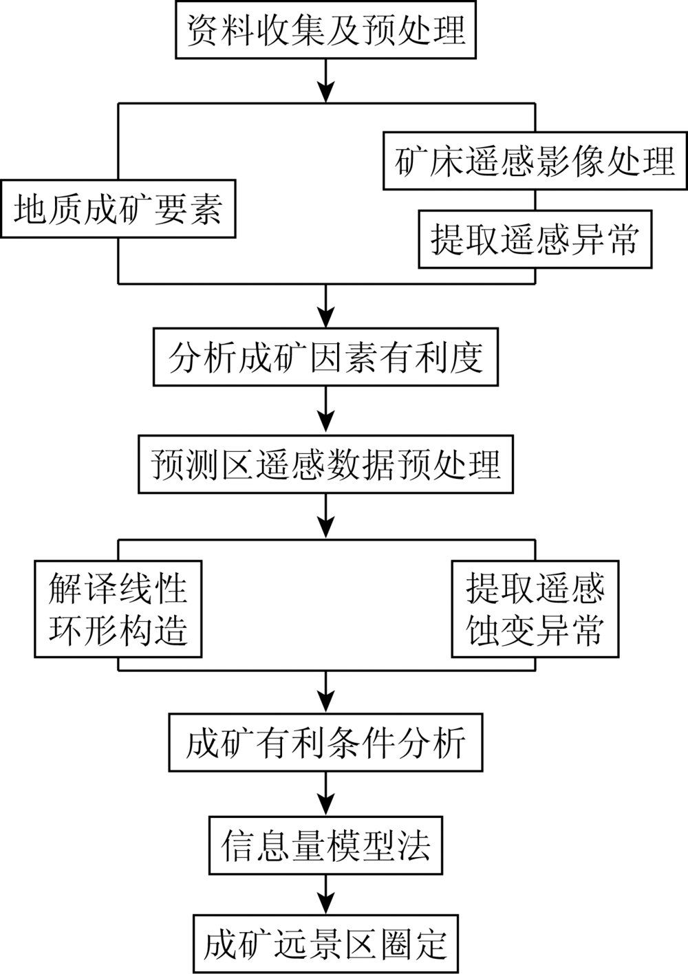
Abstract  

In recent years, China has paid more and more attention to the mineral geology in the northwest frontier area. However, due to natural geography and other reasons, it is difficult to carry out large-scale manual investigation. By collecting and sorting the available data, the authors have found that there are gold, silver, copper, lead and other minerals in the vicinity of Shumu campsite of the northwest frontier area, and hence it is an important metallogenic prospective area of China’s mineral resources. In order to give full play to the advantages and leading role of remote sensing in prospecting in difficult and dangerous areas of Western China, the authors used ASTER remote sensing image data to extract alteration anomalies and controlling factors. On such a basis, various thematic factors which were used to evaluate the metallogenic favorable areas were obtained, and the correlation and usability between thematic factors were investigated. The establishment of remote sensing geological prospecting model and verification through known deposit point information have obtained good evaluation results, which can provide reference for similar study areas in the future.

Keywords ASTER      alteration anomalies      information model      metallogenic prediction     
:  TP79  
Issue Date: 30 August 2019
Service
E-mail this article
E-mail Alert
RSS
Articles by authors
Junbin DUAN
Peng PENG
Zhi YANG
Le LIU
Cite this article:   
Junbin DUAN,Peng PENG,Zhi YANG, et al. Prediction of polymetallic metallogenic favorable area based on ASTER data[J]. Remote Sensing for Land & Resources, 2019, 31(3): 193-200.
URL:  
https://www.gtzyyg.com/EN/10.6046/gtzyyg.2019.03.24     OR     https://www.gtzyyg.com/EN/Y2019/V31/I3/193
Fig.1  Image of study area
Fig.2  Flow chart of information extraction
Fig.3  Spectrum curve of mineral contain aluminum and hydroxyl
特征向量 B1 B3 B4 B6
PC1 0.770 753 0.626 731 0.109 583 0.033 756
PC2 0.632 877 -0.773 870 -0.023 653 -0.005 706
PC3 0.073 474 0.091 289 -0.955 632 -0.270 250
PC4 -0.002 650 -0.000 936 -0.272 396 0.962 181
Tab.1  Eigenvector of PCA of ASTER B1,B3,B4,B6
Fig.4  Alteration anomalies of mineral contain aluminum and hydroxyl
Fig.5  Spectrum curve of mineral contain magnesium and hydroxyl
特征向量 B1 B4 B6 B8
PC1 0.998 683 -0.048 257 -0.014 705 -0.009 387
PC2 0.051 308 0.943 723 0.271 521 0.181 744
PC3 0.000 757 -0.242 232 0.955 284 -0.169 574
PC4 0.000 186 -0.219 958 0.116 157 0.968 569
Tab.2  Eigenvector of PCA of ASTER B1,B4,B6,B8
Fig.6  Alteration anomalies of mineral contain magnesium and hydroxyl
Fig.7  Spectrum curve of mineral contain carbonate
特征向量 B1 B3 B4 B8
PC1 0.770 994 0.626 924 0.109 595 0.022 889
PC2 0.632 640 -0.774 114 -0.022 634 0.001 293
PC3 0.072 924 0.087 735 -0.973 640 -0.197 509
PC4 -0.004 145 -0.004 061 -0.198 750 0.980 033
Tab.3  Eigenvector of PCA of ASTER B1,B3,B4,B8
Fig.8  Alteration anomalies of mineral contain carbonate
Fig.9  Spectrum curve of mineral contain iron
特征向量 B1 B2 B3 B4
PC1 0.604 968 0.621 052 0.490 718 0.086 503
PC2 0.534 382 0.139 250 -0.833 656 -0.007 917
PC3 -0.301 563 0.290 230 -0.153 328 0.895 163
PC4 0.507 432 -0.714 612 0.201 752 0.437 193
Tab.4  Eigenvector of PCA of ASTER B1,B2,B3,B4
Fig.10  Alteration anomalies of iron stain
Fig.11  Linear structure of study area
Fig.12  Circular structure of study area
1 2 3 4 5 6
1 1.000 00 0.095 01 0.172 63 0.188 92 0.208 32 -0.130 34
2 0.095 01 1.000 00 -0.017 95 0.245 76 -0.031 24 -0.124 97
3 0.172 63 -0.017 95 1.000 00 0.211 96 0.957 93 -0.022 92
4 0.188 92 0.245 76 0.211 96 1.000 00 0.231 30 -0.447 48
5 0.208 32 -0.031 24 0.957 93 0.231 30 1.000 00 -0.084 32
6 -0.130 34 -0.124 97 -0.022 92 -0.447 48 -0.084 32 1.000 00
Tab.5  Correlation of factors
因子图层 分类值
铝羟基蚀变 一级异常 二级异常 三级异常 无异常
碳酸盐岩蚀变 一级异常 二级异常 三级异常 无异常
铁染蚀变 一级异常 二级异常 三级异常 无异常
线性构造长度/km ≥3 [2,3) [1,2) <1
环形构造长度/km ≥3 [2,3) [1,2) <1
Tab.6  Classification standard of factors
Fig.13  Mineral foreground area classification of study area
[1] 姚凤良, 孙丰月 . 矿床学教程[M]. 北京: 地质出版社, 2006.
[1] Yao F L, Sun F Y. Course of Mineral Deposit[M]. Beijing: Geologi-cal Publishing House, 2006.
[2] 高景岗 . 新疆北部主要斑岩铜矿带成矿条件及遥感找矿定位研究[D]. 西安:长安大学, 2008.
[2] Gao J G . The Study on the Mineralization Condition of the Major Porphyry Copper Mineral Belt and Remote Sensing Prospecting Localization in Northern Xinjiang,China[D]. Xi’an:Chang’an University, 2008.
[3] 石玉臣 . 山东省焦家成矿带深部金矿预测研究及其应用[D]. 长春:吉林大学, 2005.
[3] Shi Y C . Deeo-Space Metallogenic Predication Study and Its Application in Jiaojia Gold Belt of Shandong[D]. Changchun:Jilin University, 2005.
[4] 范玉海, 王辉, 杨兴科 , 等. 基于高分辨率遥感数据的稀有金属矿化带勘查[J]. 国土资源遥感, 2018,30(1):128-134.doi: 10.6046/gtzyyg.2018.01.18.
[4] Fan Y H, Wang H, Yang X K , et al. Application of high-resolution remote sensing technology to the prospecting for rare metal mineralization belt[J]. Remote Sensing for Land and Resources, 2018,30(1):128-134.doi: 10.6046/gtzyyg.2018.01.18.
[5] 杨金中, 陈薇, 王辉 . 西昆仑成矿带黑恰达坂温泉沟群含铁层位的圈定[J]. 国土资源遥感, 2017,29(3):191-195.doi: 10.6046/gtzyyg.2017.03.28.
[5] Yang J Z, Chen W, Wang H . Delineation of iron formation in Wenquangou Group along Heiqia Pass in West Kunlun metallogenic belt[J]. Remote Sensing for Land and Resources, 2017,29(3):191-195.doi: 10.6046/gtzyyg.2017.03.28.
[6] 范素英 . 层次分析法在冀北地区多金属矿找矿预测中的应用[J]. 国土资源遥感, 2017,29(2):125-131.doi: 10.6046/gtzyyg.2017.02.18.
[6] Fan S Y . Application of analytic hierarchy process method to ore-prospecting prognosis in Northern Hebei[J]. Remote Sensing for Land and Resources, 2017,29(2):125-131.doi: 10.6046/gtzyyg.2017.02.18.
[7] Loughlin W P . Principal component analysis for alteration mapping[J]. Photogrammetric Engineering and Remote Sensing, 1991,57(9):1163-1169.
[8] Rowan L C, Goetz A F H, Ashley R P . Discrimination of hydrothemally altered and unaltered rocks in visible and near infrared multispectral images[J]. Geophysics, 1977(42):522-535.
[9] 高万里, 张绪教, 王志刚 , 等. 基于ASTER遥感图像的东昆仑造山带岩性信息提取研究[J]. 地质力学学报, 2010,16(1):59-67.
[9] Gao W L, Zhang X J, Wang Z G , et al. Extraction of lithologic information form the East Kulun orogenic belt using ASTER remote sensing image[J]. Journal of Geomechanics, 2010,16(1):59-67.
[10] 朱黎江, 秦其明, 陈思锦 . ASTER遥感数据解读与应用[J]. 国土资源遥感, 2003,15(2):59-63.doi: 10.6046/gtzyyg.2003.02.14.
doi: 10.6046/gtzyyg.2003.02.14
[10] Zhu L J, Qin Q M, Chen S J . The reading of ASTER data form file and the application of ASTER data[J]. Remote Sensing for Land and Resources, 2003,15(2):59-63.doi: 10.6046/gtzyyg.2003.02.14.
[11] 张玉君, 杨建民, 姚佛军 . 用ASTER数据进行不同类型矿床蚀变异常提取研究[J]. 矿床地质, 2006,25(s1):507-510.
[11] Zhang Y J, Yang J M, Yao F J . The extraction of OHA form different types of deposits by using ASTER data[J]. Mineral Deposits, 2006,25(s1):507-510.
[12] 安徽地质调查院. 温泉幅、松溪幅区域地质调查报告[R]. 合肥:安徽省地质调查院, 2005.
[12] Geological Survey of Anhui Province. Report of Wenquan and Songxi Regional Geological Survey[R]. Hefei:Geological Survey of Anhui Province, 2005.
[13] 陕西地质调查院. 1:25万康西瓦幅区域地质调查成果报告[R]. 西安:陕西地调院, 2006.
[13] Geological Survey of Shaanxi Province. 1:250 000 Kangxiwa Regional Geological Survey[R]. Xi’an:Geological Survey of Shaanxi Province, 2006.
[14] 张玉君, 曾朝铭, 陈薇 . ETM+(TM)蚀变遥感异常提取方法研究与应用——方法选择和技术流程[J]. 国土资源遥感, 2003,15(2):44-49.doi: 10.6046/gtzyyg.2003.02.11.
doi: 10.6046/gtzyyg.2003.02.11
[14] Zhang Y J, Zeng Z M, Chen W . The methods for extracation of alteration anomalies form the ETM+(TM)data and their application:Method selection and technological flow chart[J]. Remote Sensing for Land and Resources, 2003,15(2):44-49.doi: 10.6046/gtzyyg.2003.02.11.
[15] 曹广真 . 多源数据融合在金矿成矿预测中的应用研究[D]. 青岛:山东科技大学, 2003.
[15] Cao G Z . Application of Multi-Source Data Fusion in Gold Metallogenic Prognosis[D]. Qingdao:Shandong University of Science and Technology, 2003.
[16] 易欢, 李健强, 韩海辉 , 等. 遥感技术在阿尔金贝壳滩地区矿产资源综合调查中的应用[J]. 中国地质调查, 2016,3(4):1-5.
[16] Yi H, Li J Q, Han H H , et al. Application of remote sensing in integrated survey on mineral exploration in Beketan,Altyn[J]. Geologi-cal Survey of China, 2016,3(4):1-5.
[1] LIU Wen, WANG Meng, SONG Ban, YU Tianbin, HUANG Xichao, JIANG Yu, SUN Yujiang. Surveys and chain structure study of potential hazards of ice avalanches based on optical remote sensing technology: A case study of southeast Tibet[J]. Remote Sensing for Natural Resources, 2022, 34(1): 265-276.
[2] FENG Dongdong, ZHANG Zhihua, SHI Haoyue. Fine extraction of urban villages in provincial capitals based on multivariate data[J]. Remote Sensing for Natural Resources, 2021, 33(3): 272-278.
[3] AN Jianjian, MENG Qingyan, HU Die, HU Xinli, YANG Jian, YANG Tianliang. The detection and determination of the working state of cooling tower in the thermal power plant based on Faster R-CNN[J]. Remote Sensing for Land & Resources, 2021, 33(2): 93-99.
[4] DONG Tiancheng, YANG Xiao, LI Hui, ZHANG Zhi, QI Rui. The extraction of plateau lakes from SAR images based on Faster R-CNN and MorphACWE model[J]. Remote Sensing for Land & Resources, 2021, 33(1): 129-137.
[5] Jie CHEN, Zihong GAO, Shanshan WANG, Dingjian JIN. A review on the development of aerial remote sensing geological survey technology in the Three Gorges Reservoir area[J]. Remote Sensing for Land & Resources, 2020, 32(2): 1-10.
[6] Dingjian JIN, Jianchao WANG, Fang WU, Zihong GAO, Yachao HAN, Qi LI. Aerial remote sensing technology and its applications in geological survey[J]. Remote Sensing for Land & Resources, 2019, 31(4): 1-10.
[7] Quan AN, Zhonghua HE, Cuiwei ZHAO, Hong LIANG, Shulin JIAO, Chaohui YANG. GIS-based estimation of fractal dimension and geomorphological development of the water system in the dam construction area[J]. Remote Sensing for Land & Resources, 2019, 31(4): 104-111.
[8] Chenchao XIAO, Xiaojuan WU, Daming WANG, Yongbin CHU. Oil-gas information extraction and prospective area prediction based on hydrocarbon microseepage theory: A case study of Salamat Basin in Central Africa[J]. Remote Sensing for Land & Resources, 2019, 31(4): 120-127.
[9] Honglin MA, Weijie JIA, Changliang FU, Wei LI. Extraction of geological structural and alteration information and the prediction of metallogenic favorable locations in northeastern Jeddah, Saudi Arabia[J]. Remote Sensing for Land & Resources, 2019, 31(3): 174-182.
[10] Qifang XIE, Guoqing YAO, Meng ZHANG. Research on high resolution image object detection technology based on Faster R-CNN[J]. Remote Sensing for Land & Resources, 2019, 31(2): 38-43.
[11] Jianyu LIU, Ling CHEN, Wei LI, Genhou WANG, Bo WANG. An improved method for extracting alteration related to the ductile shear zone type gold deposits using ASTER data[J]. Remote Sensing for Land & Resources, 2019, 31(1): 229-236.
[12] Xiaoping XIE, Maowei BAI, Zhicong CHEN, Weibo LIU, Shuna XI. Remote sensing image interpretation and tectonic activity study of the active faults along the northeastern segment of the Longmenshan fault[J]. Remote Sensing for Land & Resources, 2019, 31(1): 237-246.
[13] Lin WANG, Xun LI, Yunxuan BAO, Yi SHAO. Research progress of remote sensing application on transportation meteorological disasters[J]. Remote Sensing for Land & Resources, 2018, 30(4): 1-7.
[14] Xuecheng WANG, Fei YANG, Xing GAO, Yinghui ZHANG. Assessment of forest damage due to ice-snow disaster based on the method of threshold ratio:A case study of Hunan Province[J]. Remote Sensing for Land & Resources, 2018, 30(3): 196-203.
[15] Kai CHEN, Chengfa FANG, Ru LI. Research on airborne remote sensing emergency flight organization strategy in natural disaster[J]. Remote Sensing for Land & Resources, 2018, 30(3): 55-59.
Viewed
Full text


Abstract

Cited

  Shared   
  Discussed   
京ICP备05055290号-2
Copyright © 2017 Remote Sensing for Natural Resources
Support by Beijing Magtech