|
|
 |
|

|
|
|
A study of metallogenic prognosis of the Dimunalike iron ore belt based on remote sensing and aeromagnetic data |
| Ce ZHANG, Lihong PENG, En ZHANG, Lihua FU, Bing WANG |
| Airborne Survey and Remote Sensing Center of Nuclear Industry, Shijiazhuang 050002, China |
|
|
|
|
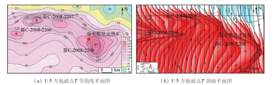
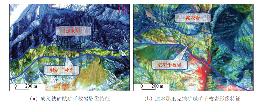
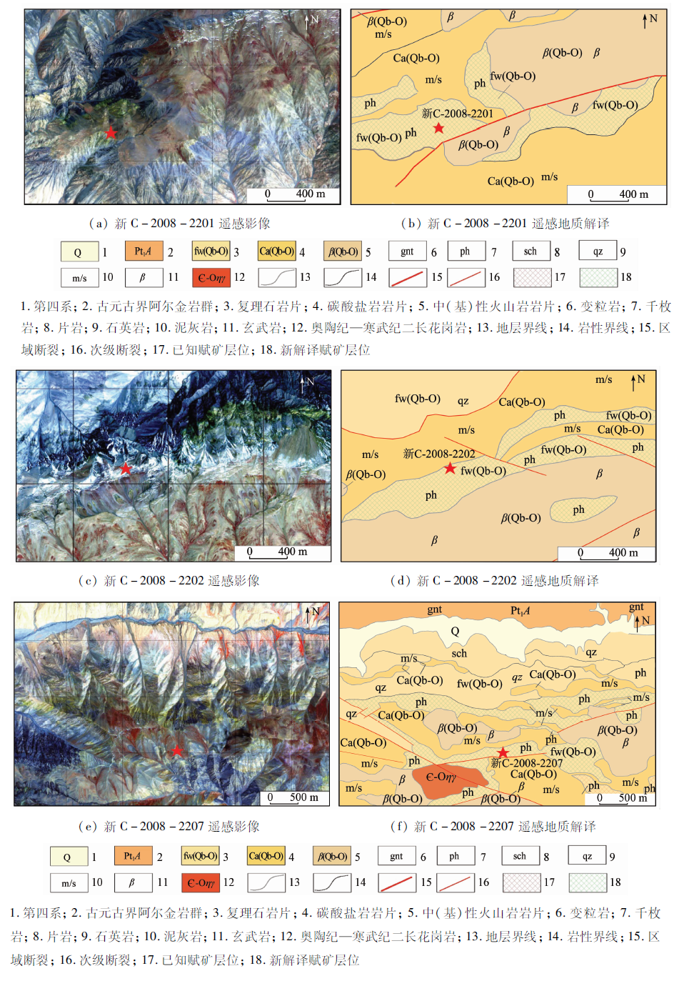
Abstract The Dimunalike iron ore belt is an important iron ore exploration area in western China, where the Dimunalike iron ore deposit, the Yuling iron ore deposit and the Hesu iron ore deposit were discovered. Its geological conditions are superior and the potential for prospecting is huge. Nevertheless, due to its special geological structure and harsh natural geographical conditions, there is a great difficulty in the mineral exploration. In this study, the authors made full use of WorldView-2 high spatial resolution remote sensing data and aeromagnetic data and conducted the decomposition of the Changshagou structure-ophiolite belt to analyze remote sensing and aeromagnetic characteristics of typical deposit of the Dimunalike iron deposit. The authors established a comprehensive prospecting model of sedimentary metamorphic iron ore deposit integrated with geology, aeromagnetic and remote sensing. By using this model, the magnetite ore-bearing target can be located precisely. The results show that the combination of remote sensing and aeromagnetic methods can accurately locate the information such as ore-bearing lithology, ore-controlling structure and mineralized zone. This will improve the accuracy and efficiency of geological exploration.
|
| Keywords
WorldView-2
aeromagnetic data
sedimentary-metamorphic iron ore deposit
prospecting model
Dimunalike iron ore belt
|
|
|
|
Issue Date: 30 August 2019
|
|
|
| [1] |
贾伟洁, 郭华, 李迁 . ASTER遥感影像与航磁梯度数据综合应用[J]. 吉林大学学报(地球科学版), 2015,45(4):1237-1245.
doi: 10.13278/j.cnki.jjuese.201504303
|
| [1] |
Jia W J, Guo H, Li Q . Integrated application of ASTER remote sensing image and aeromagnetic gradient data[J]. Journal of Jilin University(Earth Science Edition), 2015,45(4):1237-1245.
|
| [2] |
毛德宝, 钟长汀, 牛广华 , 等. 阿尔金成矿带成矿规律与找矿预测[J]. 西北地质, 2006,39(2):114-127.
|
| [2] |
Mao D B, Zhong C T, Niu G H , et al. Study on metallogenic characteristics and target areas in the Altyn Tagh metallogenic zone[J]. Northwestern Geology, 2006,39(2):114-127.
|
| [3] |
伍跃中, 庄道泽, 李洪茂 , 等. 新疆祁漫塔格找矿远景区重要矿产整装勘查[J]. 西北地质, 2010,43(4):25-34.
|
| [3] |
Wu Y Z, Zhuang D Z, Li H M , et al. The important mineral integrated exploration of Qimantage potential prospecting area in Xinjiang region[J]. Northwestern Geology, 2010,43(4):25-34.
|
| [4] |
李文渊 . 祁漫塔格找矿远景区地质组成及勘查潜力[J]. 西北地质, 2010,43(4):1-9.
|
| [4] |
Li W Y . The geological composition and metallogenetic prospect in the Qimantage prospective region,East Kunlun[J]. Northwestern Geology, 2010,43(4):1-9.
|
| [5] |
刘艳宾, 弓小平, 陈斌 , 等. 东昆仑山西段铁矿成矿机制和找矿模型[J]. 地质通报, 2011,30(12):1950-1961.
|
| [5] |
Liu Y B, Gong X P, Chen B , et al. Metallogenic mechanism and prospecting model of iron deposits in the western segment of East Kunlun Mountain[J]. Geological Bulletin of China, 2011,30(12):1950-1961.
|
| [6] |
杨文强, 丁海波, 刘良 , 等. 新疆阿尔金南部迪木那里克铁矿赋矿地层的形成时代及其地质意义[J]. 地质通报, 2012,31(12):2090-2101.
|
| [6] |
Yang W Q, Ding H B, Liu L , et al. Formation age of ore-bearing strata of the Dimunalike iron deposit in South Altun Mountains and its geological significance[J]. Geological Bulletin of China, 2012,31(12):2090-2101.
|
| [7] |
丁海波, 杨晓飞, 张朋 , 等. 新疆东昆仑迪木那里克铁矿床地质特征及找矿方向[J]. 矿床地质, 2013,32(1):195-206.
|
| [7] |
Ding H B, Yang X F, Zhang P , et al. Geological characteristics and prospecting direction of Dimunalike iron deposit in East Kunlun,Xinjiang[J]. Mineral Deposits, 2013,32(1):195-206.
|
| [8] |
丁海波, 张朋, 杨晓飞 , 等. 新疆东昆仑迪木那里克铁矿床及其外围找矿新发现[J]. 矿床地质, 2013,32(1):122-132.
|
| [8] |
Ding H B, Zhang P, Yang X F , et al. New prospecting discoveries in Dimunalike iron deposit and its peripheralareas in East Kunlun Mountains,Xinjiang[J]. Mineral Deposits, 2013,32(1):122-132.
|
| [9] |
杨金中, 陈薇, 王辉 . 西昆仑成矿带黑恰达坂温泉沟群含铁层位的圈定[J]. 国土资源遥感, 2017,29(3):191-195.doi: 10.6046/gtzyyg.2017.03.28.
|
| [9] |
Yang J Z, Chen W, Wang H . Delineation of iron formation in Wenquangou Group along Heiqia Pass in West Kunlun metallogenic belt[J]. Remote Sensing for Land and Resources, 2017,29(3):191-195.doi: 10.6046/gtzyyg.2017.03.28.
|
| [10] |
张微, 金谋顺, 张少鹏 , 等. 高分遥感卫星数据在东昆仑成矿带找矿预测中的应用[J]. 国土资源遥感, 2016,28(2):112-119.doi: 10.6046/gtzyyg.2016.02.18.
doi: 10.6046/gtzyyg.2016.02.18
|
| [10] |
Zhang W, Jin M S, Zhang S P , et al. Application of high resolution remote sensing data to ore-prospecting prediction in East Kunlun metallogenic belt[J]. Remote Sensing for Land and Resources, 2016,28(2):112-119.doi: 10.6046/gtzyyg.2016.02.18.
|
| [11] |
张策, 彭莉红, 汪冰 , 等. WorldView2影像在新疆迪木那里克地区火山沉积变质型铁矿勘查中的应用[J]. 矿产勘查, 2015,6(5):523-528.
|
| [11] |
Zhang C, Peng L H, Wang B , et al. Application of WorldView2 remote sensing image in the exploration of the volcano-sedimentary metamorphic type iron deposits in the Dimunalike area,Xinjiang[J]. Mineral Exploration, 2015,6(5):523-528.
|
| [12] |
范玉海, 王辉, 杨兴科 , 等. 基于高分辨率遥感数据的稀有金属矿化带勘查[J]. 国土资源遥感, 2018,30(1):128-134.doi: 10.6046/gtzyyg.2018.01.18.
|
| [12] |
Fan Y H, Wang H, Yang X K , et al. Application of high-resolution remote sensing technology to the prospecting for rare metal mineralization belt[J]. Remote Sensing for Land and Resources, 2018,30(1):128-134.doi: 10.6046/gtzyyg.2018.01.18.
|
| [13] |
陈玲, 张微, 周艳 , 等. 高分辨率遥感影像在新疆塔什库尔干地区沉积变质型铁矿勘查中的应用[J]. 地质与勘探, 2012,48(5):1039-1048.
|
| [13] |
Chen L, Zhang W, Zhou Y , et al. Application of high-resolution remote sensing images to searching for sedimentary-metamorphic type iron deposits in the Taxkorgan area,Xinjiang[J]. Geology and Exploration, 2012,48(5):1039-1048.
|
| [14] |
杨金中, 孙延贵, 秦绪文 , 等. 高分辨率遥感地质调查[M]. 北京: 测绘出版社, 2013.
|
| [14] |
Yang J Z, Shun Y G, Qin X W , et al. High Resolution Remote Sensing Technology on Geological Survey[M]. Beijing: Surveying and Mapping Press, 2013.
|
| [15] |
金剑, 田淑芳, 焦润成 , 等. 基于地物光谱分析的WorldView-2数据岩性识别:以新疆乌鲁克萨依地区为例[J]. 现代地质, 2013,27(2):489-496.
|
| [15] |
Jin J, Tian S F, Jiao R C , et al. Lithology identification with WorldView-2 data based on spectral analysis of surface features:A case study of Wulukesayi District in Xinjiang[J]. Geoscience, 2013,27(2):489-496.
|
| [16] |
伍跃中, 赵晓健, 乔耿彪 , 等. 阿尔金成矿带的归属及成矿特征[J]. 大地构造与成矿学, 2017,41(4):689-697.
|
| [16] |
Wu Y Z, Zhao X J, Qiao G B , et al. Ascription and metallogenic characteristics of Altyn orogenic belt[J]. Geotectonica et Metallogenia, 2017,41(4):689-697.
|
| [17] |
石福品, 陈登辉, 张海军 . 新疆且末县迪木那里克铁矿床地质特征与找矿潜力分析[J]. 西北地质, 2010,43(4):203-208.
|
| [17] |
Shi F P, Chen D H, Zhang H J . Exploration progress around Dimnalic iron deposit in Qiemo County,Xinjiang[J]. Northwestern Geo-logy, 2010,43(4):203-208.
|
| [18] |
谭文娟, 姜寒冰, 杨合群 , 等. 祁漫塔格地区铁多金属矿床成矿特征及成因探讨[J]. 地质与勘探, 2011,47(2):244-250.
|
| [18] |
Tan W J, Jiang H B, Yang H Q , et al. Metallogenic features and genesis of Fe polymetallic deposits in the Qimantage region[J]. Geology and Exploration, 2011,47(2):244-250.
|
|
Viewed |
|
|
|
Full text
|
|
|
|
|
Abstract
|
|
|
|
|
Cited |
|
|
|
|
| |
Shared |
|
|
|
|
| |
Discussed |
|
|
|
|
 2019,
Vol. 31
2019,
Vol. 31