|
|
 |
|

|
|
|
Potential evaluation of China’s coastal airborne LiDAR bathymetry based on CZMIL Nova |
| Qi LI1,2, Jianchao WANG1, Yachao HAN1, Zihong GAO1, Yongjun ZHANG1, Dingjian JIN1 |
1. China Aero Geophysical Survey and Remote Sensing Center for Natural Resources, Beijing 100083, China
2. Key Laboratory of Airborne Geophysics and Remote Sensing Geology, Ministry of Natural Resources, Beijing 100083, China |
|
|
|
|
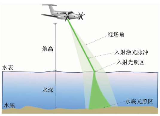
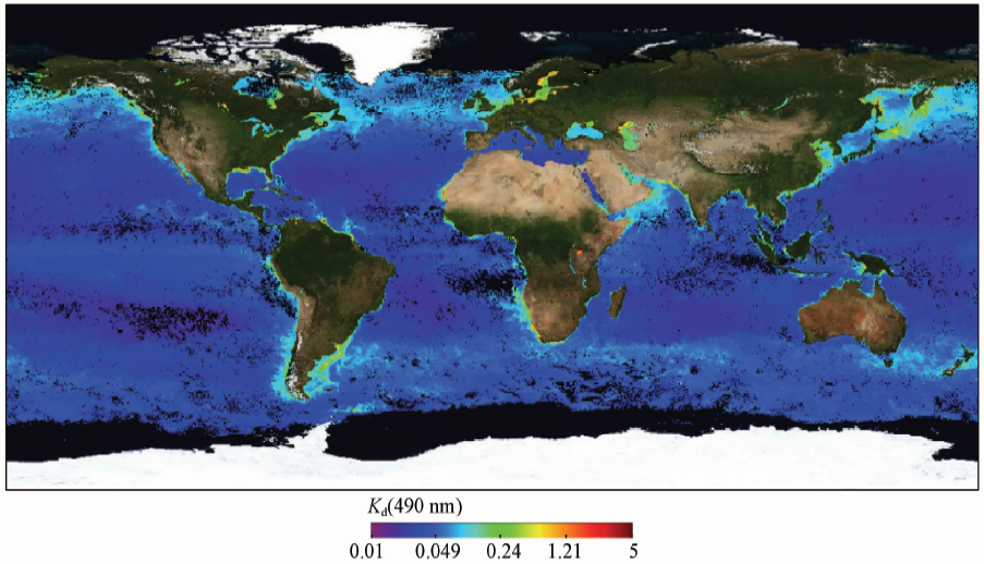
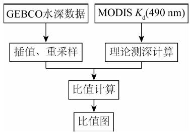
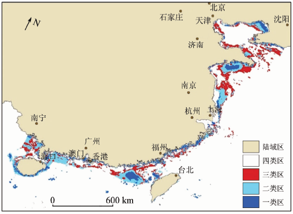
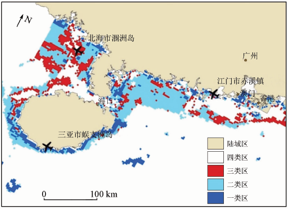
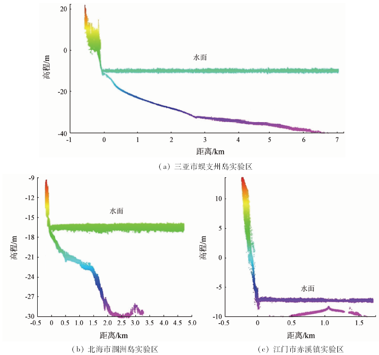
Abstract Water transparency is the key factor of airborne LiDAR bathymetry. Turbid waters produce noise in LiDAR echo signal and weaken the laser pulse or cause a gap. Therefore, it is necessary to study water optical properties. Using MODIS Kd (490 nm) and general bathymetric chart of the oceans (GEBCO) bathymetric data, the authors calculated the maximum detectable depth in China’s coastal area based on CZMIL Nova, and classified the result into 3 types. CZMIL test data from different areas were used to verify the accuracy of the classification. The results show that a total of 211,900 km 2 sea area is suitable for the performance of bathymetric survey with airborne LiDAR. The coastal area of Wenchang to Dongfang of Hainan, Beihai and the east and west of Leizhou peninsula, Rizhao to Qindao of Shangdong and Yinzhou to Suizhong of Liaodong Bay are suitable for the performance of land and sea integrating topographic survey, with the maximum measurable depths estimated by Kd being 20~40 m, 10~20 m, 20~25 m, 10~15 m, respectively.
|
| Keywords
airborne LiDAR
Kd
CZMIL Nova
potential area
|
|
|
|
Issue Date: 14 March 2020
|
|
|
| [1] |
杨静, 张仁铎, 翁士创 , 等. 海岸带环境承载力评价方法研究[J]. 中国环境科学, 2013,33(s1):178-185.
|
| [1] |
Yang J, Zhang R D, Weng S C , et al. The assessment method of coastal environmental carrying capacity[J]. China Environmental Science, 2013,33(s1):178-185.
|
| [2] |
温文 . 基于相关特性的水下连续激光后向散射测量方法研究[D]. 哈尔滨:哈尔滨工程大学, 2007.
|
| [2] |
Wen W . Research on Underwater Continuous Laser Backscattering Measurement Method Based on Correlation Characteristics[D]. Harbin:Harbin Engineering University, 2007
|
| [3] |
Feygels V, Ramnath V, Smith B , et al. Meeting the international hydrographic organization requirements for bottom feature detection using the coastal zone mapping and imaging LiDAR (CZMIL)[C]// Oceans.IEEE, 2016.
|
| [4] |
李志忠 . 机载激光雷达系统及其在海洋调查中的应用前景[J]. 地学前缘, 1998,5(2):246.
|
| [4] |
Li Z Z . Airborne LiDAR and its application prospects in marine surveys[J]. Earth Science Frontiers, 1998,5(2):246.
|
| [5] |
付成群, 律秀原, 王勇 , 等. 机载激光雷达海洋探测的模拟研究[J]. 系统仿真学报, 2015,27(5):1038-1043.
|
| [5] |
Fu C Q, Lyu X Y, Wang Y , et al. Simulation research on airborne LiDAR bathymetry system[J]. Journal of System Simulation, 2015,27(5):1038-1043.
|
| [6] |
丁凯, 李清泉, 朱家松 , 等. 运用MODIS遥感数据评测南海北部区域机载激光雷达测深系统参数[J]. 测绘学报, 2018,47(2):180-187.
|
| [6] |
Ding K, Li Q Q, Zhu J S , et al. Evaluation of airborne LiDAR bathymetric parameters on the northern South China Sea based on MODIS data[J]. Acta Geodaetica et Cartographica Sinica, 2018,47(2):180-187.
|
| [7] |
李凯, 童晓冲, 张永生 , 等. 黄海、东海区域漫衰减系数光谱遥感反演及激光测深性能评估[J]. 遥感学报, 2015,19(5):761-769.
|
| [7] |
Li K, Tong X C, Zhang Y S , et al. Inversion of diffuse attenuation coefficient spectral in the Yellow Sea/East China Sea and evaluation of laser bathymetric performance[J]. Journal of Remote Sensing, 2015,19(5):761-769.
|
| [8] |
丁凯, 李清泉, 朱家松 , 等. 海南岛沿岸海域水体漫衰减系数光谱分析及LiDAR测深能力估算[J]. 光谱学与光谱分析, 2018,38(5):1582-1587.
|
| [8] |
Ding K, Li Q Q, Zhu J S , et al. Analysis of diffuse attenuation coefficient spectra of coastal waters of Hainan Island and performance estimation of airborne LiDAR bathymetry[J]. Spectroscopy and Spectral Analysis, 2018,38(5):1582-1587.
|
| [9] |
Muirhead K, Cracknell A P . Airborne LiDAR bathymetry[J]. International Journal of Remote Sensing, 1986,7(5):597-614.
|
| [10] |
Sizgoric S, Banic J, LaRocque P . The history of laser bathymetry[M]// Lampropoulos G A,Chrostowski J,Measures R M.Applications of Photonic Technology.Boston:Springer, 1995: 207-217.
|
| [11] |
Fernandez-Diaz J C, Glennie C L, Carter W E , et al. Early results of simultaneous terrain and shallow water bathymetry mapping using a single-wavelength airborne LiDAR sensor[J]. IEEE Journal of Selected Topics in Applied Earth Observations and Remote Sensing, 2014,7(2):623-635.
|
| [12] |
秦海明, 王成, 习晓环 , 等. 机载激光雷达测深技术与应用研究进展[J]. 遥感技术与应用, 2016,31(4):617-624.
|
| [12] |
Qing H M, Wang C, Xi X H , et al. Development of airborne laser bathymetric technology and applications[J]. Remote Sensing Technology and Application, 2016,31(4):617-624.
|
| [13] |
Feygels V I, Park J Y, Wozencraft J , et al. CZMIL(coastal zone mapping and imaging LiDAR):From first flights to first mission through system validation[C]// Ocean Sensing and Monitoring V, 2013.
|
| [14] |
Aitken J, Ramnath V, Feygels V , et al. Prelude to CZMIL:Seafloor imaging and classification results achieved with CHARTS and the rapid environmental assessment (REA) processor[J]. Proceedings of SPIE-the International Society for Optical Engineering, 2010.
|
| [15] |
Feygels V, Ramnath V, Marthouse R , et al. CZMIL as a rapid environmental disaster response tool[C]// Oceans.Aberdeen:IEEE, 2017.
|
| [16] |
Gordon H R, Smith R C, Zaneveld J R V . Introduction to ocean optics[C]// Ocean Optics VII, 1980,208:14-55.
|
| [17] |
Austin R W, Petzold T J . Spectral dependence of the diffuse attenuation coefficient of light in ocean waters[C]// Ocean Optics VII, 1984,489:168.
|
| [18] |
赵文静, 曹文熙, 胡水波 , 等. MODIS-Aqua漫射衰减产品Kd(490)在南海海域的精度对比[J]. 光学精密工程, 2018,26(1):14-24.
|
| [18] |
Zhao W J, Chao W X, Hu S B , et al. Comparison of diffuse attenuation coefficient of downwelling irradiance products derived from MODIS-Aqua in the South China Sea[J]. Optics and Precision Engineering, 2018,26(1):14-24.
|
| [19] |
Werdell P J, Bailey S W . An improved in-situ bio-optical data set for ocean color algorithm development and satellite data product validation[J]. Remote Sensing of Environment, 2005,98(1):122-140.
|
|
Viewed |
|
|
|
Full text
|
|
|
|
|
Abstract
|
|
|
|
|
Cited |
|
|
|
|
| |
Shared |
|
|
|
|
| |
Discussed |
|
|
|
|
 2020,
Vol. 32
2020,
Vol. 32