Please wait a minute...
 
Remote Sensing for Natural Resources    2022, Vol. 34 Issue (1) : 286-292     DOI: 10.6046/zrzyyg.2021098
|
Application of 3D information extraction technology of ground obstacles in the flight trajectory planning of UAV airborne geophysical exploration
WU Fang(), LI Yu(), JIN Dingjian, LI Tianqi, GUO Hua, ZHANG Qijie
China Aero Geophysical Survey and Remote Sensing Center for Natural Resources, Beijing 100083, China
Download: PDF(3395 KB)   HTML
Export: BibTeX | EndNote | Reference Manager | ProCite | RefWorks    
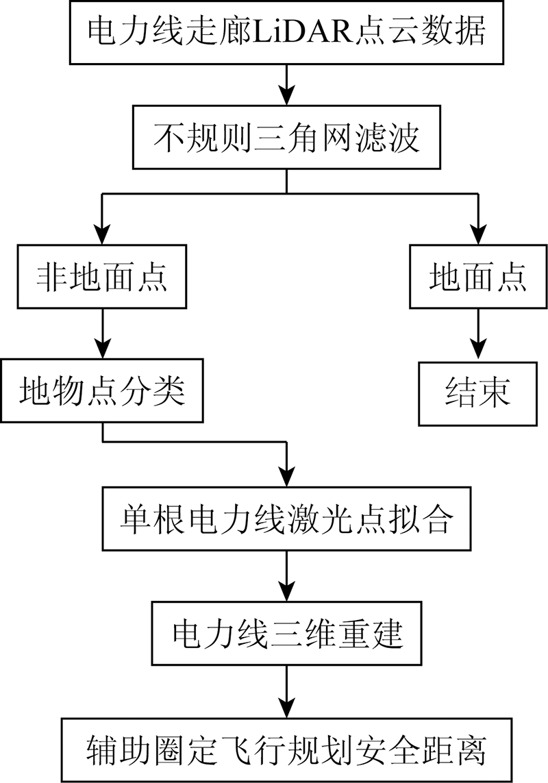
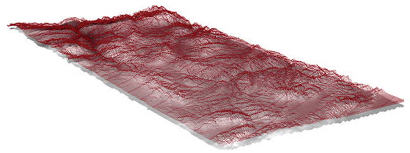
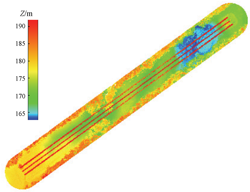
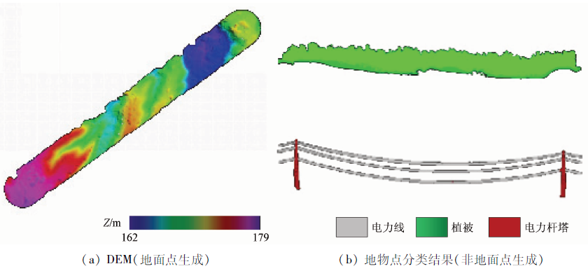
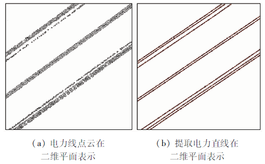
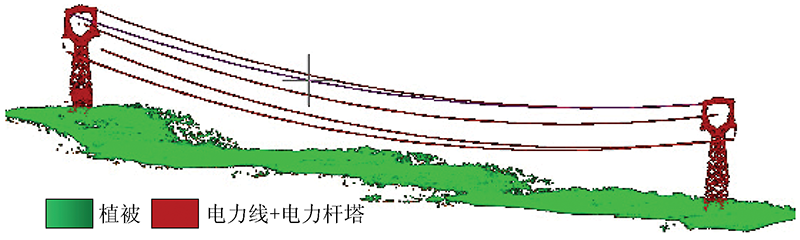
Abstract  

UAV airborne geophysical exploration has become an emerging branch of airborne geophysical exploration technology. To obtain high-quality measured data in UAV airborne geophysical exploration, it is necessary to plan UAV flight trajectory according to the application characteristics of airborne geophysical exploration. Focusing on the demand for 3D planning of UAV flight trajectory and autonomous obstacle avoidance, this paper studied the 3D information extraction technology of ground obstacles based on point cloud data of UAV LiDAR and extracted ground points and non-ground points (e.g., transmission towers, power line points, and vegetation points). The construction of terrain information and the 3D reconstruction of transmission towers and power lines will provide important primary data for UAV 3D flight trajectory planning software.

Keywords airborne lidar      UAV      power line extraction      filtering     
ZTFLH:  TP79  
Corresponding Authors: LI Yu     E-mail: 4402744@qq.com;gtzyygliyu@163.com
Issue Date: 14 March 2022
Service
E-mail this article
E-mail Alert
RSS
Articles by authors
Fang WU
Yu LI
Dingjian JIN
Tianqi LI
Hua GUO
Qijie ZHANG
Cite this article:   
Fang WU,Yu LI,Dingjian JIN, et al. Application of 3D information extraction technology of ground obstacles in the flight trajectory planning of UAV airborne geophysical exploration[J]. Remote Sensing for Natural Resources, 2022, 34(1): 286-292.
URL:  
https://www.gtzyyg.com/EN/10.6046/zrzyyg.2021098     OR     https://www.gtzyyg.com/EN/Y2022/V34/I1/286
Fig.1  Barrier information extraction flow chart
Fig.2  Schematic diagram of the filtering parameters
Fig.3  Power line space characteristics
特征 符号 特征描述 可区分类别
高程 H 基于电力线点云间高程变化小,以中心线为基准设定搜索范围格网,格网高程差在一定阈值范围内 电力线、植被
角度 J 基于电力线水平方向投影呈平行线特性,设定点云间最小角度阈值 电力线、植被
距离 D 基于电力线线性延伸特征,判断2个点之间距离不超过阈值 电力线、电力杆塔
Tab.1  Description of the power line point cloud characteristics
Fig.4  Manual editing of non-ground miserror results
Fig.5  Create a 3D survey network using the point cloud terrain information
Fig.6  Schematic diagram of the point cloud data
Fig.7  Point cloud classification results
Fig.8  Power line extraction
Fig.9  Modeling of the 3D corridor of the power line
位置点 1 2 3 4 5 6 7 8 9 10 平均值
水平距离 0.09 0.06 0.12 0.02 0.05 0.09 0.06 0.07 0.02 0.03 0.06
垂直距离 0.23 -0.22 -0.26 -0.23 -0.2 0.24 0.22 -0.11 -0.29 -0.25 0.09
Tab.2  Power line fitting precision(m)
Fig.10  Example of flight planning 3D measuring network output
距第一点距离 地形高程 飞行高程 离地高度
0 177.0 318.6 141.6
0.5 177.0 318.6 141.6
1.0 177.0 318.7 141.7
1.5 177.8 318.8 141.0
2.0 178.0 318.8 140.8
2.5 178.0 318.9 140.9
3.0 178.0 318.9 140.9
3.5 178.0 319.0 141.0
4.0 178.0 319.1 141.1
4.5 178.8 319.1 140.3
5.0 179.0 319.2 140.2
5.5 179.0 319.2 140.2
6.0 179.0 319.3 140.3
6.5 179.0 319.4 140.4
7.0 179.0 319.4 140.4
7.5 179.0 319.5 140.5
8.0 179.0 319.5 140.5
8.5 179.0 319.6 140.6
9.0 179.0 319.7 140.7
9.5 179.0 319.7 140.7
10.0 179.0 319.8 140.8
10.5 179.0 319.8 140.8
11.0 179.0 319.9 140.9
11.5 179.0 320.0 141.0
12.0 179.0 320.0 141.0
12.5 179.0 320.1 141.1
13.0 179.0 320.1 141.1
13.5 179.0 320.2 141.2
14.0 179.0 320.3 141.3
14.5 179.0 320.3 141.3
15.0 179.5 320.4 140.9
Tab.3  Air route flight height-topographical statistics(m)
Fig.11  Flight height and topographical profile of the test area
[1] 李军峰, 李文杰, 秦绪文, 等. 新型无人机航磁系统在多宝山矿区的应用试验[J]. 物探与化探, 2014, 38(4):846-850.
[1] Li J F, Li W J, Qin X W, et al. Trial survey of a novel UAV-borne magnetic system in the Duobaoshan ore district[J]. Geophysical and Geochemical Exploration, 2014, 38(4):846-850.
[2] 李文杰, 李军峰, 刘世凯, 等. 自主技术无人机航空物探(磁/放)综合站研发进展[J]. 地球学报, 2014, 35(4):399-403.
[2] Li W J, Li J F, Liu S K, et al. The progress in the development of the integrated UAV magnetic and radiation survey system[J]. Acta Geoscientica Sinica, 2014, 35(4):399-403.
[3] 余洁, 穆超, 冯延明, 等. 机载LiDAR点云数据中电力线的提取方法研究[J]. 武汉大学学报(信息科学版), 2011, 36(11):1275-1279.
[3] Yu J, Mu C, Feng Y M, et al. Powerlines extraction techniques from airborne LiDAR data[J]. Geomatics and Information Science of Wuhan University, 2011, 36(11):1275-1279.
[4] 阮峻, 陶雄俊, 韦新科, 等. 基于固定翼无人机激光雷达点云数据的输电线路三维建模与树障分析[J]. 南方能源建设, 2019, 6(1):114-118.
[4] Ruan J, Tao X J, Wei X K, et al. 3D modeling and tree barrier analysis of transmission lines based on LiDAR point cloud data of fixed wing UAV[J]. Southern Energy Construction, 2019, 6(1):114-118.
[5] Sohn H B K A. Point-based classification of power line corridor scene using random forests[J]. American Society for Photogrammetry and Remote Sensing, 2013, 13:821-833.
[6] 徐博, 刘正军, 王坚. 基于激光点云数据电力线的提取及安全检测[J]. 激光杂志, 2017, 38(7):48-51.
[6] Xu B, Liu Z J, Wang J. Extraction and security detection of power line based on Laser point cloud data[J]. Laser Journal, 2017, 38(7):48-51.
[7] 王和平, 夏少波, 谭弘武, 等. 电力巡线中机载激光点云数据处理的关键技术[J]. 地理空间信息, 2015, 13(5):59-62.
[7] Wang H P, Xia S B, Tan H W, et al. Key technologies of airborne Laser point cloud process in power line patrol[J]. Geospatial Information, 2015, 13(5):59-62.
[8] 叶清泉, 吴德智, 李卫红. 利用无人机LiDAR点云数据进行电力线危险点检测[J]. 测绘通报, 2015(11):57-59.
[8] Ye Q Q, Wu D Z, Li W H. Powerline danger point detection using UAV LiDAR point cloud[J]. Bulletin of Surveying and Mapping, 2015(11):57-59.
[9] Axelsson P. DEM generation from Laser scanner data using adaptive TIN models[J]. International Archives of Photogrammetry and Remote Sensing, 2000(b4):110-117.
[10] 苏伟, 赵晓凤, 张明政, 等. 基于机载激光雷达点云的飞行障碍物提取方法研究[J]. 农业机械学报, 2017, 12(48):79-85.
[10] Su W, Zhao X F, Zhang M Z, et al. Extracting flying obstacles using airborne LiDAR point cloud data[J]. Transactions of the Chinese Society for Agricultural Machinery, 2017, 12(48):79-85.
[11] 吴芳, 张宗贵, 郭兆成, 等. 基于机载LiDAR点云滤波的矿区DEM构建方法[J]. 自然资源遥感, 2015, 27(1):62-67.doi: 10.6046/gtzyyg.2015.01.10.
doi: 10.6046/gtzyyg.2015.01.10
[11] Wu F, Zhang Z G, Guo Z C, et al. Method of deriving DEM in the mining area based on filtering of airborne LiDAR data[J]. Remote Sensing for Land and Resources, 2015, 27(1):62-67.doi: 10.6046/gtzyyg.2015.01.10.
doi: 10.6046/gtzyyg.2015.01.10
[12] 隋立春, 张熠斌, 张硕, 等. 基于渐进三角网的机载LiDAR点云数据滤波[J]. 武汉大学学报(信息科学版), 2011, 36(10):1159-1163.
[12] Sui L C, Zhang Y B, Zhang S, et al. Filtering of airborne LiDAR point cloud data based on progressive TIN[J]. Geomatics and Information Science of Wuhan University, 2011, 36(10):1159-1163.
[13] 麻卫峰, 王金亮, 王成, 等. 一种基于机载LiDAR点云电力线自动提取方法[J]. 测绘科学技术学报, 2019, 36(1):39-44.
[13] Ma W F, Wang J L, Wang C, et al. An extraction algorithm of power lines from airborne LiDAR point clouds[J]. Journal of Geomatics Science and Technology, 2019, 36(1):39-44.
[14] 赵浩杰, 谭骏详, 雷杰, 等. 基于几何特征的无人机激光雷达电力线提取[J]. 测绘通报, 2020(s1):145-150.
[14] Zhao H J, Tan J X, Lei J, et al. Transmission line extraction from UAV-LiDAR based on geometric features[J]. Bulletin of Surveying and Mapping, 2020(s1):145-150.
[15] 袁晨鑫, 官云兰, 张晶晶, 等. 基于改进Hough变换的电力线提取[J]. 北京测绘, 2018, 32(6):730-733.
[15] Yuan C X, Guan Y L, Zhang J J, et al. Power line extraction based on improved hough transform[J]. Beijing Surveying and Mapping, 2018, 32(6):730-733.
[16] 游安清, 潘旭东, 赵平, 等. 激光雷达电力巡线点云自动分类方法研究[J]. 应用光学, 2019, 40(6):1077-1083.
[16] You A Q, Pan X D, Zhao P, et al. Research on automatic classification of point cloud scanned by LiDAR during power-line patrol[J]. Journal of Applied Optics, 2019, 40(6):1077-1083.
doi: 10.5768/JAO201940.0602005 url: http://www.yygx.net/cn/article/doi/10.5768/JAO201940.0602005
[1] WANG Zhenhua, TAN Zhilian, LI Jing, CHANG Yingli. Re-YOLOX: A YOLOX model for identifying nearshore monitoring targets improved based on the Resizer model[J]. Remote Sensing for Natural Resources, 2023, 35(3): 10-16.
[2] CHEN Kai, WANG Chun, DAI Wen, SHENG Yehua, LIU Aili, TANG Guoan. Factors influencing the terrain modeling accuracy of UAV photogrammetry based on Monte Carlo tests of control points[J]. Remote Sensing for Natural Resources, 2023, 35(3): 107-115.
[3] MENG Congtang, ZHAO Yindi, HAN Wenquan, HE Chenyang, CHEN Xiqiu. RandLA-Net-based detection of urban building change using airborne LiDAR point clouds[J]. Remote Sensing for Natural Resources, 2022, 34(4): 113-121.
[4] HE Peng, YAN Yuyan, WEN Yan, MA Zhigang, JIAO Qisong, GUO Zhaocheng, MO You. Application of the airborne LiDAR technology in the identification of flat landslides and their crack grooves[J]. Remote Sensing for Natural Resources, 2022, 34(4): 307-316.
[5] DONG Shuangfa, FAN Xiao, SHI Haigang, XU Liping, ZHANG Xinyi. Study on distribution of thermal discharge in Fuqing nuclear power plant based on Landsat8 and UAV[J]. Remote Sensing for Natural Resources, 2022, 34(3): 112-120.
[6] ZHANG Shu, ZHOU Zhongfa, WANG Lingyu, CHEN Quan, LUO Jiancheng, ZHAO Xin. Inversion of moisture in surface soil of farmland in karst mountainous areas using multi-temporal SAR images[J]. Remote Sensing for Natural Resources, 2022, 34(3): 154-163.
[7] ZHAO Xiaowei, HUANG Yang, WANG Yongqiang, CHU Ding. Estimation of maize seedling number based on UAV multispectral data[J]. Remote Sensing for Natural Resources, 2022, 34(1): 106-114.
[8] REN Chaofeng, PU Yuchi, ZHANG Fuqiang. A method for extracting match pairs of UAV images considering geospatial information[J]. Remote Sensing for Natural Resources, 2022, 34(1): 85-92.
[9] ZANG Chuankai, SHEN Fang, YANG Zhengdong. Aquatic environmental monitoring of inland waters based on UAV hyperspectral remote sensing[J]. Remote Sensing for Natural Resources, 2021, 33(3): 45-53.
[10] LI Yang, YUAN Lin, ZHAO Zhiyuan, ZHANG Jinlei, WANG Xianye, ZHANG Liquan. Inversion of tidal flat topography based on unmanned aerial vehicle low-altitude remote sensing and field surveys[J]. Remote Sensing for Natural Resources, 2021, 33(3): 80-88.
[11] LIU Yongmei, FAN Hongjian, GE Xinghua, LIU Jianhong, WANG Lei. Estimation accuracy of fractional vegetation cover based on normalized difference vegetation index and UAV hyperspectral images[J]. Remote Sensing for Natural Resources, 2021, 33(3): 11-17.
[12] BAI Junlong, WANG Zhangqiong, YAN Haitao. A K-means clustering-guided threshold-based approach to classifying UAV remote sensed images[J]. Remote Sensing for Natural Resources, 2021, 33(3): 114-120.
[13] WU Yu, ZHANG Jun, LI Yixu, HUANG Kangyu. Research on building cluster identification based on improved U-Net[J]. Remote Sensing for Land & Resources, 2021, 33(2): 48-54.
[14] XIA Yan, HUANG Liang, CHEN Pengdi. Tobacco fine extraction from UAV image based on fuzzy-superpixel segmentation algorithm[J]. Remote Sensing for Land & Resources, 2021, 33(1): 115-122.
[15] XIONG Yujiu, ZHAO Shaohua, YAN Chunhua, QIU Gouyu, SUN Hua, WANG Yanlin, QIN Longjun. A comparative study of methods for monitoring and assessing urban green space resources at multiple scales[J]. Remote Sensing for Land & Resources, 2021, 33(1): 54-62.
Viewed
Full text


Abstract

Cited

  Shared   
  Discussed   
京ICP备05055290号-2
Copyright © 2017 Remote Sensing for Natural Resources
Support by Beijing Magtech