|
|
 |
|

|
|
|
Extraction of early paddy rice area in Lingao County based on Sentinel-1A data |
Jingjian LIU1,2, Hongzhong LI1( ), Cui HUA3, Yuman SUN4, Jinsong CHEN1, Yu HAN1 ), Cui HUA3, Yuman SUN4, Jinsong CHEN1, Yu HAN1 |
1. Shenzhen Institute of Advanced Technology, Chinese Academy of Sciences, Shenzhen 518055, China
2. Land Resources Surveying and Mapping Institute of Guangxi Zhuang Autonomous Region, Nanning 530023, China
3. School of Natural Resources and Surveying, Nanning Normal University, Nanning 530001, China
4. College of Land and Resources Engineering, Kunming University of Science and Technology, Kunming 650500, China |
|
|
|
|
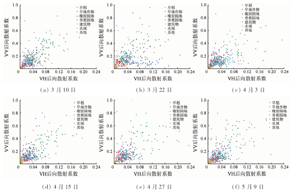
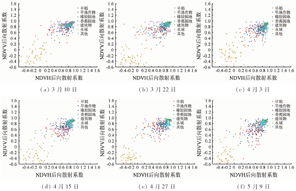
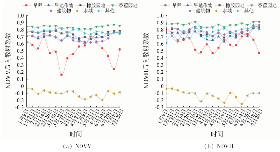
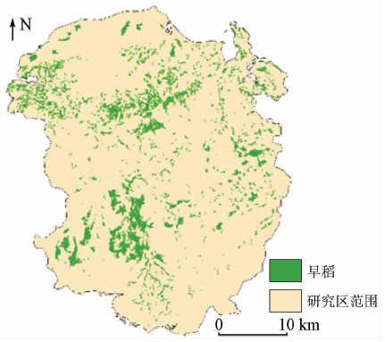
Abstract With the purpose of exploring the extraction of early paddy rice area distribution information from bipolar Sentinel-1A Radar image data recognition and on the basis of an analysis of backscattering coefficients of typical terrain objects, the authors employed the idea that polarization differential SAR images and polarization ratio SAR images play an important role in the classification of typical terrain objects and proposed the utilization of the normalized parameters of water body. Then, the support vector machine (SVM) classification method and the threshold classification method were used to extract the area of early paddy rice from the normalized polarimetric SAR data of single-phase and multi-temporal water body on March 10, March 22, April 3, April 15 and 15 April 15 in 2017. The results show that the threshold classification method is better than the SVM classification method. The overall accuracy of the former method is 89.01%, Kappa coefficient is 0.823 1, mapping accuracy and user accuracy of early paddy rice are 92.68% and 82.26%, respectively. The planting area is 129,000 hectares, which is basically consistent with the spatial distribution of the main early paddy rice production bases in Lingao County. It can be concluded that multi-parameter polarimetric SAR data can improve the accuracy of recognition and extraction of terrain objects. The best monitoring data for extracting early paddy rice area are multi-temporal NDVH polarimetric SAR data.
|
| Keywords
early paddy rice area
Sentinel-1A
backscatter coefficient
normalized parameters of water body
|
|
|
|
Corresponding Authors:
Hongzhong LI
E-mail: hz.li@siat.ac.cn
|
|
Issue Date: 14 March 2020
|
|
|
| [1] |
吴炳方 . 中国农情遥感速报系统[J]. 遥感学报, 2004,8(6):481-497.
|
| [1] |
Wu B F . China crop watch system with remote sensing[J]. Journal of Remote Sensing, 2004,8(6):481-497.
|
| [2] |
邵芸, 郭华东, 范湘涛 , 等. 水稻时域散射特征分析及其应用研究[J]. 遥感学报, 2001,5(5):340-345.
|
| [2] |
Shao Y, Guo H D, Fan X T , et al. Studies on rice backscatter signatures in time domain and its applications[J]. Journal of Remote Sensing, 2001,5(5):340-345.
|
| [3] |
刘浩, 邵芸, 王翠珍 , 等. 多时相RADARSAT数据在广东肇庆地区稻田分类中的应用[J]. 国土资源遥感, 1997,9(4):1-6,13.doi: 10.6046/gtzyyg.1997.04.01.
|
| [3] |
Liu H, Shao Y, Wang C Z , et al. The application of muti-temopral RADARSAT data to paddy field classification in Zhaoqing area,Guangdong Province,China[J]. Remote Sensing for Land and Resources, 1997,9(4):1-6,13.doi: 10.6046/gtzyyg.1997.04.01.
|
| [4] |
杨沈斌, 李秉柏, 申双和 , 等. 基于多时相多极化差值图的稻田识别研究[J]. 遥感学报, 2008,12(4):613-619.
|
| [4] |
Yang S B, Li B B, Shen S H , et al. Rice mapping research based on multi-temporal,multi-polarization backscattering differences[J]. Journal of Remote Sensing, 2008,12(4):613-619.
|
| [5] |
国贤玉, 李坤, 王志勇 , 等. 基于SVM+SFS策略的多时相紧致极化SAR水稻精细分类[J]. 国土资源遥感, 2018,30(4):20-27.doi: 10.6046/gtzyyg.2018.04.04.
|
| [5] |
Guo X Y, Li K, Wang Z Y , et al. Fine classification of rice with multi-temporal compact polarimetric SAR based on SVM + SFS strategy[J]. Remote Sensing for Land and Resources, 2018,30(4):20-27.doi: 10.6046/gtzyyg.2018.04.04.
|
| [6] |
王迪, 周清波, 陈仲新 , 等. 基于合成孔径雷达的农作物识别研究进展[J]. 农业工程学报, 2014,30(16):203-212.
|
| [6] |
Wang D, Zhou Q B, Chen Z X , et al. Research advances on crop identification using synthetic aperture Radar[J]. Transactions of the Chinese Society of Agricultural Engineering, 2014,30(16):203-212.
|
| [7] |
严小微, 岑新杰, 唐清杰 , 等. 海南省西北部临高及周边地区早造杂交水稻制种适宜播种期研究[J]. 杂交水稻, 2016,31(5):25-27.
|
| [7] |
Yan X W, Cen X J, Tang Q J , et al. Studies on suitable sowing time for hybrid rice seed production in the early-cropping season in Lingao County and its surrounding area in northwestern Hainan[J]. Hybrid Rice, 2016,31(5):25-27.
|
| [8] |
化国强, 李晨, 杨沈斌 , 等. 利用RADARSAT-2数据基于比值检测的水稻制图[J]. 江苏农业学报, 2012,28(6):1451-1458.
|
| [8] |
Hua G Q, Li C, Yang S B , et al. Rice mapping based on ratio method using RADARSAT-2 SAR data[J]. Jiangsu Journal of Agricultural Sciences, 2012,28(6):1451-1458.
|
| [9] |
李俐, 孔庆玲, 王鹏新 , 等. 基于时间序列Sentinel-1A数据的玉米种植面积监测研究[J]. 资源科学, 2018,40(8):1608-1621.
|
| [9] |
Li L, Kong Q L, Wang P X , et al. Monitoring of maize planting area based on time-series Sentinel-1A SAR data[J]. Resources Science, 2018,40(8):1608-1621.
|
| [10] |
周北燕 . 中国分省系列地图册:海南省地图册[M/CD]. 北京: 中国地图出版社, 2017: 76-79.
|
| [10] |
Zhou B Y. China Provincial Atlas Series:Atlas of Hainan[M/CD]. Beijing: China Cartographic Publishing House, 2017: 76-79.
|
| [11] |
杨魁, 杨建兵, 江冰茹 . Sentinel-1卫星综述[J]. 城市勘测, 2015(2):24-27.
|
| [11] |
Yang K, Yang J B, Jiang B R . Sentinel-1 satellite overview[J]. Urban Geotechnical Investigation and Surveying, 2015(2):24-27.
|
| [12] |
韩东, 杨浩, 杨贵军 , 等. 基于Sentinel-1雷达影像的玉米倒伏监测模型[J]. 农业工程学报, 2018,34(3):166-172.
|
| [12] |
Han D, Yang H, Yang G J , et al. Monitoring model of maize lodging based on Sentinel-1 Radar image[J]. Transactions of the Chinese Society of Agricultural Engineering, 2018,34(3):166-172.
|
| [13] |
陈劲松, 林珲, 邵芸 . 微波遥感农业应用研究——水稻生长监测[M]. 北京: 科学出版社, 2010: 82-95.
|
| [13] |
Chen J S, Lin H, Shao Y. Application of Microwave Remote Sensing in Agriculture:Paddy Rice Growth Monitoring[M]. Beijing: Science Press, 2010: 82-95.
|
| [14] |
张猛, 曾永年 . 基于多时相Landsat数据融合的洞庭湖区水稻面积提取[J]. 农业工程学报, 2015,31(13):178-185.
|
| [14] |
Zhang M, Zeng Y N . Mapping paddy fields of Dongting Lake area by fusing Landsat and MODIS data[J]. Transactions of the Chinese Society of Agricultural Engineering, 2015,31(13):178-185.
|
| [15] |
邵芸, 廖静娟, 范湘涛 , 等. 水稻时域后向散射特性分析:雷达卫星观测与模型模拟结果对比[J]. 遥感学报, 2002,6(6):440-450.
|
| [15] |
Shao Y, Liao J J, Fan X T , et al. Analysis on rice backscatter signatures in time domain:Comparison between RADARSAT-SAR observation and simulated model results[J]. Journal of Remote Sensing, 2002,6(6):440-450.
|
| [16] |
Richards J A, Jia X P . Remote Sensing Digital Image Analysis[M]. Berlin:Springer-Verlag, 1999.
|
| [17] |
Loosvelt L, Peters J, Skriver H , et al. Random forests as a tool for estimating uncertainty at pixel-level in SAR image classification[J]. International Journal of Applied Earth Observations and Geoinformation, 2012,19(1):173-184.
|
| [18] |
李楠, 朱秀芳, 潘耀忠 , 等. 人工蜂群算法优化的SVM遥感影像分类[J]. 遥感学报, 2018,22(4):559-569.
|
| [18] |
Li N, Zhu X F, Pan Y Z , et al. Optimized SVM based on artificial bee colony algorithm for remote sensing image classification[J]. Journal of Remote Sensing, 2018,22(4):559-569.
|
| [19] |
汪小钦, 王钦敏, 史晓明 , 等. 基于主成分变换的ASAR数据水稻种植面积提取[J]. 农业工程学报, 2008,24(10):122-126.
|
| [19] |
Wang X Q, Wang Q M, Shi X M , et al. Rice field mapping and monitoring using ASAR data based on principal component analysis[J]. Transactions of the Chinese Society of Agricultural Engineering, 2008,24(10):122-126.
|
| [20] |
孔金玲, 李菁菁, 甄珮珮 , 等. 微波与光学遥感协同反演旱区地表土壤水分研究[J]. 地球信息科学学报, 2016,18(6):857-863.
|
| [20] |
Kong J L, Li J J, Zhen P P , et al. Inversion of soil moisture in arid area based on microwave and optical remote sensing data[J]. Journal of Geo-Information Science, 2016,18(6):857-863.
|
|
Viewed |
|
|
|
Full text
|
|
|
|
|
Abstract
|
|
|
|
|
Cited |
|
|
|
|
| |
Shared |
|
|
|
|
| |
Discussed |
|
|
|
|
 2020,
Vol. 32
2020,
Vol. 32