|
|
 |
|

|
|
|
Expansion monitoring of construction land based on SAR time series: A case study of Xinbei District, Changzhou |
SUN Chao1,2( ), CHEN Zhenjie1,2(), WANG Beibei1,2 ), CHEN Zhenjie1,2(), WANG Beibei1,2 |
1. School of Geography and Ocean Science, Nanjing University, Nanjing 210023, China
2. Key Laboratory for Satellite Mapping Technology and Applications of National Administration of Surveying, Mapping and Geoinformation, Nanjing 210023, China |
|
|
|
|
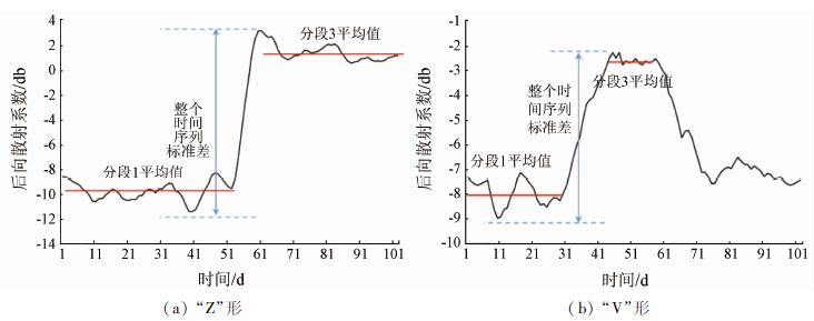
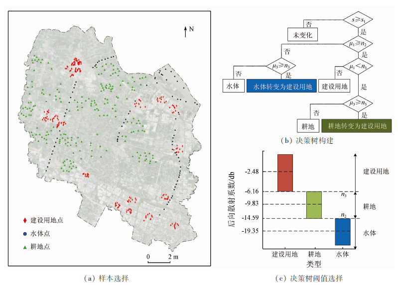
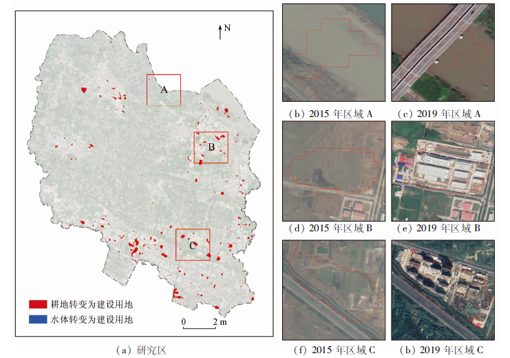
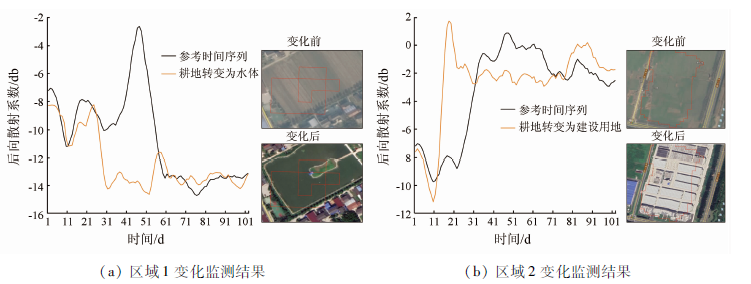
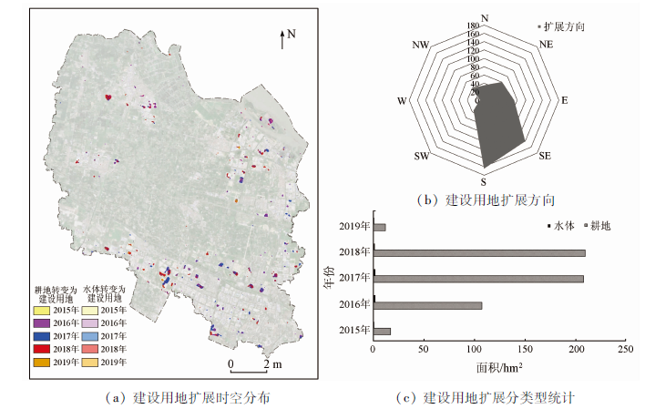
Abstract With the acceleration of urbanization process, the size of the city is growing, and hence it is of great importance to grasp the change of construction land quickly and accurately for the sustainable development of cities. Because SAR images are not affected by the weather, it is possible to use SAR time series to study the expansion of construction land. There are two kinds of time series structures in SAR, which are named “Z” structure and “V” structure in this paper. In view of the previous studies that only consider the “Z” structure but not the “V” structure, this study proposes a construction land extension method based on time series adaptive segmentation. The original time series is segmented in an adaptive manner, the average value of the segments is used as the characteristic value, and the extended area of construction land is extracted by the decision tree. The accuracy and completeness of the method are 89.60% and 92.73% respectively. The results are as follows: ① The method proposed in this paper can effectively monitor the expansion of construction land. Compared with that of the dynamic time warping(DTW) method, the accuracy is increased by 1.80 percentage points and the integrity rate is increased by 1.27 percentage points. ② From 2015 to 2019, construction land in Xinbei District of Changzhou increased by 557.96 hectares, mainly in the south and the southeast.
|
| Keywords
construction land expansion
SAR time series
Sentinel-1A
time series segment
sequential morphological structure
|
|
|
|
Corresponding Authors:
CHEN Zhenjie
E-mail: 18256021764@163.com;chenzj@nju.edu.cn
|
|
Issue Date: 23 December 2020
|
|
|
| [1] |
Cui X G, Fang C L, Liu H M, et al. Assessing sustainability of urbanization by a coordinated development index for an urbanization-resources-environment complex system:A case study of Jing-Jin-Ji region,China[J]. Ecological Indicators, 2019,96:383-391.
doi: 10.1016/j.ecolind.2018.09.009
url: https://linkinghub.elsevier.com/retrieve/pii/S1470160X18306848
|
| [2] |
Savage A M, Hackett B, Guenard B, et al. Fine-scale heterogeneity across Manhattan’s urban habitat mosaic is associated with variation in ant composition and richness[J]. Insect Conservation and Diversity, 2015,8(3):216-228.
doi: 10.1111/icad.2015.8.issue-3
url: http://doi.wiley.com/10.1111/icad.2015.8.issue-3
|
| [3] |
Fang C L, Liu H M, Li G D, et al. Estimating the impact of urbanization on air quality in China using spatial regression models[J]. Sustainability, 2015,7(11):15570-15592.
doi: 10.3390/su71115570
url: http://www.mdpi.com/2071-1050/7/11/15570
|
| [4] |
Feng T T, Zhao J Q. Review and comparison:Building extraction methods using high-resolution images[C]// Proceedings of the 2009 Second International Symposium on Information Science and Engineering. IEEE, 2009.
|
| [5] |
Soh M B C. Crime and urbanization:Revisited Malaysian case[J]. Procedia-Social and Behavioral Sciences, 2012,42:291-299.
doi: 10.1016/j.sbspro.2012.04.193
url: https://linkinghub.elsevier.com/retrieve/pii/S1877042812010750
|
| [6] |
Wang B, Chen Z, Zhu A, et al. Multi-level classification based on trajectory features of time series for monitoring impervious surface expansions[J]. Remote Sensing, 2019,11(6):640.
|
| [7] |
刘警鉴, 李洪忠, 华璀, 等. 基于Sentinel-1A数据的临高县早稻面积提取[J]. 国土资源遥感, 2020,32(1):191-199.doi: 10.6046/gtzyyg.2020.01.26.
|
| [7] |
Liu J J, Li H Z, Hua C, et al. Extration of early paddy rice area in Lingao County based on Sentinel-1A data[J]. Remote Sensing for Land and Resources, 2020,32(1):191-199.doi: 10.6046/gtzyyg.2020.01.26.
|
| [8] |
王世新, 田野, 周艺, 等. 基于后向散射模型的多极化SAR影像建筑物高度提取[J]. 国土资源遥感, 2017,29(2):37-45.doi: 10.6046/gtzyyg.2017.02.06.
|
| [8] |
Wang S X, Tian Y, Zhou Y, et al. Building heigh extration from multi-polarization SAR imagery based on backscattering model[J]. Remote Sensing for Land and Resources, 2017,29(2):37-45.doi: 10.6046/gtzyyg.2017.02.06.
|
| [9] |
Ban Y, Yousif O A. Multitemporal spaceborne SAR data for urban change detection in China[J]. IEEE Journal of Selected Topics in Applied Earth Observations and Remote Sensing, 2012,5(4):1087-1094.
|
| [10] |
Yousif O, Ban Y. Improving urban change detection from multitemporal SAR images using PCA-NLM[J]. IEEE Transactions on Geoscience and Remote Sensing, 2013,51(4):2032-2041.
doi: 10.1109/TGRS.2013.2245900
url: http://dx.doi.org/10.1109/TGRS.2013.2245900
|
| [11] |
易凤佳, 李仁东, 常变蓉, 等. 长株潭地区建设用地扩张遥感时空特征分析[J]. 国土资源遥感, 2015,27(2):160-166.doi: 10.6046/gtzyyg.2015.02.25.
doi: 10.6046/gtzyyg.2015.02.25
url: http://www.gtzyyg.com/CN/abstract/abstract1874.shtml
|
| [11] |
Yi F J, Li R D, Chang B R, et al. Spatial-temporal features of construction land expansion in Changzhutan (Changsha-Zhuzhou-Xiangtan) area based on remote sensing[J]. Remote Sensing for Land and Resources, 2015,27(2):160-166.doi: 10.6046/gtzyyg.2015.02.25.
|
| [12] |
郭晶鹏, 赵映慧, 谌慧倩, 等. 黑龙江工业城市建设用地时空扩张遥感监测[J]. 国土资源遥感, 2018,30(3):204-212. doi: 10.6046/gtzyyg.2018.03.28.
|
| [12] |
Guo J P, Zhao Y H, Chen H Q, et al. Remote sensing monitoring for temporal and spatial expansion of construction land of industrial cities in Heilongjiang[J]. Remote Sensing for Land and Resources, 2018,30(3):204-212.doi: 10.6046/gtzyyg.2018.03.28.
|
| [13] |
Qi Z X, Yeh A G-O, Li X, et al. Monthly short-term detection of land development using RADARSAT-2 polarimetric SAR imagery[J]. Remote Sensing of Environment, 2015,164:179-196.
doi: 10.1016/j.rse.2015.04.018
url: https://linkinghub.elsevier.com/retrieve/pii/S0034425715001601
|
| [14] |
Walter V. Object-based classification of remote sensing data for change detection[J]. ISPRS Journal of Photogrammetry and Remote Sensing, 2004,58(3-4):225-38.
doi: 10.1016/j.isprsjprs.2003.09.007
url: https://linkinghub.elsevier.com/retrieve/pii/S0924271603000595
|
| [15] |
Im J, Jensen J R. A change detection model based on neighborhood correlation image analysis and decision tree classification[J]. Remote Sensing of Environment, 2005,99(3):326-340.
doi: 10.1016/j.rse.2005.09.008
url: https://linkinghub.elsevier.com/retrieve/pii/S0034425705002919
|
| [16] |
Wang W, Chen Z, Li X, et al. Detecting spatio-temporal and typological changes in land use from Landsat image time series[J]. Journal of Applied Remote Sensing, 2017,11(3):035006.
doi: 10.1117/1.JRS.11.035006
url: http://remotesensing.spiedigitallibrary.org/article.aspx?doi=10.1117/1.JRS.11.035006
|
| [17] |
Wang Y F, Zhao F F, Cheng L, et al. Framework for monitoring the conversion of cultivated land to construction land using SAR image time series[J]. Remote Sensing Letters, 2015,6(10):794-803.
doi: 10.1080/2150704X.2015.1081304
url: http://www.tandfonline.com/doi/full/10.1080/2150704X.2015.1081304
|
| [18] |
Li S, Wang Y F, Chen P P, et al. Spatiotemporal fuzzy clustering strategy for urban expansion monitoring based on time series of pixel-level optical and SAR images[J]. IEEE Journal of Selected Topics in Applied Earth Observations and Remote Sensing, 2017,10(5):1769-1779.
doi: 10.1109/JSTARS.2017.2657607
url: http://ieeexplore.ieee.org/document/7858716/
|
| [19] |
Feng H, Zhang L, Liao M. Building change detection using coherent and incoherent features from multitemporal SAR images[C]// Proceedings of the 2019 10th International Workshop on the Analysis of Multitemporal Remote Sensing Images (MultiTemp). IEEE, 2019.
|
| [20] |
车美琴, 阿里木·赛买提, 杜培军, 等. 利用旋转不变特征提取全极化SAR影像人工地物[J]. 遥感学报, 2016,20(2):303-314.
|
| [20] |
Che M Q, Samat A, Du P J, et al. Urban man-made target extraction from Quad-PolSAR imagery with roll invariant parameters[J]. Journal of Remote Sensing, 2016,20(2):303-314.
|
| [21] |
周大镯, 李敏强. 基于序列重要点的时间序列分割[J]. 计算机工程, 2008,34(23):14-16.
|
| [21] |
Zhou D Z, Li M Q. Time series segmentation based on series importance point[J]. Computer Engineering, 2008,34(23):14-16.
|
|
Viewed |
|
|
|
Full text
|
|
|
|
|
Abstract
|
|
|
|
|
Cited |
|
|
|
|
| |
Shared |
|
|
|
|
| |
Discussed |
|
|
|
|
 2020,
Vol. 32
2020,
Vol. 32