|
|
|
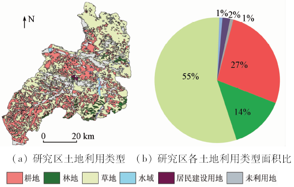
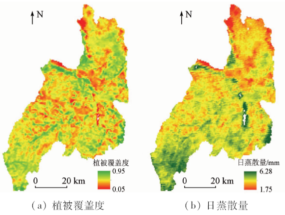
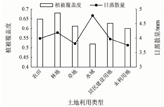
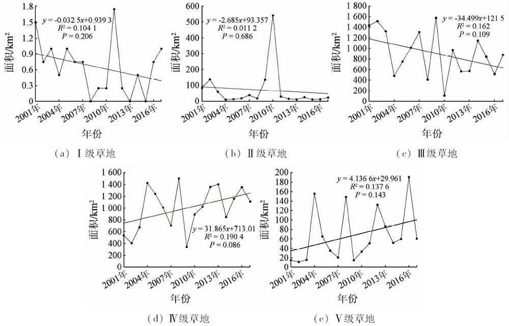
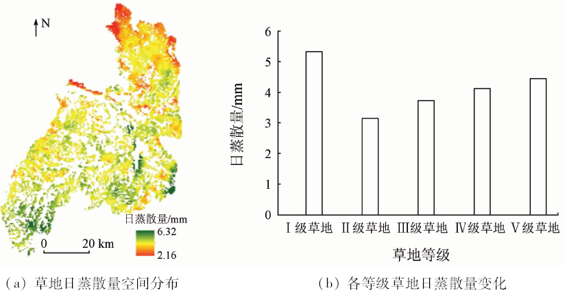
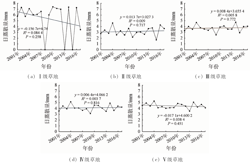
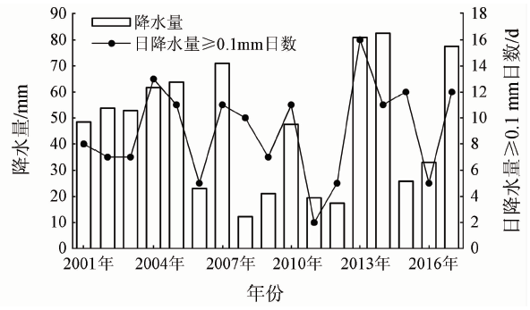
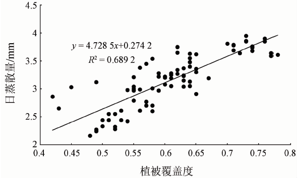
Abstract Studying the changes of evapotranspiration of degraded grassland in Inner Mongolia is conducive to understanding the water cycle of the degraded grassland ecosystem in this region and provides an important basis for the rational use of grassland water resources in this region. In this study, Duolun County in Inner Mongolia was taken as the research object. MODIS data during the flourishing period from 2001 to 2017 were used to invert the spatial distribution and variation of vegetation coverage and daily evapotranspiration in this region for nearly 17 years, and the effects of land use and grassland degradation on evapotranspiration were analyzed. Some conclusions have been reached: ① The order of vegetation coverage of different land use types is forest land >farmland>residential construction land>grassland>unused land>water area; the order of daily evapotranspiration of different land use types is water area>forest land>farmland >residential construction land>grassland>unused land. ② From 2001 to 2017, the grassland types in Duolun County are mainly of the III and IV grades; the area of low-grade grassland has a downward trend, while the area of high-quality grassland has an upward trend, which indicates that the protective measures for grassland in this area achieved certain results. ③ During 2001-2017, there was no obvious change trend in the daily evapotranspiration of all grassland grades; except for a few years, vegetation coverage and daily evapotranspiration showed consistent interannual fluctuations. ④ According to the spatial and temporal distribution pattern of vegetation coverage and daily evapotranspiration, it is concluded that there is a positive correlation between vegetation coverage and daily evapotranspiration.
|
| Keywords
MODIS
grassland grade
vegetation coverage
SEBEL model
daily evapotranspiration
|
|
|
|
Corresponding Authors:
Chengfu ZHANG
E-mail: 2651534893@qq.com
|
|
Issue Date: 14 March 2020
|
|
|
| [1] |
刘起 . 内蒙古草地资源与生态环境[J]. 内蒙古环境保护, 1998(2):16-18.
|
| [1] |
Liu Q . Inner Mongolia grassland resurces and ecological-environment[J]. Environment Protection of Inner Mongolia, 1998(2):16-18.
|
| [2] |
肖洋, 欧阳志云, 王莉雁 , 等. 内蒙古生态系统质量空间特征及其驱动力[J]. 生态学报, 2016,36(19):6019-6030.
|
| [2] |
Xiao Y, Ouyang Z Y, Wang L Y , et al. Spatial patterns of ecosystem quality in Inner Mongolia and its driving forces analysis[J]. Acta Ecologica Sinica, 2016,36(19):6019-6030.
|
| [3] |
萨其日拉 . 内蒙古阿鲁科尔沁旗草地退化时空分布特征分析[D]. 内蒙古:内蒙古师范大学, 2017.
|
| [3] |
Saqirila . Analysis of Temporal and Spatial Distribution Characteristics of Grassland Degradation Arhorqin Banner,Inner Mongolia[D]. Inner Mongolia: Inner Mongolia Normal University, 2017.
|
| [4] |
王改莲, 庞云, 陈景芋 , 等. 浅析内蒙古草地现状、退化成因及发展建议[J]. 内蒙古农业科技, 2011(2): 3, 21.
|
| [4] |
Wang G L, Pang Y, Chen J Y , et al. The current situation, degradation causes of grassland in Inner Mongolia and its development proposal[J]. Inner Mongolia Agricultural Science And Technology, 2011(2): 3, 21.
|
| [5] |
李凤霞, 张德罡 . 草地退化指标及恢复措施[J]. 草原与草坪, 2005(1):24-28.
|
| [5] |
Li F X, Zhang D G . Indicators and recovery approaches of degenerated grassland in China[J]. Grassland and Turf, 2005(1):24-28.
|
| [6] |
金荣 . 退化草地恢复研究进展[J]. 内蒙古林业调查设计, 2018,41(5):61-64.
|
| [6] |
Jin R . Progress in research on restoration of degraded grassland[J]. Inner Mongolia Forestry Investigation and Design, 2018,41(5):61-64.
|
| [7] |
梁四海, 陈江, 金晓媚 , 等. 近21年青藏高原植被覆盖变化规律[J]. 地球科学进展, 2007(1):33-40.
|
| [7] |
Liang S H, Chen J, Jin X M , et al. Regularity of vegetation coverage changes in the Tibetan Plateau over the last 21 years[J]. Advances in Earth Science, 2007(1):33-40.
|
| [8] |
陈祖刚, 巴图娜存, 徐芝英 , 等. 基于数码相机的草地植被盖度测量方法对比研究[J]. 草业学报, 2014,23(6):20-27.
|
| [8] |
Chen Z G, Batu N C, Xu Z Y , et al. Measuring grassland vegetation cover using digital images[J]. Acta Prataculturae Sinica, 2014,23(6):20-27.
|
| [9] |
穆少杰, 李建龙, 陈奕兆 , 等. 2001—2010年内蒙古植被覆盖度时空变化特征[J]. 地理学报, 2012,67(9):1255-1268.
|
| [9] |
Mu S J, Li J L, Chen Y Z , et al. Spatial differences of variations of vegetation coverage in Inner Mongolia during 2001—2010[J]. Acta Geographica Sinica, 2012,67(9):1255-1268.
|
| [10] |
曹旭娟 . 青藏高原草地退化及其对气候变化的响应[D]. 北京:中国农业科学院, 2017.
|
| [10] |
Cao X J . Grassland Degradation and Its Response to Climate Change in the Qinghai-Tibet Plateau[D]. Beijing:Chinese Academy of Agricultural Sciences, 2017.
|
| [11] |
李婧梅, 蔡海, 程茜 , 等. 青海省三江源地区退化草地蒸散特征[J]. 草业学报, 2012,21(3):223-233.
|
| [11] |
Li J M, Cai H, Cheng Q , et al. Characterizing the evapotranspiration of a degraded grassland in the Sanjiangyuan Region of Qinghai Province[J]. Acta Prat-Aculturae Sinica, 2012,21(3):223-233.
|
| [12] |
张立锋, 张继群, 张翔 , 等. 三江源区退化高寒草甸蒸散的变化特征[J]. 草地学报, 2017,25(2):273-281.
|
| [12] |
Zhang L F, Zhang J Q, Zhang X , et al. Characteristics of evapotranspiration of degraded alpine meadow in the Three-River Source Region[J]. Acta Agrestia Sinca, 2017,25(2):273-281.
|
| [13] |
郑涵, 王秋凤, 李英年 , 等. 海北高寒灌丛草甸蒸散量特征[J]. 应用生态学报, 2013,24(11):3221-3228.
|
| [13] |
Zheng H, Wang Q F, Li Y N , et al. Characteristics of evapotranspiration in an alpine shrub meadow in Haibei,Qinghai of Northwest China[J]. Chinese Journal of Applied Ecology, 2013,24(11):3221-3228.
|
| [14] |
刘可, 杜灵通, 侯静 , 等. 2000—2014年宁夏草地蒸散时空特征及演变规律[J]. 草业学报, 2018,27(3):1-12.
|
| [14] |
Liu K, Du L T, Hou J , et al. Spatio-temporal characteristics and evolution of evapotranspiration of natural grassland in Ningxia during 2000—2014[J]. Acta Prataculturae Sinica, 2018,27(3):1-12.
|
| [15] |
闫俊杰, 吕光辉, 徐海量 , 等. 2000—2014年塔里木河干流的植被覆盖与蒸散发时空变化及其关系[J]. 水土保持通报, 2018,38(3):248-255.
|
| [15] |
Yan J J, Lyu G H, Xu H L , et al. Spatial-temporal variations in vegetation cover and evapotranspiration and their relationship in Tarim River during 2000—2014[J]. Bulletin of Soil and Water Conservation, 2018,38(3):248-255.
|
| [16] |
Bastiaanssen W G M . SEBAL-based sensible and latent heat fluxes in the irrigated Gediz Basin,Turkey[J]. Journal of Hydrology, 2000,229(1-2):87-100.
|
| [17] |
Wu C D, Cheng C C, Lo H C , et al. Application of SEBAL and Markov models for future stream flow simulation through remote sensing[J]. Water Resources Management, 2010,24(14):3773-3797.
|
| [18] |
王霞 . 基于SEBAL模型的极端干旱气候区域蒸散发的遥感估算[D]. 乌鲁木齐:新疆农业大学, 2012.
|
| [18] |
Wang X . Study on Regional Evapotranspiration Estimation Using Remote Sensing Technology of Extreme Arid Climate Area Based on SEBAL[J]. Urumqi:Xinjiang Agricultural University, 2012.
|
| [19] |
Tang R L, Li Z L, Chen K S . Spatial-scale effect on the SEBAL model for evapotranspiration estimation using remote sensing data[J]. Agricultural and Forest Meteorology, 2013: 174-175.
|
| [20] |
安乐生, 朱磊, 刘春 . 基于SEBAL模型的不同覆被条件下区域蒸散发研究[J]. 安庆师范学院学报(自然科学版), 2016,22(3):97-101.
|
| [20] |
An L S, Zhu L, Liu C . Research on regional evapotranspiration based on SEBAL model of different vegetation cover[J]. Journal of Anqing Teachers College(Natural Science Edition), 2016,22(3):97-101.
|
| [21] |
阿布都沙拉木·吐鲁甫, 买买提·沙吾提, 马春玥 , 等. 基于SEBAL模型的渭—库绿洲蒸散量特征及影响因子研究[J]. 地球信息科学学报, 2018,20(09):1361-1372.
|
| [21] |
Abdusalam T, Mamat S, Ma C Y , et al. Characteristics and impact factors of evapotranspiration in Ugan and Kuqa Rivers delta oasis based on SEBAL model[J]. Journal of Geo- Information Science, 2018,20(9):1361-1372.
|
| [22] |
阿如旱, 车敏 . 近60年多伦县气候特征变化分析[J]. 内蒙古师范大学学报(自然科学版), 2017,46(3):426-430.
|
| [22] |
Aruhan, Che M . Analysis on the characteristics of climate change in recent 60 years in Duolun County,Inner Mongolia[J]. Journal of Inner Mongolia Normal University(Natural Science Edition), 2017,46(3):426-430.
|
| [23] |
胡小龙 . 内蒙古多伦县退化草地生态恢复研究[D]. 北京:北京林业大学, 2011.
|
| [23] |
Hu X L . Study on Ecological Restoration of Degraded Grassland in Duolun County[D]. Beijing:Beijing Forestry University, 2011.
|
| [24] |
陈贵廷, 刘清泉, 徐甫生 , 等. 基于3S技术的多伦县植被覆盖度动态变化研究[J]. 内蒙古林业科技, 2009,35(4):47-49.
|
| [24] |
Chen G T, Liu Q Q, Xu F S , et al. Dynamic change of vegetation coverage based on 3S technologyin Duolun County[J]. Journal of Inner Mongolia Forestry Science and Technology, 2009,35(4):47-49.
|
| [25] |
苏江 . 基于3S技术的多伦县林业工程生态效益评价[D]. 呼和浩特:内蒙古农业大学, 2011.
|
| [25] |
Su J . Based on 3S to Evaluate Effect of Forestry Project in Duolun Country[D]. Hohhot:Inner Mongolia Agricultural University, 2011.
|
| [26] |
张连根, 周佳宁, 刘佳 , 等. 多伦县植被覆盖空间格局及动态变化研究[J]. 内蒙古林业科技, 2016,42(1):13-16.
|
| [26] |
Zhang L G, Zhou J N, Liu J , et al. Study on spatial pattern of vegetation cover and dynamic changes in Duolun County[J]. Journal of Inner Mongolia Forestry Science and Technology, 2016,42(1):13-16.
|
| [27] |
Bastiaanssen W G M, Menenti M, Feddes R A , et al. A remote sensing surface energy balance algorithm for land(SEBAL).1.Formulation[J]. Journal of Hydrology, 1998(212-213):198-212.
|
| [28] |
高海东, 李占斌, 贾莲莲 , 等. 利用SEBAL模型估算不同水土保持措施下的流域蒸腾蒸发量——以韭园沟、裴家峁流域为例[J]. 土壤学报, 2012,49(2):260-268.
|
| [28] |
Gao H D, Li Z B, Jia L L , et al. Estimation of evapotranspirations from watersheds under diffrent and soil conservation measures using SEBAL model:A case study of Jiuyuangou and Peijiamao[J]. Acta Pedologica Sinica, 2012,49(2):260-268.
|
| [29] |
张惠平 . 基于MODIS数据的淮河流域蒸散发估算研究[D]. 西安:西安科技大学, 2017.
|
| [29] |
Zhang H P . Estimation of Evapotranspiration Based on MODIS Data in Huaihe River Basin[D]. Xi’an:Xi’an University of Science and Technology, 2017.
|
| [30] |
余弘婧, 李晓兵, 赵勇 , 等. 基于SEBAL模型的锡林浩特蒸散量反演研究[J]. 中国水利水电科学研究院学报, 2013,11(4):266-273.
|
| [30] |
Yu H J, Li X B, Zhao Y , et al. Retrieving evapotranspiration in Xilinhot based on SEBAL model[J]. Journal of China Instituteof Water Resources and Hydropower Research, 2013,11(4):266-273.
|
| [31] |
范建忠, 李登科, 高茂盛 . 基于MOD16的陕西省蒸散量时空分布特征[J]. 生态环境学报, 2014,23(9):1536-1543.
|
| [31] |
Fan J Z, Li D K, Gao M S . Spatio-temporal variations of evapotranspiration in Shaanxi Province using MOD16 products[J]. Ecology and Environmental Sciences, 2014,23(9):1536-1543.
|
| [32] |
蔺文静, 董华, 陈立 , 等. 基于SEBAL模型的区域蒸发蒸腾遥感估算[J]. 遥感信息, 2008(5):50-54.
|
| [32] |
Lin W J, Dong H, Chen L , et al. SEBAL based regional evapotranspiration estimation[J]. Remote Sensing Information, 2008(5):50-54.
|
| [33] |
达日玛 . 基于MODIS数据的区域蒸散发量遥感估算及其应用[D]. 呼和浩特:内蒙古师范大学, 2010.
|
| [33] |
Darima . A Study on Regional Evaportranspiration Estimation of Remote Sensing and Its Application Based on MODIS Data Acase of Bayannaoer City[D]. Hohhot:Inner Mongolia Normal University, 2010.
|
| [34] |
李兴华, 魏玉荣, 张存厚 . 内蒙古草地面积的变化及其成因分析——以锡林郭勒盟多伦县为例[J]. 草业科学, 2012,29(1):19-24.
|
| [34] |
Li X H, Wei Y R, Zhang C H . Vraiation of grassland area and its cause in Inner Mongolia:A case study on Duolun County of Xilin Gol League[J]. Pratacultural Science, 2012,29(1):19-24.
|
| [35] |
张巧凤, 刘桂香, 于红博 , 等. 基于MOD16A2的锡林郭勒草原近14年的蒸散发时空动态[J]. 草地学报, 2016,24(2):286-293.
|
| [35] |
Zhang Q F, Liu G X, Yu H B , et al. Temporal and spatial dynamic of ET based on MOD16A2 in recent fourteen years in Xilingol Steppe[J]. Acta Agrestia Sinca, 2016,24(2):286-293.
|
| [36] |
云文丽, 侯琼, 王永利 , 等. 内蒙古典型草原作物系数和实际蒸散量的时空分布特征[J]. 自然资源学报, 2013,28(2):300-311.
|
| [36] |
Yun W L, Hou Q, Wang Y L , et al. Spatial and temporal distribution of crop coefficient and actual evapotranspiration in steppe of Inner Mongolia[J]. Journnal of Natural Resources, 2013,28(2):300-311.
|
|
Viewed |
|
|
|
Full text
|
|
|
|
|
Abstract
|
|
|
|
|
Cited |
|
|
|
|
| |
Shared |
|
|
|
|
| |
Discussed |
|
|
|
|
 2020,
Vol. 32
2020,
Vol. 32
 )
)