|
|
 |
|

|
|
|
Robust bundle adjustment for UAV images |
| Wu XUE1, Ling ZHAO2, Ying YU3 |
1. Space Security Research Center, Space Engineering University, Beijing 101416, China
2. 91039 Troops, Beijing 102400, China
3. School of Geospatial Information, Information Engineering University, Zhengzhou 450001, China |
|
|
|
|
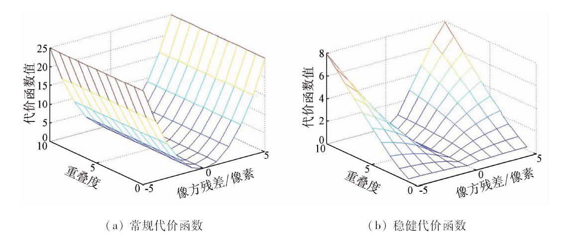
Abstract Aimed at tackling the problems that there are many mismatched points in the bundle adjustment of unmanned aerial vehicle (UAV) images, the variance loss function may cause the distortion of the solution parameters, and there exists large deviation from the true value which even causes impossibility of converge, the authors applied a robust bundle adjustment method considering the reliability of the observation value. This method uses loss function as a strategy to suppress gross errors, and is a variant designed on the basis of Cauchy loss function. The main idea of this method is adjusting the total loss function adaptively according to the mean value and variance of overlap degree and the residual of feature points, so as to overcome the influence of mismatched points on the computation of image parameters. Correspondingly, a practical accuracy evaluation method independent of ground control point (GCP) was designed. Experiments show that the method can still get robust adjustment results with high mismatch rate, and hence it is practical.
|
| Keywords
UAV image
mismatch points
robust
loss function
|
|
|
|
Issue Date: 18 June 2020
|
|
|
| [1] |
Colomina I, Molina P. Unmanned aerial systems for photogrammetry and remote sensing:A review[J]. ISPRS Journal of Photogrammetry and Remote Sensing, 2014,92:79-97.
|
| [2] |
隋立芬, 宋力杰. 误差理论与测量平差基础[M]. 北京: 解放军出版社, 2004: 51-62.
|
| [2] |
Sui L F, Song L J. Error theory and measurement adjustment basis[M]. Beijing: PLA Press, 2004: 51-62.
|
| [3] |
雷玉珍, 李中伟, 钟凯, 等. 基于随机抽样一致算法的误匹配标志点校正方法[J]. 光学学报, 2013,33(3):1-8.
|
| [3] |
Lei Y Z, Li Z W, Zhong K, et al. Mismatching marked points correction method based on random sample consensus algorithm[J]. Acta Optica Sinca, 2013,33(3):1-8.
|
| [4] |
单小军, 唐娉. 图像匹配中误匹配点检测技术综述[J]. 计算机应用研究, 2015,32(9):2561-2564.
|
| [4] |
Shan X J, Tang P. Review of false matching points detection methods for image matching[J]. Application Research of Computers, 2015,32(9):2561-2564.
|
| [5] |
徐青, 吴寿虎, 朱述龙, 等. 近代摄影测量[M]. 北京: 解放军出版社, 2000: 29-35.
|
| [5] |
Xu Q, Wu S H, Zhu S L, et al. Modern photogrammetry[M]. Beijing: PLA Press, 2000: 29-35.
|
| [6] |
舒红, 史文中. 浅谈测量平差到空间数据分析的可靠性理论延伸[J]. 武汉大学学报(信息科学版), 2018,43(12):1989-1993.
|
| [6] |
Shu H, Shi W Z. Extension of reliability theory of surveying adjustment into spatial data analytics[J]. Geomatics and Information Science of Wuhan University, 2018,43(12):1989-1993.
|
| [7] |
张保明, 龚志辉, 郭海涛 . 摄影测量学[M]. 北京: 测绘出版社, 2008.
|
| [7] |
Zhang B M, Gong Z H, Guo H T. Photogrammetry[M]. Beijing:Surveying and Mapping Compilation, 2008.
|
| [8] |
李德仁, 袁修孝. 误差处理与可靠性理论[M]. 武汉: 武汉大学出版社, 2012.
|
| [8] |
Li D R, Yuan X X. Error processing and reliability theory[M]. Wuhan: Wuhan University Press, 2012.
|
| [9] |
Aravkin M, Styer Z, Moratto A, et al. Student’s trobust bundle adjustment algorithm [C]// International Conference on Image Processing, 2012: 1757-1760.
|
| [10] |
吴福朝 . 计算机视觉中的数学方法[M]. 北京: 科学出版社, 2008.
|
| [10] |
Wu F C. Mathematic method in computer vision[M]. Beijing:Science Preess, 2008.
|
| [11] |
Madsen K, Nielsen H B, Tingleff O. Methods for Non-Linear Least Squares Problems[M]. Copenhagen:[s.n.], 2004.
|
| [12] |
Moulon P, Monasse P, Marlet R. Adaptive structure from motion with a contrario model estimation [C]//Asian Conference on Computer Vision.Springer, 2012: 257-270.
|
| [13] |
薛武. 无人机影像定位优化技术研究[D]. 郑州:信息工程大学, 2017.
|
| [13] |
Xue W. Research on optimization technology of UAV images positioning[D]. Zhengzhou:Information Engineering University, 2017.
|
| [14] |
Talker L, Moses Y, Shimshoni I. Using spatial order to boost the elimination of incorrect feature matches [C]//Proceedings of the IEEE Conference on Computer Vision and Pattern Recognition.IEEE, 2016: 1809-1817.
|
| [15] |
Masiero A, Guarnieri A, Vettore A, et al. On the use of INS to improve feature matching[J]. The International Archives of Photogrammetry,Remote Sensing and Spatial Information Sciences, 2014,40(1):227.
|
| [16] |
Tsai C H, Lin Y C. An accelerated image matching technique for UAV orthoimage registration[J]. ISPRS Journal of Photogrammetry and Remote Sensing, 2017,128:130-145.
|
| [17] |
Google.Ceres Solver[EB/OL].[2019-06-21]. http://ceres-solver.org.
url: http://ceres-solver.org
|
| [18] |
Hartley R. 计算机视觉中的多视图几何[M]. 韦穗,等译.合肥:安徽大学出版社, 2002.
|
| [18] |
Hartley R. Multiple View Geometry in Computer Vision[M]. Translated by Wei S, et al,Hefei:Anhui University Press, 2002.
|
| [19] |
袁修孝, 陈时雨, 钟灿. 基于基础矩阵的倾斜航摄影像相对定向方法[J]. 武汉大学学报(信息科学版), 2016,41(8):995-1000.
|
| [19] |
Yuan X X, Chen S Y, Zhong C. Oblique aerial image relative orientation based on fundamental matrix[J]. Geomatics and Information Science of Wuhan University, 2016,41(8):995-1000.
|
| [20] |
耿则勋, 张保明, 范大昭 . 数字摄影测量学[M]. 北京: 测绘出版社, 2010.
|
| [20] |
Geng Z X, Zhang B M, Fan D Z. Digital photogrammetry[M]. Beijing:Surveying and Mapping Compilation, 2010.
|
|
Viewed |
|
|
|
Full text
|
|
|
|
|
Abstract
|
|
|
|
|
Cited |
|
|
|
|
| |
Shared |
|
|
|
|
| |
Discussed |
|
|
|
|
 2020,
Vol. 32
2020,
Vol. 32