|
|
|
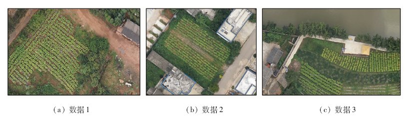
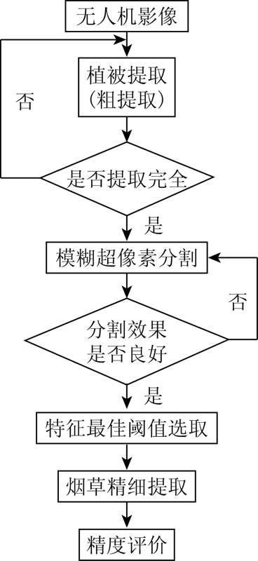
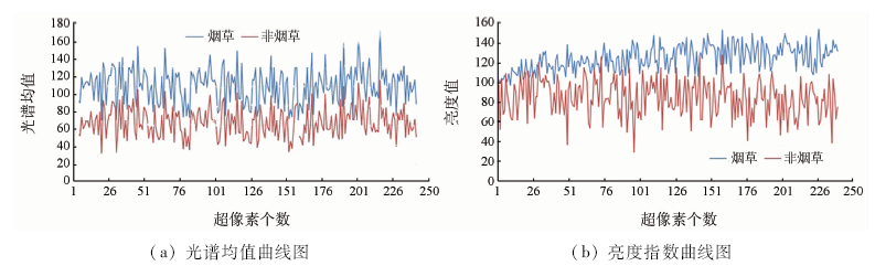
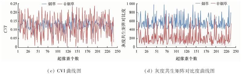
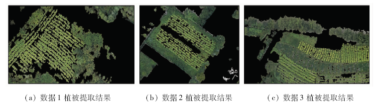
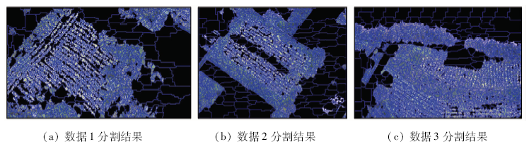
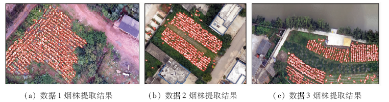
Abstract The successful extraction of tobacco single plant automation is of great significance to the realization of tobacco agricultural information, but there are still great difficulties in tobacco fine extraction. Therefore, a tobacco extraction method based on Fuzzy superpixels (FS) algorithm is proposed. Firstly, vegetation coverage area in UAV image is obtained by green space extraction method; secondly, super-pixel segmentation of image is carried out by using FS algorithm, and the mean value, brightness, shape index, aspect ratio, custom vegetation index and other features of super-pixel are counted; finally, the number of tobacco plants is extracted and counted by calculating the feature threshold of super-pixel. Three UAV images were selected as the experimental data. The experimental results show that the overall accuracy of this method is 84.28%, 89.05% and 82.97% respectively. This method can be used for automatic extraction of tobacco plant and can provide effective reference for later calculation of tobacco yield.
|
| Keywords
tobacco
UAV image
fuzzy-superpixel segmentation
information extraction
|
|
|
|
Corresponding Authors:
HUANG Liang
E-mail: 799537530@qq.com;kmhuangliang@163.com
|
|
Issue Date: 18 March 2021
|
|
|
| [1] |
李玉宝, 王鹏, 王彬, 等. 现代烟草农业发展存在的问题及对策[J]. 现代农业科技, 2019(9):244-246.
|
| [1] |
Li Y B, Wang P, Wang B, et al. Problems in the development of modern tobacco agriculture and countermeasures[J]. Modern Agricultural Science and Technology, 2019(9):244-246.
|
| [2] |
陈明, 张连巧, 周正林, 等. 烟草种植技术与田间管理措施[J]. 河南农业, 2018(35):17-18.
|
| [2] |
Chen M, Zhang L Q, Zhou Z L, et al. Tobacco planting technology and field management measures[J]. Henan Agriculture, 2018(35):17-18.
|
| [3] |
Han L. Recognition of the part of growth of flue-cured tobacco leaves based on support vector machine[C]// World Congress on Intelligent Control & Automation.IEEE, 2008: 3624-3627.
|
| [4] |
吴孟泉, 崔青春, 张丽, 等. 复杂山区烟草种植遥感监测及信息提取方法研究[J]. 遥感技术与应用, 2008,23(3):305-309.
|
| [4] |
Wu M Q, Cui Q C, Zhang L, et al. Tobacco field monitoring and classification method study in mountainous area[J]. Remote Sensing Technology and Application, 2008,23(3):305-309.
|
| [5] |
Guru D S, Mallikarjuna P B, Manjunath S. Segmentation and classification of tobacco seedling diseases[C]// Proceedings of the Fourth Annual ACM Bangalore Conference.ACM, 2011: 1-5.
|
| [6] |
李天坤. 基于面向对象分类方法的烟草种植面积提取研究[D]. 成都:四川农业大学, 2013.
|
| [6] |
Li T K. Extraction of tobacco planting area based on object-oriented classification method[D]. Chengdu:Sichuan Agricultural University, 2013.
|
| [7] |
董梅, 苏建东, 刘广玉, 等. 面向对象的无人机遥感影像烟草种植面提取和监测[J]. 测绘科学, 2014,39(9):87-90.
|
| [7] |
Dong M, Su J D, Liu G Y, et al. Extraction and monitoring of tobacco planting surface based on object-oriented UAV Remote Sensing Image[J]. Surveying and Mapping Science, 2014,39(9):87-90.
|
| [8] |
陈金, 刘品超, 黄国强, 等. 基于无人机遥感影像的烟草种植面积信息提取[J]. 湖南农业科学, 2018(1):96-99,103.
|
| [8] |
Chen J, Liu P C, Huang G Q, et al. Information extraction of tobacco planting area based on unmanned aerial vehicle remote sensing images[J]. Hunan Agricultural Science, 2018(1):96-99,103.
|
| [9] |
胡九超. 基于高分辨率合成孔径雷达(SAR)的高原山区烟草识别方法研究[D]. 贵阳:贵州师范大学, 2015.
|
| [9] |
Hu J C. Plateau mountainous tobacco identification based on high resolution synthetic aperture radar(SAR)[D]. Guiyang:Guizhou Normal University, 2015
|
| [10] |
刘明芹, 李新举, 杨永花, 等. 基于资源三号卫星遥感影像的山区套种烟草面积估测[J]. 安徽农业科学, 2016(3):291-293.
|
| [10] |
Liu M Q, Li X J, Yang Y H, et al. Estimation of the intercropped tobacco area in mountainous area based on ZY-3 remote sensing images[J]. Journal of Anhui Agricultural Sciences, 2016(3):291-293.
|
| [11] |
王政, 陈燕丽, 莫建飞, 等. HJ-1影像中基于光谱特征的烤烟识别方法[J]. 烟草科技, 2014(1):72-76.
|
| [11] |
Wang Z, Chen Y L, Mo J F, et al. Recognition of flue-cured tobacco crop based on spectral characteristics extracted from HJ-1 remote sensing images[J]. Tobacco Science and Technology, 2014(1):72-76.
|
| [12] |
付静. 基于无人机图像的山区烟株数量统计方法与试验[D]. 贵阳:贵州大学, 2019.
|
| [12] |
Fu J. Method and experiment of tobacco number statistics in mountainous area based on UAV image[D]. Guiyang:Guizhou University, 2019.
|
| [13] |
栗旭升, 刘玉锋, 陈冬花, 等. 结合图像特征的支持向量机高分一号云检测[J]. 国土资源遥感, 2020,32(3):55-62.doi: 10.6046/gtzyyg.2020.03.08.
|
| [13] |
Li X S, Liu Y F, Chen D H, et al. Cloud detection based on support vector machine with image features for GF-1 data[J]. Remote Sensing of Land and Resources, 2020,32(3):55-62.doi: 10.6046/gtzyyg.2020.03.08.
|
| [14] |
娄佩卿, 陈晓雨, 王疏桐, 等. 基于无人机影像的喀斯特农耕区地物识别——以桂林市为例[J]. 国土资源遥感, 2020,32(1):216-223.doi: 10.6046/gtzyyg.2020.01.29.
|
| [14] |
Lou P Q, Chen X Y, Wang S T, et al. Object recognition of karst farming area based on UAV image:A case study of Guilin[J]. Remote Sensing for Land and Resources, 2020,32(1):216-223.doi: 10.6046/gtzyyg.2020.01.29.
|
| [15] |
袁小翠, 黄志开, 马永力, 等. Otsu阈值分割法特点及其应用分析[J]. 南昌工程学院学报, 2019,38(1):85-90,97.
|
| [15] |
Yan X C, Huang Z K, Ma Y L, et al. Analysis of characteristics and application of Otsu threshold method[J]. Journal of Nanchang Institute of Technology, 2019,38(1):85-90,97.
|
| [16] |
包丞啸, 姜威, 王玉潇. 基于大津法分割和局部最大梯度的自动聚焦算法[J]. 光学技术, 2019,45(6):756-761.
|
| [16] |
Bao C X, Jiang W, Wang Y X. Automatic focusing algorithm based on Otsu segmentation and local maximum gradient[J]. Optical Technique, 2019,45(6):756-761.
|
| [17] |
蔡红玥, 姚国清. 基于分水岭算法的高分遥感图像道路提取优化方法[J]. 国土资源遥感, 2013,25(3):25-29.doi: 10.6046/gtzyyg.2013.03.05.
|
| [17] |
Cai H Y, Yao G Q. Optimized method for road extraction from high resolution remote sensing image based on watershed algorithm[J]. Remote Sensing for Land and Resources, 2013,25(3):25-29.doi: 10.6046/gtzyyg.2013.03.05.
|
| [18] |
谢相建, 赵俊三, 陈学辉, 等. 基于集对分析的遥感图像K-均值聚类算法[J]. 国土资源遥感, 2012,24(4):82-87.doi: 10.6046/gtzyyg.2012.04.14.
|
| [18] |
Xie X J, Zhao J S, Chen X H, et al. SPA-based K-means clustering algorithm for remote sensing image[J]. Remote Sensing for Land and Resources, 2012,24(4):82-87.doi: 10.6046/gtzyyg.2012.04.14.
|
| [19] |
刘长齐, 邵堃, 霍星, 等. 基于加权质量评价函数的K-means图像分割算法[J]. 计算机科学, 2019,46(z1):158-160,187.
|
| [19] |
Liu C Q, Shao K, Huo X, et al. K-means image segmentation algorithm based on weighted quality evaluation function[J]. Computer Science, 2019,46(z1):158-160,187.
|
| [20] |
黄亮, 姚丙秀, 陈朋弟, 等. 高分辨率遥感影像超像素的模糊聚类分割法[J]. 测绘学报, 2020,49(5):589-597.
|
| [20] |
Huang L, Yao B X, Chen P D, et al. Superpixel segmentation method of high-resolution remote sensing image based on fuzzy clustering[J]. Acta Geodaetica et Cartographica Sinica, 2020,49(5):589-597.
|
| [21] |
Guo Y, Jiao L, Wang S, et al. Fuzzy-superpixels for polarimetric SAR images classification[J]. IEEE Transactions on Fuzzy Systems, 2018: 2814591.
|
| [22] |
陈美龙, 戴声奎. 基于GLCM算法的图像纹理特征分析[J]. 通信技术, 2012,45(2):108-111.
|
| [22] |
Chen M L, Dai S K. Analysis on image texture based on gray-level co-occurrence matrix[J]. Communications Technology, 2012,45(2):108-111.
|
|
Viewed |
|
|
|
Full text
|
|
|
|
|
Abstract
|
|
|
|
|
Cited |
|
|
|
|
| |
Shared |
|
|
|
|
| |
Discussed |
|
|
|
|
 2021,
Vol. 33
2021,
Vol. 33
 ), HUANG Liang1,2(