|
|
 |
|

|
|
|
Estimation of wheat planting density using UAV image |
WANG Wei1,2( ), WANG Xinsheng1,2, YAO Chan1,2, JIN Tian1,2, WU Jiayu1,2, SU Wei1,2() ), WANG Xinsheng1,2, YAO Chan1,2, JIN Tian1,2, WU Jiayu1,2, SU Wei1,2() |
1. College of Land Science and Technology, China Agricultural University, Beijing 100083, China
2. Key Laboratory of Remote Sensing for Agri-Hazards, Ministry of Agriculture, Beijing 100083, China |
|
|
|
|
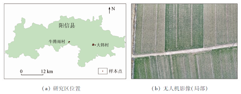
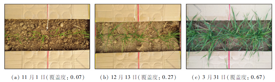
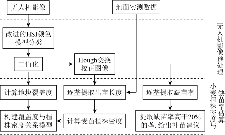
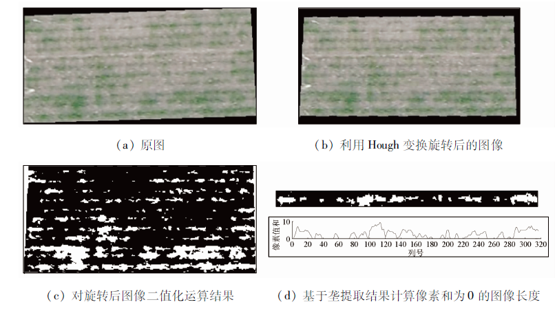
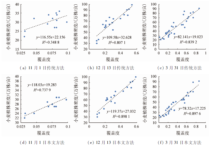
Abstract Wheat is a densely planted crop, and the planting volume per acre is nearly 20 kg. The plant density of winter wheat will directly affect the final yield. Therefore, real-time monitoring of wheat plant density is an important way to ensure wheat yield. At present, the main method for obtaining the plant density of wheat is mainly manual measurement, which is time-consuming and laborious. In this paper, the DJ inspire 2 UAV is equipped with a Zens X4S camera to obtain high-resolution visible light images of wheat planting areas, extract wheat coverage based on UAV images, and establish the relationship between plant density and plant density so as to achieve rapid acquisition of wheat plant density based on UAV image. Experiments show the following results: ① Using the improved HSI color model to extract wheat coverage improves accuracy and extraction efficiency compared with traditional visual estimation, manual counting and other classification methods, and overcomes differences in lighting conditions and shadows of different sorts of UAV images influences. ② There is a high correlation between wheat coverage and plant density at the seedling stage, overwintering stage and turning green stage. Among them, the correlation coefficient R2 between the coverage based on drone image and the plant density of wheat are 0.737 9, 0.898 1 and 0.897 6 in three growth stages. The verification results of the relationship model using Niutengyu Village samples show that the inversion results based on the established relationship model also have a good correlation with the measured values, and R2 reaches 0.919 8.
|
| Keywords
wheat
UAV image
vegetation cover
planting density
HSI color model
Hough transform
|
|
|
|
Corresponding Authors:
SU Wei
E-mail: wangwei007@cau.edu.cn;suwei@cau.edu.cn
|
|
Issue Date: 23 December 2020
|
|
|
| [1] |
周景博, 刘亮. 未来气候变化对中国小麦产量影响的差异性研究——基于Meta回归分析的定量综述[J]. 中国农业气象, 2018,39(3):141-151.
|
| [1] |
Zhou J B, Liu L. Study on the differences of the impact of future climate change on wheat yield in China quantitative review based on Meta regression analysis[J]. Chinese Journal of Agrometeorology, 2018,39(3):141-151.
|
| [2] |
石亚萍, 蔡静平. 种子发芽率快速测定方法的研究进展[J]. 粮油加工, 2008,23(5):89-91.
|
| [2] |
Shi Y P, Cai J P. Advances in the rapid determination of seed germination rate[J]. Grain and Oil Processing, 2008,23(5):89-91.
|
| [3] |
黄冬福. 种植密度影响水稻农艺性状的研究进展[J]. 安徽农学通报, 2012,18(1):70-71.
|
| [3] |
Huang D F. Research progress of planting density affecting rice agronomic traits[J]. Auhui Agricultural Science Bulletin, 2012,18(1):70-71.
|
| [4] |
Jin X, Li Z, Yang G, et al. Winter wheat yield estimation based on multi-source medium resolution optical and Radar imaging data and the Aqua Crop model using the particle swarm optimization algorithm[J]. ISPRS Journal of Photogrammetry and Remote Sensing, 2017,126:24-37.
|
| [5] |
赵舒怡, 宫兆宁, 刘旭颖. 2001—2013年华北地区植被覆盖度与干旱条件的相关分析[J]. 地理学报, 2015(5):31-43.
|
| [5] |
Zhao S Y, Gong Z N, Liu X Y. Correlation analysis between vegetation coverage and climate drought conditions in North China during 2001—2013[J]. Acta Geographica Sinica, 2015(5):31-43.
|
| [6] |
邢著荣, 冯幼贵, 杨贵军, 等. 基于遥感的植被覆盖度估算方法述评[J]. 遥感技术与应用, 2009,24(6):849-854.
|
| [6] |
Xing Z R, Feng Y G, Yang G J, et al. Method of estimating vegetation coverage based on remote sensing[J]. Remote Sensing Technology and Application, 2009,24(6):849-854.
|
| [7] |
Yang G J, Liu J G, Zhao C J, et al. Unmanned aerial vehicle remote sensing for field-based crop phenotyping:Current status and perspectives[J]. Frontiers in Plant Science, 2017,8:1111.
doi: 10.3389/fpls.2017.01111
pmid: 28713402
url: https://www.ncbi.nlm.nih.gov/pubmed/28713402
|
| [8] |
孙刚, 黄文江, 陈鹏飞, 等. 轻小型无人机多光谱遥感技术应用进展[J]. 农业机械学报, 2018,49(3):1-17.
|
| [8] |
Sun G, Huang W J, Chen P F, et al. Advances in UAV-based multispectral remote sensing applications[J]. Transactions of the Chinese Society for Agricultural Machinery, 2018,49(3):1-17.
|
| [9] |
刘建刚, 赵春江, 杨贵军, 等. 无人机遥感解析田间作物表型信息研究进展[J]. 农业工程学报, 2016,32(24):98-106.
url: http://www.tcsae.org/nygcxb/ch/reader/view_abstract.aspx?file_no=20162413&flag=1
|
| [9] |
Liu J G, Zhao C J, Yang G J, et al. Review of field-based phenotyping by unmanned aerial vehicle remote sensing platform[J]. Transactions of the Chinese Society of Agricultural Engineering, 2016,32(24):98-106.
|
| [10] |
王柯, 付怡然, 彭向阳, 等. 无人机低空遥感技术进展及典型行业应用综述[J]. 测绘通报, 2017(s1):79-83.
|
| [10] |
Wang K, Fu Y R, Peng X Y, et al. Overview of UAV low altitude remote sensing technology and application in typical industries[J]. Bulletin of Surveying and Mapping, 2017(s1):79-83.
|
| [11] |
Primicerio J, Gennaro S F D, Fiorillo E, et al. A flexible unmanned aerial vehicle for precision agriculture[J]. Precision Agriculture, 2012,13(4):517-523.
|
| [12] |
Sugiura R, Tsuda S, Tamiya S, et al. Field phenotyping system for the assessment of potato late blight resistance using RGB imagery from an unmanned aerial vehicle[J]. Biosystems Engineering, 2016,148:1-10.
|
| [13] |
刘峰, 刘素红, 向阳. 园地植被覆盖度的无人机遥感监测研究[J]. 农业机械学报, 2014,45(11):250-257.
|
| [13] |
Liu F, Liu S H, Xiang Y. Study on monitoring fractional vegetation cover of garden plots by unmanned aerial vehicles[J]. Transactions of the Chinese Society for Agricultural Machinery, 2014,45(11):250-257.
|
| [14] |
冯海英, 冯仲科, 冯海霞. 一种基于无人机高光谱数据的植被盖度估算新方法[J]. 光谱学与光谱分析, 2017,37(11):3573-3578.
|
| [14] |
Feng H Y, Feng Z K, Feng H X. A new method for estimating the fractional vegetation cover based on UVA hyperspectrum[J]. Spectroscopy and Spectral Analysis, 2017,37(11):3573-3578.
|
| [15] |
周在明, 杨燕明, 陈本清. 基于无人机遥感监测滩涂湿地入侵种互花米草植被覆盖度[J]. 应用生态学报, 2016,27(12):3920-3926.
pmid: 29704351
|
| [15] |
Zhou Z M, Yang Y M, Chen B Q. Fractional vegetation cover of invasive spartina alterniflora in coastal wetland using unmanned aerial vehicle (UAV) remote sensing[J]. Journal of Applied Ecology, 2016,27(12):3920-3926.
doi: 10.13287/j.1001-9332.201612.006
pmid: 29704351
url: https://www.ncbi.nlm.nih.gov/pubmed/29704351
|
| [16] |
郭震冬, 顾正东, 许盛, 等. 利用无人机技术进行社区植被覆盖率调查[J]. 北京测绘, 2017(5):88-91.
|
| [16] |
Guo Z D, Gu Z D, Xu S, et al. UAV-based investigation of community vegetation coverage[J]. Beijing Surveying and Mapping, 2017(5):88-91.
|
| [17] |
Chen J, Yi S, Yu Q, et al. Improving estimates of fractional vegetation cover based on UAV in alpine grassland on the Qinghai-Tibetan Plateau[J]. International Journal of Remote Sensing, 2016,37(8):1922-1936.
|
| [18] |
葛静, 孟宝平, 杨淑霞, 等. 基于UAV技术和MODIS遥感数据的高寒草地盖度动态变化监测研究——以黄河源东部地区为例[J]. 草业学报, 2017,26(3):1-12.
|
| [18] |
Ge J, Meng B P, Yang S X, et al. Dynamic monitoring of alpine grassland coverage based on UAV technology and MODIS remote sensing data:A case study in the headwaters of the Yellow River[J]. Acta Prataculturae Sinica, 2017,26(3):1-12.
|
| [19] |
李冰, 刘镕源, 刘素红, 等. 基于低空无人机遥感的冬小麦覆盖度变化监测[J]. 农业工程学报, 2012,28(13):160-165.
|
| [19] |
Li B, Liu R Y, Liu S H, et al. Monitoring vegetation coverage variation of winter wheat by low-altitude UAV remote sensing system[J]. Transactions of the Chinese Society of Agricultural Engineering, 2012,28(13):160-165.
|
| [20] |
牛亚晓, 张立元, 韩文霆, 等. 基于无人机遥感与植被指数的冬小麦覆盖度提取方法[J]. 农业机械学报, 2018,49(4):212-221.
|
| [20] |
Niu Y X, Zhang L Y, Han W T, et al. Fractional vegetation cover extraction method of winter wheat based on UAV remote sensing and vegetation index[J]. Transactions of the Chinese Society for Agricultural Machinery, 2018,49(4):212-221.
|
| [21] |
宋瑞霞, 孙相东, 王小春. 基于HSI颜色空间和暗原色先验的去雾算法[J]. 系统科学与数学, 2017,37(10):2111-2120.
|
| [21] |
Song R X, Sun X D, Wang X C. Haze removal algorithm based on HSI color space and dark channel prior[J]. Journal of Systems Science and Mathematical Sciences, 2017,37(10):2111-2120.
|
| [22] |
茅正冲, 孙雅慧. 基于HSI空间的玉米雄穗识别算法[J]. 传感器与微系统, 2018,37(9):117-119.
|
| [22] |
Mao Z C, Sun Y H. Algorithm of male tassel recognition based on HSI space[J]. Transducer and Microsystem Technologies, 2018,37(9):117-119.
|
| [23] |
Montalvo M, Pajares G, Guerrero J M, et al. Automatic detection of crop rows in maize fields with high weeds pressure[J]. Expert Systems with Applications, 2012,39(15):11889-11897.
|
| [24] |
Slaughter D C, Giles D K, Downey D. Autonomous robotic weed control systems:A review[J]. Computers and Electronics in Agriculture, 2008,61(1):63-78.
|
| [25] |
Liu T, Li R, Jin X L, et al. Evaluation of seed emergence uniformity of mechanically sown wheat with UAV RGB imagery[J]. Remote Sensing, 2017,9(12):1-15.
|
|
Viewed |
|
|
|
Full text
|
|
|
|
|
Abstract
|
|
|
|
|
Cited |
|
|
|
|
| |
Shared |
|
|
|
|
| |
Discussed |
|
|
|
|
 2020,
Vol. 32
2020,
Vol. 32