|
|
|
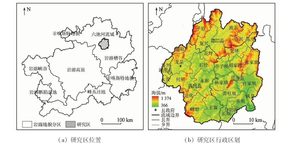
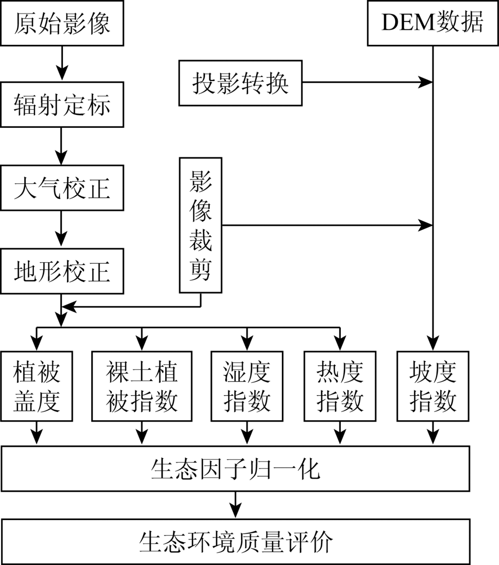
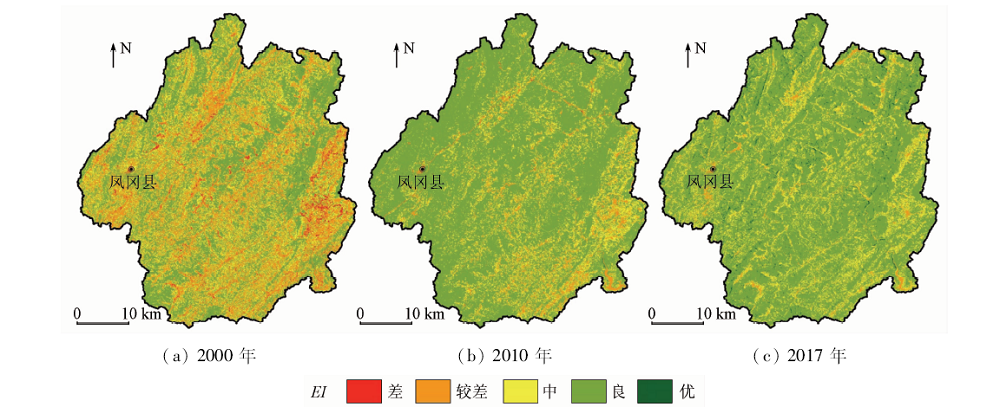
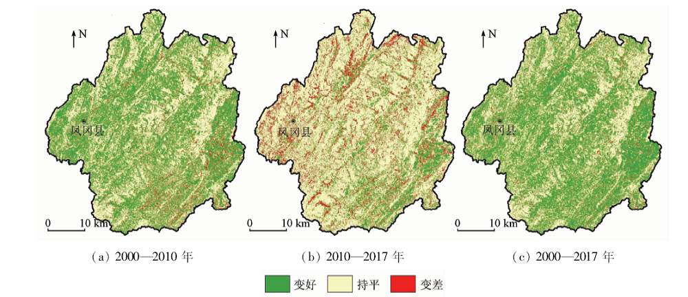
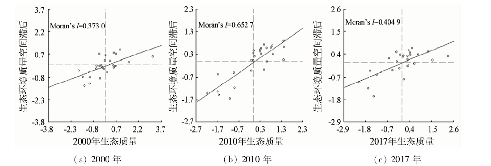
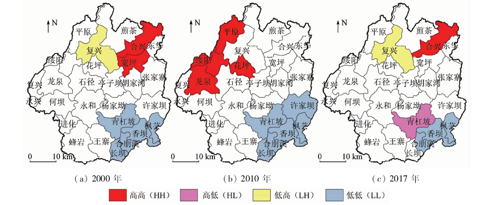
Abstract The ecological environment changes are related to social development. This paper analyzes the dynamic changes of the ecological environment quality of the Liuchi River Basin in Guizhou, in the hope of providing some reference that can promote the ecological civilization construction and environmental restoration of the watershed in the karst trough. The authors used remote sensing images which were from June to August, 2000, 2010 and 2017 Landsat satellites and GDEMDEM (30 m) data to extract vegetation cover, soil index, slope index, humidity and temperature index which served as the basis for constructing an ecological environment assessment model. In addition, spatial auto-correlation method was adopted to reveal the ecological environment that had different spatial and temporal characteristics in township scale. Some conclusions have been reached: ① From 2000 to 2017, the ecological environment quality showed a rapid restoration trend in the Liuchi River basin, but it varied differently in different counties. ② The quality of ecological environment showed significant differences in different towns. Meanwhile, the ecological improvement was slower in the county town and downstream towns, and was improved obviously in some towns of the central and southern area. ③ The ecological environment quality of towns had significant positive spatial agglomeration characteristics, and were dominated by high-high and low-low concentration in most years. In the trend analysis of towns’ ecological environment quality, the southeast basin was always the low-value zone, and the high-value zone is mainly distributed in the northern townships.
|
| Keywords
ecological environment quality
remote sensing assessment
spatial auto-correlation
karst trough
basin
|
|
|
|
Corresponding Authors:
LI Xudong
E-mail: gzyingkui@126.com;616507732@qq.com
|
|
Issue Date: 09 October 2020
|
|
|
| [1] |
徐燕, 周华荣. 初论我国生态环境质量评价研究进展[J]. 干旱区地理, 2003,26(2):166-172.
|
| [1] |
Xu Y, Zhou H R. A preliminary study on advances in assessment of eco-environmental quality in China[J]. Arid Land Geography, 2003,26(2):166-172.
|
| [2] |
苏维词, 李久林. 乌江流域生态环境预警评价初探[J]. 贵州科学, 1997,15(3):207-214.
|
| [2] |
Su W C, Li J L. A preliminary study on the warning appraisal of eco-environment in the Wujiang valley[J]. Guizhou Science, 1997,15(3):207-214.
|
| [3] |
王根绪, 钱鞠, 程国栋. 区域生态环境评价(REA)的方法与应用——以黑河流域为例[J]. 兰州大学学报, 2001,37(2):131-140.
|
| [3] |
Wang G X, Qian J, Cheng G D. The method of regions eco-environmental assessment and its usage in the case of Heihe River basin[J]. Journal of Lanzhou University, 2001,37(2):131-140.
|
| [4] |
李如忠. 基于灰关联理论的流域生态环境评价[J]. 合肥工业大学学报(自然科学版), 2002,25(3):464-467.
|
| [4] |
Li R Z. Eco-environmental assessment of basins based on grey associative theory[J]. Journal of Hefei University of Technology(Natural Science), 2002,25(3):464-467.
|
| [5] |
万新南, 刘家铎, 蔡劲松. 岷江上游“生态环境地质”质量评价体系[J]. 地球科学进展, 2004,19(s1):477-481.
|
| [5] |
Wan X N, Liu J D, Cai J S. Quality estimating system about bio-environmental geology at Minjiang River upstream[J]. Advance in Earth Sciences, 2004,19(s1):477-481.
|
| [6] |
姚文锋, 张思聪, 吕贤弼, 等. 海河流域生态环境质量评价[C]// 2004北京城市水利建设与发展国际学术研讨会——人与水·自然和谐发展——论文集.北京:[s.n.], 2004: 92-106.
|
| [6] |
Yao W F, Zhang S C, Lyu X B, et al. Evaluation of ecological environment quality in Haihe River basin[C]//Anthology of 2004 Beijing Urban Water Conservancy Construction and Development International Symposium Proceedings.Beijing:[s.n.], 2004: 92-106.
|
| [7] |
金菊良, 程吉林, 魏一鸣. 流域生态环境质量评价的熵模糊模式识别模型[J]. 四川大学学报(工程科学版), 2006,38(1):5-9.
|
| [7] |
Jin J L, Cheng J L, Wei Y M. Information entropy based fuzzy pattern recognition model for basin eco-environmental quality evaluation[J]. Journal of Sichuan University(Engineering Science Edition), 2006,38(1):5-9.
|
| [8] |
董思宜, 杨熙, 王秀兰, 等. 永定河流域生态环境质量评价[J]. 中国人口·资源与环境, 2013,23(s2):348-351.
|
| [8] |
Dong S Y, Yang X, Wang X L, et al. Assessment of the eco-environmental quality in the Yongding River basin[J]. China Population,Resources and Environment, 2013,23(s2):348-351.
|
| [9] |
王思梦, 黄昌. 基于遥感和GIS的流域自然生态环境质量监测与评价——以无定河流域为例[J]. 干旱区地理, 2018,41(1):134-141.
|
| [9] |
Wang S M, Huang C. Ecological environment quality monitoring and evaluation based on remote sensing and GIS techniques:A case of Wuding River basin[J]. Arid Land Geography, 2018,41(1):134-141.
|
| [10] |
魏伟, 石培基, 周俊菊, 等. 基于GIS和组合赋权法的石羊河流域生态环境质量评价[J]. 干旱区资源与环境, 2015,29(1):175-180.
|
| [10] |
Wei W, Shi P J, Zhou J J, et al. Comprehensive assessment of eco-environmental quality based on GIS and combination weighting method in Shiyang River basin[J]. Journal of Arid Land Resources and Environment, 2015,29(1):175-180.
|
| [11] |
周雪欣, 罗昊. 基于GIS与RS技术的北盘江流域生态环境质量评价研究[J]. 环境科学与管理, 2018,43(7):178-182.
|
| [11] |
Zhou X X, Luo H. Ecological environment quality assessment of Beipanjiang basin based on GIS and remote sense[J]. Environmental Science and Management, 2018,43(7):178-182.
|
| [12] |
芦颖, 李旭东, 杨正业. 1990—2015年贵州省乌江流域生态环境质量变化评价[J]. 水土保持通报, 2018,38(2):140-147.
|
| [12] |
Lu Y, Li X D, Yang Z Y. Evaluation on eco-environmental quality change of Wujiang River basin in Guizhou Province from 1990 to 2015[J]. Bulletin of Soil and Water Conservation, 2018,38(2):140-147.
|
| [13] |
安芬, 李旭东, 程东亚. 贵州省乌江流域生态脆弱性评价及其空间变化特征[J]. 水土保持通报, 2019,39(4):261-269.
|
| [13] |
An F, Li X D, Cheng D Y. Ecological vulnerability assessment and spatial variation characteristics of Wujiang River basin in Guizhou Province[J]. Bulletin of Soil and Water Conservation, 2019,39(4):261-269.
|
| [14] |
郑景云, 尹云鹤, 李炳元. 中国气候区划新方案[J]. 地理学报, 2010,65(1):3-12.
doi: 10.11821/xb201001002
url: http://www.geog.com.cn/CN/abstract/abstract21553.shtml
|
| [14] |
Zheng J Y, Yin Y H, Li B Y. A new scheme for climate regionalization in China[J]. Acta Geographica Sinica, 2010,65(1):3-12.
doi: 10.11821/xb201001002
url: http://www.geog.com.cn/CN/abstract/abstract21553.shtml
|
| [15] |
黄峰, 魏浪, 李磊, 等. 乌江干流中上游水电梯级开发水温累积效应[J]. 长江流域资源与环境, 2009,18(4):337-342.
url: http://yangtzebasin.whlib.ac.cn//CN/abstract/abstract9324.shtml
|
| [15] |
Huang F, Wei L, Li L, et al. Cumulative effects of water temperature by cascade hydropower stations built on upper and middle reaches of the Wujiang River[J]. Resources and Environment in the Yangtze Basin, 2009,18(4):337-342.
url: http://yangtzebasin.whlib.ac.cn//CN/abstract/abstract9324.shtml
|
| [16] |
谢人栋, 赵翠薇. 基于栅格尺度的喀斯特槽谷区生态环境脆弱性时空分异研究[J]. 长江科学院院报, 2018,35(4):48-53.
|
| [16] |
Xie R D, Zhao C W. Spatio-temporal differentiation of ecological environment vulnerability in karst trough region based on grid scale[J]. Journal of Yangtze River Scientific Research Institute, 2018,35(4):48-53.
|
| [17] |
熊康宁, 池永宽. 中国南方喀斯特生态系统面临的问题及对策[J]. 生态经济, 2015,31(1):23-30.
|
| [17] |
Xiong K N, Chi Y K. The problems in southern China karst ecosystem in southern of China and its countermeasures[J]. Ecological Economy, 2015,31(1):23-30.
doi: 10.1016/S0921-8009(99)00052-X
url: https://linkinghub.elsevier.com/retrieve/pii/S092180099900052X
|
| [18] |
国家统计局农村社会经济调查司. 中国县域统计年鉴(乡镇卷)—2018[M]. 北京: 中国统计出版社, 2018.
|
| [18] |
Department of Rural Social Economic Investigation, National Bureau of Statistics. China county statistical yearbook (township volume)—2018[M]. Beijing: China Statistics Press, 2018.
|
| [19] |
张继, 周旭, 蒋啸, 等. 贵州高原不同地貌区和植被类型水分利用效率的时空分异特征[J]. 山地学报, 2019,37(2):173-185.
|
| [19] |
Zhang J, Zhou X, Jiang X, et al. Spatial and temporal variability characteristics of water use efficiency in different landform regions and vegetation types of Guizhou plateau,China[J]. Mountain Research, 2019,37(2):173-185.
|
| [20] |
Tong X W, Wang K L, Yue Y M, et al. Quantifying the effectiveness of ecological restoration projects on long-term vegetation dynamics in the karst regions of Southwest China[J]. International Journal of Applied Earth Observation & Geoinformation, 2017,54:105-113.
doi: 10.1016/j.jag.2016.09.013
url: https://linkinghub.elsevier.com/retrieve/pii/S0303243416301702
|
| [21] |
吴志杰, 何国金, 黄绍霖, 等. 南方丘陵区植被覆盖度遥感估算的地形效应评估[J]. 遥感学报, 2017,21(1):159-167.
|
| [21] |
Wu Z J, He G J, Huang S L, et al. Terrain effects assessment on remotely sensed fractional vegetation cover in hilly area of southern China[J]. Journal of Remote Sensing, 2017,21(1):159-167.
|
| [22] |
田庆久, 闵祥军. 植被指数研究进展[J]. 地球科学进展, 1998,13(4):10-16.
|
| [22] |
Tian Q J, Min X J. Advances in study on vegetation indices[J]. Advances in Earth Science, 1998,13(4):10-16.
|
| [23] |
杨存建, 刘纪远, 张增祥, 等. GIS支持下不同坡度的土壤侵蚀特征分析[J]. 水土保持学报, 2002,16(6):46-49.
|
| [23] |
Yang C J, Liu J Y, Zhang Z X, et al. Analysis of features of soil erosion under different slope based on GIS[J]. Journal of Soil Water Conservation, 2002,16(6):46-49.
|
| [24] |
Crist E P. A TM tasseled cap equivalent transformation for reflectance factor data[J]. Remote Sensing of Environment, 1985,17(3):301-306.
doi: 10.1016/0034-4257(85)90102-6
url: https://linkinghub.elsevier.com/retrieve/pii/0034425785901026
|
| [25] |
Baig M H A, Zhang L F, Shuai T, et al. Derivation of a tasseled cap transformation based on Landsat8 at-satellite reflectance[J]. Remote Sensing Letters, 2014,5(5):423-431.
doi: 10.1080/2150704X.2014.915434
url: http://dx.doi.org/10.1080/2150704X.2014.915434
|
| [26] |
金点点, 宫兆宁. 基于Landsat系列数据地表温度反演算法对比分析——以齐齐哈尔市辖区为例[J]. 遥感技术与应用, 2018,33(5):830-841.
|
| [26] |
Jin D D, Gong Z N. Algorithms comparison of land surface temperature retrieval from Landsat series data:A case study in Qiqihar,China[J]. Remote Sensing Technology and Application, 2018,33(5):830-841.
|
| [27] |
任国平, 刘黎明, 管青春, 等. 基于生活质量的大都市郊区乡村性评价及空间自相关类型划分[J]. 农业工程学报, 2019,35(7):264-275,317.
url: http://www.tcsae.org/nygcxb/ch/reader/view_abstract.aspx?file_no=20190733&flag=1
|
| [27] |
Ren G P, Liu L M, Guan Q C, et al. Rurality evaluation and spatial autocorrelation type classification based on quality of life in metropolitan suburbs[J]. Transactions of the Chinese Society of Agricultural Engineering, 2019,35(7):264-275,317.
url: http://www.tcsae.org/nygcxb/ch/reader/view_abstract.aspx?file_no=20190733&flag=1
|
| [28] |
王莉红, 张军民, 陈文皓, 等. 玛纳斯河流域生态环境质量时空分异评价[J]. 干旱区研究, 2019,36(4):1015-1023.
|
| [28] |
Wang L H, Zhang J M, Chen W H, et al. Spatiotemporal differentiation of ecological environment quality in the Manas River basin[J]. Arid Zone Research, 2019,36(4):1015-1023.
|
| [29] |
王权, 李阳兵, 刘亚香. 岩溶槽谷区山坡-槽坝土地利用变化的对比研究[J]. 长江流域资源与环境, 2019,28(1):122-133.
|
| [29] |
Wang Q, Li Y B, Liu Y X. Comparative study of land use change in karst hillside-trough dam area[J]. Resources and Environment in the Yangtze Basin, 2019,28(1):122-133.
|
| [30] |
刘凌. 思南七里塘水电站大坝施工导流设计[J].科技创新导报, 2011(25):115.
|
| [30] |
Liu L. Diversion design of the dam construction of Sinan Qilitang Hydropower Station[J].Science and Technology Innovation Herald 2011(25):115.
|
| [31] |
张剑. 浅议贵州建设生态文明城市的目标与途径[C]//贵州省生态文明建设学术研讨会论文集.贵阳:[s.n.], 2008: 14-20.
|
| [31] |
Zhang J. Discussion on the objectives and ways of constructing ecological civilized city in Guizhou[C]//Anthology of Proceedings of Guizhou Province Ecological Civilization Construction Symposium.Guiyang:[s.n.], 2008: 14-20.
|
| [32] |
林琳. 实施贵州工业强省战略的思考[J].宏观经济管理, 2012(8):74-75.
|
| [32] |
Lin L. Thoughts on implementing the strategy of Guizhou’s industrial province[J].Macroeconomic Management 2012(8):74-75.
|
| [33] |
李阳兵, 黄娟, 徐倩, 等. 对石漠化概念及其治理的再思考[J]. 贵州师范大学学报(自然科学版), 2017,35(5):1-6,55.
|
| [33] |
Li Y B, Huang J, Xu Q, et al. Rethinking the concept and restoration of karst rocky desertification[J]. Journal of Guizhou Normal University(Natural Sciences), 2017,35(5):1-6,55.
|
| [34] |
贵州省林业局. 贵州省第三次石漠化监测成果公报[R]. 贵阳:贵州林业局, 2018.
|
| [34] |
Guizhou Forestry Bureau. Bulletin on the third rock desertification monitoring results in Guizhou Province[R]. Guiyang:Guizhou Forestry Bureau, 2018.
|
| [35] |
程东亚, 李旭东. 西南山地流域林地和草地保护评价研究——以贵州赤水河流域为例[J]. 水土保持研究, 2019,26(4):328-335.
|
| [35] |
Cheng D Y, Li X D. Research on evaluation of forestland and grassland protection in southwest mountainous basin:A case study of the Chishui River basin in Guizhou Province[J]. Research of Soil and Water Conservation, 2019,26(4):328-335.
|
|
Viewed |
|
|
|
Full text
|
|
|
|
|
Abstract
|
|
|
|
|
Cited |
|
|
|
|
| |
Shared |
|
|
|
|
| |
Discussed |
|
|
|
|
 2020,
Vol. 32
2020,
Vol. 32
 ), LI Xudong(