|
|
 |
|

|
|
|
Assessment of Karst rocky desertification based on MODIS: Exemplified by Guizhou Province |
Linlin WU1,2, Yunlan GUAN1,2( ), Jiawei LI3, Chenxin YUAN1, Rui LI1 ), Jiawei LI3, Chenxin YUAN1, Rui LI1 |
1. Faculty of Geomatics, East China University of Technology, Nanchang 330013, China
2. Key Laboratory of Watershed Ecology and Geographical Environment Monitoring, National Administration of Surveying,Mapping and Geoinformation, Nanchang 330013, China
3. South Digital Technology Co., Ltd., Guangzhou 510665, China |
|
|
|
|
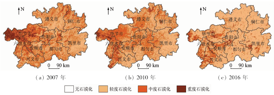
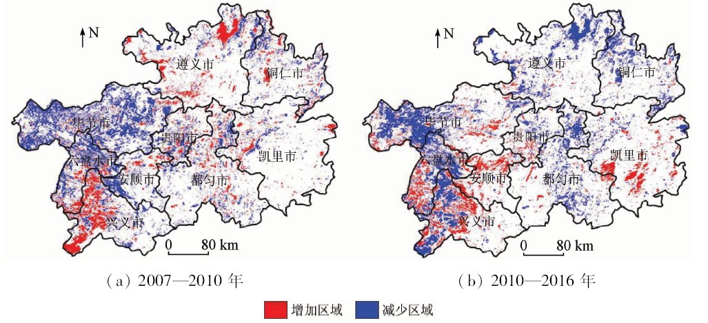
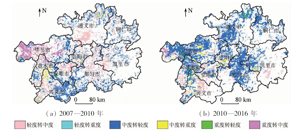
Abstract Monitoring the spatial pattern and dynamic change of Karst rocky desertification has an important significance in Karst areas. In this study, the Karst rocky desertification evaluation model was established in Guizhou Province, which based on vegetation fractional coverage and degree of exposed bedrock using multi-temporal MODIS data, slope and population density as evaluation factors. The contribution of four factors was compared to accomplish the judgment matrix and calculate the weight by analytic hierarchy process. Karst rocky desertification evaluation model was established through consistency check. By this evaluation model, the spatial patterns of Karst rocky desertification and characteristics of conversion in different degree of desertification were acquired, the spatial-temporal evolution and dynamic change of Karst rocky desertification were analyzed in the period of 2007—2016. Some conclusions have been reached: ①Karst rocky desertification was improved dramatically from 2007 to 2016. The proportion of moderate rocky desertification and severe rocky desertification was 55.67% and 40.53% respectively in 2010 but was 79.71% and 17.35% in 2016. ②Moderate rocky desertification was the intermediary process of severe rocky desertification transform to light rocky desertification. It can firstly transform severe rocky desertification to moderate rocky desertification and then transform to light rocky desertification. ③Moderate rocky desertification and light rocky desertification were active, whereas severe rocky desertification was stable and the conversion rate was low.
|
| Keywords
Karst rocky desertification
evaluation model of rocky desertification
rocky desertification of Guizhou Province
MODIS
|
|
|
|
Corresponding Authors:
Yunlan GUAN
E-mail: guan8098@163.com
|
|
Issue Date: 03 December 2019
|
|
|
| [1] |
高贵龙, 邓自民, 熊康宁 , 等. 喀斯特的呼唤与希望——贵州喀斯特生态环境建设与可持续发展[M]. 贵阳: 贵州科技出版社, 2003.
|
| [1] |
Gao G L, Deng Z M, Xiong K N , et al. The Call and Hope of Karst:Construction and Sustainable Development of Karst Ecological Environment in Guizhou Province[M]. Guiyang: Guizhou Science and Technology Publishing House Co.,Ltd., 2003.
|
| [2] |
袁春, 周常萍, 童立强 , 等. 贵州土地石漠化的形成原因及其治理对策[J]. 现代地质, 2003,17(2):181-185.
|
| [2] |
Yuan C, Zhou C P, Tong L Q , et al. The causes and tackle countermeasures of land rocky desertification in Guizhou Province[J]. Geo-science, 2003,17(2):181-185.
|
| [3] |
王世杰 . 喀斯特石漠化概念演绎及其科学内涵的探讨[J]. 中国岩溶, 2002,21(2):101-105.
|
| [3] |
Wang S J . Concept deduction and its connotation of Karst rocky desertification[J]. Carsologica Sinica, 2002,21(2):101-105.
|
| [4] |
李水明, 舒宁, 陶建斌 , 等. 一种基于K2结构学习算法的石漠化数据特征选择方法[J]. 桂林理工大学学报, 2009,29(4):548-554.
|
| [4] |
Li S M, Shu N, Tao J B , et al. Rock desertification data feature selection method based on K2 structure learning algorithm[J]. Journal of Guilin University of Technology, 2009,29(4):548-554.
|
| [5] |
蓝安军, 熊康宁, 安裕伦 . 喀斯特石漠化的驱动因子分析——以贵州省为例[J]. 水土保持通报, 2001,21(6):19-23.
|
| [5] |
Lan A J, Xiong K N, An Y L . Analysis on driving factors of Karst rock-desertification with a special reference to Guizhou Province[J]. Bulletin of Soil and Water Conservation, 2001,21(6):19-23.
|
| [6] |
李松, 安裕伦, 华厚强 . 基于遥感变化检测的石漠化信息自动提取[J]. 遥感技术与应用, 2012,27(1):149-153.
|
| [6] |
Li S, An Y L, Hua H Q . Automated method based on change detection for extracting Karst rock desertification information using remote sensing[J]. Remote Sensing Technology and Application, 2012,27(1):149-153.
|
| [7] |
王昆 . 典型喀斯特地区石漠化演变关键因子阈值研究与预警分析[D]. 贵阳:贵州师范大学, 2016.
|
| [7] |
Wang K . Research on the Threshold of the Key Factors for the Evolution of Rocky Desertification in Typical Karst Area and Early Warning Analysis[D]. Guiyang:Guizhou Normal University, 2016.
|
| [8] |
刘京伟, 王华书 . 贵州喀斯特地区生态环境建设与农村经济发展研究[J]. 贵州农业科学, 2010,38(6):227-231.
|
| [8] |
Liu J W, Wang H S . Ecological environmental construction and rural economic development in Karst mountainous areas of Guizhou Province[J]. Guizhou Agriculture Sciences, 2010,38(6):227-231.
|
| [9] |
白晓永, 王世杰, 陈起伟 , 等. 贵州土地石漠化类型时空演变过程及其评价[J]. 地理学报, 2009,64(5):609-618.
doi: 10.11821/xb200905010
url: http://d.wanfangdata.com.cn/Periodical/dlxb200905010
|
| [9] |
Bai X Y, Wang S J, Chen Q W , et al. Spatio-temporal evolution process and its evaluation method of Karst rocky desertification in Guizhou Province[J]. Acta Geographica Sinca, 2009,64(5):609-618.
|
| [10] |
李阳兵, 王世杰, 李瑞玲 , 等. 关于西南岩溶山区生态建设的一些讨论——以贵州省为例[J]. 中国岩溶, 2004,23(1):20-24.
|
| [10] |
Li Y B, Wang S J, Li R L , et al. Discussion on the construction to Karst mountain ecology in southwest China:A case in Guizhou Province[J]. Carsologica Sinca, 2004,23(1):20-24.
|
| [11] |
胡锋 . 亚喀斯特地区景观特征与生态环境效应探讨研究——以贵州为例[D]. 贵阳:贵州师范大学, 2016.
|
| [11] |
Hu F . Study on the Landscape Features and Ecological Environment Effect of Semi-Karst Region:A Case Study of Guizhou Province[D]. Guiyang:Guizhou Normal University, 2016.
|
| [12] |
李瑞玲, 王世杰, 熊康宁 , 等. 喀斯特石漠化评价指标体系探讨——以贵州省为例[J]. 热带地理, 2004,24(2):145-149.
doi: 10.3969/j.issn.1001-5221.2004.02.011
url: http://d.wanfangdata.com.cn/Periodical/rddl200402011
|
| [12] |
Li R L, Wang S J, Xiong K N , et al. A study on rocky desertification index system:A case of Guizhou Province[J]. Tropical Geography, 2004,24(2):145-149.
|
| [13] |
黄岩, 谢世友, 赵亚萍 . 基于ETM影像的喀斯特石漠化调查研究——以重庆南川市为例[J]. 国土资源遥感, 2008,20(1):55-58.doi: 10.6046/gtzyyg.2008.01.12.
doi: 10.6046/gtzyyg.2008.01.12
|
| [13] |
Huang Y, Xie S Y, Zhao Y P . Karst desertification investigation based on ETM image:A case study of Nanchuan City[J]. Remote Sensing for Land and Resourses, 2008,20(1):55-58.doi: 10.6046/gtzyyg.2008.01.12.
|
| [14] |
马志勇, 沈涛, 张军海 , 等. 基于植被覆盖度的植被变化分析[J].测绘通报,2007(3):45-48.
|
| [14] |
Ma Z Y, Shen T, Zhang J H , et al. Vegetation changes analysis based on vegetation coverage[J].Bulletin of Surveying and Mapping,2007(3):45-48.
|
| [15] |
党宇宁, 南亲江, 吴虹 . 坡度因子对喀斯特石漠化的影响[J]. 地质学刊, 2016,40(4):674-677.
|
| [15] |
Dang Y N, Nan Q J, Wu H . Effects of slope factors on Karst rocky desertification[J]. Journal of Geology, 2016,40(4):674-677.
|
| [16] |
张佳华, 张国平, 王培娟 . 植被与生态遥感[M]. 北京: 科学出版社, 2010.
|
| [16] |
Zhang J H, Zhang G P, Wang P J. Vegetation and Ecological Remote Sensing[M]. Beijing: Science Press, 2010.
|
| [17] |
岳跃民, 王克林, 张兵 , 等. 喀斯特石漠化信息遥感提取的不确定性[J]. 地球科学进展, 2011,26(3):266-274.
|
| [17] |
Yue Y M, Wang K L, Zhang B , et al. Uncertainty of remotely sensing extraction of information of Karst rocky desertification[J]. Advances in Earth Science, 2011,26(3):266-274.
|
| [18] |
李苗苗 . 植被覆盖度的遥感估算方法研究[D].北京:中国科学院研究生院( 遥感应用研究所), 2003.
|
| [18] |
Li M M . The Method of Vegetation Fraction Estimating by Remote Sensing[D].Beijing:Chinese academy of science( IRSA), 2003.
|
| [19] |
岳跃民, 张兵, 王克林 , 等. 石漠化遥感评价因子提取研究[J]. 遥感学报, 2011,15(4):722-736.
doi: 10.11834/jrs.20110124
|
| [19] |
Yue Y M, Zhang B, Wang K L , et al. Remote sensing of indicators for evaluating Karst rocky desertification[J]. Journal of Remote Sensing, 2011,15(4):722-736.
|
| [20] |
Rikimaru A. Landsat TM data processing guide for forest canopy density mapping and monitoring model [C]//ITTO workshop on utilization of remote sensing in site assessment and planning for rehabilitation of logged-over forest,Bangkok,Thailand, 1996,8:1-8.
|
| [21] |
Saaty T L . The Analytic Hierarchy Process:Planning,Priority Setting,Resource Allocation[M]. New York:Mc Graw-Hill, 1980.
|
| [22] |
刘芳, 何报寅, 张亮 , 等. 基于热红外遥感的广西平果县石漠化初步研究[J]. 长江流域资源与环境, 2016,25(6):952-956.
doi: 10.11870/cjlyzyyhj201606011
|
| [22] |
Liu F, He B Y, Zhang L , et al. Evaluation of Karst rocky desertification based on thermal infrared remote sensing in Pingguo Country,Guangxi[J]. Resources and Environment in the Yangtze Basin, 2016,25(6):952-956.
|
| [23] |
李丽, 童立强, 李小慧 . 基于植被覆盖度的石漠化遥感信息提取方法研究[J]. 国土资源遥感, 2010,22(2):59-62.doi: 10.6046/gtzyyg.2010.02.13.
doi: 10.6046/gtzyyg.2010.02.13
|
| [23] |
Li L, Tong L Q, Li X H . The remote sensing information extraction method based on vegetation coverage[J]. Remote Sensing for Land and Resources, 2010,22(2):59-62.doi: 10.6046/gtzyyg.2010.02.13.
|
| [24] |
鞠建华, 宋宏儒, 周萍 . 我国西南地区石漠化现状遥感调查[ C]//全国国土资源与环境遥感技术应用交流会, 2004.
|
| [24] |
Ju J H, Song H R, Zhou P . Karst rocky desertification current survey in Southwest China[ C]//National Land Resource and Environmental Remote Sensing Technology Conference, 2004.
|
| [25] |
赵丽苹 . 基于MODIS数据的喀斯特地区石漠化时空演变特征研究[D].北京:中国地质大学( 北京), 2015.
|
| [25] |
Zhao L P . Study on Developmental Characteristics of the Karst Rocky Desertification Based on MODIS[D].Beijing:China University of Geosciences( Beijing), 2015.
|
| [26] |
熊康宁, 黎平, 周忠发 , 等. 喀斯特石漠化的遥感-GIS典型研究[M]. 北京: 地质出版社, 2002.
|
| [26] |
Xiong K N, Li P, Zhou Z F , et al. Karst Rocky Desertification Remote Sensing-GIS Typical Research[M]. Beijing: Geological Publishing House, 2002.
|
| [27] |
李霞, 徐涵秋, 李晶 , 等. 基于NDSI和NDISI指数的SPOT-5影像裸土信息提取[J].地球信息科学学报,2016(1):117-123.
|
| [27] |
Li X, Xu H Q, Li J , et al. Extraction of bare soil features from SPOT-5 imagery based on NDSI and NDISI[J].Journal of Geo-Information Science,2016(1):117-123.
|
|
Viewed |
|
|
|
Full text
|
|
|
|
|
Abstract
|
|
|
|
|
Cited |
|
|
|
|
| |
Shared |
|
|
|
|
| |
Discussed |
|
|
|
|
 2019,
Vol. 31
2019,
Vol. 31