|
|
|
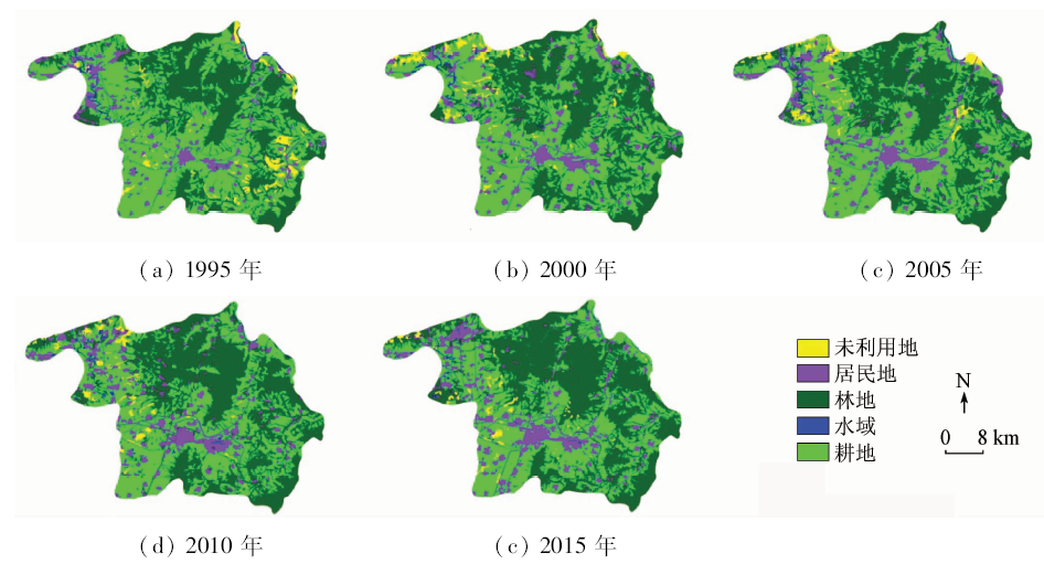
Abstract In this study, the authors used TM remote sensing images in 1995, 2000, 2005, 2010 and OLI remote sensing image in 2015 as data sources, classified the image by decision tree method based on CART (classification and regression tree)to obtain the land use information of Lucheng City of Shanxi Province and did accuracy assessment. Then the dynamic change of land use was analyzed by such means as the extent of land use change, the single land use dynamics, and the integrated index of land use change degree. In addition, the GM(1, 1) model was built using first four data and was verified by the actual data in 2015 . At last, the land use of Lucheng City in 2020 was predicted by using the GM (1,1) model. According to the results obtained, the forest area and the residential area increased, the agriculture area and the unused land area decreased, and the water area remained about the same in the 20 years from 1995 to 2015 in Lucheng City; the development degree achieved the medium level and the land use structure remained about the same. In 2020, the predicted value of agriculture area in Lucheng City will be 22 759.32 hm 2 and the predicted value of residential area will be 8 854.76 hm 2.
|
| Keywords
TM
OLI
CART
land use dynamic change
GM(1,1)
|
|
|
|
Corresponding Authors:
Qiaozhen GUO
E-mail: sangxiao1993@126.com;gqiaozhen@tcu.edu.cn
|
|
Issue Date: 30 May 2018
|
|
|
| [1] |
何美香 . 县域土地利用动态变化研究——以山西省怀仁县为例[D]. 长沙:中南大学, 2010.
|
| [1] |
He M X . Study on Dynamic Change of County-Level Land Use:A Case Study of Huairen Country in Shanxi Province[D]. Changsha:Central South University, 2010.
|
| [2] |
Durieux L, Lagabrielle E, Nelson A . A method for monitoring building construction in urban sprawl areas using object-based analysis of SPOT5 images and existing GIS data[J]. ISPRS Journal of Photogrammetry and Remote Sensing, 2008,63(4):339-408.
doi: 10.1016/j.isprsjprs.2008.01.005
url: http://www.sciencedirect.com/science/article/pii/S0924271608000154
|
| [3] |
Sylla L, Xiong D, Zhang H Y , et al. A GIS technology and method to assess environmental problems from land use/cover changes: Conakry,Coyah and Dubreka region case study[J]. The Egyptian Journal of Remote Sensing and Space Science, 2012,15(1):31-38.
doi: 10.1016/j.ejrs.2011.12.002
url: http://linkinghub.elsevier.com/retrieve/pii/S1110982311000378
|
| [4] |
Zhang Y J, Li A J, Fung T . Using GIS and multi-criteria decision analysis for conflict resolution in land use planning[J]. Procedia Environmental Sciences, 2012,13:2264-2273.
doi: 10.1016/j.proenv.2012.01.215
url: http://linkinghub.elsevier.com/retrieve/pii/S1878029612002162
|
| [5] |
Martine N . GIS and multi-criteria decision analysis for land use resource planning[J]. Journal of Geographic Information System, 2012,4(4):341-348.
doi: 10.4236/jgis.2012.44039
url: http://www.scirp.org/journal/doi.aspx?DOI=10.4236/jgis.2012.44039
|
| [6] |
朱晓强, 李满春, 金晓斌 , 等. 土地利用规划在城市郊区历史遗迹保护中的应用——以无锡市新区为例[J].北京第二外国语学院学报, 2006(5):43-46,22.
|
| [6] |
Zhu X Q, Li M C, Jin X B , et al. Application of land use planning in historic sites protection in urban fringe: Example the studies of the new district of Wuxi[J].Journal Beijing International Studies University, 2006(5):43-46,22.
|
| [7] |
吴健生, 谢舞丹, 李嘉诚 . 土地利用回归模型在大气污染时空分异研究中的应用[J]. 环境科学, 2016,37(2):413-419.
doi: 10.13227/j.hjkx.2016.02.002
url: http://d.wanfangdata.com.cn/Periodical/hjkx201602003
|
| [7] |
Wu J S, Xie W D, Li J C . Application of land-use regression models in spatial-temporal differentiation of air pollution[J]. Environmental Science, 2016,37(2):413-419.
|
| [8] |
李炟, 束炯, 谈建国 , 等. 基于土地利用和人为热修正的城市夏季高温数值试验[J]. 热带气象学报, 2015,31(3):364-373.
doi: 10.16032/j.issn.1004-4965.2015.03.008
url: http://www.cqvip.com/QK/92292X/201503/665423879.html
|
| [8] |
Li D, Shu J, Tan J G , et al. A numerical simulation experiment of an urban summer heat wave based on modified data of land-use and anthropogenic heat[J]. Journal of Tropical Meteorology, 2015,31(3):364-373.
|
| [9] |
史泽鹏, 马中文, 马友华 , 等. 基于J48决策树算法的遥感土地利用变化分析[J]. 遥感信息, 2014,29(1):78-84.
doi: 10.3969/j.issn.1000-3177.2014.01.016
url: http://www.cqvip.com/QK/92871X/201401/1003261397.html
|
| [9] |
Shi Z P, Ma Z W, Ma Y H , et al. Land use change of remote sensing based on J48 decision tree algorithm[J]. Remote Sensing Information, 2014,29(1):78-84.
|
| [10] |
丁月平 . 辅以纹理特征的面向对象遥感影像土地分类研究——以南通市港闸区为例[D]. 南京:南京林业大学, 2014.
|
| [10] |
Ding Y P . Research on Land Classification of Object Oriented Remote Sensing Image Based on Texture Features :A Case Study of Gangzha District of Nantong City[D]. Nanjing:Nanjing Forestry University, 2014.
|
| [11] |
江华 . 基于eCognition面向对象技术的高分辨率遥感影像土地利用分类——以福州琅岐岛为例[J].海峡科学, 2014(8):12-17.
|
| [11] |
Jiang H . High resolution remote sensing image classification of land use based on eCognition object-oriented technology:Setting Langqi Island of Fuzhou as an example[J].Straits Science, 2014(8):12-17.
|
| [12] |
领梅, 安慧君, 贺晓辉 , 等. 基于决策树的凉城县土地利用分类研究[J]. 内蒙古农业大学学报, 2013,34(6):43-48.
url: http://www.cqvip.com/QK/92455X/201306/49190403.html
|
| [12] |
Ling M, An H J, He X H , et al. Research of land use classification based on decision tree in Liangcheng[J]. Journal of Inner Mongolia Agricultural University, 2013,34(6):43-48.
|
| [13] |
吴健生, 潘况一, 彭建 , 等. 基于QUEST决策树的遥感影像土地利用分类——以云南省丽江市为例[J]. 地理研究, 2012,31(11):1973-1980.
doi: 10.11821/yj2012110005
url: http://www.cqvip.com/QK/95732X/201211/43880177.html
|
| [13] |
Wu J S, Pan K Y, Peng J , et al. Research on the accuracy of TM images land-use classification based on QUEST decision tree:A case study of Lijiang in Yunnan[J]. Geographical Research, 2012,31(11):1973-1980.
|
| [14] |
肖艳, 姜琦刚, 王斌 , 等. 基于Relief F和PSO混合特征选择的面向对象土地利用分类[J]. 农业工程学报, 2016,32(4):211-216.
doi: 10.11975/j.issn.1002-6819.2016.04.030
url: http://d.wanfangdata.com.cn/Periodical/nygcxb201604030
|
| [14] |
Xiao Y, Jiang Q G, Wang B , et al. Object based land-use classification based on hybrid feature selection method of combining Relief F and PSO[J]. Transactions of the Chinese Society of Agricultural Engineering, 2016,32(4):211-216.
|
| [15] |
黄秀霞, 孙力 . C4.5算法的优化[J]. 计算机工程与设计, 2016,37(5):1265-1270,1361.
|
| [15] |
Huang X X, Sun L . Optimization of C4.5 algorithm[J]. Computer Engineering and Design, 2016,37(5):1265-1270,1361.
|
| [16] |
吴琳娜, 杨胜天, 刘晓燕 , 等. 1976 年以来北洛河流域土地利用变化对人类活动程度的响应[J]. 地理学报, 2014,69(1):54-63.
doi: 10.11821/dlxb201401005
url: http://d.wanfangdata.com.cn/Periodical/dlxb201401005
|
| [16] |
Wu L N, Yang S T, Liu X Y , et al.Response analysis of land use change to the degree of human activities in Beiluo River basin since 1976[J]. Acta Geographica Sinica, 2014,69(1):54-63.
|
| [17] |
宗玮 . 上海海岸带土地利用/覆盖格局变化及驱动机制研究[D]. 上海:华东师范大学, 2012.
|
| [17] |
Zong W . Research on Land Use/Land Cover Change and Driving Forces Mechanism in Coastal Zone of Shanghai[D]. Shanghai:East China Normal University, 2012.
|
|
Viewed |
|
|
|
Full text
|
|
|
|
|
Abstract
|
|
|
|
|
Cited |
|
|
|
|
| |
Shared |
|
|
|
|
| |
Discussed |
|
|
|
|
 2018,
Vol. 30
2018,
Vol. 30
 ), Qiaozhen GUO(