|
|
 |
|

|
|
|
Spatial-temporal characteristics of construction land expansion and occupation of cultivated land in urban agglomeration of central and southern Liaoning Province based on Remote Sensing |
REN Xiaoyan1,2( ), HE Yanfen1(), WANG Zongming2 ), HE Yanfen1(), WANG Zongming2 |
1. College of Urban and Environmental Sciences, Northwest University, Xi’an 710127, China
2. Key Laboratory of Wetland Ecology and Environment, Northeast Institute of Geography and Agroecology, Chinese Academy of Sciences, Changchun 130102, China |
|
|
|
|
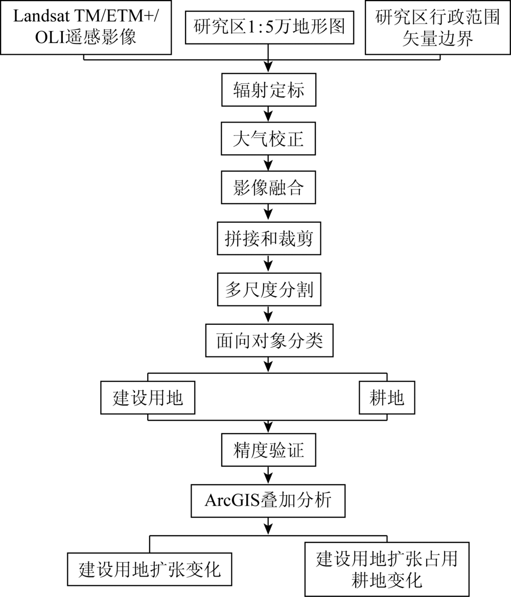
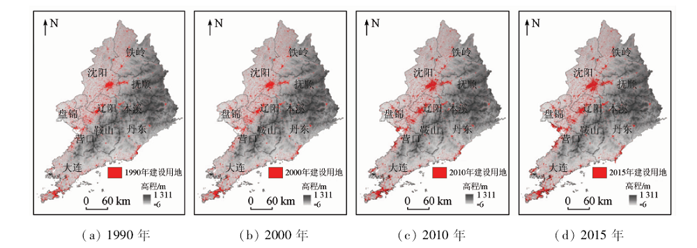
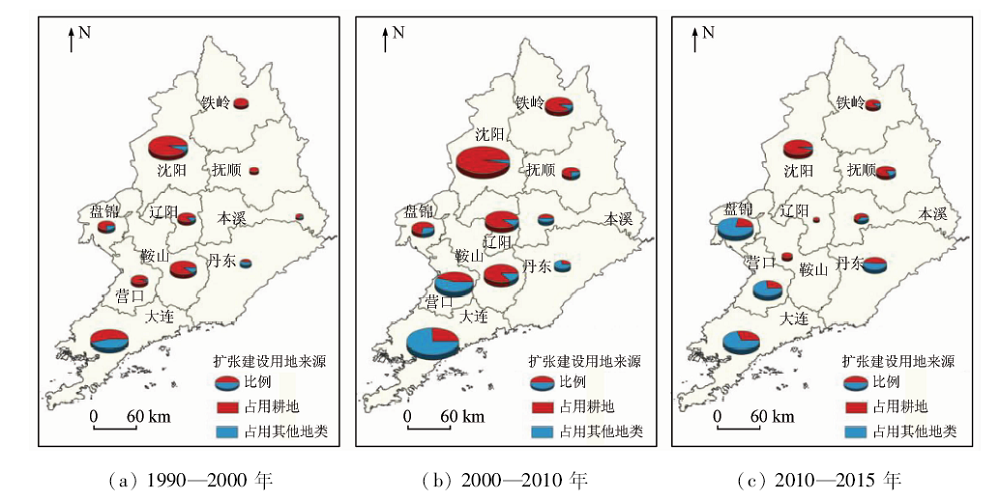
Abstract This study observed relatively developed urbanized and industrialized urban agglomeration in central and southern Liaoning. The authors used remote sensing data as the information source to study the expansion of construction land and the characteristics of its occupation of cultivated land. The results show that, from 1990 to 2015, the total land use for construction of urban agglomeration in central and southern Liaoning increased by 1 942.07 km 2, with an increasing rate of 30.52%, in which 64.68% of new construction land was derived from the occupation of cultivated land. The difference in the expansion of construction land among cities was obvious. The comparison of data in different periods shows that the expansion rate of construction land in central and southern Liaoning had a turning point. During the study period, the area of cultivated land in central and southern Liaoning continued to decrease, and 79.76% of its loss was converted into construction land. Due to the advancement of agricultural science and technology, the current reduction in cultivated land area has a small impact on grain production in central and southern Liaoning. However, some cities have caused food production reduction due to occupation of cultivated land, which requires further attention.
|
| Keywords
urban agglomeration of central and southern Liaoning
construction land expansion
occupied cultivated land
remote sensing
|
|
|
|
Corresponding Authors:
HE Yanfen
E-mail: renxy824@163.com;yanfen_lily@163.com
|
|
Issue Date: 09 October 2020
|
|
|
| [1] |
Sun Y, Zhao S Q, et al. Spatiotemporal dynamics of urban expansion in 13 cities across the Jing-Jin-Ji urban agglomeration from 1978 to 2015[J]. Ecological Indicators:Integrating,Monitoring,Assessment and Management, 2018,87:302-313.
|
| [2] |
谈明洪, 李秀彬, 吕昌河. 20世纪90年代中国大中城市建设用地扩张及其对耕地的占用[J].中国科学(地球科学), 2004(12):1157-1165.
|
| [2] |
Tan M H, Li X B, Lyu C H. A study on large and medium-sized cities construction land expansion and its occupation of cultivated land of China in the 1990s[J]. Science in China(Earth Sciences), 2004,34(12):1157-1165.
|
| [3] |
闫梅, 黄金川, 彭实铖. 中部地区建设用地扩张对耕地及粮食生产的影响[J]. 经济地理, 2011,31(7):1157-1164.
|
| [3] |
Yan M, Huang J C, Peng S C, et al. The influence of construction land expansion to cultivated land and grain production in Central China[J]. Economic Geography, 2011,31(7):1157-1164.
|
| [4] |
黄季焜, 朱莉芬, 邓祥征. 中国建设用地扩张的区域差异及其影响因素[J].中国科学(地球科学), 2007(9):1235-1241.
|
| [4] |
Huang J K, Zhu L F, Deng X Z. Regional differences of China’s construction land expansion and its influencing factors[J].Science in China(Earth Sciences) 2007(9):1235-1241.
|
| [5] |
史静静, 谈镇. 协调发展视角下共享经济与新型城镇化战略的多维互动[J]. 城市发展研究, 2018,25(2):118-124.
|
| [5] |
Shi J J, Tan Z. Multi-dimensional interaction between sharing economy and newtype urbanization strategy from the perspective of coordinated development[J]. Urban Development Studies, 2018,25(2):118-124.
|
| [6] |
李晓江, 尹强, 张娟, 等. 《中国城镇化道路、模式与政策》研究报告综述[J].城市规划学刊, 2014(2):1-14.
|
| [6] |
Li X J, Yin Q, Zhang J, et al. The path,mode,police of urbanization in China[J].Urban Planning Forum 2014(2):1-14.
|
| [7] |
丁成日. 美国土地开发权转让制度及其对中国耕地保护的启示[J].中国土地科学, 2008(3):74-80.
url: http://d.wanfangdata.com.cn/Periodical_zhonggtdkx200803011.aspx
|
| [7] |
Ding C R. The transferable development rights in the USA and its implications to cultivated land conservation in China[J].China Land Science 2008(3):74-80.
url: http://d.wanfangdata.com.cn/Periodical_zhonggtdkx200803011.aspx
|
| [8] |
吴业, 杨桂山, 万荣荣. 耕地变化与社会经济发展关系研究进展[J].地理科学进展, 2008(1):90-98.
doi: 10.11820/dlkxjz.2008.01.012
url: http://www.dlkxjz.com.cn/CN/abstract/abstract8728.shtml
|
| [8] |
Wu Y, Yang G S, Wan R R. Advances in researches on relations between cultivated land change and socio-economic development[J].Progress in Geography 2008(1):90-98.
doi: 10.11820/dlkxjz.2008.01.012
url: http://www.dlkxjz.com.cn/CN/abstract/abstract8728.shtml
|
| [9] |
中国人民大学宏观经济分析与预测课题组, 张杰. 进入创新和产业融合发展关键期的中国经济[J].经济理论与经济管理, 2017(12):5-22.
|
| [9] |
Research Group of Macroeconomic Analysis and Prediction Renmin University of China, Zhang J. Entering into the critical period of interation between innovation and industry development in China[J].Economic Theory and Business Management 2017(12):5-22.
|
| [10] |
刘涛, 史秋洁, 王雨, 等. 中国城乡建设占用耕地的时空格局及形成机制[J]. 地理研究, 2018,37(8):1609-1623.
|
| [10] |
Liu T, Shi Q J, Wang Y, et al. Urban-rural development and occupation of cultivated land in China:Trends,geography,and drivers[J]. Geographical Research, 2018,37(8):1609-1623.
|
| [11] |
傅泽强, 蔡运龙, 杨友孝, 等. 中国粮食安全与耕地资源变化的相关分析[J].自然资源学报, 2001(4):313-319.
|
| [11] |
Fu Z Q, Cai Y L, Yang Y X, et al. Research on the relationship of cultivated land change and food security in China[J].Journal of Natural Resources 2001(4):313-319.
|
| [12] |
Liu T, Liu H, Qi Y J. Construction land expansion and cultivated land protection in urbanizing China:Insights from national land surveys,1996—2006[J]. Habitat International, 2015,46:13-22.
doi: 10.1016/j.habitatint.2014.10.019
url: https://linkinghub.elsevier.com/retrieve/pii/S019739751400157X
|
| [13] |
杨璐嘉, 李建强, 梅卫威, 等. 四川省建设占用耕地与经济发展的脱钩分析[J].国土与自然资源研究, 2011(4):29-31.
url: http://d.wanfangdata.com.cn/Periodical_gtyzrzyyj201104012.aspx
|
| [13] |
Yang L J, Li J Q, Mei W W, et al. Study on the decoupling between cultivated land occupation by construction and economic development in Sichuan Province[J].Territory & Natural Resources Study 2011(4):29-31.
|
| [14] |
孟祥凤, 王冬艳, 李红, 等. 典型黑土区建设占用耕地的时空配置效率研究[J]. 资源开发与市场, 2017,33(8):948-953,911.
|
| [14] |
Meng X F, Wang D Y, Li H, et al. Research on time-space allocation efficiency of cultivated land for construction purposes in typical black soil area[J]. Resource Development & Market, 2017,33(8):948-953,911.
|
| [15] |
樊杰, 盛科荣. 辽宁中部城市群发展的经济基础分析[J].城市规划, 2004(1):37-41.
url: http://d.wanfangdata.com.cn/Periodical_csgh200401009.aspx
|
| [15] |
Fan J, Sheng K R. Analysis on economic base of the city cluster in central Liaoning Province[J]. Urban planning, 2004,28(1):37-41.
|
| [16] |
樊杰, 刘汉初, 王亚飞, 等. 东北现象再解析和东北振兴预判研究——对影响国土空间开发保护格局变化稳定因素的初探[J]. 地理科学, 2016,36(10):1445-1456.
|
| [16] |
Fan J, Liu H C, Wang Y F, et al. “The Northeast China Phenomenon”and prejudgment on economic revitalization in northeast China:A primary research on stable factors to impact national spatial development and protection pattern[J]. Scientia Geographica Sinica, 2016,36(10):1445-1456.
|
| [17] |
李晓燕, 李慧颖, 满卫东, 等. 哈长城市群城镇用地扩展进程及其驱动因素研究[J]. 地理科学, 2018,38(8):1273-1282.
doi: 10.13249/j.cnki.sgs.2018.08.009
url: http://geoscien.neigae.ac.cn/CN/abstract/abstract40630.shtml
|
| [17] |
Li X Y, Li H Y, Man W D, et al. Process and driving factors of urban land expansion in Harbin-Changchun city cluster[J]. Scientia Geographica Sinica, 2018,38(8):1273-1282.
doi: 10.13249/j.cnki.sgs.2018.08.009
url: http://geoscien.neigae.ac.cn/CN/abstract/abstract40630.shtml
|
| [18] |
张翰超, 宁晓刚, 王浩, 等. 基于高分辨率遥感影像的2000—2015年中国省会城市高精度扩张监测与分析[J]. 地理学报, 2018,73(12):2345-2363.
doi: 10.11821/dlxb201812006
url: http://www.geog.com.cn/CN/abstract/abstract40804.shtml
|
| [18] |
Zhang H C, Ning X G, Wang H, et al. High accuracy urban expansion monitoring and analysis of China’s provincial capitals from 2000 to 2015 based on high-resolution remote sensing imagery[J]. Acta Geographica Sinica, 2018,73(12):2345-2363.
doi: 10.11821/dlxb201812006
url: http://www.geog.com.cn/CN/abstract/abstract40804.shtml
|
|
Viewed |
|
|
|
Full text
|
|
|
|
|
Abstract
|
|
|
|
|
Cited |
|
|
|
|
| |
Shared |
|
|
|
|
| |
Discussed |
|
|
|
|
 2020,
Vol. 32
2020,
Vol. 32