|
|
 |
|

|
|
|
Method research of intelligentized extraction of natural resources information from Shihe District,Xinyang City,Henan Province |
WANG Yuefeng1,2( ), WU Huizhi1,2, HE Shujun1,2, HUANG Di2,3, BAI Chaojun1,2 ), WU Huizhi1,2, HE Shujun1,2, HUANG Di2,3, BAI Chaojun1,2 |
1. Henan Institute of Geological Survey, Zhengzhou 450001, China
2. Geological Remote Sensing Centre of National Engineering Lab for Satellite Remote Sensing Applications, Zhengzhou 450001, China
3. Henan Institute of Geological Sciences, Zhengzhou 450001, China |
|
|
|
|
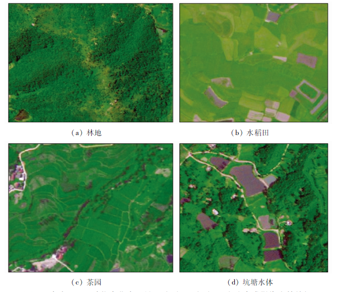
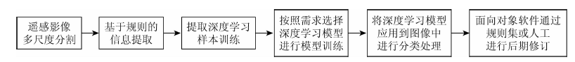
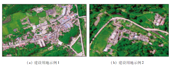
Abstract Based on “Easy Interpretation” image processing software and using BJ-2 satellite remote sensing images, the method of “object-oriented+deep learning” was introduced into the intelligent information extraction and automatic classification of the 200 km 2 test plot in Shihe District, Xinyang City, which included forestland, tea garden, paddy land, water area, construction land and some other land. By the method of ratio vegetation index (RVI) in combination with the real-time selection of the boundary index threshold and eigenvalues, the forestland, tea garden and paddy land information of the test plot was classified intelligently. The water area information was extracted intelligently by the green and near-infrared band normalized difference vegetation index (NDVI). The information of construction land was extracted by using standard deviation of band1 as the eigenvalues. Based on the above methods and field geological survey, the results show that the intelligent information extraction in the test plot has a high accuracy of over 90%. The efficiency is 19 times higher than the traditional method. The study shows that “Easy Interpretation” image processing software is effective and highly accurate and can do half the work with twice the results, which has good value for extension and application in the intelligentized interpretation of natural resources and environment.
|
| Keywords
Easy Interpretation
natural resources
intelligentized extraction
automatically classification
|
|
|
|
Issue Date: 23 December 2020
|
|
|
| [1] |
李晓彤, 覃先林, 刘树超, 等. 基于GF-1 WFV数据森林叶面积指数估算[J]. 国土资源遥感, 2019,31(3):80-86.doi: 10.6046/gtzyyg.2019.03.11.
|
| [1] |
Li X T, Qin X L, Liu S C, et al. Estimation of forest leaf area index based on GF-1 WFV data[J]. Remote Sensing for Land and Resources, 2019,31(3):80-86.doi: 10.6046/gtzyyg.2019.03.11.
|
| [2] |
童旭东. 中国高分辨率对地观测系统重大专项建设进展[J]. 遥感学报, 2016,20(5):775-780.
|
| [2] |
Tong X D. Development of China high-resolution earth observation system[J]. Journal of Remote Sensing, 2016,20(5):775-780.
|
| [3] |
李德仁, 童庆禧, 李荣兴, 等. 高分辨率对地观测的若干前沿科学问题[J]. 中国科学(地球科学), 2012,42(6):805-813.
|
| [3] |
Li D R, Tong Q X, Li R X, et al. Current issues in high-resolution Earth observation technology[J]. Scientia Sinica Terrae, 2012,42(6):805-813.
doi: 10.1360/zd-2012-42-6-805
url: http://engine.scichina.com/doi/10.1360/zd-2012-42-6-805
|
| [4] |
陈洁丽, 刘水学, 李满春, 等. 基于归一化指数分析的居民地遥感信息提取[J]. 测绘科学, 2010,35(2):204-206.
|
| [4] |
Chen J L, Liu S X, Li M C, et al. Extracting remote sensing information of residential areas based on the analysis of normalized difference index[J]. Science of Surveying and Mapping, 2010,35(2):204-206.
|
| [5] |
查勇, 倪绍祥, 杨山. 一种利用TM图像自动提取城镇用地信息的有效方法[J]. 遥感学报, 2003,7(1):37-40.
|
| [5] |
Zha Y, Ni S X, Yang S. An effective approach to automatically extract urban land-use from TM imagery[J]. Journal of Remote Sensing, 2003,7(1):37-40.
|
| [6] |
陈杰. 高分辨率遥感影像面向对象分类方法研究[D]. 长沙:中南大学, 2010.
|
| [6] |
Chen J. Study on object-based classification of high-resolution remote sensing imagery[D]. Changsha:Central South University, 2010.
|
| [7] |
宫鹏, 黎夏, 徐冰. 高分辨率影像解译理论与应用方法中的一些研究问题[J]. 遥感学报, 2006,10(1):1-5.
|
| [7] |
Gong P, Li X, Xu B. Interpretation theory and application method development for information extraction from high resolution remotely sensed data[J]. Journal of Remote Sensing, 2006,10(1):1-5.
|
| [8] |
明冬萍, 骆剑承, 沈占锋, 等. 高分辨率遥感影像信息提取与目标识别技术研究[J]. 测绘科学, 2005,30(3):18-20.
|
| [8] |
Ming D P, Luo J C, Shen Z F, et al. Research on information extraction and target recognition fromhigh resolution remote sensing image[J]. Science of Surveying and Mapping, 2005,30(3):18-20.
|
| [9] |
陶建伟. 最新光学高分辨率卫星遥感技术及其应用研究[D]. 上海:上海交通大学, 2011.
|
| [9] |
Tao J W. A study on state-of-art optical high resolution remote sensing satellite technology and its application[D]. Shanghai:Shanghai Jiao Tong University, 2011.
|
| [10] |
赵英时. 遥感应用分析原理与方法[M]. 北京: 科学出版社, 2003.
|
| [10] |
Zhao Y S. Principle and methods of remote sensing applications and analysis[M]. Beijing: Science Press, 2003.
|
| [11] |
陈忠. 高分辨率遥感图像分类技术研究[D]. 北京:中国科学院研究生院, 2006.
|
| [11] |
Chen Z. Research on high resolution remote sensing image classification technology[D]. Beijing:Chinese Academy of Sciences, 2006.
|
| [12] |
明冬萍, 高分辨率遥感特征基元提取与格局判别方法研究[D]. 北京:中国科学院研究生院, 2006.
|
| [12] |
Ming D P. Study of parcel unit extraction based-on features and pattern distinguishment from high spatial resolution remote sensing images[D]. Beijing:Chinese Academy of Sciences, 2006.
|
| [13] |
明冬萍, 骆剑承, 周成虎, 等. 高分辨率遥感影像特征分割及算法评价分析[J]. 地球信息科学, 2006,8(1):103-109.
|
| [13] |
Ming D P, Luo J C, Zhou C H, et al. Research on high resolution remote sensing image segmentation methods based on features and evaluation of algorithms[J]. Geo-Information Science, 2006,8(1):103-109.
url: http://www.dqxxkx.cn/CN/abstract/abstract9007.shtml
|
| [14] |
吴俐民, 左小青, 倪曙, 等. 卫星遥感影像专题信息提取技术与应用[M]. 成都: 西南交通大学出版社, 2013.
|
| [14] |
Wu L M, Zuo X Q, Ni S, et al. Technology and applications of thematic information extraction from satellite remote sensing images[M]. Chengdu: Southwest Jiaotong University Press, 2013.
|
|
Viewed |
|
|
|
Full text
|
|
|
|
|
Abstract
|
|
|
|
|
Cited |
|
|
|
|
| |
Shared |
|
|
|
|
| |
Discussed |
|
|
|
|
 2020,
Vol. 32
2020,
Vol. 32