|
|
|
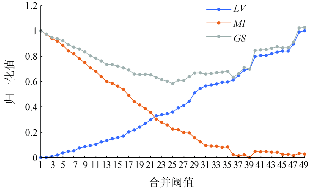
Abstract The extraction of mosaic lines is an important step in the mosaic of remote sensing images. To address the problems related to mosaic line extraction existing in current mosaic techniques of high-resolution remote sensing images, the authors propose a mosaic line extraction method based on multi-scale segmentation and the A* algorithm and the steps are as follows. First, pre-segment the overlapping regions of images using the simple linear iterative cluster (SLIC) algorithm, and conduct the clustering of regions with notable surface features to generate compact superpixels to obtain and extract the texture information of the surface features in the images. Then, merge the adjacent regions by continuously increasing the regional dissimilarity threshold while recording the region merging process using a scale set model. Meanwhile, determine the optimal segmentation scale according to the local variance of spectral characteristics and the Moran index to solve the problem of over-segmentation. Finally, find out the best mosaic lines on the segmentation paths using the A* algorithm. Experimental results prove that this method can effectively solve the problem that mosaic lines pass through distinct areas such as buildings, farmlands, and rivers, thus reducing splicing traces. Meanwhile, the optimal segmentation scale can be effectively selected by recording the merging process using a scale set model. Therefore, the mosaic line extraction method proposed in this study can be widely applied in the mosaic of high-resolution remote sensing images and is practically significant for the automatic mosaic of remote sensing images.
|
| Keywords
orthoimage
multi-scale segmentation
extraction of mosaic line
A* algorithm
|
|
|
|
Corresponding Authors:
WANG Shutao
E-mail: ytwen@ysu.cn;wangshutao@ysu.edu.cn
|
|
Issue Date: 23 December 2021
|
|
|
| [1] |
徐冠华, 柳钦火, 陈良富, 等. 遥感与中国可持续发展:机遇和挑战[J]. 遥感学报, 2016,20(5):679-688.
|
| [1] |
Xu G H, Liu Q H, Chen L F, et al. Remote sensing for China’s sustainable development:Opportunities and challenges[J]. Journal of Remote Sensing, 2016,20(5):679-688.
|
| [2] |
薛白. 多源遥感卫星影像镶嵌技术方法研究[D]. 北京:中国地质大学(北京), 2019.
|
| [2] |
Xue B. Study on the mosaic technique of multi-source remote sensing satellite images[D]. Beijing:China University of Geosciences(Beijing), 2019.
|
| [3] |
桂新, 程朋根, 聂运菊, 等. 基于形态学与Dijkstra相结合的影像镶嵌线方法[J]. 测绘与空间地理信息, 2015,38(7):18-20.
|
| [3] |
Gui X, Cheng P G, Nie Y J, et al. Image mosaicking seamline approach based on the morphological and Dijkstra algorithm[J]. Geomatics & Spatial Information Technology, 2015,38(7):18-20.
|
| [4] |
周清华, 潘俊, 李德仁. 遥感图像镶嵌接缝线自动生成方法综述[J]. 国土资源遥感, 2013,25(2):1-7.doi: 10.6046/gtzyyg.2013.02.01.
doi: 10.6046/gtzyyg.2013.02.01
|
| [4] |
Zhou Q H, Pan J, Li D R. Overview of automatic generation of mosaicking seamlines for remote sensing images[J]. Remote Sensing for Land and Resources, 2013,25(2):1-7.doi: 10.6046/gtzyyg.2013.02.01.
doi: 10.6046/gtzyyg.2013.02.01
|
| [5] |
宫思伟, 陈时雨, 蔡杨. 最小化最大边权的正射影像镶嵌线自动搜索[J]. 测绘地理信息, 2020,45(4):104-109.
|
| [5] |
Gong S W, Chen S Y, Cai Y. Seamline detection for orthoimage mosaicking based on minimizing the maximum edge weight algorithm[J]. Journal of Geomatics, 2020,45(4):104-109.
|
| [6] |
左志权, 张祖勋, 张剑清, 等. DSM辅助下城区大比例尺正射影像镶嵌线智能检测[J]. 测绘学报, 2011,40(1):84-89.
|
| [6] |
Zuo Z Q, Zhang Z X, Zhang J Q, et al. Seamlines intelligent detection in large-scale urban orthoimage mosaicking[J]. Acta Geodaetica et Cartographica Sinica, 2011,40(1):84-89.
|
| [7] |
Pan J, Zhou Q, Wang M. Seamline determination based on segmentation for urban image mosaicking[J]. IEEE Geoscience & Remote Sensing Letters, 2014,11(8):1335-1339.
|
| [8] |
钟斌. 基于初始规划网的镶嵌线自动生成方法研究[J]. 测绘与空间地理信息, 2016,39(1):211-213.
|
| [8] |
Zhong B. Study on method of generating mosaic lines automatically based on the initial planning network[J]. Geomatics & Spatial Information Technology, 2016,39(1):211-213.
|
| [9] |
Wan Y C, Wang D L, Xiao J H, et al. Automatic determination of seamlines for aerial image mosaicking based on vector roads alone[J]. ISPRS Journal of Photogrammetry and Remote Sensing, 2013,76:1-10.
doi: 10.1016/j.isprsjprs.2012.11.002
url: https://linkinghub.elsevier.com/retrieve/pii/S092427161200202X
|
| [10] |
韩天庆. 结合SURF和分水岭分割的遥感影像镶嵌线提取[D]. 徐州:中国矿业大学, 2014.
|
| [10] |
Han T Q. Seamline extraction for remote sensing images by incorporating SURF and watershed segmentation[D]. Xuzhou:China University of Mining and Technology, 2014.
|
| [11] |
岳贵杰, 杜黎明, 刘凤德, 等. A*搜索算法的正射影像镶嵌线自动提取[J]. 测绘科学, 2015,40(4):151-154.
|
| [11] |
Yue G J, Du L M, Liu F D, et al. Automatic seamline detection for orthophoto mosaicking based on A* searching algorithm[J]. Science of Surveying and Mapping, 2015,40(4):151-154.
|
| [12] |
Bai X D, Cao Z G, Wang Y, et al. Image segmentation using modified SLIC and Nyström based spectral clustering[J]. OPTIK, 2014,125(16):4302-4307.
doi: 10.1016/j.ijleo.2014.03.035
url: https://linkinghub.elsevier.com/retrieve/pii/S0030402614004471
|
| [13] |
姚丙秀, 黄亮, 许艳松. 一种结合超像素和图论的高分辨率遥感影像分割方法[J]. 国土资源遥感, 2019,31(3):72-79.doi: 10.6046/gtzyyg.2019.03.10.
doi: 10.6046/gtzyyg.2019.03.10
|
| [13] |
Yao B X, Huang L, Xu Y S. A high resolution remote sensing image segmentation method based on superpixel and graph theory[J]. Remote Sensing for Land and Resources, 2019,31(3):72-79.doi: 10.6046/gtzyyg.2019.03.10.
doi: 10.6046/gtzyyg.2019.03.10
|
| [14] |
Wang Y, Qi Q, Shen X J. Image segmentation of brain MRI based on LTriDP and superpixels of improved SLIC[J]. Brain Sciences, 2020,10(2):116-130.
doi: 10.3390/brainsci10020116
url: https://www.mdpi.com/2076-3425/10/2/116
|
| [15] |
Achanta R, Shaji A, Smith K, et al. SLIC superpixels compared to state-of-the-art superpixel methods[J]. IEEE Trans actions on Pattern Analysis and Machine Intelligence, 2012,34(11):2274-2282.
|
| [16] |
Boemer F, Ratner E, Lendasse A. Parameter-Free image segmentation with SLIC[J]. Neurocomputing, 2018,277(1):228-236.
doi: 10.1016/j.neucom.2017.05.096
url: https://linkinghub.elsevier.com/retrieve/pii/S0925231217313978
|
| [17] |
刘云翔, 杜杰, 张晴. 基于路径优化的A*算法与Dijkstra算法的性能比较[J]. 现代电子技术, 2017,40(13):181-183,186.
|
| [17] |
Liu Y X, Du J, Zhang Q. Performance comparison between A* algorithm and Dijkstra algorithm based on path optimization[J]. Modern Electronics Technique, 2017,40(13):181-183,186.
|
| [18] |
Hu Z W, Zhang Q, Zou Q, et al. Stepwise evolution analysis of the region-merging segmentation for scale parameterization[J]. IEEE Journal of Selected Topics in Applied Earth Observations and Remote Sensing, 2018,11(7):2461-2472.
doi: 10.1109/JSTARS.4609443
url: https://ieeexplore.ieee.org/xpl/RecentIssue.jsp?punumber=4609443
|
| [19] |
Zheng M T, Xiong X D, Zhu J F. A novel orthoimage mosaic method using a weighted A* algorithm:Implementation and evaluation[J]. ISPRS Journal of Photogrammetry and Remote Sensing, 2018,138:30-46.
doi: 10.1016/j.isprsjprs.2018.02.007
url: https://linkinghub.elsevier.com/retrieve/pii/S0924271618300364
|
| [20] |
Vincent L, Soille P. Watersheds in digital spaces:An efficient algorithm based on immersion simulations[J]. IEEE Transactions on Pattern Analysis and Machine Intelligence, 1991,13(6):583-598.
doi: 10.1109/34.87344
url: http://ieeexplore.ieee.org/document/87344/
|
| [21] |
刘波, 张源, 程涛, 等. 基于高分二号卫星影像的城市不透水面提取[J]. 地理信息世界, 2017,24(2):103-107.
|
| [21] |
Liu B, Zhang Y, Cheng T, et al. Urban impervious surface extraction based on the GF-2 satellite imagery[J]. Geomatics World, 2017,24(2):103-107.
|
|
Viewed |
|
|
|
Full text
|
|
|
|
|
Abstract
|
|
|
|
|
Cited |
|
|
|
|
| |
Shared |
|
|
|
|
| |
Discussed |
|
|
|
|
 2021,
Vol. 33
2021,
Vol. 33
 ), WANG Tiezhu, WANG Shutao(