|
|
 |
|

|
|
|
GIS-based study on the deployment of video monitoring points for epidemic prevention in the Xishuangbanna border area |
LI Yimin1,2( ), YANG Yiming1, ZHAO Zhifang1,2,3(), WU Bowen1 ), YANG Yiming1, ZHAO Zhifang1,2,3(), WU Bowen1 |
1. College of Earth Science, Yunnan University, Kunming 650500, China
2. Yunnan University Research Center of Domestic High-Resolution Satellite Remote Sensing Geological Engineering, Kunming 650500, China
3. Key Laboratory of Sanjiang Metallogeny and Resources Exploration, Ministry of Natural Resources, Kunming 650500, China |
|
|
|
|
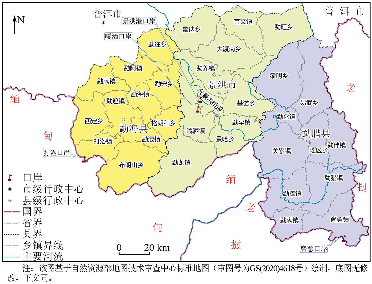
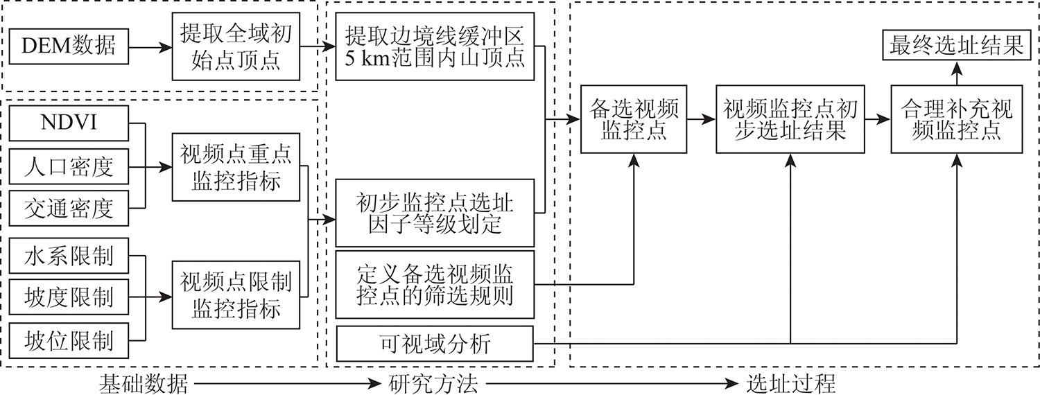
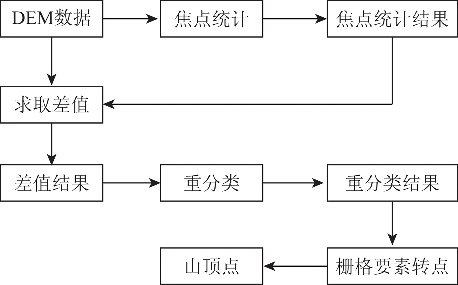
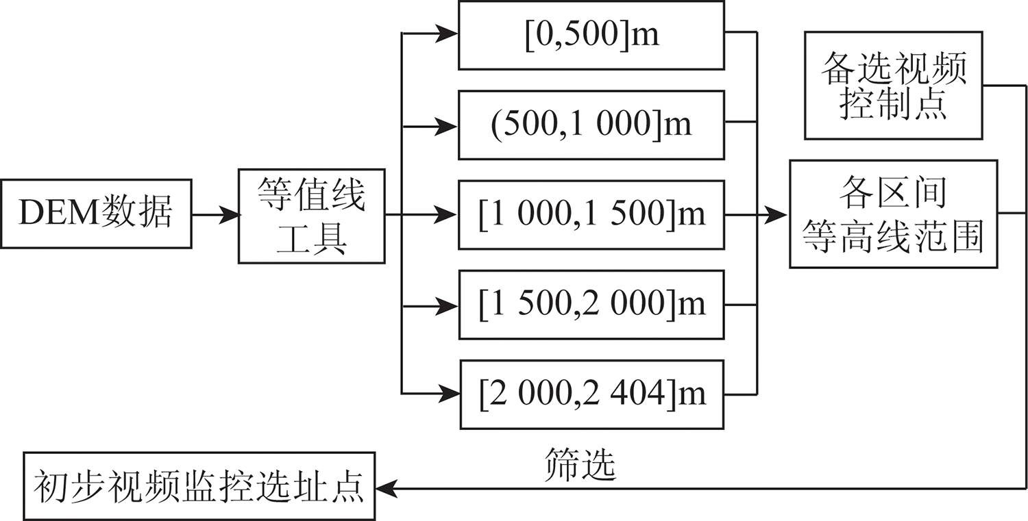
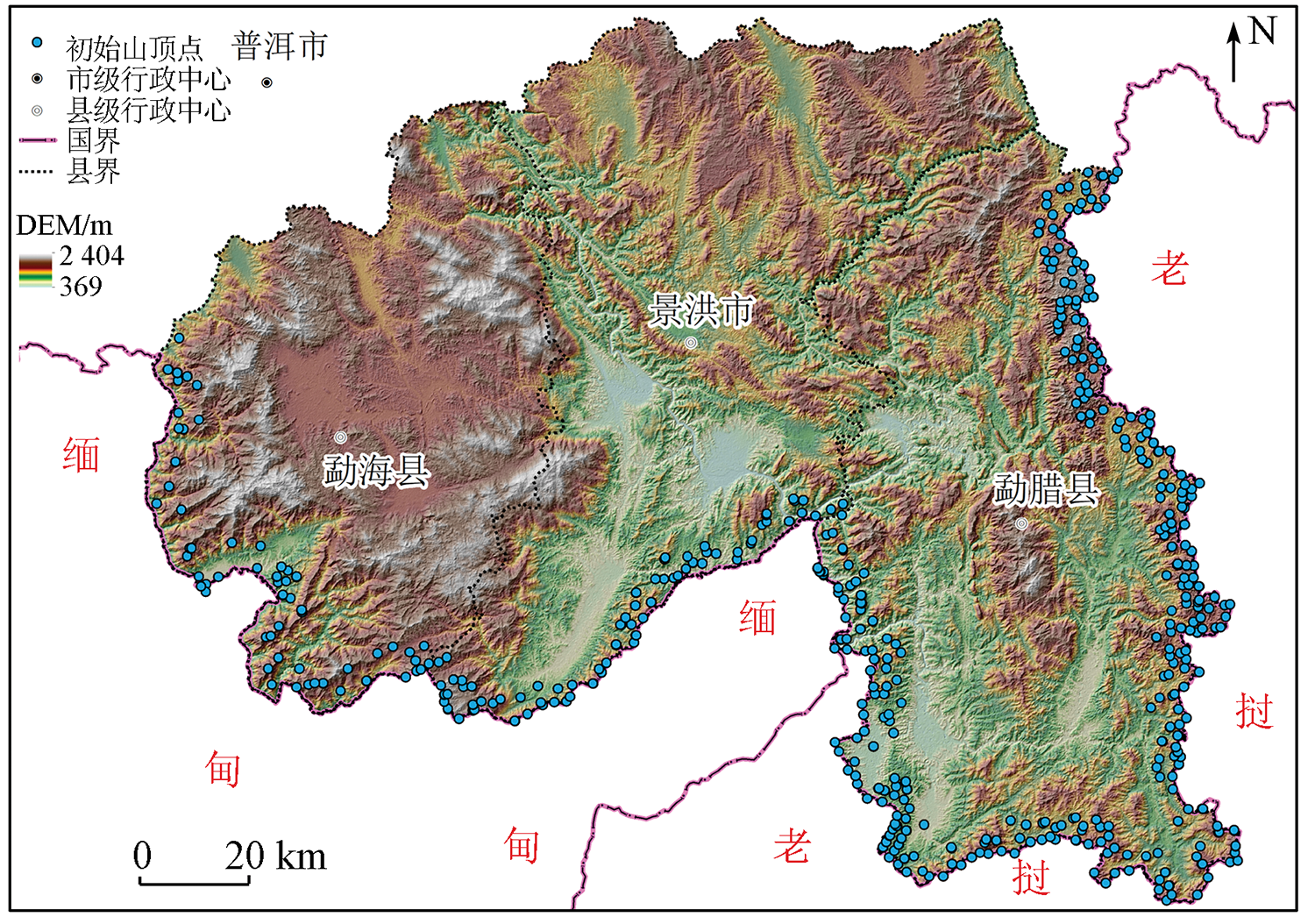
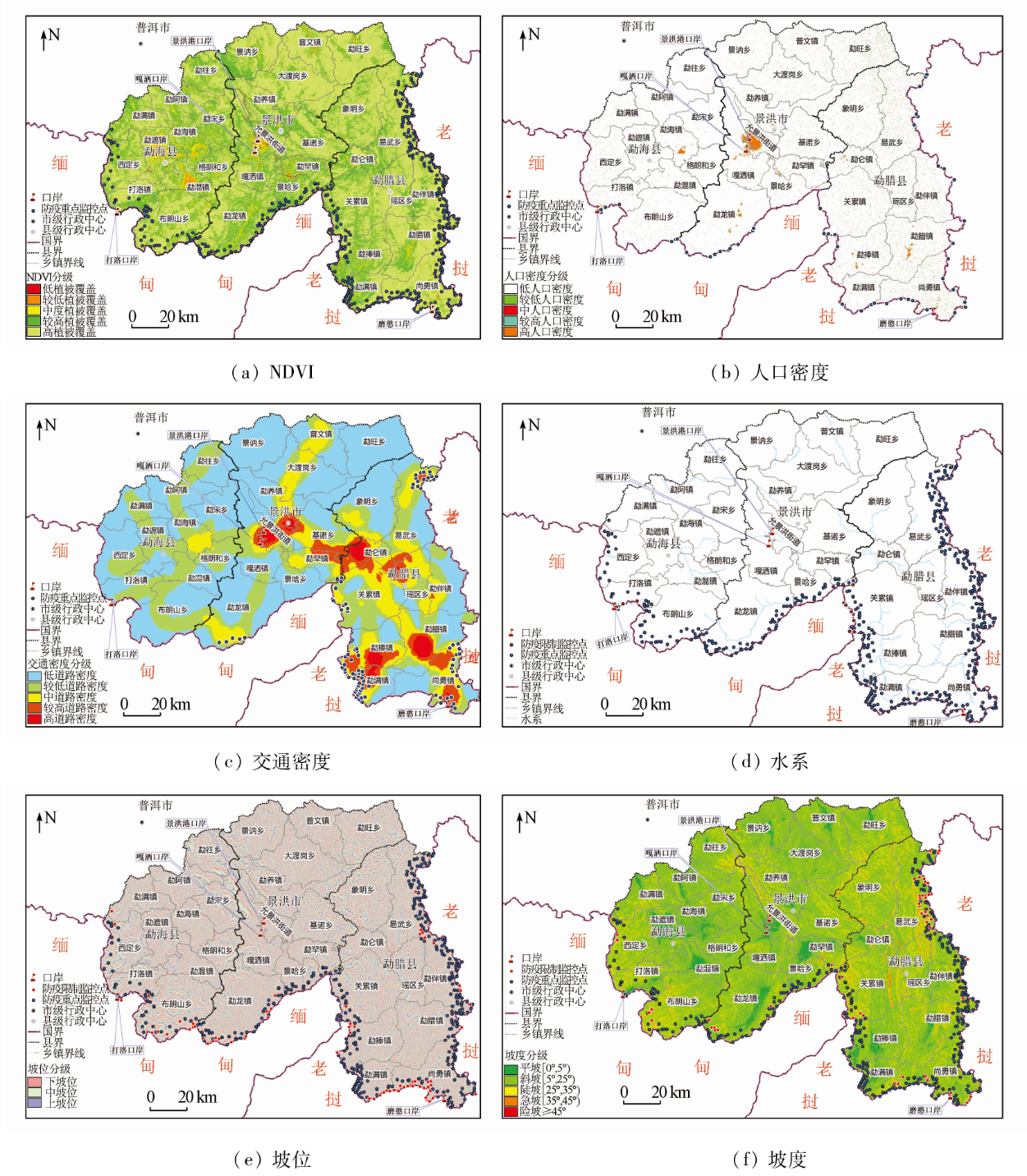
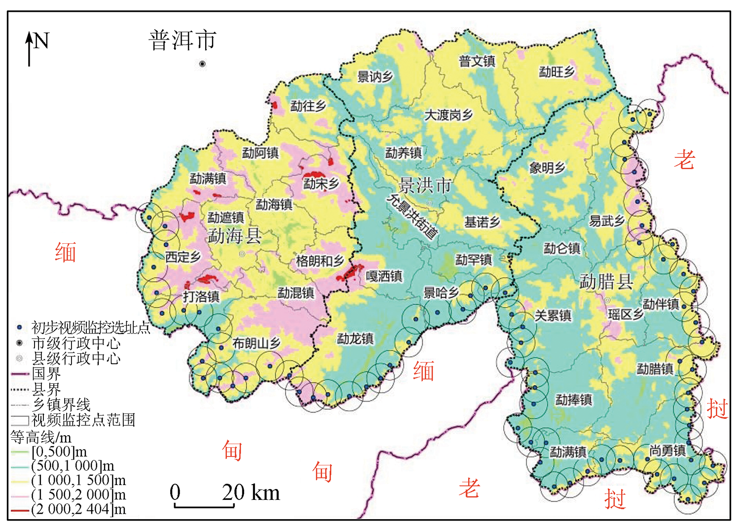
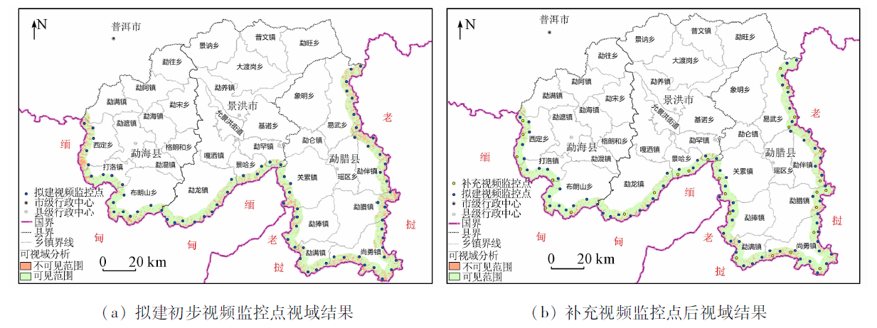
Abstract The deployment of video monitoring points for epidemic prevention in border areas is an important measure to deal with emergencies and has great significance for regional public health security. The deployment of video monitoring points mainly focused on cities in the past. Few studies concerned the deployment of video monitoring points based on the characteristics of border areas and emergency response needs. This study constructed a framework for the deployment of video monitoring points for epidemic prevention in the border area of Xishuangbanna Dai Autonomous Prefecture. The suitability and limiting factors of monitoring points were determined for the multi-round selection of monitoring points. More monitoring points were deployed properly in areas with low monitoring efficiency. Finally, the appropriate deployment sites for epidemic prevention monitoring points in Xishuangbanna were determined. The results are as follows. With the video monitoring points for epidemic prevention determined in this study, 93.3% of the area within 5 km of the Xishuangbanna border can be observed. Thus, information on people flow at the border can be comprehensively obtained. Compared with the conventional site selection methods using single-dimensional suitability, mathematical modeling, and algorithms, the proposed deployment method of video monitoring points for border epidemic prevention is more suitable for the actual situation of border areas and can give full play to the overall coordination level of the deployment of monitoring points. Besides, this proposed method avoids the complex application of conventional methods. Therefore, the site selection method of video monitoring points for epidemic prevention proposed in this study provides theoretical reference and technical support for current COVID-19 prevention in border areas, so as to ensure regional public health security and national sustainable development.
|
| Keywords
geographic information system
video monitoring point
site selection methods
visibility analysis
the border
|
|
|
|
Issue Date: 27 December 2022
|
|
|
| [1] |
杨晨, 文成, 许小可. 新冠肺炎疫情对民族地区人口流动的影响[J]. 电子科技大学学报, 2021, 50(6):938-946.
|
| [1] |
Yang C, Wen C, Xu X K. The COVID-19 impact on population flow of ethnic minority areas[J]. Journal of University of Electronic Science and Technology of China, 2021, 50(6):938-946.
|
| [2] |
赵梓渝, 韩钟辉, 魏冶, 等. 中国人口流动管控应对COVID-19疫情效应评估[J]. 地理学报, 2022, 77(2):426-442.
doi: 10.11821/dlxb202202011
|
| [2] |
Zhao Z Y, Han Z H, Wei Z, et al. Effect of population flow control in restraining COVID-19 in China[J]. Acta Geographica Sinica, 2022, 77(2):426-442.
doi: 10.11821/dlxb202202011
|
| [3] |
刘雪莲, 杨雪. 新时期维护我国边境安全的思路转向与精准治理[J]. 云南师范大学学报(哲学社会科学版), 2021, 53(5):21-32.
|
| [3] |
Liu X L, Yang X. China’s border security governance in the process of opening up:Dilemmas and solutions[J]. Journal of Yunnan Normal University(Humanities and Social Sciences Edition), 2021, 53(5):21-32.
|
| [4] |
程艺, 刘慧, 张芳芳. 中国边境口岸地区传染病境外输入风险评估——以新冠肺炎疫情为例[J]. 地理研究, 2022, 41(3):851-866.
doi: 10.11821/dlyj020201090
|
| [4] |
Cheng Y, Liu H, Zhang F F. Cross-border infections in border port areas of China:Take COVID-19 as an example[J]. Geographical Research, 2022, 41(3):851-866.
|
| [5] |
黄凯奇, 陈晓棠, 康运锋, 等. 智能视频监控技术综述[J]. 计算机学报, 2015, 38(6):1093-1118.
|
| [5] |
Huang K Q, Chen X T, Kang Y F, et al. Intelligent visual surveillance: A review[J]. Chinese Journal of Computers, 2015, 38(6):1093-1118.
|
| [6] |
张超, 刘亮. 无线视频监控系统在海外社会安全管理工作中的应用[J]. 中国安全生产科学技术, 2019, 15(s2):58-60.
|
| [6] |
Zhang C, Liu L. Application of wireless video monitoring system in overseas social security management[J]. Journal of Safety Science and Technology, 2019, 15(s2):58-60.
|
| [7] |
张健, 刘毅, 韩宁, 等. 鹫峰国家森林公园林火视频监控点的选址[J]. 东北林业大学学报, 2009, 37(5):24-27.
|
| [7] |
Zhang J, Liu Y, Han N, et al. Set fire video surveillance site in Community National Forest Park[J]. Journal of Northeast Forestry University, 2009, 37(5):24-27.
|
| [8] |
Domenikiotis C, Dalezios N R, Faraslis I. GIS-based weather Radar siting procedure in mountainous terrain[J]. Physics and Chemistry of the Earth, 2010, 35(1):35-42.
|
| [9] |
方磊, 何建敏. 应急系统优化选址的模型及其算法[J]. 系统工程学报, 2003(1):49-54.
|
| [9] |
Fang L, He J M. Optimal location model and algorithm of emergency systems[J]. Journal of Systems Engineering, 2003(1):49-54.
|
| [10] |
张铱莹. 多目标应急服务设施选址与资源配置问题研究[J]. 中国安全科学学报, 2011, 21(12):153-158.
|
| [10] |
Zhang Y Y. Research on location and distribution of multi-objective emergency resources[J]. China Safety Science Journal, 2011, 21(12):153-158.
|
| [11] |
O’Hanley J R, Scaparra M P, Garcia S. Probability chains:A general linearization technique for modeling reliability in facility location and related problems[J]. European Journal of Operational Research, 2013, 230(1):63-75.
doi: 10.1016/j.ejor.2013.03.021
url: https://linkinghub.elsevier.com/retrieve/pii/S037722171300249X
|
| [12] |
曾宇容, 王林, 王思睿. 基于混合果蝇优化算法的选址-库存-配送集成优化研究[J]. 运筹与管理, 2022, 31(3):24-30.
doi: 10.12005/orms.2022.0073
|
| [12] |
Zeng Y R, Wang L, Wang S R. Integrated optimization of location-inventory-delivery problem using hybrid fruit fly optimization algorithm[J]. Operations Research and Managemengt Science, 2022, 31(3):24-30.
|
| [13] |
徐吉智, 张新燕, 常喜强, 等. 基于PV曲线和改进遗传算法储能选址定容研究[J]. 太阳能学报, 2022, 43(1):263-268.
|
| [13] |
Xu J Z, Zhang X Y, Chang X Q, et al. Research on energy storage location and capacity determination based on PV curve and improved genetic algorithm[J]. Acta Energiate Solaris Sinica, 2022, 43(1):263-268.
|
| [14] |
罗佳欣, 何登旭. 基于改进郊狼优化算法的充电站选址定容规划[J]. 计算机应用研究, 2022, 39(3):751-757.
|
| [14] |
Luo J X, He D X. Site selection and capacity planning of charging station based on improved coyote optimization algorithm[J]. Application Research of Computers, 2022, 39(3):751-757.
|
| [15] |
彭大江, 叶春明, 赵灵玮. 改进的蝗虫优化算法在双目标应急物资中心选址问题中的应用[J]. 运筹与管理, 2022, 31(4):14-20.
doi: 10.12005/orms.2022.0107
|
| [15] |
Peng D J, Ye C M, Zhao L W. An improved grasshopper optimization algorithm in application of bi-objective location problem for emergency materials centers[J]. Operations Research and Management Science, 2022, 31(4):14-20.
|
| [16] |
胡金龙, 唐梦鸽, 罗明良, 等. 基于DEM的一体化山地特征要素提取[J]. 地球信息科学学报, 2020, 22(3):422-430.
doi: 10.12082/dqxxkx.2020.190558
|
| [16] |
Hu J L, Tang M G, Luo M L, et al. The extraction of characteristic elements of mountain based on DEM[J]. Journal of Geo-Information Science, 2020, 22(3):422-430.
|
| [17] |
熊礼阳, 汤国安, 杨昕, 等. 面向地貌学本源的数字地形分析研究进展与展望[J]. 地理学报, 2021, 76(3):595-611.
doi: 10.11821/dlxb202103008
|
| [17] |
Xiong L Y, Tang G A, Yang X, et al. Geomorphology-oriented digital terrain analysis:Progress and perspectives[J]. Acta Geographica Sinica, 2021, 76(3):595-611.
|
| [18] |
赖晨曦, 付蔚霞, 王海江, 等. 基于林火强度分析的森林防火监测点选址[J]. 测绘通报, 2021(s2):267-270.
|
| [18] |
Lai C X, Fu W X, Wang H J, et al. Location selection methods of forest fire monitoring points based on forest fire intensity analysis[J]. Bulletin of Surveying and Mapping, 2021(s2):267-270.
|
| [19] |
李雯静, 胡丹, 李楠. 基于地理场景的矿区监控选址模型[J]. 金属矿山, 2020(9):87-95.
|
| [19] |
Li W J, Hu D, Li N. Study on monitoring site selection model of mining area based on geographical scene[J]. Metal Mine, 2020(9):87-95.
|
| [20] |
吴浩, 黄创, 张建华, 等. GNSS/GIS集成的露天矿高边坡变形监测系统研究与应用[J]. 武汉大学学报(信息科学版), 2015, 40(5):706-710.
|
| [20] |
Wu H, Huang C, Zhang J H, et al. Deformation monitoring system for high slope in open pit mine with the integration of GNSS and GIS[J]. Geomatics and Information Science of Wuhan University, 2015, 40(5):706-710.
|
| [21] |
刘咏梅, 范鸿建, 盖星华, 等. 基于无人机高光谱影像的NDVI估算植被盖度精度分析[J]. 自然资源遥感, 2021, 33(3):11-17.doi:10.6046/zrzyyg.2020406.
doi: 10.6046/zrzyyg.2020406
|
| [21] |
Liu Y M, Fan H J, Gai X H, et al. Estimation accuracy of fractional vegetation cover based on normalized difference vegetation index and UAV hyperspectral images[J]. Remote Sening for Natural Resources, 2021, 33(3):11-17.doi:10.6046/zrzyyg.2020406.
doi: 10.6046/zrzyyg.2020406
|
| [22] |
布自强, 白林波, 张佳瑜. 基于夜光遥感的宁夏沿黄城市群时空演变[J]. 自然资源遥感, 2022, 34(1):169-176.doi:10.6046/zrzyyg.2021118.
doi: 10.6046/zrzyyg.2021118
|
| [22] |
Bu Z Q, Bai L B, Zhang J Y. Spatio - temporal evolution of Ningxia urban agglomeration along the Yellow River based on nighttime light remote sensing[J]. Remote Sening for Natural Resources, 2022, 34(1):169-176.doi:10.6046/zrzyyg.2021118.
doi: 10.6046/zrzyyg.2021118
|
| [23] |
高义, 王辉, 王培涛, 等. 基于人口普查与多源夜间灯光数据的海岸带人口空间化分析[J]. 资源科学, 2013, 35(12):2517-2523.
|
| [23] |
Gao Y, Wang H, Wang P T, et al. Population spatial processing for chinese coastal zones based on census and multiple night light data[J]. Resources Science, 2013, 35(12):2517-2523.
|
| [24] |
孙昂, 杨清华, 刘智, 等. 西里古里走廊地区道路交通:分布特征、通行能力与地质环境[J]. 自然资源遥感, 2021, 33(3):138-147.doi:10.6046/zrzyyg.2020421.
doi: 10.6046/zrzyyg.2020421
|
| [24] |
Sun A, Yang Q H, Liu Z, et al. Transportation in the Siliguri Corridor, West Bengal, India:Distribution characteristics,trafficability, and geological environment[J]. Remote Sensing for Natural Resources, 2021, 33(3):138-147.doi:10.6046/zrzyyg.2020421.
doi: 10.6046/zrzyyg.2020421
|
| [25] |
易明华, 吴辉, 叶柯. 地理国情的地质灾害危险性评价[J]. 测绘科学, 2017, 42(8):40-43.
|
| [25] |
Yi M H, Wu H, Ye K. Research on geological disaster’s safety evaluation based on geographical conditions information[J]. Science of Surveying and Mapping, 2017, 42(8):40-43.
|
| [26] |
于飞, 王得祥, 史晓晓, 等. 不同生态条件下松栎混交林3种优势乔木种群的更新规律[J]. 西北植物学报, 2013, 33(5):1020-1026.
|
| [26] |
Yu F, Wang D X, Shi X X, et al. Regeneration rules of three dominant tree species in a pine oak mixed forest under different ecological conditions in the Qinling mountains[J]. Acta Botanica Boreali-Occidentalia Sinica, 2013, 33(5):1020-1026.
|
| [27] |
张跃红, 安裕伦, 马良瑞, 等. 1960—2010年贵州省喀斯特山区陡坡土地利用变化[J]. 地理科学进展, 2012, 31(7):878-884.
|
| [27] |
Zhang Y H, An Y L, Ma L R, et al. Land use change of slope I and in Karst mountainous regions, Guizhou Province during 1960—2010[J]. Progress in Geography, 2012, 31(7):878-884.
|
| [28] |
亢晓丽, 亢晓琛. 大规模DEM数据并行可视域分析算法研究[J]. 计算机测量与控制, 2014, 22(6):1970-1972.
|
| [28] |
Kang X L, Kang X C. Parallel viewshed analysis on large scale DEM data[J]. Computer Measurement and Control, 2014, 22(6):1970-1972.
|
| [29] |
靳海亮, 李留磊, 袁松鹤, 等. 一种用于三维城市建筑物的可视域分析算法[J]. 测绘通报, 2018(1):103-106.
|
| [29] |
Jin H L, Li L L, Yuan S H, et al. A viewshed analysis algorithm for 3D urban buildings[J]. Bulletin of Surveying and Mapping, 2018(1):103-106.
|
| [30] |
廖恒昌. 远距离激光夜视监控系统的设计、实现及其应用[D]. 云南: 云南大学, 2015.
|
| [30] |
Liao H C. Design, implementation and application of remote laser night vision monitoring system[D]. Yunnan: Yunnan University, 2015.
|
| [31] |
米先润. 港口远距离昼夜视频监控系统解决方案[J]. 中国安防, 2015(8):102-105.
|
| [31] |
Mi X R. Port remote day and night video monitoring system solutions[J]. China Security and Protection, 2015(8):102-105.
|
| [32] |
曹黎俊, 黄凯奇. 大范围视频监控下的人群密度估计和预测系统(英文)[J]. 中国通信, 2013, 10(5):79-88.
|
| [32] |
Cao L J, Huang K Q. Video-based crowd density estimation and prediction system for wide-area surveillance[J]. China Communications, 2013, 10(5):79-88.
|
|
Viewed |
|
|
|
Full text
|
|
|
|
|
Abstract
|
|
|
|
|
Cited |
|
|
|
|
| |
Shared |
|
|
|
|
| |
Discussed |
|
|
|
|
 2022,
Vol. 34
2022,
Vol. 34