|
|
 |
|

|
|
|
Risks and the prevention and control deployment of COVID-19 infection along the border of Ruili City based on the AHP-entropy weight method |
LI Yimin1,2( ), WU Bowen1, LIU Shiyi1, LI Yingying1, YUAN Jing1 ), WU Bowen1, LIU Shiyi1, LI Yingying1, YUAN Jing1 |
1. School of Earth Sciences, Yunnan University, Kunming 650500, China
2. Remote Sensing Geological Engineering Research Center for Domestic Gaofen Satellite of Yunnan Universities, Kunming 650500, China |
|
|
|
|
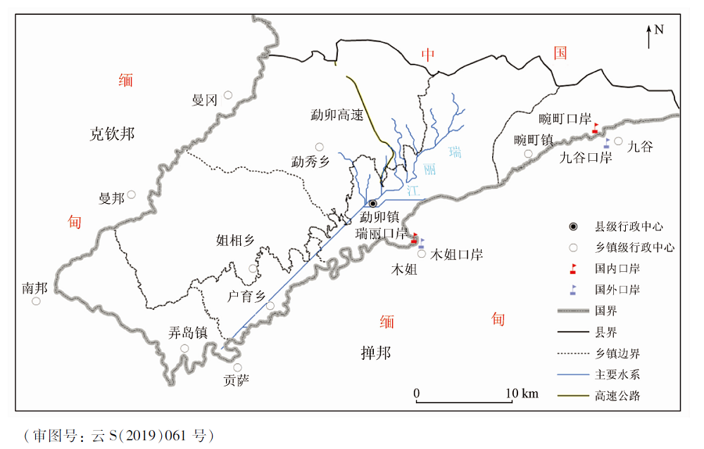
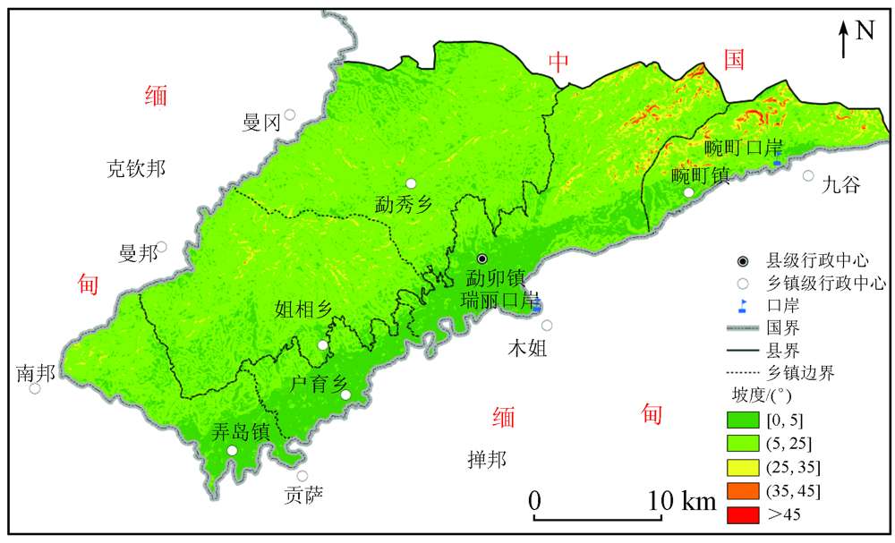
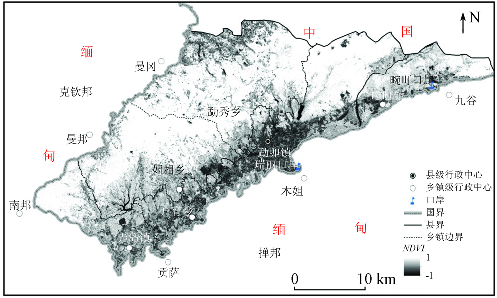
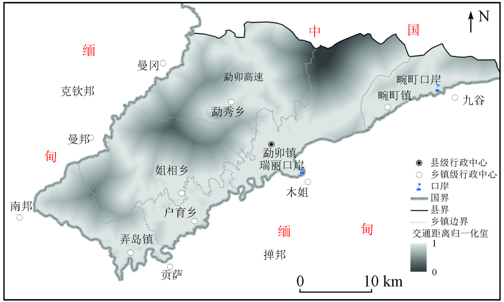
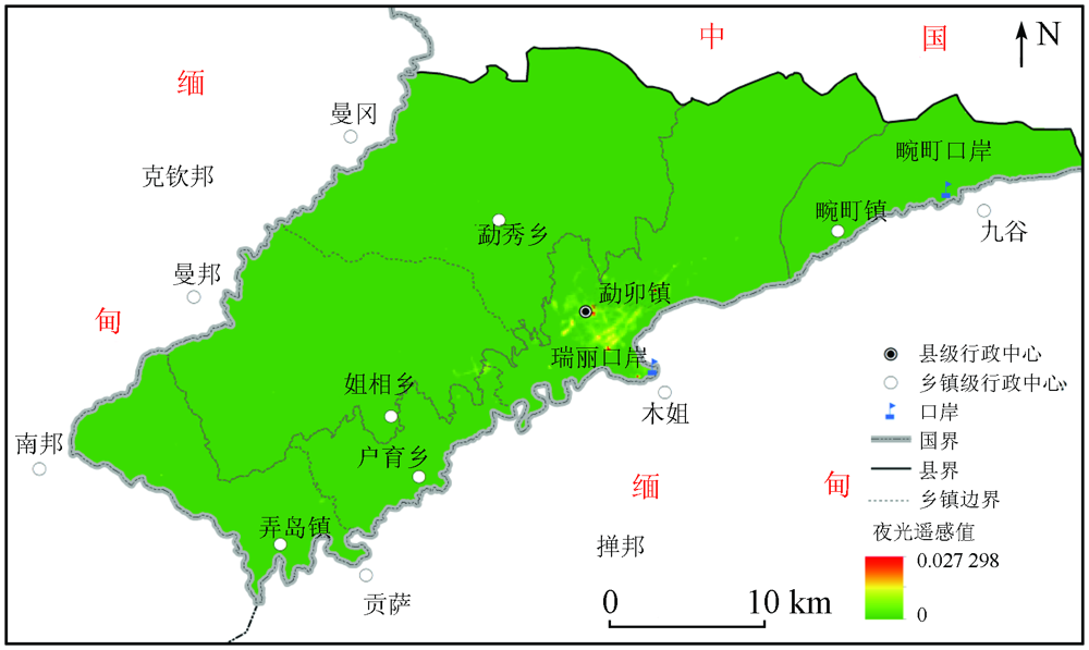
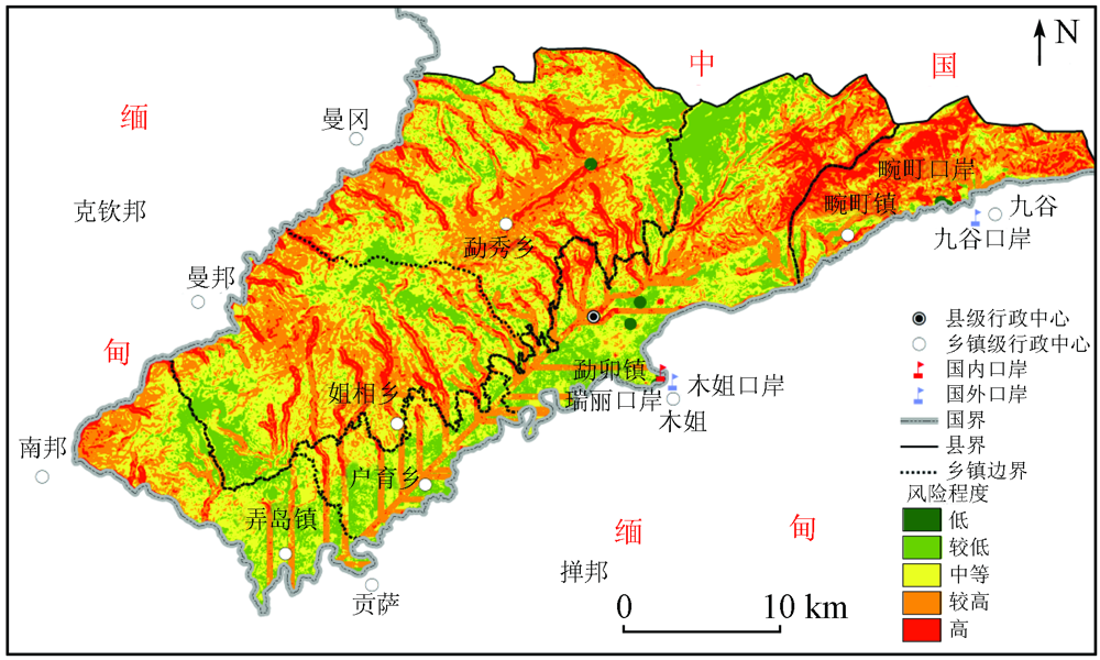
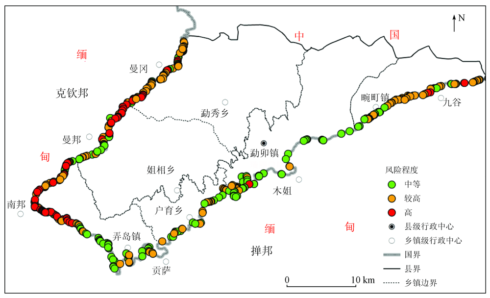
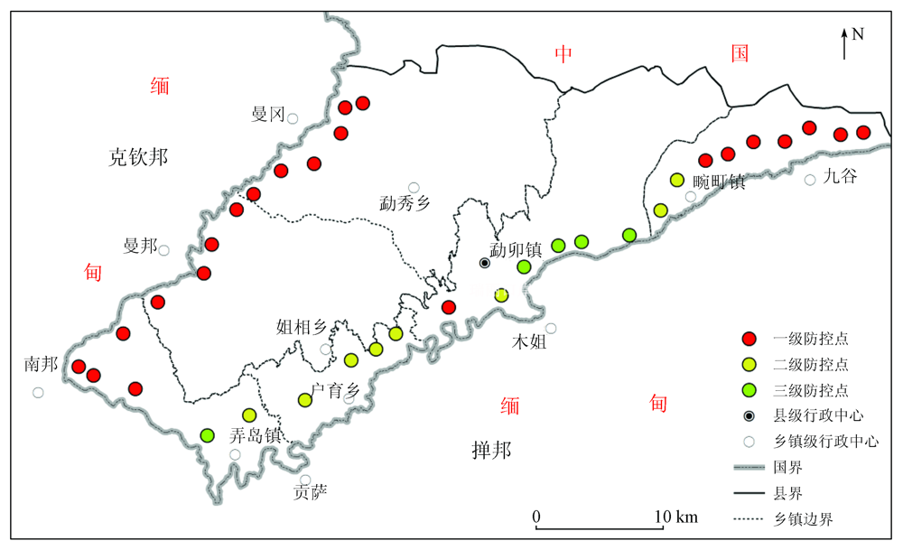
Abstract Although the COVID-19 pandemic has been contained in China presently, it remains a major threat to the international environment. The border areas of China remain at high risk of COVID-19 infection, including Ruili, an important port city on the border between China and Myanmar, which still faces great challenges in pandemic prevention and control along the border. This study analyzed the topographic, traffic, and basic factors of Ruili using the GIS technology, the remote sensing technology, and the AHP-entropy weight method and identified locations with high risks of the pandemic along the border, aiming to achieve more scientific the pandemic prevention and control. The results showed that the high-risk areas in Ruili that need major pandemic prevention and control were in the southwestern and southern zones near the border and had the following characteristics: ① gentle terrain with high fractional vegetation cover; ② convenient transportation and proximity to water systems; ③ high settlement density. To achieve a complete observation of the border, a total of 35 prevention and control points were deployed based on the set covering location model combined with the ArcGIS viewshed analysis. They were divided into 22 primary, 8 secondary, and 5 tertiary prevention and control points, of which the importance of pandemic prevention and control increased gradually. This study can provide references for improving the pandemic prevention and control capacity of border areas.
|
| Keywords
prevention and control along the border
Ruili City
COVID-19 pandemic
|
|
|
|
Issue Date: 21 September 2022
|
|
|
| [1] |
Hernandez J H, Karletsos D, Avegno J, et al. Is Covid-19 community level testing effective in reaching at-risk populations? Evidence from spatial analysis of New Orleans patient data at walk-up sites[J]. BMC Public Health, 2021, 21:632.
doi: 10.1186/s12889-021-10717-9
pmid: 33789647
|
| [2] |
Mas J F. Spatio-temporal dataset of COVID-19 outbreak in Mexico[J]. Data in Brief, 2021, 35:106843.
doi: 10.1016/j.dib.2021.106843
url: https://linkinghub.elsevier.com/retrieve/pii/S235234092100127X
|
| [3] |
程艺, 刘慧, 刘海猛, 等. 中国边境口岸地区传染病境外输入风险评估——以新冠肺炎疫情为例[J]. 地理研究, 2022, 41(3):851-866.
doi: 10.11821/dlyj020201090
|
| [3] |
Cheng Y, Liu H, Liu H M, et al. Cross-border epidemic importation in China’s border port area:Take COVID-19 as an example[J]. Geographical Research, 2022, 41(3):851-866.
|
| [4] |
李益敏, 袁静, 赵志芳. 基于GIS的中缅边境地区突发事件防控研究[J]. 云南地理环境研究, 2020, 32(3):1-7.
|
| [4] |
Li Y M, Yuan J, Zhao Z F. GIS-based study on prevention and control of frontier inflex of emergencies in China-Myanmar border area[J]. Yunnan Geographic Environment Research, 2020, 32(3):1-7.
|
| [5] |
罗刚. 云南边境民族地区人口非法流动法治对策研究[J]. 河北法学, 2011, 29(9):184-191.
|
| [5] |
Luo G. Research on legal counter-measures against unlawful movement of population on bordering ethnic habitat regions in Yunnan[J]. Hebei Science, 2011, 29(9):184-191.
|
| [6] |
Dudas G, Carvalho L M, Bedford T, et al. Virus genomes reveal factors that spread and sustained the Ebola epidemic[J]. Nature, 2017, 7650(544):309-315.
|
| [7] |
Palk L, Okano J T, Dullie L, et al. Travel time to health-care facilities,mode of transportation,and HIV elimination in Malawi:A geospatial modelling analysis[J]. Lancet Global Health, 2020, 12(8):1555-1664.
|
| [8] |
王正兴, 刘闯, Alfredo H. 植被指数研究进展:从AVHRR-NDVI到MODIS-EVI[J]. 生态学报, 2003(5):979-987.
|
| [8] |
Wang Z X, Liu C, Alfredo H. From AVHRR-NDVI to MODIS-EVI:Advances in vegetation index research[J]. Acta Ecologica Sinica, 2003(5):979-987.
|
| [9] |
汪韬阳, 张过, 李沛然, 等. 基于DMSP/OLS夜光遥感影像的城市扩张政策驱动因素分析[J]. 测绘学报, 2018, 47(11):1466-1473.
|
| [9] |
Wang T Y, Zhang G, Li P R, et al. Analysis on the driving factors of urban expansion policy based on DMSP/OLS remote sensing image[J]. Acta Geodaetica et Cartographica Sinica, 2018, 47(11):1466-1473.
|
| [10] |
孙小芳. 夜光遥感支持下的城市人口核密度空间化及自相关分析[J]. 地球信息科学学报, 2020, 22(11):2256-2266.
doi: 10.12082/dqxxkx.2020.200289
|
| [10] |
Sun X F. Spatialization and autocorrelation analysis of urban population kernel density supported by nighttime light remote sensing[J]. Journal of Geoinformation Science, 2020, 22(11):2256-2266.
|
| [11] |
程启月. 评测指标权重确定的结构熵权法[J]. 系统工程理论与实践, 2010, 30(7):1225-1228.
doi: 10.12011/1000-6788(2010)7-1225
|
| [11] |
Cheng Q Y. Structure entropy weight method to confirm the weight of evaluting index[J]. System Engineering-Theory&Practice, 2010, 30(7):1225-1228.
|
| [12] |
章穗, 张梅, 迟国泰. 基于熵权法的科学技术评价模型及其实证研究[J]. 管理学报, 2010, 7(1):34-42.
|
| [12] |
Zhang S, Zhang M, Chi G T. The science and technology evaluation model based on entropy weight and empirical research during the 10th five-year of China[J]. Chinese Journal of Management, 2010, 7(1):34-42.
|
| [13] |
熊俊楠, 曹依帆, 孙铭, 等. 基于GIS和熵权法的滑坡作用下的长输油气管道易损性评价[J]. 山地学报, 2020, 38(5):717-725.
|
| [13] |
Xiong J N, Cao Y F, Sun M, et al. Vulnerability evaluation of long-distance oil and gas pipelines under landslide actions based on GIS and entropy weight method[J]. Mountain Research, 2020, 38(5):717-725.
|
| [14] |
刘媛媛, 王绍强, 王小博. 基于AHP-熵权法的孟印缅地区洪水灾害风险评估[J]. 地理研究, 2020, 39(8):1892-1906.
doi: 10.11821/dlyj020190679
|
| [14] |
Liu Y Y, Wang S Q, Wang X B. Flood risk assessment in Bangladesh,India and Myanmar based on the AHP weight method and entropy weight method[J]. Geographical Research, 2020, 39(8):1892-1906.
|
| [15] |
乔联宝. 覆盖类选址问题分类及研究综述[J]. 物流科技, 2015, 38(3):59-66.
|
| [15] |
Qiao L B. Classification and review on the covering facility location problem[J]. Logistics Sci-Tech, 2015, 38(3):59-66.
|
| [16] |
吴明珠. 自然保护区视频监控点的优化选址研究[D]. 上海: 华东师范大学, 2016.
|
| [16] |
Wu M Z. Research on the optimal location of video monitoring for nature reserves Example as Jiaozishan Nature Reserve in Yunnan,China[D]. Shanghai: East China Normal University, 2016.
|
| [17] |
Toregas C, Swain R, ReVelle C, et al. The location of emergency services facilities[J]. Operations Research, 1971, 19:1363-1373.
doi: 10.1287/opre.19.6.1363
url: http://pubsonline.informs.org/doi/10.1287/opre.19.6.1363
|
| [18] |
戴永红, 刘金卫. 缅甸民地武新联盟的形成、发展与未来走向[J]. 国际论坛, 2016, 18(4):64-71.
|
| [18] |
Dai Y H, Liu J W. Myanner’s new alliance of ethinc armed groups:Formation,development and future trends[J]. International Forum, 2016, 18(4):64-71.
|
|
Viewed |
|
|
|
Full text
|
|
|
|
|
Abstract
|
|
|
|
|
Cited |
|
|
|
|
| |
Shared |
|
|
|
|
| |
Discussed |
|
|
|
|
 2022,
Vol. 34
2022,
Vol. 34