|
|
 |
|

|
|
|
Spatial-temporal evolution characteristics and prediction of land subsidence in the eastern plain of Beijing |
YU Wen1,2,3,4( ), GONG Huili1,2,3,4(), CHEN Beibei1,2,3,4, ZHOU Chaofan1,2,3,4 ), GONG Huili1,2,3,4(), CHEN Beibei1,2,3,4, ZHOU Chaofan1,2,3,4 |
1. Beijing Laboratory of Water Resources Security, Capital Normal University, Beijing 100048, China
2. Key Laboratory of Land Subsidence Mechanism and Control, Ministry of Education, Capital Normal University, Beijing 100048, China
3. Base of the State Key Laboratory of Urban Environmental Process and Digital Modeling, Capital Normal University, Beijing 100048, China
4. National Field Scientific Observation and Research Station of Groundwater and Land Subsidence in the Beijing-Tianjin-Hebei Plain, Capital Normal University, Beijing 100048, China |
|
|
|
|
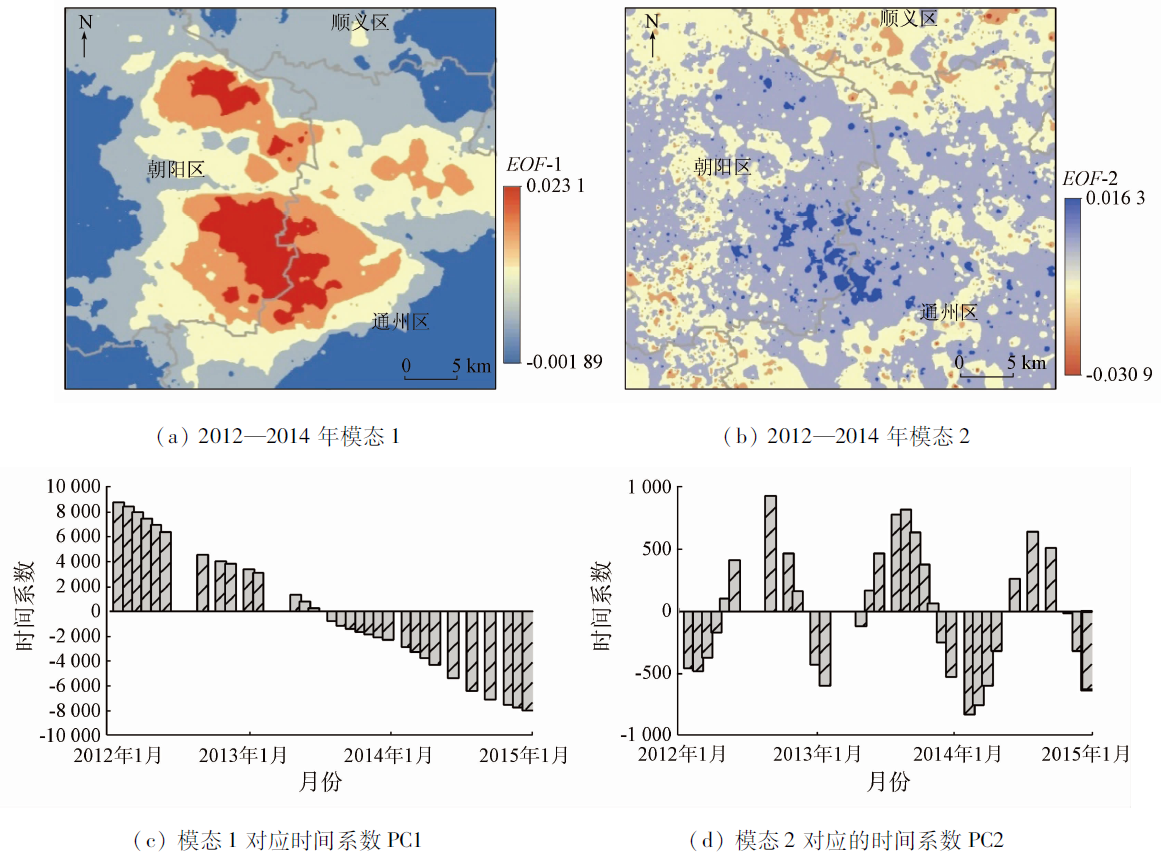
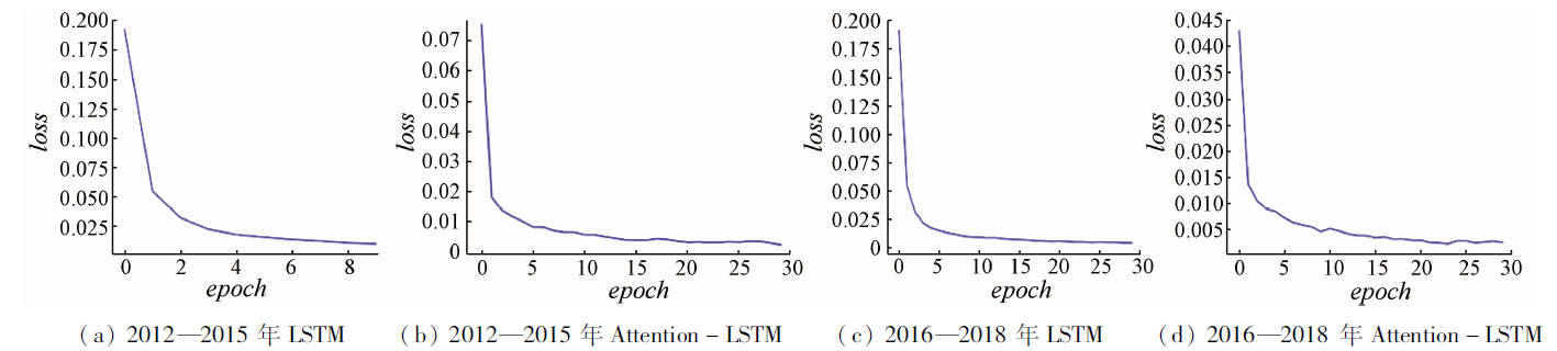
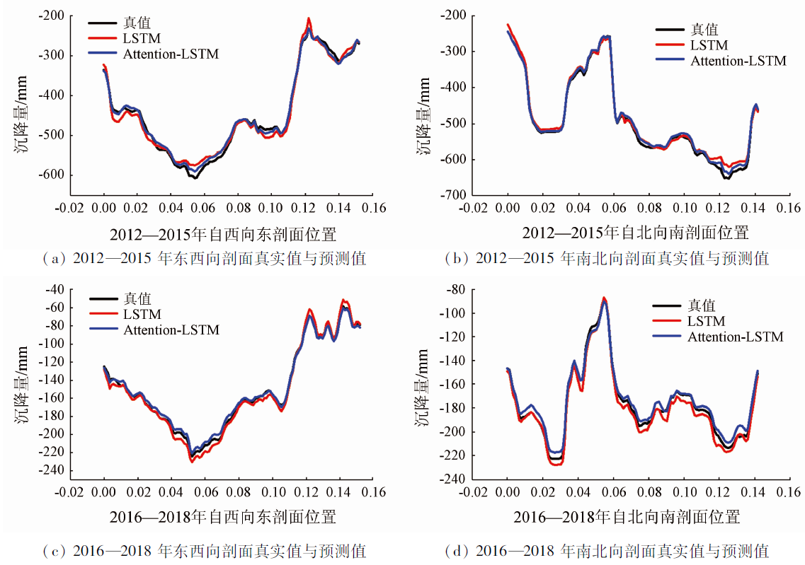
Abstract Land subsidence is a natural geological phenomenon in which the surface elevation drops. It can severely destroy urban infrastructure and threaten urban safety if it occurs in densely populated cities with a high social development degree. The analysis of the evolution characteristics of land subsidence can reflect the degree of the influence of land subsidence on the ground infrastructures, and building an efficient land subsidence prediction model is of great significance for preventing and controlling land subsidence and protecting urban safety. This study obtained the spatial-temporal information on land subsidence using the persistent scatterer interferometric synthetic aperture Radar (PS-InSAR) method first and then verified the information using leveling to get high precision. Then, this study analyzed the general spatial-temporal characteristics of the land subsidence field using an empirical orthogonal function. The analysis results are as follows. Spatial modal No. 1 had a high variance contribution rate, almost representing the general spatial evolution of the study area. Its corresponding time coefficient showed a significant linear trend. By contrast, spatial mode No. 2 had a low variance contribution rate and a seasonally significant time coefficient. Finally, the time series of the regional land subsidence were predicted using both long short-term memory (LSTM) and Attention-LSTM models. The prediction results indicate that the Attention-LSTM model was superior to the LSTM model, with the mean square error loss (MSE-loss) of as low as 0.01. This prediction method expands the application of deep learning in the study of land subsidence.
|
| Keywords
land subsidence
empirical orthogonal function
evolution characteristics
Attention-LSTM
time series prediction
|
|
|
|
Issue Date: 27 December 2022
|
|
|
| [1] |
周飞飞. 《全国地面沉降防治规划(2011—2020年)》解读——访国土资源部地质环境司副司长陶庆法[J]. 中国应急管理, 2012(3):58-61.
|
| [1] |
Zhou F F. Interpretation of the national plan for land subsidence prevention and control (2011—2020):Interview with Tao Qingfa,deputy director of the department of geological environment,Ministry of Land and Resources[J]. China Emergency Management, 2012(3):58-61.
|
| [2] |
叶晓宾. 华北平原地面沉降经济损失评估[M]. 北京: 中国大地出版社, 2006.
|
| [2] |
Ye X B. Evaluation of economic loss of land subsidence in the North China Plain[M]. Beijing: China Land Publishing House, 2006.
|
| [3] |
刘国祥. InSAR系列讲座6 InSAR应用实例及其局限性分析[J]. 四川测绘, 2005, 28(3):139-143.
|
| [3] |
Liu G X. Application examples of InSAR and its limitation analysis[J]. Surveying and Mapping of Sichuan, 2005, 28(3):139-143.
|
| [4] |
Zebker H A, Goldstein R M. Topographic mapping from interferometric synthetic aperture Radar observations[J]. Journal of Geophysical Research Solid Earth, 1986, 91(b5):4993-4999.
|
| [5] |
Massonnet D, Rossi M, Carmona C, et al. The displacement field of the Landers earthquake mapped by Radar interferometry[J]. Nature, 1993, 364(6433):138-142.
doi: 10.1038/364138a0
url: https://doi.org/10.1038/364138a0
|
| [6] |
宫辉力, 张有全, 李小娟. 基于永久散射体雷达干涉测量技术的北京市地面沉降研究[J]. 自然科学进展, 2009, 19(11):1261-1266.
|
| [6] |
Gong H L, Zhang Y Q, Li X J. Beijing land subsidence research based on permanent scatterer Radar interferometry technology[J]. Advances in Natural Science, 2009, 19(11):1261-1266.
|
| [7] |
Gabriel A K, Goldstein R M, Zebker H A. Mapping small elevation changes over large areas:Differential Radar interferometry[J]. Journal of Geophysical Research:Solid Earth, 1989, 94(b7):9183-9191.
|
| [8] |
Hanssen R F. Radar interferometry[M]. Springer Netherlands, 2001.
|
| [9] |
Ghiglia D C, Pritt M D. Two-dimensional phase unwrapping[M]. Wiley-Interscience, 1985.
|
| [10] |
Zebker H A, Rosen P A, Hensley S. Atmospheric effects in interfero-metric synthetic aperture Radar surface deformation and topographic maps[J]. Journal of Geophysical Research Solid Earth, 1997, 102(b4):7547-7563.
|
| [11] |
Ferretti A, Prati C. Nonlinear subsidence rate estimation using permanent scatterers in differential SAR interferometry[J]. IEEE Transactions on Geoscience and Remote Sensing, 2000, 38(5):2202-2212.
doi: 10.1109/36.868878
url: http://ieeexplore.ieee.org/document/868878/
|
| [12] |
周超凡, 宫辉力, 陈蓓蓓, 等. 北京市典型地区地面沉降空间格局分析[J]. 遥感信息, 2017, 32(4):24-29.
|
| [12] |
Zhou C F, Gong H L, Chen B B, et al. Spatial pattern of land subsidence in Beijing typical areas[J]. Remote Sensing Information, 2017, 32(4):24-29.
|
| [13] |
Zuo J J, Gong H L, Chen B B, et al. Time-series evolution patterns of land subsidence in the Eastern Beijing Plain,China[J]. Remote Sensing, 2019, 11(5): 539.
doi: 10.3390/rs11050539
url: https://www.mdpi.com/2072-4292/11/5/539
|
| [14] |
杨翠玉, 王彦兵, 赵亚丽, 等. 北京来广营地区地面沉降时空演化特征[J]. 遥感信息, 2020, 35(5):138-143.
|
| [14] |
Yang C Y, Wang Y B, Zhao Y L, et al. Temporal and spatial characteristics of land subsidence in Laiguangying,Beijing[J]. Remote Sensing Information, 2020, 35(5):138-143.
|
| [15] |
Zhou Q H, Hu Q W, Ai M Y, et al. An improved GM (1,3) model combining terrain factors and neural network error correction for urban land subsidence prediction[J]. Geomatics Natural Hazards and Risk, 2020, 11:212-229.
doi: 10.1080/19475705.2020.1716860
url: https://www.tandfonline.com/doi/full/10.1080/19475705.2020.1716860
|
| [16] |
Nie L, Wang H, Xu Y, et al. A new prediction model for mining subsidence deformation:The arc tangent function model[J]. Natural Hazards, 2015, 75(3):2185-2198.
doi: 10.1007/s11069-014-1421-z
url: http://link.springer.com/10.1007/s11069-014-1421-z
|
| [17] |
杨天亮, 许言. 国际地面沉降与城市安全研究动态——第一届国际城市地质学术研讨会综述[J]. 上海国土资源, 2017, 38(2):1-3.
|
| [17] |
Yang T L, Xu Y. Research trends in international land subsidence and urban security:An overview of the first international symposium on urban geology[J]. Shanghai Land and Resources, 2017, 38(2):1-3.
|
| [18] |
Deng Z, Ke Y, Gong H, et al. Land subsidence prediction in Beijing based on PS-InSAR technique and improved Grey-Markov model[J]. Giscience and Remote Sensing, 2017, 54(6):1-22.
doi: 10.1080/15481603.2016.1245822
url: https://www.tandfonline.com/doi/full/10.1080/15481603.2016.1245822
|
| [19] |
刘青豪, 张永红, 邓敏, 等. 大范围地表沉降时序深度学习预测法[J]. 测绘学报, 2021, 50(3):396-404.
|
| [19] |
Liu Q H, Zhang Y H, Deng M, et al. Time series prediction method of large-scale surface subsidence based on deep learning[J]. Acta Geodaetica et Cartographica Sinica, 2021, 50(3):396-404.
|
| [20] |
岳振华, 沈涛, 毛曦, 等. 循环神经网络的地面沉降预测方法[J]. 测绘科学, 2020, 45(12):149-156.
|
| [20] |
Yue Z H, Shen T, Mao X, et al. Ground subsidence prediction method based on recurrent neural network[J]. Science of Surveying and Mapping, 2020, 45(12):149-156.
|
| [21] |
刘予. 北京市地面沉降区含水层和压缩层组划分及地面沉降自动监测系统[D]. 长春: 吉林大学, 2004.
|
| [21] |
Liu Y. Divided water-bearing zones and compressible zones of Beijing land subsidence area and land subsidence automatic monitoring system[D]. Changchun: Jilin University, 2004.
|
| [22] |
周毅, 罗郧, 郭高轩, 等. 冲洪积平原地面沉降特征及主控因素——以北京平原为例[J]. 地质通报, 2016, 35(12):2100-2110.
|
| [22] |
Zhou Y, Luo Y, Guo G X, et al. A study of the characteristics of land subsidence and the main control factors in the alluvial plain:A case study of Beijing Plain[J]. Geological Bulletin of China, 2016, 35(12):2100-2110.
|
| [23] |
程凌鹏, 王新惠, 张琦伟, 等. 南水进京对北京地面沉降的影响及趋势分析[J]. 人民黄河, 2018, 40(5):93-97.
|
| [23] |
Cheng L P, Wang X H, Zhang Q W, et al. Influence of transferring Yangtze River water into Beijing on ground subsidence and trend analysis[J]. Yellow River, 2018, 40(5):93-97.
|
| [24] |
刘媛媛. 基于多源SAR数据的时间序列InSAR地表形变监测研究[D]. 西安: 长安大学, 2014.
|
| [24] |
Liu Y Y. Research on time series InSAR surface deformation monitoring based on multi-source SAR Data[D]. Xi’an: Chang’an University, 2014.
|
| [25] |
Lorenz E N. Empirical orthogonal functions and statistical weather prediction[M]. Cambridge: Massachusetts Institute of Technology, Department of Meteorology, 1956:1,52.
|
| [26] |
Asoka A, Gleeson T, Wada Y, et al. Relative contribution of monsoon precipitation and pumping to changes in groundwater storage in India[J]. Nature Geoscience, 2017, 10(2):109-117.
doi: 10.1038/ngeo2869
url: https://doi.org/10.1038/ngeo2869
|
| [27] |
Smith T M, Reynolds R W, Livezey R E, et al. Reconstruction of historical sea surface temperatures using empirical orthogonal functions[J]. Journal of Climate, 1996, 9(6):1403-1420.
doi: 10.1175/1520-0442(1996)009<1403:ROHSST>2.0.CO;2
url: http://journals.ametsoc.org/doi/10.1175/1520-0442(1996)009<1403:ROHSST>2.0.CO;2
|
| [28] |
Bianchi F M, Maiorino E, Kampffmeyer M C, et al. Recurrent neural networks for short-term load forecasting:An overview and comparative analysis[EB/OL].(2017-05-11) [2018-07-20] https://arxiv.org/pdf/1705.04378.pdf .
url: https://arxiv.org/pdf/1705.04378.pdf
|
|
Viewed |
|
|
|
Full text
|
|
|
|
|
Abstract
|
|
|
|
|
Cited |
|
|
|
|
| |
Shared |
|
|
|
|
| |
Discussed |
|
|
|
|
 2022,
Vol. 34
2022,
Vol. 34