|
|
 |
|

|
|
|
Extraction and analysis of soil salinization information of Alar reclamation area based on spectral index modeling |
DAI Yunhao1( ), GUAN Yao1, FENG Chunyong2, JIANG Min1, HE Xinghong1() ), GUAN Yao1, FENG Chunyong2, JIANG Min1, HE Xinghong1() |
1. College of Water Conservancy and Architecture Engineering, Tarim University, Alar 843300, China
2. Department of Geographical Sciences, Beijing Normal University, Beijing 100088, China |
|
|
|
|
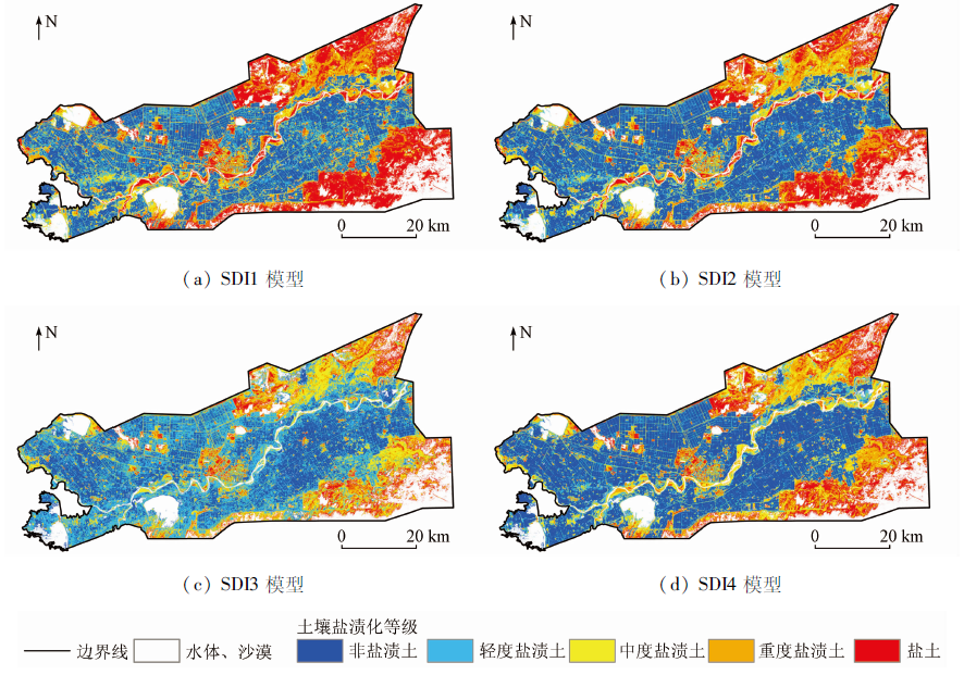
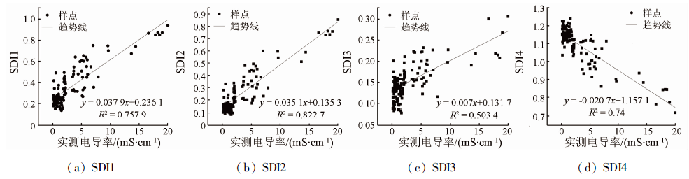
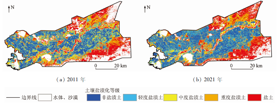
Abstract This study aims to explore the optimal remote sensing salinization detection index (SDI) model for the inversion of soil salinization in the Alar reclamation area. Based on Landsat8 OLI remote sensing images and field measured data, this study built the remote sensing SDI models using the salinity index (SI), the normalized difference vegetation index (NDVI), the modified soil adjusted vegetation index (MSAVI), and the surface albedo. Then, using these models, this study extracted the soil salinization information on the Alar reclamation area and verified the model precision. Finally, this study determined the optimal remote sensing-based SDI model through comparative analysis. The results are as follows. The four types of remote sensing-based SDI models SDI1 (SI-NDVI), SDI2 (SI-MSAVI), SDI3 (SI-Albedo), and SDI4 (Albedo-MSAVI)had general classification precision of 83.45%, 69.78%, 53.23%, and 71.94%, respectively. Model SDI1 was the most suitable for the inversion of the degree of soil salinization in the Alar reclamation area. Models SDI2 and SDI4 can be utilized as a reference for soil salinization monitoring of the Alar reclamation area. As revealed by the inversion results of the SDI model, the reclamation area is dominated by non-saline and lightly saline soils, with heavily saline soil and saline soil primarily distributed in the northeast and southeast. Model SDI1 established based on SI and NDVI has high accuracy in extracting the soil salinization information of the Alar reclamation area and can be used as the remote sensing-based SDI model for the inversion of soil salinization in reclamation areas. This study can provide an effective technical reference for the control and prevention of soil salinization.
|
| Keywords
spectral index
Alar reclamation area
soil salinization
remote sensing salinity detection index model
|
|
|
|
Issue Date: 20 March 2023
|
|
|
| [1] |
麦麦提吐尔逊·艾则孜. 绿洲土壤盐渍化及水盐调控[M]. 北京: 北京理工大学出版社, 2016.
|
| [1] |
Aizezi M. Soil salinization and water salt regulation in oasis[M]. Beijing: Beijing University of Technology Press, 2016.
|
| [2] |
买买提·沙吾提, 尼格拉·塔什甫拉提, 丁建丽, 等. 干旱区土壤盐渍化遥感监测及评价研究[M]. 北京: 北京理工大学出版社, 2018.
|
| [2] |
Shatiwu M, Tashenpulati N, Ding J L, et al. Remote sensing monitoring and evaluation of soil salinization in arid areas[M]. Beijing: Beijing University of Technology Press, 2018.
|
| [3] |
贾萍萍, 尚天浩, 张俊华, 等. 利用多源光谱信息反演宁夏银北地区干湿季土壤含盐量[J]. 农业工程学报, 2020, 36(17):125-134.
|
| [3] |
Jia P P, Shang T H, Zhang J H, et al. Inversion of soil salinity in dry and wet seasons based on multi-source spectral data inYinbei area of Ningxia,China[J]. Transactions of the Chinese Society of Agricultural Engineering, 2020, 36(17):125-134.
|
| [4] |
虎胆·吐马尔白, 赵永成, 马合木江·艾合买提, 等. 北疆常年膜下滴灌棉田土壤盐分积累特征研究[J]. 灌溉排水学报, 2016, 35(1):1-5.
|
| [4] |
Tumaerbai H, Zhao Y C, Aihemaiti M, et al. Study on characteristics of cotton field soil salt accumulation under perennialmulched drip irrigation in Northern Xinjiang[J]. Journal of Irrigation and Drainage, 2016, 35(1):1-5.
|
| [5] |
吴亚坤, 刘广明, 苏里坦, 等. 多源数据的区域土壤盐渍化精确评估[J]. 光谱学与光谱分析, 2018, 38(11):3528-3533.
|
| [5] |
Wu Y K, Liu G M, Shu L T, et al. Accurate evaluation of regional soil salinization using multi-source data[J]. Spectroscopy and Spectral Analysis, 2018, 38(11):3528-3533.
|
| [6] |
Alqasemi A S, Ibrahim M, Al-Quraishi A M F, et al. Detection and modeling of soil salinity variations in arid lands using remote sensing data[J]. Open Geosciences, 2021, 13(1):443-453.
doi: 10.1515/geo-2020-0244
url: https://www.degruyter.com/document/doi/10.1515/geo-2020-0244/html
|
| [7] |
Sidike A, Zhao S, Wen Y. Estimating soil salinity in Pingluo County of China using QuickBird data and soil reflectance spectra[J]. International Journal of Applied Earth Observation and Geoinformation, 2014, 26:156-175.
doi: 10.1016/j.jag.2013.06.002
url: https://linkinghub.elsevier.com/retrieve/pii/S0303243413000743
|
| [8] |
Wang F, Chen X, Luo G P, et al. Detecting soil salinity with arid fraction integrated index and salinity index in feature space using Landsat TM imagery[J]. Journal of Arid Land, 2013, 5(3):340-353.
doi: 10.1007/s40333-013-0183-x
|
| [9] |
哈学萍, 丁建丽, 等. 基于SI-Albedo特征空间的干旱区盐渍化土壤信息提取研究——以克里雅河流域绿洲为例[J]. 土壤学报, 2009, 46(3):381-390.
|
| [9] |
Ha X P, Ding J L, et al. SI-ALbedo space based extraction of salinization information in arid area[J]. Journal of Soil, 2009, 46(3):381-390.
|
| [10] |
陈红艳, 赵庚星, 陈敬春, 等. 基于改进植被指数的黄河口区盐渍土盐分遥感反演[J]. 农业工程学报, 2015, 31(5):107-112,113,114.
|
| [10] |
Chen H Y, Zhao G X, Chen J C, et al. Remote sensing inversion of saline soil salinity based on modified vegetation index in estuary area of Yellow River[J]. Transactions of the Chinese Society of Agricultural Engineering, 2015, 31(5):107-112,113,114.
|
| [11] |
陈实, 高超, 徐斌, 等. 新疆石河子农区土壤含盐量定量反演及其空间格局分析[J]. 地理研究, 2014, 33(11):2135-2144.
doi: 10.11821/dlyj201411013
|
| [11] |
Chen S, Gao G, Xu B, et al. Quantitative inversion of soil salinity and analysis of its spatial pattern in agricultural area in Shihezi of Xinjiang[J]. Geographical Research, 2014, 33(11):2135-2144.
doi: 10.11821/dlyj201411013
|
| [12] |
丁建丽, 姚远, 王飞. 干旱区土壤盐渍化特征空间建模[J]. 生态学报, 2014, 34(16):4620-4631.
|
| [12] |
Ding J L, Yao Y, Wang F. Detecting soil salinization in arid regions using spectral feature space derived from remote sensing data[J]. Acta Ecologica Sinica, 2014, 34(16):4620-4631.
|
| [13] |
史晓艳, 李维弟, 余露, 等. 玛纳斯河流域农灌区土壤盐渍化遥感定量评价[J]. 灌溉排水学报, 2018, 37(11):69-75,83.
|
| [13] |
Shi X Y, Li W D, Yu L, et al. Remote sensing quantitative evaluation of soil salinization in agricultural irrigation areas of Manas River Basin[J]. Journal of Irrigation and Drainage, 2018, 37(11):69-75,83.
|
| [14] |
丁邦新, 白云岗, 柴仲平, 等. 塔里木河下游绿洲灌区土壤盐渍化特征及季节性变化规律[J]. 水土保持通报, 2020, 40(2):77-84,2.
|
| [14] |
Ding B X, Bai Y G, Chai Z P, et al. Soil salinization characteristics and its seasonal variation in oasis irrigation district of lower reaches of Tarim River[J]. Bulletin of Soil and Water Conservation, 2020, 40(2):77-84,2.
|
| [15] |
杨小虎, 罗艳琴, 杨海昌, 等. 玛纳斯河流域绿洲农田土壤盐分反演及空间分布特征[J]. 干旱区资源与环境, 2021, 35(2):156-161.
|
| [15] |
Yang X H, Luo Y Q, Yang H C, et al. Soil salinity retrieval and spatial distribution of oasis farmland in Manasi river basin[J]. Journal of Arid Land Resources and Environment, 2021, 35(2):156-161.
|
| [16] |
白建铎, 彭杰, 白子金, 等. 干旱区棉田表层土壤盐渍化时空变异研究[J]. 土壤通报, 2021, 52(3):527-534.
|
| [16] |
Bai J D, Peng J, Bai Z J, et al. Clarifying spatial-temporal variability of surface soil salinization in arid cotton fields[J]. Chinese Journal of Soil Science, 2021, 52(3):527-534.
|
| [17] |
陈实, 徐斌, 金云翔, 等. 北疆农区土壤盐渍化遥感监测及其时空特征分析[J]. 地理科学, 2015, 35(12):1607-1615.
doi: 10.13249/j.cnki.sgs.2015.012.1607
|
| [17] |
Chen S, Xu B, Jin Y X, et al. Remote sensing monitoring and spatial-temporal characteristics analysis of soil salinization in agricultural area of Northern Xinjiang[J]. Science Geographic Science, 2015, 35(12):1607-1615.
|
| [18] |
王飞, 丁建丽, 伍漫春. 基于NDVI-SI特征空间的土壤盐渍化遥感模型[J]. 农业工程学报, 2010, 26(8):168-173,8.
|
| [18] |
Wang F, Ding J L, Wu M C. Remote sensing monitoring models of soil salinization based in NDVI-SI feature space[J]. Transactions of the Chinese Society of Agricultural Engineering, 2010, 26(8):168-173,8.
|
| [19] |
张添佑, 王玲, 曾攀丽, 等. 基于MSAVI-SI特征空间的玛纳斯河流域灌区土壤盐渍化研究[J]. 干旱区研究, 2016, 33(3):499-505.
|
| [19] |
Zhang T Y, Wang L, Zeng P L, et al. Soil salinization in the irrigated area of the Manas River Basin based on MSAVI-SI feature space[J]. Arid Zone Research, 2016, 33(3):499-505.
|
| [20] |
冯娟, 丁建丽, 魏雯瑜. 基于Albedo-MSAVI特征空间的渭库绿洲土壤盐渍化研究[J]. 中国农村水利水电, 2018(2):147-152.
|
| [20] |
Feng J, Ding J L, Wei W Y. Remote sensing modeling of soil salinization information in arid areas[J]. Agricultural Research in the Arid Areas, 2018(2):147-152.
|
| [21] |
宋奇, 冯春晖, 高琪, 等. 阿拉尔垦区近30年耕地变化及其驱动因子分析[J]. 国土资源遥感, 2021, 33(2):202-212.doi:10.6046/gtzyyg.2020183.
doi: 10.6046/gtzyyg.2020183
|
| [21] |
Song Q, Feng C H, Gao Q, et al. Change of cultivated land and its driving factors in Alar Reclamation Area in the past thirty years[J]. Remote Sensing for Land and Resources, 2021, 33(2):202-212.doi:10.6046/gtzyyg.2020183.
doi: 10.6046/gtzyyg.2020183
|
| [22] |
新疆生产建设兵团年鉴编辑委员会. 兵团年鉴[M]. 新疆: 新疆生产建设兵团年鉴社, 2020.
|
| [22] |
Editorial Committee of Xinjiang Production and Construction Corps Yearbook. Corps yearbook[M]. Xinjiang: Xinjiang Production and Construction Corps Yearbook Society, 2020.
|
| [23] |
莫治新, 柳维扬, 伍维模. 新疆阿拉尔垦区土壤发生特性及系统分类研究[J]. 干旱地区农业研究, 2009, 27(6):40-43,57.
|
| [23] |
Mo Z X, Liu W Y, Wu W M. Research on the genetic characteristic and taxonomy of soils in Aral irrigated area[J]. Agricultural Research in the Arid Areas, 2009, 27(6):40-43,57.
|
| [24] |
卢晶, 张绪教, 叶培盛, 等. 基于SI-MSAVI特征空间的河套灌区盐碱化遥感监测研究[J]. 国土资源遥感, 2020, 32(1):169-175.doi:10.6046/gtzyyg.2020.01.23.
doi: 10.6046/gtzyyg.2020.01.23
|
| [24] |
Lu J, Zhang X J, Ye P S, et al. Remote sensing monitoring of salinization in Hetao irrigation district based on SI-MSAVI feature space[J]. Remote Sensing for Land and Resources, 2020, 32(1):169-175.doi:10.6046/gtzyyg.2020.01.23.
doi: 10.6046/gtzyyg.2020.01.23
|
| [25] |
吴霞, 王长军, 樊丽琴, 等. 基于多光谱遥感的盐渍化评价指数对宁夏银北灌区土壤盐度预测的适用性分析[J]. 国土资源遥感, 2021, 33(2):124-133.doi:10.6046/gtzyyg.2020210.
doi: 10.6046/gtzyyg.2020210
|
| [25] |
Wu X, Wang C J, Fan L Q, et al. An applicability analysis of salinization evaluation index based on multispectral remote sensing to soil salinity prediction in Yinbei irrigation area of Ningxia[J]. Remote Sensing for Land and Resources, 2021, 33(2):124-133.doi:10.6046/gtzyyg.2020210.
doi: 10.6046/gtzyyg.2020210
|
| [26] |
Wivedi R S, Rao B R M. The selection of the best possible Landsat TM band combination for delineating salt-affected soils[J]. International Journal of Remote Sensing, 1992, 13(11):2051-2058.
doi: 10.1080/01431169208904252
url: https://www.tandfonline.com/doi/full/10.1080/01431169208904252
|
| [27] |
吴家林. 阿拉尔垦区棉田土壤盐渍化的遥感监测与植棉效益分析[D]. 阿拉尔: 塔里木大学, 2021.
|
| [27] |
Wu J L. Remote sensing monitoring and cotton plantation benefit analysis of cotton field soil salinization in Alar Reclamation Area[D]. Aral: Tarim University, 2021.
|
| [28] |
边玲玲, 王卷乐, 郭兵, 等. 基于特征空间的黄河三角洲垦利县土壤盐分遥感提取[J]. 遥感技术与应用, 2020, 35(1):211-218.
|
| [28] |
Bian L L, Wang J L, Guo B, et al. Remote sensing extraction of soil salinity in Yellow River delta Kenli County based on feature space[J]. Remote Sensing Technology and Application, 2020, 35(1):211-218.
|
| [29] |
王遵亲, 祝寿泉, 尤文瑞, 等. 中国盐渍土[M]. 北京: 科学出版社,1993.
|
| [29] |
Wang Z Q, Zhu S Q, You W R, et al. Saline soil in China[M]. Beijing: Science Press,1993.
|
| [30] |
Staff U S S L. Diagnosis and improvement of saline and alkali soils[J]. Agriculture Handbook, 1954, 60:83-100.
|
| [31] |
李艳菊, 丁建丽, 米热古力·艾尼瓦尔. 渭-库绿洲土壤剖面盐分分布特征及驱动因子分析[J]. 灌溉排水学报, 2019, 38(6): 58-65.
|
| [31] |
Li Y J, Ding J L, Ainiwaer M. Soil salt distribution and the factors affect it in Ogan Kucha River Oasis[J]. Journal of Irrigation and Drainage, 2019, 38(6):58-65.
|
|
Viewed |
|
|
|
Full text
|
|
|
|
|
Abstract
|
|
|
|
|
Cited |
|
|
|
|
| |
Shared |
|
|
|
|
| |
Discussed |
|
|
|
|
 2023,
Vol. 35
2023,
Vol. 35