|
|
|
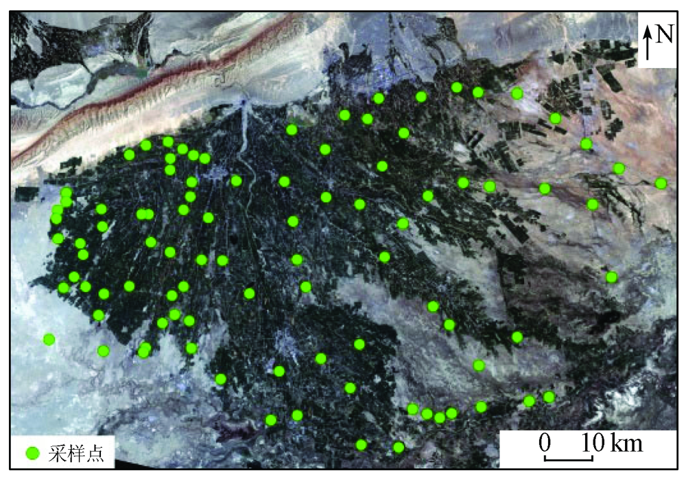
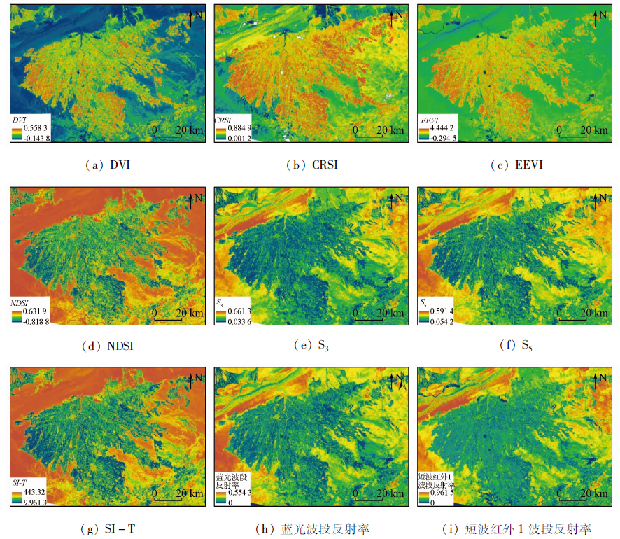
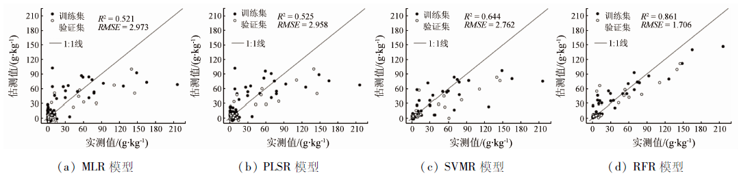
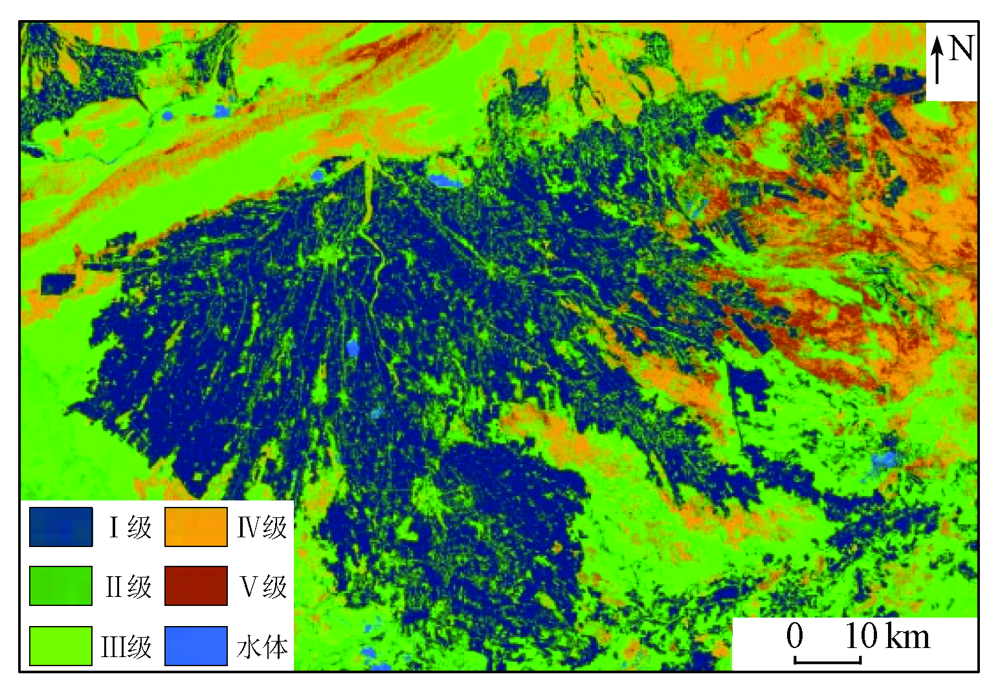
Abstract The rapid detection of soil salinity using remote sensing technology can scientifically guide the soil salinization control and the rational development of oasis agriculture. Based on 95 soil samples from the oasis of the Weigan-Kuqa River delta, this study established four soil salinity estimation models of multiple linear regression, partial least squares regression (PLSR), support vector machine regression (SVR), and random forest regression using the spectral index, band reflectance, and the measured soil salinity. Then, it conducted the remote sensing inversion for the spatial distribution pattern of the soil salinity in the study area using the optimal estimation results. The results are as follows: ① Nine spectral factors that were significantly related to soil salinity were screened using the all-subsets regression method, with correlation coefficients of all above 0.5 (P < 0.01). Among them, the correlation coefficient between salinity index SI-T and the soil salinity was the highest (0.648); ② The comparison of estimation precision show that the fitting effect of the four inversion models was in the order of random forest regression > SVR > PLSR > multiple linear regression. Among these models, the random forest model had the best fitting precision. Its training and validation sets had coefficients of determination(R2) of 0.870 and 0.766, respectively, with relative percent deviation (RPD) of 2.792 and 2.105, respectively, both of which were greater than 2. These results indicate that the random forest model had a good inversion effect and stable estimation capacity; ③ According to the inversion results of the random forest model, grade I and II zones account for 41.62% and are distributed in the cultivated land area inside the oasis; grade III, IV, and V zones account for 56.41% and are primarily distributed in the desert and the desert-oasis ecotones. Therefore, compared with conventional statistical models, the random forest modeling method can yield significantly better estimation effects in the inversion of soil salinity. This study can be used as a reference for the monitoring of soil salinization in oases in arid areas.
|
| Keywords
spectral index
machine learning model
soil salinity
remote sensing inversion
oasis in an arid area
|
|
|
|
Issue Date: 20 March 2023
|
|
|
| [1] |
Abuelgasim A, Ammad R. Mapping soil salinity in arid and semi-arid regions using Landsat8 OLI satellite data[J]. Remote Sensing Applications: Society and Environment, 2019, 13:415-425.
doi: 10.1016/j.rsase.2018.12.010
url: https://linkinghub.elsevier.com/retrieve/pii/S2352938518303069
|
| [2] |
Abdennour M A, Douaoui A, Piccini C, et al. Predictive mapping of soil electrical conductivity as a Proxy of soil salinity in south-east of Algeria[J]. Environmental and Sustainability Indicators, 2020, 8:100087.
doi: 10.1016/j.indic.2020.100087
url: https://linkinghub.elsevier.com/retrieve/pii/S2665972720300714
|
| [3] |
Eswar D, Karuppusamy R, Chellamuthu S. Drivers of soil salinity and their correlation with climate change[J]. Current Opinion in Environmental Sustainability, 2021, 50:310-318.
doi: 10.1016/j.cosust.2020.10.015
url: https://linkinghub.elsevier.com/retrieve/pii/S1877343520301032
|
| [4] |
Khadim F K, Su H, Xu L, et al. Soil salinity mapping in Everglades National Park using remote sensing techniques and vegetation salt tolerance[J]. Physics and Chemistry of the Earth, 2019, 110:31-50.
doi: 10.1016/j.pce.2019.01.004
|
| [5] |
Hammam A A, Mohamed E S. Mapping soil salinity in the East Nile Delta using several methodological approaches of salinity assessment[J]. The Egyptian Journal of Remote Sensing and Space Science, 2020, 23(2):125-131.
doi: 10.1016/j.ejrs.2018.11.002
url: https://linkinghub.elsevier.com/retrieve/pii/S1110982318301339
|
| [6] |
王遵亲, 祝寿泉, 俞仁培, 等. 中国盐渍土[M]. 北京: 科学出版社, 1993:7-78.
|
| [6] |
Wang Z Q, Zhu S Q, Yu R P, et al. Chinese saline soil[M]. Beijing: Science Press, 1993:7-78.
|
| [7] |
周磊, 贺聪聪, 吕爱锋, 等. 柴达木盆地土壤盐渍化程度快速动态监测[J]. 测绘科学, 2021, 46(7):99-106,114.
|
| [7] |
Zhou L, He C C, Lyu A F, et al. Research on quick dynamic monitoring of soil salinization in Qaidam Basin[J]. Science of Surveying and Mapping, 2021, 46(7):99-106,114.
|
| [8] |
张荣群, 乔月霞, 薛佳妮. 银川平原土壤盐渍化与土地利用强度的空间关联分析[J]. 地球信息科学学报, 2015, 17(5):598-606.
doi: 10.3724/SP.J.1047.2015.00598
|
| [8] |
Zhang R Q, Qiao Y X, Xue J N. Spatial relationship analysis between the soil salinization and land use intensity in Yinchuan Plain[J]. Journal of Geo-Information Science, 2015, 17(5):598-606.
|
| [9] |
张素铭, 赵庚星, 王卓然, 等. 滨海盐渍区土壤盐分遥感反演及动态监测[J]. 农业资源与环境学报, 2018, 35(4):349-358.
|
| [9] |
Zhang S M, Zhao G X, Wang Z R, et al. Remote sensing inversion and dynamic monitoring of soil salt in coastal saline area[J]. Journal of Agricultural Resources and Environment, 2018, 35(4):349-358.
|
| [10] |
周晓红, 张飞, 张海威, 等. 艾比湖湿地自然保护区土壤盐分多光谱遥感反演模型[J]. 光谱学与光谱分析, 2019, 39(4):1229-1235.
|
| [10] |
Zhou X H, Zhang F, Zhang H W, et al. A study of soil salinity inversion based on multispectral remote sensing index in Ebinur Lake wetland nature reserve[J]. Spectroscopy and Spectral Analysis, 2019, 39(4):1229-1235.
|
| [11] |
张同瑞, 赵庚星, 高明秀, 等. 基于近地面多光谱的黄河三角洲典型地区土壤含盐量估算研究[J]. 光谱学与光谱分析, 2016, 36(1):248-253.
|
| [11] |
Zhang T R, Zhao G X, Gao M X, et al. Soil salinity estimation based on near-ground multispectral imagery in typical area of the Yellow River Delta[J]. Spectroscopy and Spectral Analysis, 2016, 36(1):248-253.
|
| [12] |
奚雪, 赵庚星, 高鹏, 等. 基于Sentinel卫星及无人机多光谱的滨海冬小麦种植区土壤盐分反演研究——以黄三角垦利区为例[J]. 中国农业科学, 2020, 53(24):5005-5016.
doi: 10.3864/j.issn.0578-1752.2020.24.004
|
| [12] |
Xi X, Zhao G X, Gao P, et al. Inversion of soil salinity in coastal winter wheat growing area based on sentinel satellite and unmanned aerial vehicle multi-spectrum:A case study in Kenli District of the Yellow River Delta[J]. Scientia Agricultura Sinica, 2020, 53(24):5005-5016.
|
| [13] |
陈红艳, 赵庚星, 陈敬春, 等. 基于改进植被指数的黄河口区盐渍土盐分遥感反演[J]. 农业工程学报, 2015, 31(5):107-114.
|
| [13] |
Chen H Y, Zhao G X, Chen J C, et al. Remote sensing inversion of saline soil salinity based on modified vegetation index in estuary area of Yellow River[J]. Transactions of the Chinese Society of Agricultural Engineering, 2015, 31(5):107-114.
|
| [14] |
Fathizad H, Ardakani M A H, Sodaiezadeh H, et al. Investigation of the spatial and temporal variation of soil salinity using random forests in the central desert of Iran[J]. Geoderma, 2020, 365:114233.
doi: 10.1016/j.geoderma.2020.114233
url: https://linkinghub.elsevier.com/retrieve/pii/S0016706119313345
|
| [15] |
何宝忠, 丁建丽, 刘博华, 等. 渭库绿洲土壤盐渍化时空变化特征[J]. 林业科学, 2019, 55(9):185-196.
|
| [15] |
He B Z, Ding J L, Liu B H, et al. Spatiotemporal variation of soil salinization in Weigan-Kuqa River delta oasis[J]. Scientia Silvae Sinicae, 2019, 55(9):185-196.
|
| [16] |
Allbed A, Kumar L. Soil salinity mapping and monitoring in arid and semi-arid regions using remote sensing technology:A review[J]. Advances in Remote Sensing, 2013, 2:373-385.
doi: 10.4236/ars.2013.24040
url: http://www.scirp.org/journal/doi.aspx?DOI=10.4236/ars.2013.24040
|
| [17] |
Wang J Z, Ding J L, Yu D L, et al. Machine learning-based detection of soil salinity in an arid desert region,Northwest China:A comparison between Landsat8 OLI and Sentinel-2 MSI[J]. The Science of the Total Environment, 2020, 707(10):136092.
doi: 10.1016/j.scitotenv.2019.136092
url: https://linkinghub.elsevier.com/retrieve/pii/S0048969719360887
|
| [18] |
Seifi M, Ahmadi A, Neyshabouri M R, et al. Remote and Vis-NIR spectra sensing potential for soil salinization estimation in the eastern coast of Urmia hyper saline lake,Iran[J]. Remote Sensing Applications:Society and Environment, 2020, 20:100398.
doi: 10.1016/j.rsase.2020.100398
url: https://linkinghub.elsevier.com/retrieve/pii/S2352938520302366
|
| [19] |
Liu Y, Zhang F, Wang C, et al. Estimating the soil salinity over partially vegetated surfaces from multispectral remote sensing image using non-negative matrix factorization[J]. Geoderma, 2019, 354:113887.
doi: 10.1016/j.geoderma.2019.113887
url: https://linkinghub.elsevier.com/retrieve/pii/S0016706119301570
|
| [20] |
乔木, 周生斌, 卢磊, 等. 新疆渭干河流域土壤盐渍化时空变化及成因分析[J]. 地理科学进展, 2012, 31(7):904-910.
|
| [20] |
Qiao M, Zhou S B, Lu L, et al. Causes and spatial-temporal changes of soil salinization in Weigan River basin,Xinjiang[J]. Progress in Geography, 2012, 31(7):904-910.
|
| [21] |
张智韬, 杜瑜燕, 劳聪聪, 等. 基于雷达遥感的不同深度土壤含盐量反演模型[J]. 农业机械学报, 2020, 51(10):243-251.
|
| [21] |
Zhang Z T, Du Y Y, Lao C C, et al. Inversion model of soil salt content in different depths based on Radar remote sensing[J]. Transactions of the Chinese Society for Agricultural Machinery, 2020, 51(10):243-251.
|
| [22] |
苏雯, 丁建丽, 杨爱霞. 基于GF-1影像的渭-库绿洲外围土壤含盐量定量反演研究[J]. 中国农村水利水电, 2017(2):9-13.
|
| [22] |
Su W, Ding J L, Yang A X. Quantitative inversion of soil salinity in Weigan-Kuqa River oasis based on GF-1 image[J]. China Rural Water and Hydropower, 2017(2):9-13.
|
| [23] |
厉彦玲, 赵庚星, 常春艳, 等. OLI与HSI影像融合的土壤盐分反演模型[J]. 农业工程学报, 2017, 33(21):173-180.
|
| [23] |
Li Y L, Zhao G X, Chang C Y, et al. Soil salinity retrieval model based on OLI and HSI image fusion[J]. Transactions of the Chinese Society of Agricultural Engineering, 2017, 33(21):173-180.
|
| [24] |
杨练兵, 陈春波, 郑宏伟, 等. 基于优化随机森林回归模型的土壤盐渍化反演[J]. 地球信息科学学报, 2021, 23(9):1662-1674.
doi: 10.12082/dqxxkx.2021.200711
|
| [24] |
Yang L B, Chen C B, Zheng H W, et al. Retrieval of soil salinity content based on random forests regression optimized by bayesian optimization algorithm and genetic algorithm[J]. Journal of Geo-Information Science, 2021, 23(9):1662-1674.
|
| [25] |
冯娟, 丁建丽, 魏雯瑜. 基于Albedo-MSAVI特征空间的渭库绿洲土壤盐渍化研究[J]. 中国农村水利水电, 2018(2):147-152.
|
| [25] |
Feng J, Ding J L, Wei W Y. A study of soil salinization in Weigan and Kuqa Rivers oasis based on Albedo-MSAVI feature space[J]. China Rural Water and Hydropower, 2018(2):147-152.
|
|
Viewed |
|
|
|
Full text
|
|
|
|
|
Abstract
|
|
|
|
|
Cited |
|
|
|
|
| |
Shared |
|
|
|
|
| |
Discussed |
|
|
|
|
 2023,
Vol. 35
2023,
Vol. 35
 ), WANG Xuemei1,2(