|
|
 |
|

|
|
|
Remote sensing inversion of desert soil moisture based on improved spectral indices |
GAO Qi1,2( ), WANG Yuzhen1, FENG Chunhui1, MA Ziqiang3, LIU Weiyang1, PENG Jie1, JI Yanzhen2 ), WANG Yuzhen1, FENG Chunhui1, MA Ziqiang3, LIU Weiyang1, PENG Jie1, JI Yanzhen2 |
1. College of Plant Sciences, Tarim University, Alar 843300, China
2. Prefecture Geological and Environmental Monitoring Station, Changji 831100, China
3. Institute of Remote Sensing and Geographic Information System, School of Earth and Space Sciences, Peking University, Beijing 100000, China |
|
|
|
|
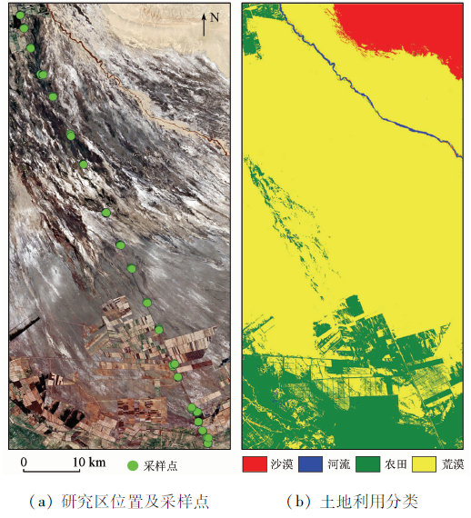
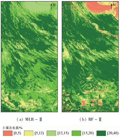
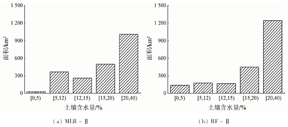
Abstract Soil moisture is an important indicator affecting dynamic climate changes, vegetation ecological recovery, and land desertification control in arid regions. Using Landsat8 OLI/TIRS multispectral remote sensing images, this study determined the optimal spectral indices by introducing thermal infrared (b10) band to improve nine traditional spectral indices and through significance tests and multiple covariance tests. Then, with the improved spectral indices as the modeling factors and based on the terrain data, this study constructed multispectral comprehensive inversion models of desert soil moisture using the multivariate linear regression (MLR) and random forest (RF) algorithms. Finally, the spatial distribution characteristics of soil moisture and their driving factors were analyzed using the optimal model. The results are as follows: ① The correlation coefficients of the improved spectral indices EBSI, ECI, ECal, ENDVI, and EPDI increased by 0.02~0.11; ② For the prediction datasets of linear and non-linear models, their R 2 increased by 0.12 and 0.05, respectively and their RPD values increased by 0.35 and 0.49, respectively after the spectral indices were improved. Moreover, the RPD value of model RF-II was up to 3.12, and thus this model can accurately predict soil moisture. ③ The accuracy of the non-linear models was significantly higher than that of the linear models. The R 2 of the prediction datasets of MLR-based linear models was only 0.59 and 0.71, while that of the RF-based non-linear models reached 0.86 and 0.91. ④ The distribution of soil moisture was influenced by both natural and artificial factors. The soil moisture content is [0, 5)% and [5, 12)% in the northeastern desert and shows cross-distribution in the southern farmland. Soil moisture is difficult to evaporate in the northern and central desert-oasis transition zones due to inhibiting factors such as the vegetation coverage and surface salt crust, with the content of [15, 20)% and [20, 40)% mostly.
|
| Keywords
improved spectral index
satellite remote sensing
soil moisture
desert soils
southern Xinjiang arid zone
|
|
|
|
Issue Date: 14 March 2022
|
|
|
| [1] |
陈亚宁, 李稚, 范煜婷, 等. 西北干旱区气候变化对水文水资源影响研究进展[J]. 地理学报, 2014, 69(9):1295-1304.
doi: 10.11821/dlxb201409005
|
| [1] |
Chen Y N, Li Z, Fan Y T, et al. Progress in research on the impact of climate change on hydrological and water resources in the northwest arid zone[J]. Acta Geographica Sinica, 2014, 69(9):1295-1304.
|
| [2] |
高露, 张圣微, 朱仲元, 等. 干旱半干旱区退化草地土壤水分变化及其对降雨时间格局的响应[J]. 水土保持学报, 2020, 34(1):195-201.
|
| [2] |
Gao L, Zhang S W, Zhu Z Y, et al. Soil moisture changes in degraded grassland and its response to rainfall temporal pattern in arid and semi-arid areas[J]. Journal of Soil and Water Conservation, 2020, 34(1):195-201.
|
| [3] |
李华朋, 张树清, 高自强, 等. MODIS植被指数监测农业干旱的适宜性评价[J]. 光谱学与光谱分析, 2013, 33(3):756-761.
|
| [3] |
Li H P, Zhang S Q, Gao Z Q, et al. Evaluating the utility of MODIS vegetation index for monitoring agricultural drought[J]. Spectroscopy and Spectral Analysis, 2013, 33(3):756-761.
|
| [4] |
Sholihah R I, Trisasongko B H, Shiddiq D, et al. Identification of agricultural drought extent based on vegetation health indices of Landsat data:Case of Subang and Karawang,Indonesia[J]. Procedia Environmental Sciences, 2016, 33:14-20.
doi: 10.1016/j.proenv.2016.03.051
url: https://linkinghub.elsevier.com/retrieve/pii/S1878029616002164
|
| [5] |
刘培君, 张琳, 艾里西尔·库尔班, 等. 卫星遥感估测土壤水分的一种方法[J]. 遥感学报, 1997, 1(2):135-138,81.
|
| [5] |
Liu P J, Zhang L, Alishir K, et al. A method for monitoring soil water contents using satellite remote sensing[J]. Journal of Remote Sensing, 1997, 1(2):135-138,81.
|
| [6] |
詹志明, 秦其明, 汪冬冬, 等. 基于NIR-Red光谱特征空间的土壤水分监测新方法[J]. 中国科学D辑:地球科学, 2006(11):1020-1026.
|
| [6] |
Zhan Z M, Qin Q M, Wang D D, et al. A new method for soil moisture monitoring based on NIR-Red spectral feature space[J]. Science in China.Series D:Earth Sciences, 2006(11):1020-1026.
|
| [7] |
李喆, 谭德宝, 秦其明, 等. 基于特征空间的遥感干旱监测方法综述[J]. 长江科学院院报, 2010, 27(1):37-41.
|
| [7] |
Li Z, Tan D B, Qin Q M, et al. Recent advance of remote sensing drought monitoring approaches based on spectral feature space[J]. Journal of Yangtze River Scientific Research Institute, 2010, 27(1):37-41.
|
| [8] |
Thenkabail P S, Enclona E A, Ashton M S, et al. Accuracy assessments of hyperspectral waveband performance for vegetation analysis applications[J]. Remote Sensing of Environment, 2004, 91(3-4):354-376.
doi: 10.1016/j.rse.2004.03.013
url: https://linkinghub.elsevier.com/retrieve/pii/S0034425704000987
|
| [9] |
Hain C R, Mecikalski J R, Anderson M C. Retrieval of an available water-based soil moisture proxy from thermal infrared remote sensing.Part I:Methodology and validation[J]. Journal of Hydrometeorology, 2009, 10(3):665-683.
doi: 10.1175/2008JHM1024.1
url: http://journals.ametsoc.org/doi/10.1175/2008JHM1024.1
|
| [10] |
葛少青, 张剑, 孙文, 等. 三种干旱指数在干旱区沼泽湿地土壤水分遥感反演中的应用[J]. 生态学报, 2018, 38(7):2299-2307.
|
| [10] |
Ge S Q, Zhang J, Sun W, et al. Application of three drought indexes in soil moisture inversion using remote sensing in marsh wetlands of arid area[J]. Acta Ecologica Sinica, 2018, 38(7):2299-2307.
|
| [11] |
蔡亮红, 丁建丽. 基于改进植被指数土壤水分遥感反演[J]. 干旱区地理, 2017, 40(6):1248-1255.
|
| [11] |
Cai L H, Ding J L. Remote sensing inversion of soil moisture based on modified vegetation index[J]. Arid Land Geography, 2017, 40(6):1248-1255.
|
| [12] |
Polykretis C, Grillakis M G, Alexakis D D. Exploring the impact of various spectral indices on land cover change detection using change vector analysis:A case study of Crete Island,Greece[J]. Remote Sensing, 2020, 12(2):319.
doi: 10.3390/rs12020319
url: https://www.mdpi.com/2072-4292/12/2/319
|
| [13] |
Hengl T. A practical guide to geostatistical mapping[M]. Amsterdam:University of Amsterdam, 2009.
|
| [14] |
Boettinger J L, Ramsey R D, Bodily J M, et al. Landsat spectral data for digital soil mapping[M]// Hartemink A E,McBratney A,Mendonca-Santos M L.Digital soil mapping with limited data.Netherlands:Springer, 2008:193-202.
|
| [15] |
Jordan C F. Derivation of leaf-area index from quality of light on the forest floor[J]. Ecology, 1969, 50(4):663-666.
doi: 10.2307/1936256
url: http://doi.wiley.com/10.2307/1936256
|
| [16] |
Rouse J W, Haas R H, Schell J A, et al. Monitoring vegetation systems in the Great Plains with ERTS[C]// The third ERTS-1 Symposium.Washington:NASA, 1973.
|
| [17] |
Tucker C J. Red and photographic infrared linear combinations for monitoring vegetation[J]. Remote Sensing of Environment, 1979, 8(2):127-150.
doi: 10.1016/0034-4257(79)90013-0
url: https://linkinghub.elsevier.com/retrieve/pii/0034425779900130
|
| [18] |
McFeeters S K. The use of the normalized difference water index (NDWI) in the delineation of open water features[J]. International Journal of Remote Sensing, 1996, 17(7):1425-1432.
doi: 10.1080/01431169608948714
url: https://www.tandfonline.com/doi/full/10.1080/01431169608948714
|
| [19] |
孙灏, 陈云浩, 孙洪泉. 典型农业干旱遥感监测指数的比较及分类体系[J]. 农业工程学报, 2012, 28(14):147-154.
|
| [19] |
Sun H, Chen Y H, Sun H Q. Comparisons and classification system of typical remote sensing indexes for agricultural drought[J]. Transactions of the Chinese Society of Agricultural Engineering, 2012, 28(14):147-154.
|
| [20] |
韩小慧. 稳健多元线性回归在地理数据处理中的应用[D]. 太原:太原理工大学, 2012.
|
| [20] |
Han X H. Application of robust multiple linear regression in geographic data processing[D]. Taiyuan:Taiyuan University of Technology, 2012.
|
| [21] |
Pal Mahesh. Random forest classifier for remote sensing classification[J]. International Journal of Remote Sensing, 2005, 26(1):217-222.
doi: 10.1080/01431160412331269698
url: https://www.tandfonline.com/doi/full/10.1080/01431160412331269698
|
| [22] |
Williams P. Implementation of near-infrared technology[M]// Williams P.Near-infrared Technology in the Agricultural and Food Industries, 2001:145-171.
|
| [23] |
高琪, 彭杰, 冯春晖, 等. 基于Landsat8数据的荒漠土壤水分遥感反演[J]. 水土保持通报, 2021, 41(1):125-131,151.
|
| [23] |
Gao Q, Peng J, Feng C H, et al. A study on inversion for remote sensing of desert soil moisture based on Landsat8 data[J]. Bulletin of Soil and Water Conservation, 2021, 41(1):125-131,151.
|
| [24] |
王佳文, 彭杰, 刘新路, 等. 基于电磁感应数据的膜下滴灌土壤水分动态变化研究[J]. 干旱区地理, 2021, 44(1):250-257.
|
| [24] |
Wang J W, Peng J, Liu X L, et al. Dynamic variation of soil moisture in field with drip irrigation under film using electromagnetic induction data[J]. Arid Land Geography, 2021, 44(1):250-257.
|
| [25] |
冷佩. 光学/热红外土壤湿度遥感反演方法研究[D]. 北京: 中国农业科学院, 2018.
|
| [25] |
Leng P. Methodology development for satellite soil moisture retrieval from optical/thermal infrared datafrom optical/thermal infrared data[D]. Beijing: Chinese Academy of Agricultural Sciences, 2018.
|
| [26] |
徐涵秋, 唐菲. 新一代Landsat系列卫星:Landsat8遥感影像新增特征及其生态环境意义[J]. 生态学报, 2013, 33(11):3249-3257.
|
| [26] |
Xu H Q, Tang F. Analysis of new characteristics of the first Landsat8 image and their ecoenvironmental significance[J]. Acta Ecologica Sinica, 2013, 33(11):3249-3257.
doi: 10.5846/stxb
url: http://www.ecologica.cn/
|
| [27] |
李宁. 三江源区地表土壤湿度的遥感反演[D]. 北京: 中国地质大学(北京),2020.
|
| [27] |
Li N. Satellite-based estimation of surface soil moisture in the Three-Rivers Headwaters Region[D]. Beijing: China University of Geosciences (Beijing),2020.
|
| [28] |
蔡亮红, 丁建丽, 魏阳. 基于多源数据的土壤水分反演及空间分异格局研究[J]. 土壤学报, 2017, 54(5):1057-1067.
|
| [28] |
Cai L H, Ding J L, Wei Y. Spatial variation and inversion of soil moisture based on multi-source data[J]. Acta Pedologica Sinica, 2017, 54(5):1057-1067.
|
| [29] |
Peng J, Biswas A, Jiang Q, et al. Estimating soil salinity from remote sensing and terrain data in southern Xinjiang Province,China[J]. Geoderma, 2019, 337:1309-1319.
doi: 10.1016/j.geoderma.2018.08.006
|
| [30] |
张建国, 徐新文, 雷加强, 等. 极端干旱区咸水滴灌林地盐结皮对土壤蒸发的影响[J]. 农业工程学报, 2010, 26(9):34-39.
|
| [30] |
Zhang J G, Xu X W, Lei J Q, et al. Effects of salt crust on soil evaporation condition with saline-waterdrip-irrigation in extreme arid region[J]. Transactions of the Chinese Society of Agricultural Engineering, 2010, 26(9):34-39.
|
| [31] |
Mendes W D, Neto L G, Dematte J A, et al. Is it possible to map subsurface soil attributes by satellite spectral transfer models[J]. Geoderma, 2019, 343:269-279.
doi: 10.1016/j.geoderma.2019.01.025
url: https://linkinghub.elsevier.com/retrieve/pii/S0016706117321006
|
| [32] |
龚新梅. 新疆土地荒漠化时空变化特征及驱动因子分析[D]. 乌鲁木齐: 新疆大学, 2007.
|
| [32] |
Gong X M. The analysis of the features of emporal-spatialvariation of desertification and its driving factors in Xinjiang[D]. Urumqi: Xinjiang University, 2007.
|
|
Viewed |
|
|
|
Full text
|
|
|
|
|
Abstract
|
|
|
|
|
Cited |
|
|
|
|
| |
Shared |
|
|
|
|
| |
Discussed |
|
|
|
|
 2022,
Vol. 34
2022,
Vol. 34