|
|
 |
|

|
|
|
A hyperspectral analysis of alteration zoning in the Hadamengou gold deposit and its significance for ore prospecting |
XU Daxing1,2( ), YANG Biao3,4(), SHAO Zhaogang1, LIU Changfeng5, WANG Da6, WANG Jianping6 ), YANG Biao3,4(), SHAO Zhaogang1, LIU Changfeng5, WANG Da6, WANG Jianping6 |
1. Chinese Academy of Geological Sciences, Beijing 100037, China
2. School of Earth and Space Sciences, Peking University,Beijing 100871, China
3. Hohhot Natural Resources Comprehensive Survey Center, Hohhot 010010, China
4. School of Earth Sciences, Chengdu University of Technology, Chengdu 610059, China
5. School of Ocean Sciences, China University of Geosciences (Beijing), Beijing 100083, China
6. School of Earth Sciences and Resources, China University of Geosciences (Beijing), Beijing 100083, China |
|
|
|
|
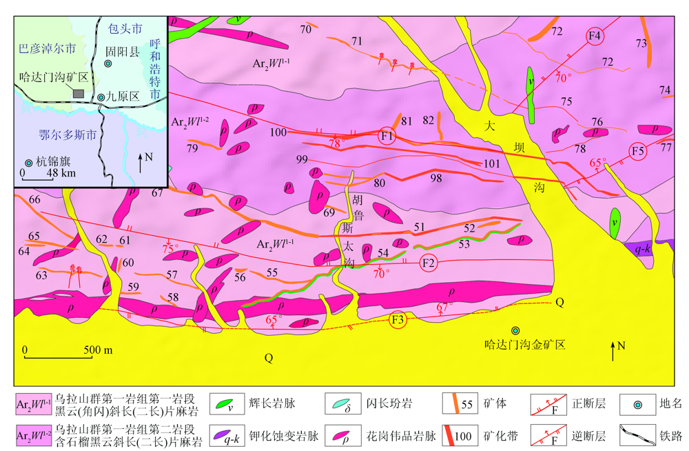
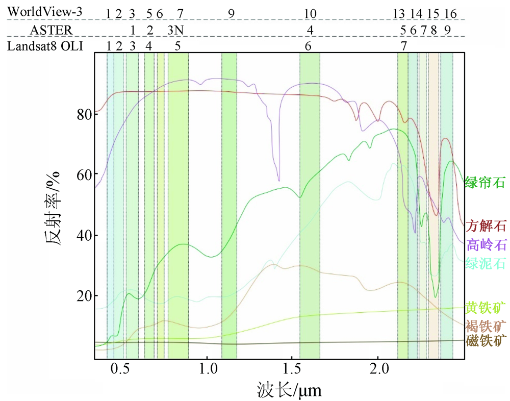
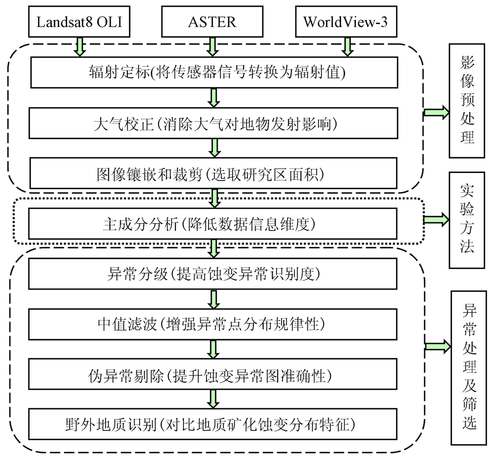
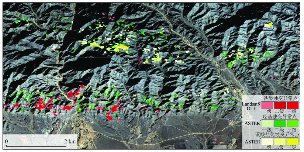
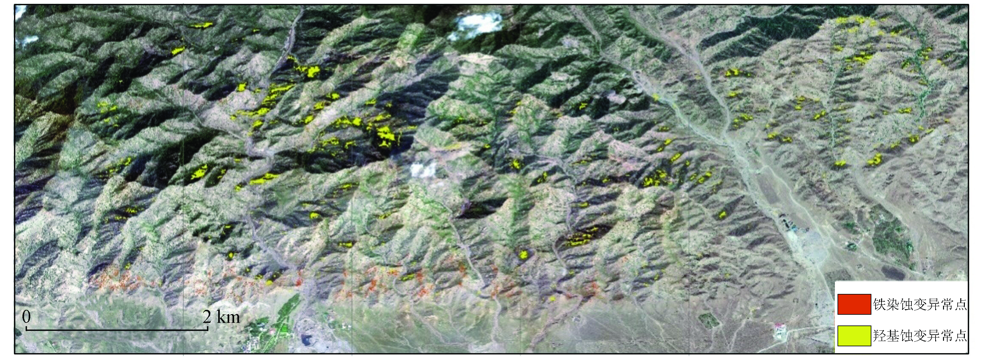
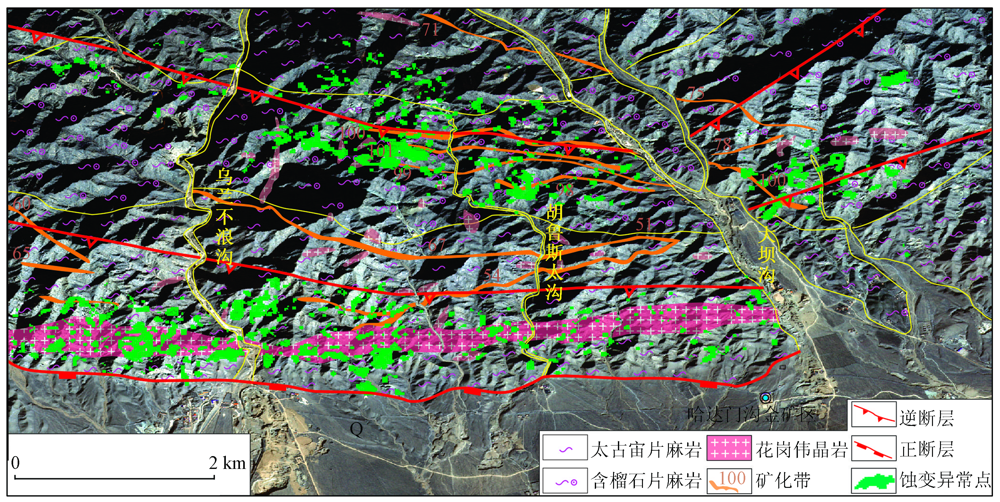
Abstract The Hadamengou gold deposit in Baotou City, Inner Mongolia is an important large gold deposit in the Wulashan-Daqingshan metallogenic belt, with great prospecting potential. To give full play to remote sensing technology in geological prospecting, this study extracted the mineralization alteration information of the Hadamengou gold deposit from remote sensing data of different satellites. Based on the spectral characteristics of alteration minerals in the mining area, this study proposed a comprehensive processing method that extracted iron staining information from the Landsat8 OLI and WorldView-3 data, hydroxyl information from the ASTER and WorldView-3 data, and carbonation information from the ASTER data through principal component analysis. As a result, two alteration zones were delineated based on the distribution patterns of alteration anomalies and the geological map analysis of the mining area. By combining the study results of the ore-controlling structures, it is believed that the metallogenic hydrothermal processes of the Hadamengou gold deposit were closely related to structures. This study can provide a reference for the prospecting for the same type of gold deposits in the Wulashan-Daqingshan metallogenic belt and can guide the peripheral prospecting of the Hadamengou gold deposit.
|
| Keywords
Hadamengou gold deposit
alteration anomaly
comprehensive processing method
ore-controlling structure
peripheral prospecting
|
|
|
|
Issue Date: 20 March 2023
|
|
|
| [1] |
张玉君, 杨建民, 陈薇. ETM+(TM)蚀变遥感异常提取方法研究与应用——地质依据和波谱前提[J]. 国土资源遥感, 2002, 54(4):31-36.doi:10.6046/gtzyyg.2002.04.07.
doi: 10.6046/gtzyyg.2002.04.07
|
| [1] |
Zhang Y J, Yang J M, Chen W. Research and application of remote sensing anomaly extraction method for ETM+(TM) alteration:Geological basis and spectral premise[J]. Remote Sensing for Land and Resources, 2002, 54(4):31-36.doi:10.6046/gtzyyg.2002.04.07.
doi: 10.6046/gtzyyg.2002.04.07
|
| [2] |
丛丽娟, 胡凤翔, 杨俊才, 等. 内蒙古朱拉扎嘎金矿ETM+数据提取蚀变异常方法研究[J]. 现代地质, 2007, 21(4):726-732.
|
| [2] |
Cong L J, Hu F X, Yang J C, et al. Study on alteration anomaly extraction method of ETM+ data in Zhulazaga gold deposit,Inner Mongolia[J]. Geoscience, 2007, 21 (4):726-732.
|
| [3] |
张玉君, 杨建民, 姚佛军. 多光谱遥感技术预测矿产资源的潜能——以蒙古国欧玉陶勒盖铜金矿床为例[J]. 地学前缘, 2007, 14(5):64-70.
|
| [3] |
Zhang Y J, Yang J M, Yao F J. Prediction of mineral resources potential using multi-spectral remote sensing technology:A case study of Ouyutolgoi Cu-Au deposit in Mongolia[J]. Earth Science Frontiers, 2007, 14(5):64-70.
doi: 10.1016/S1872-5791(07)60003-7
url: https://linkinghub.elsevier.com/retrieve/pii/S1872579107600037
|
| [4] |
刘建宇, 陈玲, 李伟, 等. 基于ASTER数据韧性剪切带型金矿蚀变信息提取方法优化[J]. 国土资源遥感, 2019, 31(1):229-236.doi:10.6046/gtzyyg.2019.01.30.
doi: 10.6046/gtzyyg.2019.01.30
|
| [4] |
Liu J Y, Chen L, Li W, et al. Optimization of alteration information extraction method for ductile shear zone type gold deposit based on ASTER data[J]. Remote Sensing for Land and Resources, 2019, 31(1):229-236.doi:10.6046/gtzyyg.2019.01.30.
doi: 10.6046/gtzyyg.2019.01.30
|
| [5] |
Xu K, Wang X F, Kong C F, et al. Identification of hydrothermal alteration mineralsfor exploring gold deposits based on SVM and PCA using ASTER data:A case study of Gulong[J]. Remoting Sensing, 2019, 11(12):1-22.
|
| [6] |
Salehi T, Tangestani M H. Large-scale mapping of iron oxide and hydroxide minerals of Zefreh porphyry copper deposit,using Worldview-3 VNIR data in the Northeastern Isfahan,Iran[J]. International Journal of Applied Earth Observation and Geoinformation, 2018, 73(6):156-169.
doi: 10.1016/j.jag.2018.06.010
url: https://linkinghub.elsevier.com/retrieve/pii/S0303243418302022
|
| [7] |
Sun Y Q, Tian S F, Di B G. Extracting mineral alteration information using WorldView-3 data[J]. Geoscience Frontiers, 2017, 8(5):1051-1062.
doi: 10.1016/j.gsf.2016.10.008
url: https://linkinghub.elsevier.com/retrieve/pii/S1674987116301554
|
| [8] |
毛晓长, 刘文灿, 杜建国, 等. ETM+和ASTER数据在遥感矿化蚀变信息提取应用中的比较——以安徽铜陵凤凰山矿田为例[J]. 现代地质, 2005(2):309-314.
|
| [8] |
Mao X C, Liu W C, Du J G, et al. Comparison of ETM+ and ASTER data in remote sensing alteration information extraction:A case study of the Fenghuangshan ore field in Tongling,Anhui Province[J]. Geoscience, 2005(2):309-314.
|
| [9] |
Zhang T B, Yi G H, Li H M, et al. Integrating data of ASTER and Landsat-8 OLI (AO) for hydrothermal alteration mineral mapping in Duolong porphyry Cu-Au deposit,Tibetan Plateau,China[J]. Remote Sensing, 2016, 8(11):1-23.
doi: 10.3390/rs8010001
url: http://www.mdpi.com/2072-4292/8/1/1
|
| [10] |
Bedini E. Application of WorldView-3 imagery and ASTER TIR data to map alteration minerals associated with the Rodalquilar gold deposits,southeast Spain[J]. Advances in Space Research, 2019, 63(10):336-3357.
|
| [11] |
Zhang, Y P, Chen, X H, Zuza A V, et al. Sedimentary paleoenvironment of the eastern Hexi Corridor,NW China:Constraints from chert geochemistry and sedimentary analysis of early paleozoic strata[J]. Acta Geologica Sinica, 2020, 94(4):1223-1237.
|
| [12] |
Wang Y,Chen, X H, Nie L S, et al. Late paleozoic element migration and accumulation under intracontinental sinistral strike-slip faulting in the west junggar orogenic belt,NW China[J]. Acta Geologica Sinica, 2020, 94(6):2012-2030.
|
| [13] |
张义平, 肖文霞, 张进, 等. 河西走廊东部香山群时代和物源讨论[J]. 中国地质, 2015, 42(6):1774-1792.
|
| [13] |
Zhang Y P, Xiao W X, Zhang J, et al. The age and provenance of Xiangshan Group in the east of Hexi Corridor[J]. Geology of China, 2015, 42(6):1774-1792.
|
| [14] |
Zhang Y M, Gu X X, Xiang Z L, et al. Magmatic hydrothermal origin of the Hadamengou-Liubagou Au-Mo deposit,Inner Mongolia,China:Constrians on geology,stable and Re-Os isotopes[J]. Ore Geology Reviews, 2017(2), 86:172-195.
doi: 10.1016/j.oregeorev.2017.01.029
url: https://linkinghub.elsevier.com/retrieve/pii/S0169136816305224
|
| [15] |
徐大兴. 内蒙古哈达门沟金矿床构造控矿研究及意义[D]. 北京: 中国地质大学(北京), 2021.
|
| [15] |
Xu D X. Study on ore-controlling structure of the Hadamengou deposit in Inner Mongolia and its significance[D]. Beijing: China University of Geosciences (Beijing), 2021.
|
| [16] |
苏胜贵. 内蒙古哈达门沟金矿田100号脉深部找矿预测[D]. 北京: 中国地质大学(北京), 2019.
|
| [16] |
Su S G. Deep prospecting prediction of No.100 vein in the Hadamenggou gold field,Inner Mongolia[D]. Beijing: China University of Geosciences (Beijing), 2019.
|
| [17] |
章永梅. 内蒙古柳坝沟—哈达门沟金矿田成因、控矿因素与找矿方向[D]. 北京: 中国地质大学(北京), 2012.
|
| [17] |
Zhang Y M. Genesis,ore-controlling factors and prospecting direction of Liubagou-Hadamengou gold deposit in Inner Mongolia[D]. Beijing: China University of Geosciences (Beijing), 2012.
|
| [18] |
侯万荣. 内蒙古哈达门沟金矿床与金厂沟梁金矿床对比研究[D]. 北京: 中国地质科学院, 2011.
|
| [18] |
Hou W R. Comparative study on the Hadamenggou gold deposit and Jinchanggouliang gold deposit in Inner Mongolia[D]. Beijing: Chinese Academy of Geological Sciences, 2011.
|
| [19] |
张玉君, 曾朝铭. 西藏冈底斯地区斑岩铜矿识别的最佳多光谱遥感异常判别研究[J]. 矿床地质, 2012, 31(4):671-698.
|
| [19] |
Zhang Y J, Zeng C M. Study on the best multi-spectral remote sensing anomaly identification of porphyry copper deposits in Gangdisi area,Tibet[J]. Mineral Deposits, 2012, 31(4):671-698.
|
| [20] |
白雅文. 遥感技术在地质构造信息提取中的应用——以内蒙古四子王旗地区为例[D]. 北京: 中国地质大学(北京), 2006.
|
| [20] |
Bai Y W. Application of remote sensing technology in geological structure information extraction:A case study of Siziwang Banner,Inner Mongolia[D]. Beijing: China University of Geosciences (Beijing), 2006.
|
| [21] |
Karimzadeh S, Tangestani M H. Evaluating the VNIR-SWIR datasets of WorldView-3 forlithological mapping of a metamorphic-igneous terrain usingsupport vector machine algorithm:A case study of central Iran[J]. Advances in Space Research, 2021, 68(6):2421-2440.
doi: 10.1016/j.asr.2021.05.002
url: https://linkinghub.elsevier.com/retrieve/pii/S0273117721003719
|
| [22] |
郑亚东, Davis G A, 王琮, 等. 内蒙古大青山大型逆冲推覆构造[J]. 中国科学(D 辑), 1998, 28(4):289-295.
|
| [22] |
Zheng Y D, Davis G A, Wang C, et al. Large thrust nappe structure in Daqingshan,Inner Mongolia[J]. Science in China(Series D), 1998, 28(4):289-295.
|
| [23] |
张进江, 戚国伟, 郭磊, 等. 内蒙古大青山逆冲推覆体系中生代逆冲构造活动的40Ar-39Ar定年[J]. 岩石学报, 2009,(3):609-620.
|
| [23] |
Zhang J J, Qi G W, Guo L, et al. 40Ar-39Ar dating of Mesozoic thrust activity in Daqingshan thrust nappe system,Inner Mongolia[J]. Journal of Rock, 2009,(3):609-620.
|
| [24] |
刘正宏, 徐仲元, 杨振升. 大青山逆冲推覆体系含义及地质特征[J]. 世界地质, 2001, 20(3):224-230.
|
| [24] |
Liu Z H, Xu Z Y, Yang Z S. Implications and geological characteristics of Daqingshan thrust nappe system[J]. World Geology, 2001, 20(3):224-230.
|
| [25] |
王建平, 杨玉东. 内蒙大青山地区的冲断和推覆构造[R]. 北京: 中国地质科学院地质力学研究所, 1983:44-57.
|
| [25] |
Wang J P, Yang Y D. Thrust and nappe structures in Daqingshan area,Inner Mongolia[R]. Beijing: Institute of Geomechanics Chinese Academy of Geological Sciences, 1983:44-57.
|
| [26] |
王海滨, 张进江, 古大祥, 等. 内蒙古中部盘羊山逆冲推覆体系的构造特征、活动时限与构造意义[J]. 大地构造与成矿学, 2021, 45(5):839-850.
|
| [26] |
Wang H B, Zhang J J, Gu D X, et al. Tectonic characteristics,active time and tectonic significance of Panyangshan thrust nappe system in central Inner Mongolia[J]. Tectonics and Metallogeny, 2021, 45(5):839-850.
|
| [27] |
杜菊民, 张庆龙, 李洪喜, 等. 内蒙古中部大青山地区推覆构造系统及与断层相关的褶皱[J]. 地质通报, 2005, 24(7):660-664.
|
| [27] |
Du J M, Zhang Q L, Li H X, et al. Nappe structural system and fault-related folds in Daqingshan area,central Inner Mongolia[J]. Geological Bulletin of China, 2005, 24 (7):660-664.
|
| [28] |
张浩然. 内蒙古大青山东段逆冲推覆构造[D]. 北京: 中国地质大学(北京), 2009.
|
| [28] |
Zhang H R. Thrust nappe structure in eastern Daqingshan section,Inner Mongolia[D]. Beijing: China University of Geosciences (Beijing), 2009.
|
| [29] |
何斌. 内蒙古大青山西段晚古生代—中生代逆冲系统及其演化[D]. 北京: 中国地质大学(北京), 2019.
|
| [29] |
He B. Late Paleozoic to Mesozoic thrust system and its evolution in western Daqingshan section,Inner Mongolia[D]. Beijing: China University of Geosciences (Beijing), 2019.
|
| [30] |
刘得文. 内蒙古哈达门沟金矿区构造变形特征与控矿构造研究[D]. 北京: 中国地质大学(北京), 2014.
|
| [30] |
Liu D W. Study on structural deformation characteristics and ore-controlling structure of the Hadamenggou gold deposit,Inner Mongolia[D]. Beijing: China University of Geosciences (Beijing), 2014.
|
| [31] |
Yan S X, Liu Q S, Wang H M, et al. Remote sensing strategic exploration of large or superlarge gold ore deposits[C]// Asia-Pacific Symposium on Remote Sensing of the Atmosphere,Environment,and Space, 1998.
|
|
Viewed |
|
|
|
Full text
|
|
|
|
|
Abstract
|
|
|
|
|
Cited |
|
|
|
|
| |
Shared |
|
|
|
|
| |
Discussed |
|
|
|
|
 2023,
Vol. 35
2023,
Vol. 35