|
|
|
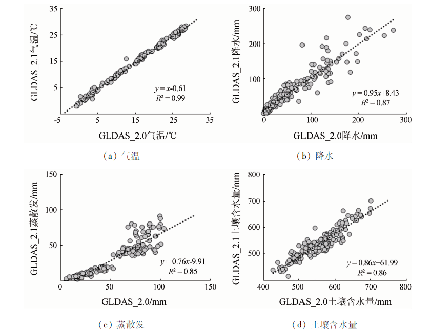
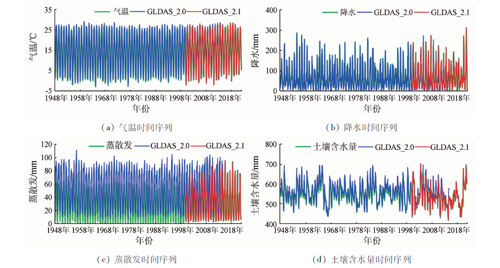
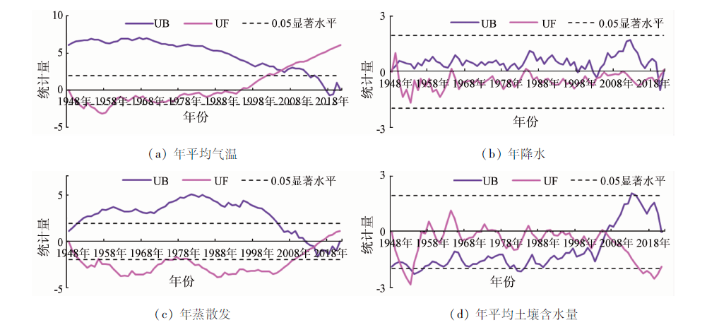
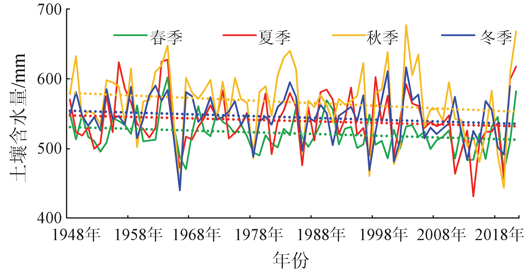
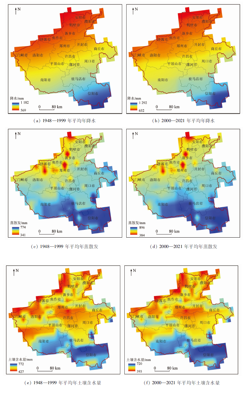
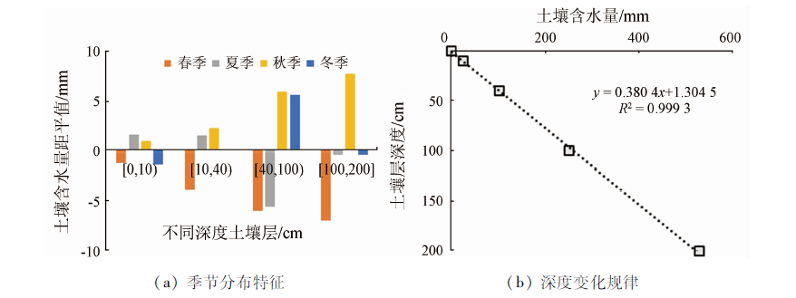
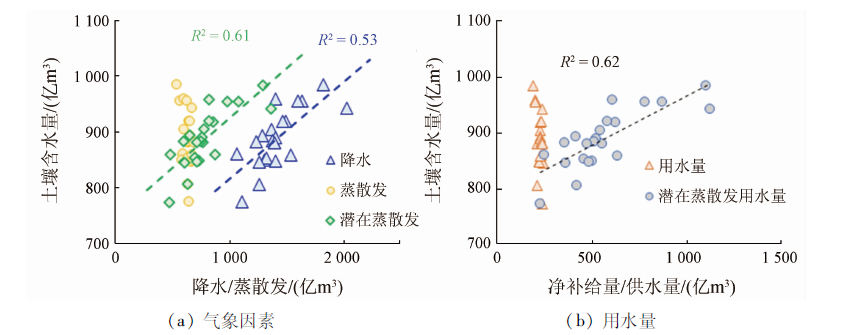
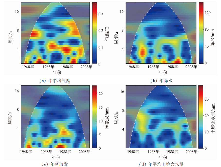
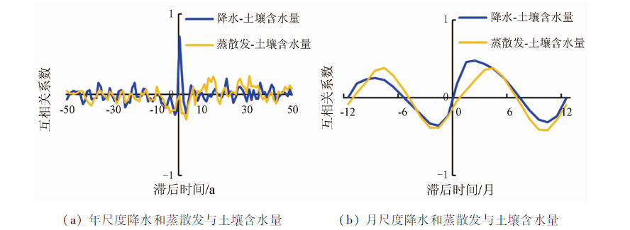
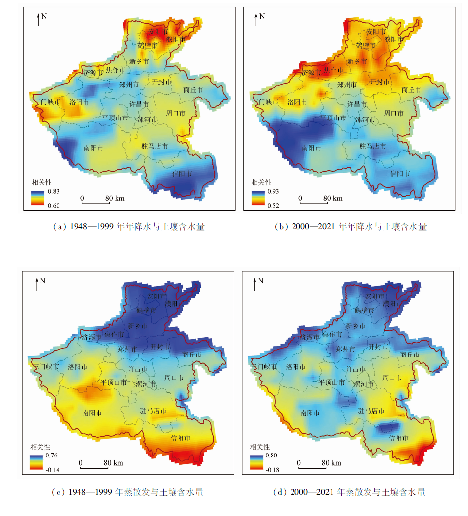
Abstract This study constructed a monthly soil moisture content dataset of Henan Province during 1948—2021 by combining 1948—2014 GLDAS_2.0 data and 2000—2021 GLDAS_2.1 data. Through the Mann-Kendall (M-K) trend analysis, mutation test, wavelet analysis, and cross-correlation analysis, this study revealed the spatio-temporal distribution and critical influencing factors of soil moisture content in Henan Province. The results show that compared with the monthly soil moisture content data provided by GLDAS_2.1, the reconstructed monthly soil moisture content data during 2000—2014 showed an average deviation, average absolute error, and root mean square error of 2.09 mm, 13.01 mm, and 18.26 mm, respectively, indicating reliable data. According to the constructed soil moisture content data, the soil moisture content decreased at a rate of 0.301 0 mm/a during 1948—2021, with change rates of -0.236 8 mm/a in spring, -0.085 5 mm/a in summer, -0.380 5 mm/a in autumn, and -0.240 3 mm/a in winter in Henan Province. Spatially, the soil moisture content decreased from south to north, highly consistent with precipitation and evapotranspiration. The soil moisture content was 2.63 mm/cm in the vertical direction. The wavelet and cross-correlation analyses show that precipitation is a critical factor influencing soil moisture content. This study revealed the long-time-series spatio-temporal distribution of soil moisture content in Henan Province, providing a basis for the scientific management of surface water resources in Henan Province.
|
| Keywords
GLDAS
soil moisture content
M-K trend analysis
wavelet analysis
cross-correlation analysis
Henan Province
|
|
|
|
Issue Date: 19 September 2023
|
|
|
| [1] |
雷志鹏, 胡和平, 杨诗秀. 土壤水研究进展与评述[J]. 水科学进展, 1999, 10(3):311-318.
|
| [1] |
Lei Z P, Hu H P, Yang S X. A review of soil water research[J]. Advances in Water Science, 1999, 10(3):311-318.
|
| [2] |
Seneviratne S I, Corti T, Davin E L, et al. Investigating soil moisture-climate interactions in a changing climate:A review[J]. Earth-Science Reviews, 2010, 99(3-4):125-161.
doi: 10.1016/j.earscirev.2010.02.004
url: https://linkinghub.elsevier.com/retrieve/pii/S0012825210000139
|
| [3] |
解文艳, 樊贵盛. 土壤含水量对土壤入渗能力的影响[J]. 太原理工大学学报, 2004, 35(3):272-275.
|
| [3] |
Xie W Y, Fan G S. Influence of moisture content on infiltration characteristics in field soils[J]. Journal of Taiyuan University of Technology, 2004, 35(3):272-275.
|
| [4] |
张学礼, 胡振琪, 初士立. 土壤含水量测定方法研究进展[J]. 土壤通报, 2005, 36(1):118-123.
|
| [4] |
Zhang X L, Hu Z Q, Chu S L. Methods for measuring soil water content:A review[J]. Chinese Journal of Soil Science, 2005, 36(1):118-123.
|
| [5] |
朱国锋, 蒲焘, 何元庆, 等. 横断山区土壤相对湿度时空分异[J]. 地理科学, 2012, 32(7):872-877.
doi: 10.13249/j.cnki.sgs.2012.07.872
|
| [5] |
Zhu G F, Pu T, He Y Q, et al. Spatial and temporal variation of soil relative moisture in Hengduan mountainous region,China[J]. Scientia Geographica Sinica, 2012, 32(7):872-877.
|
| [6] |
赵立军. 基于MODIS数据的北京地区土壤含水量遥感信息模型研究[D]. 北京: 中国农业大学, 2014.
|
| [6] |
Zhao L J. Study on remote sensing information model of soil water content in Beijing based on MODIS data[D]. Beijing: China Agricultural University, 2014.
|
| [7] |
Sonia I S, Thierry C, Edouard L, et al. Investigating soil moisture-climate interactions in a changing climate:A review[J]. Earth-Science Reviews, 2010, 99(3-4):121-161.
|
| [8] |
Nazmus S, Iliana M, John B. Leveraging Google Earth Engine for drought assessment using global soil moisture data[J]. Remoting Sensing, 2018, 10(8):1265.
|
| [9] |
Jostein B, Paul D H, Philipp S, et al. Monitoring soil moisture drought over northern high latitudes from space[J]. Remote Sensing, 2019, 11(10):1200.
doi: 10.3390/rs11101200
url: https://www.mdpi.com/2072-4292/11/10/1200
|
| [10] |
Rodell M, Houser P R, Jambor U, et al. The global land data assimilation system[J]. Bulletin of the American Meteorological Society, 2004, 85(3):381-394.
doi: 10.1175/BAMS-85-3-381
url: https://journals.ametsoc.org/doi/10.1175/BAMS-85-3-381
|
| [11] |
刘任莉, 佘敦先, 李敏, 等. 利用卫星观测数据评估GLDAS与WGHM水文模型的适用性[J]. 武汉大学学报(信息科学版), 2019, 44(11):1596-1604.
|
| [11] |
Liu R L, She D X, Li M, et al. Using satellite observations to assess applicability of GLDAS and WGHM hydrological model[J]. Geomatics and Information Science of Wuhan Unibersity, 2019, 44(11):1596-1604.
|
| [12] |
钱安, 易爽, 孙广通, 等. GLDAS_NOAH_M.2.1水文模型在青藏高原的适定性分析[J]. 大地测量与地球动力学, 2018, 38(3):254-259.
|
| [12] |
Qian A, Yi S, Sun G T, et al. GLDAS_NOAH_M.2.1 hydrological model and its application analysis in Qinghai-Tibet Plateau[J]. Journal of Geodesy and Geoodynamics, 2018, 38(3):254-259.
|
| [13] |
王文, 崔巍, 王鹏. GLDAS Noah模型水文产品与中国地面观测及卫星观测数据的对比[J]. 水电能源科学, 2017, 35(5):1-6.
|
| [13] |
Wang W, Cui W, Wang P. Comparison of GLDAS NOAH model hydrological outputs with ground observations and satellite observations in China[J]. Water Resources and Power, 2017, 35(5):1-6.
|
| [14] |
王晨阳, 马元喜. 不同土壤水分条件下小麦根系生态生理效应的研究[J]. 华北农学报, 1992, 7(4):1-8.
doi: 10.3321/j.issn:1000-7091.1992.04.001
|
| [14] |
Wang C Y, Ma Y X. Ecological and physiological effects on root systems of wheat under different soil water conditions[J]. Acta Agcultureal Boreali-Sinica, 1992, 7(4):1-8.
|
| [15] |
王洁, 边宇晗, 陈裕迪, 等. 基于GRACE陆地水储量估算土壤湿度变化: 以中国东部季风区为例[J]. 南水北调与水利科技, 2021, 19(3):459-468.
|
| [15] |
Wang J, Bian Y H, Chen Y D, et al. Estimation of soil moisture changes based on GRACE terrestrial water storage:Taking the monsoon region in eastern China as an example[J]. South to North Water Transfers and Water Science and Technology, 2021, 19(3):459-468.
|
| [16] |
汪小菊, 王文, 王鹏. GLDAS月气温数据在中国区的适用性评估[J]. 水电能源科学, 2014, 32(11):10-13.
|
| [16] |
Wang X J, Wang W, Wang P. Assessing applicability of GLDAS monthly temperature data in China[J]. Water Resources and Power, 2014, 32(11):10-13.
|
| [17] |
许顺芳, 王林松, 陈超, 等. 利用GRACE及气象数据评估GLDAS 水文模型在青藏高原的适用性[J]. 大地测量与地球动力学, 2018, 38(1):8-13.
|
| [17] |
Xu S F, Wang L S, Chen C, et al. Using GRACE and in-situ measurements to assess the applicability of GLDAS hydrological model in Tibet Plateau[J]. Journal of Geodesy and Geodynamics, 2018, 38(1):8-13.
|
| [18] |
程善俊, 管晓丹, 黄建平, 等. 利用GLDAS资料分析黄土高原半干旱区土壤湿度对气候变化的响应[J]. 干旱气象, 2013, 31(4) :641-649.
doi: 10. 11755/j. issn. 1006 -7639(2013) -04 -0641
|
| [18] |
Cheng S J, Guan X D, Huang J P, et al. Analysis of response of soil moisture to climate change in semi-arid Loess Plateau in China based on GLDAS data[J] Journal of Arid Meteorology, 2013, 31(4):641-649.
|
| [19] |
沈润平, 张悦, 师春香, 等. 长时间序列多源土壤湿度产品在中国地区的比较分析[J]. 气象科学, 2016, 44(6):867-874.
|
| [19] |
Shen R P, Zhang Y, Shi C X, et al. Inter-comparison of various long-time soil moisture datasets in China[J]. Meteorological Science and Technology, 2016, 44(6):867-874.
|
| [20] |
张述文, 刘源, 曹帮军, 等. GLDAS和CMIP5产品的中国土壤湿度—降水耦合分析及变化趋势[J]. 气候与环境研究, 2016, 21(2):188-196.
|
| [20] |
Zhang S W, Liu Y, Cao B J, et al. Soil moisture-precipitation coupling and trends in China,based on GLDAS and CMIP5 products[J] Climatic and Environmental Research, 2016, 21(2):188-196.
|
| [21] |
吴盼, 冯雨晴, 梁四海, 等. 基于GLDAS与TVDI降尺度反演土壤含水量[J]. 北京师范大学学报(自然科学版), 2016, 52(3):265-270.
|
| [21] |
Wu P, Feng Y Q, Liang S H, et al. Soil moisture-precipitation coupling and trends in China based on GLDAS and CMIP5 products[J]. Journal of Beijing Normal University (Natural Science), 2016, 52(3):265-270.
|
| [22] |
孙茂军, 李霞, 李小刚, 等. 基于MODIS与GLDAS数据的湟水河流域土壤水反演[J]. 世界地质, 2019, 38(1):286-292.
|
| [22] |
Sun M J, Li X, Li X G, et al. Soil water inversion in Huangshui River basin based on MODIS and GLDAS data[J]. Global Geology, 2019, 38(1):286-292.
|
| [23] |
刘佩佩, 宋海清, 鲍炜炜, 等. CLDAS和GLDAS土壤温度数据在陕西省的适用性评估[J]. 气象科技, 2021, 49(4):604-611.
|
| [23] |
Liu P P, Song H Q, Bao W W, et al. Applicability evaluation of CLDAS and GLDAS soil temperature data in Shaanxi Province[J]. Meteorological Science and Technology, 2021, 49(4):604-611.
|
| [24] |
艾宁, 强大宏, 刘长海, 等. 半干旱黄土区山地枣林春季土壤水分动态变化研究[J]. 农业现代化研究, 2019, 40(2):342-348.
|
| [24] |
Ai N, Qiang D H, Liu C H, et al. Dynamics of spring soil moisture in jujube forest in the semi-arid hilly area of Loess Plateau[J]. Research of Agricultural Modernization, 2019, 40(2):342-348.
|
| [25] |
何其华, 何永华, 包维楷. 干旱半干旱区山地土壤水分动态变化[J]. 山地学报, 2003, 21(2):149-156.
|
| [25] |
He Q H, He Y H, Bao W K. Research on dynamics of soil moisture in arid and semiarid mountainous areas[J]. Journal of Mountain Science, 2003, 21(2):149-156.
|
| [26] |
米热古力·艾尼瓦尔, 海米提·依米提, 麦麦提吐尔逊·艾则孜, 等. 基于小波分析的伊塞克湖水位变化特征[J]. 水土保持研究, 2014, 21(1):168-172.
|
| [26] |
Mihrigul A, Hamid Y, Mamattursum E, et al. Water level variations of Issyk-kul Lake based on wavelet analysis[J]. Research of Soil and Water Conservation, 2014, 21(1):168-172.
|
| [27] |
祁晓凡, 杨丽芝, 晔韩, 等. 济南泉域地下水位动态及其对降雨响应的交叉小波分析[J]. 地球科学进展, 2012, 27(9):969-978.
doi: 10.11867/j.issn.1001-8166.2012.09.0969
|
| [27] |
Qi X F, Yang L Z, Ye H, et al. Cross wavelet analysis of groundwater level regimes and precipitation-groundwater level regime in Ji’nan Spring Region[J]. Advances in Earth Science, 2012, 27(9):969-978.
|
| [28] |
邵晓梅, 许月卿, 严昌荣. 黄河流域降水序列变化的小波分析[J]. 北京大学学报(自然科学版), 2006, 42(4):503-509.
|
| [28] |
Shao X M, Xu Y Q, Yan C R. Wavelet analysis of rainfall variation in the Yellow River basin[J]. Journal of Peking University (Natural Science), 2006, 42(4):503-509.
|
| [29] |
张建云, 章四龙, 王金星, 等. 近50年来中国六大流域年际径流变化趋势研究[J]. 水科学进展, 2007, 18(2):230-234.
|
| [29] |
Zhang J Y, Zhang S L, Wang J X, et al. Study on runoff trends of the six larger basins in China over the past 50 years[J]. Advances in Water Science, 2007, 18(2):230-234.
|
| [30] |
Guo Y, Wang F, Qin D J, et al. Hydrodynamic characteristics of a typical Karst spring system based on time series analysis in northern China[J]. China Geology, 2021, 4(3):434-448.
doi: 10.31035/cg2021049
url: http://chinageology.cgs.cn/article/doi/10.31035/cg2021049?pageType=en
|
| [31] |
Bouchaoua L, Manginb A, Chauve P. Turbidity mechanism of water from a karstic spring example of the Ain Asserdoune spring (Beni Mellal Atlas,Morocco)[J]. Journal of Hydrology, 2002, 265(1):34-42.
doi: 10.1016/S0022-1694(02)00098-7
url: https://linkinghub.elsevier.com/retrieve/pii/S0022169402000987
|
| [32] |
Fiorillo F, Doglioni A. The relation between Karst spring discharge and rainfall by cross-correlation analysis (Campania,southern Italy)[J]. Hydrogeology Journal, 2010, 18(8):1881-1895.
doi: 10.1007/s10040-010-0666-1
url: http://link.springer.com/10.1007/s10040-010-0666-1
|
| [33] |
李建鸿, 蒲俊兵, 张陶, 等. 相关和频谱分析法在岩溶系统中的应用研究综述[J]. 中国岩溶, 2020, 39(3):335-344.
|
| [33] |
Li J H, Pu J B, Zhang T, et al. Application of correlation and spectrum analysis in Karst system research[J]. Carsologica Sinica, 2020, 39(3):335-344.
|
|
Viewed |
|
|
|
Full text
|
|
|
|
|
Abstract
|
|
|
|
|
Cited |
|
|
|
|
| |
Shared |
|
|
|
|
| |
Discussed |
|
|
|
|
 2023,
Vol. 35
2023,
Vol. 35
 ), GAN Fuping, YAN Bokun, BAI Juan, XING Naichen, LIU Qi