|
|
 |
|

|
|
|
Evaluation of typical natural landscapes in Xinjiang based on an EWM-CRITIC-TOPSIS model |
WANG Fanglei1,2,3( ), ZHANG Lei1,2(), ZHAI Fuxiang4 ), ZHANG Lei1,2(), ZHAI Fuxiang4 |
1. Key Laboratory of Digital Earth Science, Aerospace Information Research Institute, Chinese Academy of Sciences, Beijing 100094, China
2. International Research Center of Big Data for Sustainable Development Goals, Beijing 100094, China
3. University of Chinese Academy of Sciences, Beijing 100049, China
4. Aerospace Times Feihong Technology Company Limited, Beijing 100094, China |
|
|
|
|
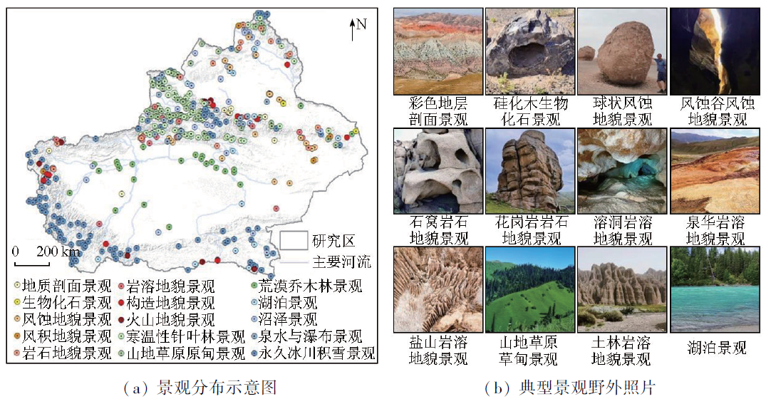
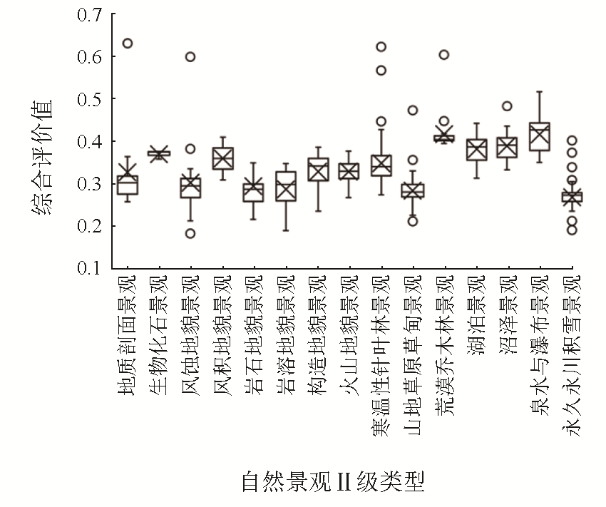
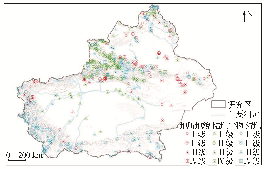
Abstract In 2021, China launched the third comprehensive scientific expedition in Xinjiang to establish a natural protected area system centered around national parks and to achieve the goal of the declaration and protection of world natural heritage. Based on the natural landscape identification using the space-ground integrated technology, this study constructed an EWM-CRITIC-TOPSIS model, followed by the elevation of 460 typical natural landscapes of 15 categories in Xinjiang. The results indicate that compared to traditional multi-index evaluation methods, the EWM-CRITIC-TOPSIS model can reduce the limitations of a single weighting approach by comprehensively considering various evaluation indicators, proving highly applicable to landscape assessment. The assessment of landscapes by categories reveals that grade I, II, III, and IV geological and geomorphological landscapes account for 2.9%, 30.5%, 44.7%, and 21.9%, respectively; grade I, II, III, and IV terrestrial biological landscape represent 1.7%, 24.6%, 40.0%, and 33.7%, respectively, and grade I, II, III, and IV wetland landscapes account for 12.2%, 26.7%, 52.2%, and 8.9%, respectively. This study will provide an important foundation and reference for the protection, utilization, and management of natural landscape resources in Xinjiang.
|
| Keywords
typical natural landscape investigation
landscape evaluation
entropy weight method (EWM)
CRITIC weight method
technique for order preference by similarity to ideal solution (TOPSIS)
|
|
|
|
Issue Date: 17 February 2025
|
|
|
| [1] |
成程, 肖燚, 饶恩明. 北京香山公园自然景观价值二十年变迁[J]. 生态学报, 2014, 34(20):6020-6027.
|
| [1] |
Cheng C, Xiao Y, Rao E M. Analysis of natural landscape value change in recent 20 years of Xiangshan Park in Beijing[J]. Acta Ecologica Sinica, 2014, 34(20):6020-6027.
|
| [2] |
肖笃宁, 李秀珍. 当代景观生态学的进展和展望[J]. 地理科学, 1997, 17(4):356-364.
|
| [2] |
Xiao D N, Li X Z. Development and prospect of contemperary landscape ecology[J]. Scientia Geographica Sinica, 1997, 17(4):356-364.
|
| [3] |
王春玲, 樊怡琳, 庞勇, 等. 基于GEE与Sentinel-2影像的落叶针叶林提取[J]. 北京林业大学学报, 2023, 45(8):1-15.
|
| [3] |
Wang C L, Fan Y L, Pang Y, et al. Extraction of deciduous conife-rous forest based on Google Earth Engine(GEE) and Sentinel-2 image[J].Journal of Beijing Forestry University, 2023, 45(8):1-15.
|
| [4] |
王磊, 方维萱, 鲁佳, 等. 新疆乌恰康苏地区构造地貌与景观生态格局研究[J]. 地质力学学报, 2022, 28(1):101-112.
|
| [4] |
Wang L, Fang W X, Lu J, et al. A study on tectonic geomorphology and landscape ecological pattern in the Kangsu area,Wuqia,Xinjiang[J]. Journal of Geomechanics, 2022, 28(1):101-112.
|
| [5] |
Dong S, Ma J, Mo Y, et al. GIS-based watershed unit forest landscape visual quality assessment in Yangshuo section of Lijiang River basin,China[J]. Sustainability, 2022, 14(22):14895.
|
| [6] |
张致义. 冬奥平原快速通道林带视觉景观质量评价研究[D]. 北京: 中国林业科学研究院, 2021.
|
| [6] |
Zhang Z Y. Study on visual landscape quality evaluation of fast track forest belt in winter Olympic plain[D]. Beijing: Chinese Academy of Forestry, 2021.
|
| [7] |
Li H, Xie H, Woodward G. Soundscape components,perceptions,and EEG reactions in typical mountainous urban parks[J]. Urban Forestry & Urban Greening, 2021,64:127269.
|
| [8] |
刘珍环, 张国杰, 付凤杰. 基于景观格局-服务的景观生态风险评价——以广州市为例[J]. 生态学报, 2020, 40(10):3295-3302.
|
| [8] |
Liu Z H, Zhang G J, Fu F J. Assessing landscape ecological risk based on landscape pattern and services in Guangzhou during 1990—2015[J]. Acta Ecologica Sinica, 2020, 40(10):3295-3302.
|
| [9] |
Kang N, Liu C. Towards landscape visual quality evaluation:Methodologies,technologies,and recommendations[J]. Ecological Indicators, 2022,142:109174.
|
| [10] |
住房和城乡建设部. GB/T 50298—2018 风景名胜区总体规划标准[S]. 北京: 中国建筑工业出版社, 2018.
|
| [10] |
Ministry of Housing and Urban-Rural Development. GB/T 50298—2018 Overall planning standards for scenic spots[S]. Beijing: China Architecture & Building Press, 2018.
|
| [11] |
国家市场监督管理总局, 国家标准化管理委员会. GB/T 39737—2021 国家公园设立规范[S]. 北京: 中国标准出版社, 2021.
|
| [11] |
State Administration for Market Regulation, Standardization Administration. GB/T 39737—2021 Specification for national park establishment[S]. Beijing: Standards Press of China, 2021.
|
| [12] |
Hasler D, Suesstrunk S E. Measuring colorfulness in natural images[C]// Proceeding SPIE 5007,Human Vision and Electronic Imaging VIII, 2003,5007:87-95.
|
| [13] |
田福金, 马青山, 张明, 等. 基于主成分分析和熵权法的新安江流域水质评价[J]. 中国地质, 2023, 50(2):495-505.
|
| [13] |
Tian F J, Ma Q S, Zhang M, et al. Evaluation of water quality in Xin’anjiang River basin based on principal component analysis and entropy weight method[J]. Geology in China, 2023, 50(2):495-505.
|
| [14] |
胥明, 许杰, 万友生, 等. 基于CRITIC法与TOPSIS地铁车站施工安全评价[J]. 自然灾害学报, 2022, 31(3):157-166.
|
| [14] |
Xu M, Xu J, Wan Y S, et al. Safety evaluation of subway station construction based on CRITIC method and TOPSIS[J]. Journal of Natural Disasters, 2022, 31(3):157-166.
|
| [15] |
Neogi D. Performance appraisal of select nations in mitigation of COVID-19 pandemic using entropy based TOPSIS method[J]. Ciencia & Saude Coletiva, 2021, 26(4):1419-1428.
|
|
Viewed |
|
|
|
Full text
|
|
|
|
|
Abstract
|
|
|
|
|
Cited |
|
|
|
|
| |
Shared |
|
|
|
|
| |
Discussed |
|
|
|
|
 2025,
Vol. 37
2025,
Vol. 37