|
|
 |
|

|
|
|
County-scale land use/land cover simulation based on multiple models |
HE Suling1,2,3( ), HE Zenghong1,2,3, PAN Jiya1,2,3, WANG Jinliang1,2,3() ), HE Zenghong1,2,3, PAN Jiya1,2,3, WANG Jinliang1,2,3() |
1. Faculty of Geography, Yunnan Normal University, Kunming 650500, China
2. Key Laboratory of Resources and Environmental Remote Sensing for Universities in Yunnan, Kunming 650500, China
3. Center for Geospatial Information Engineering and Technology of Yunnan Province, Kunming 650500, China |
|
|
|
|
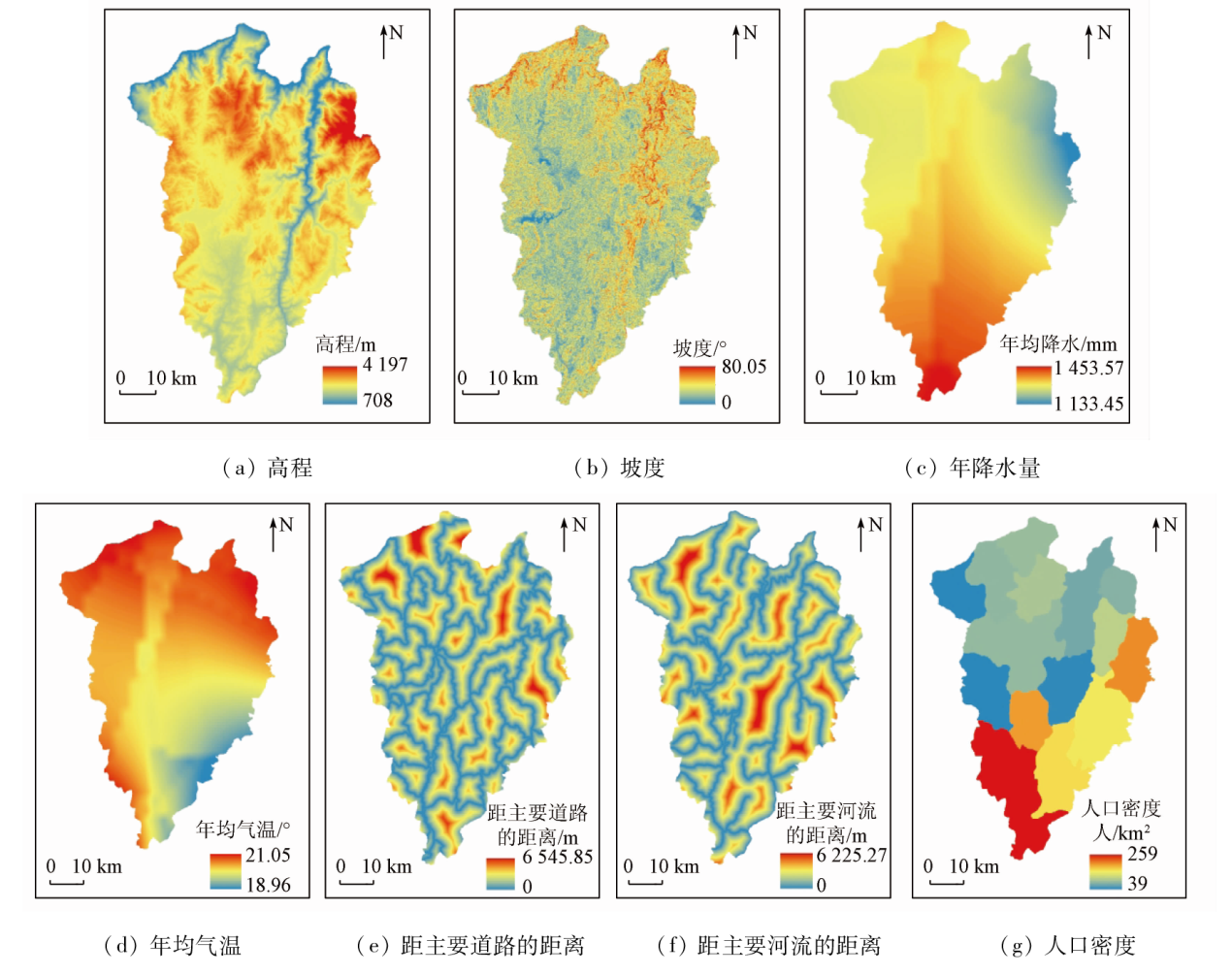
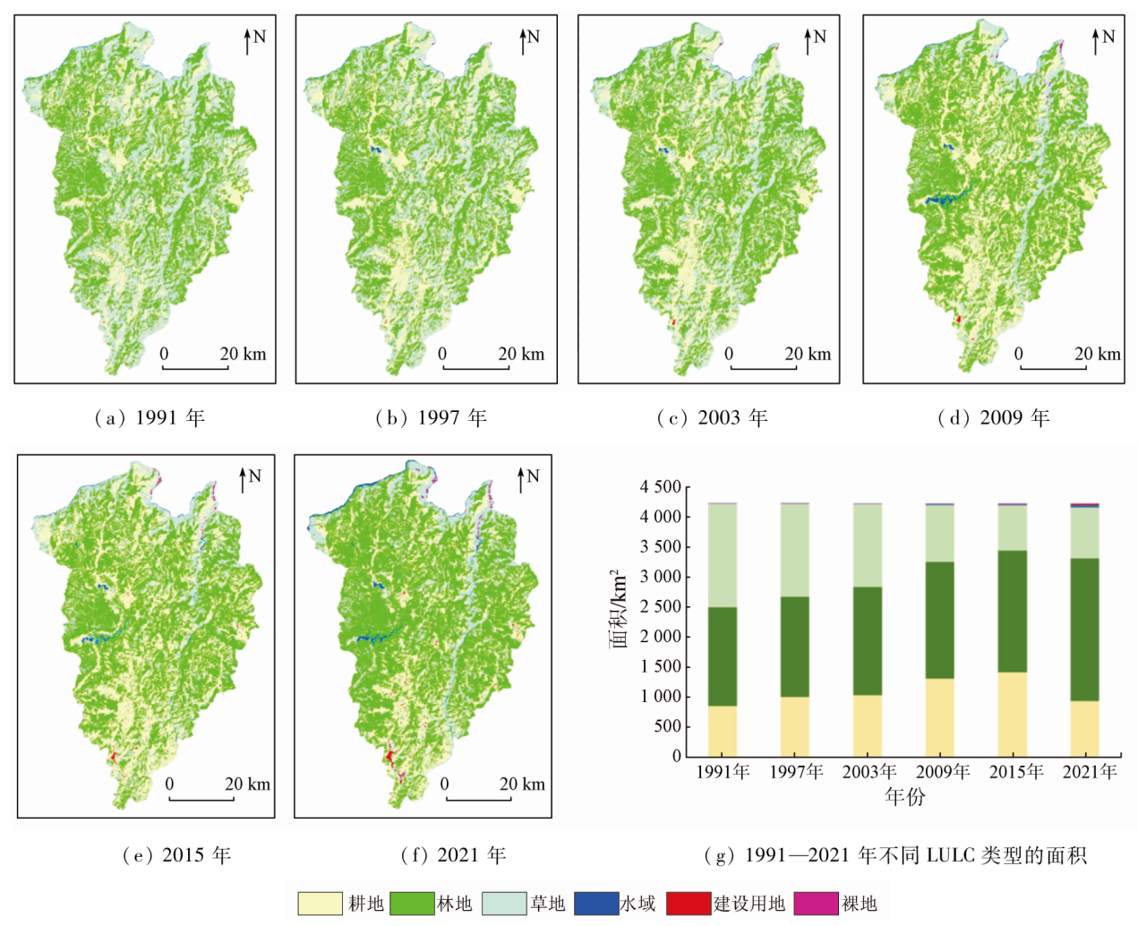
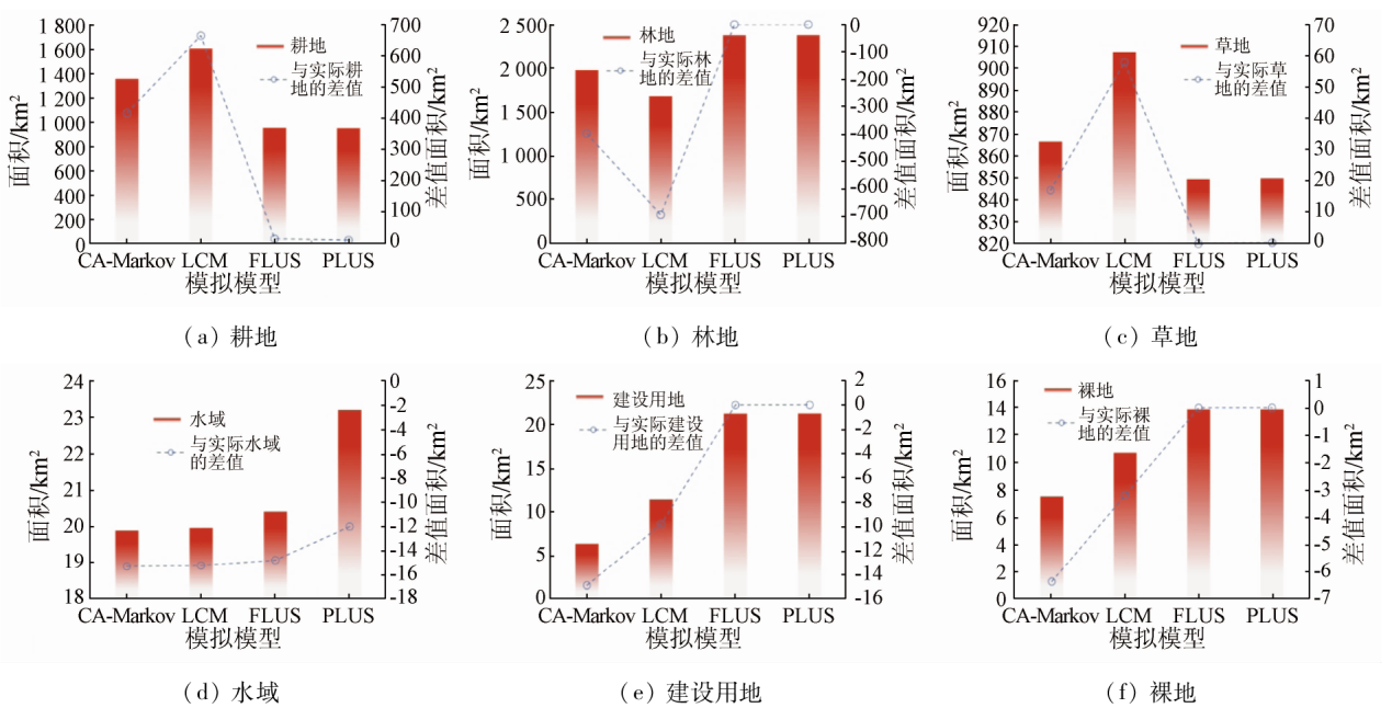
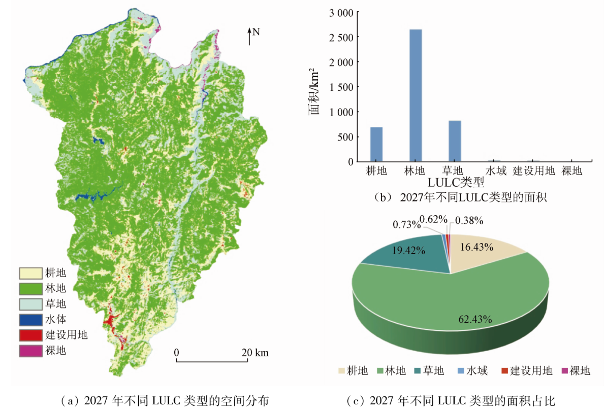
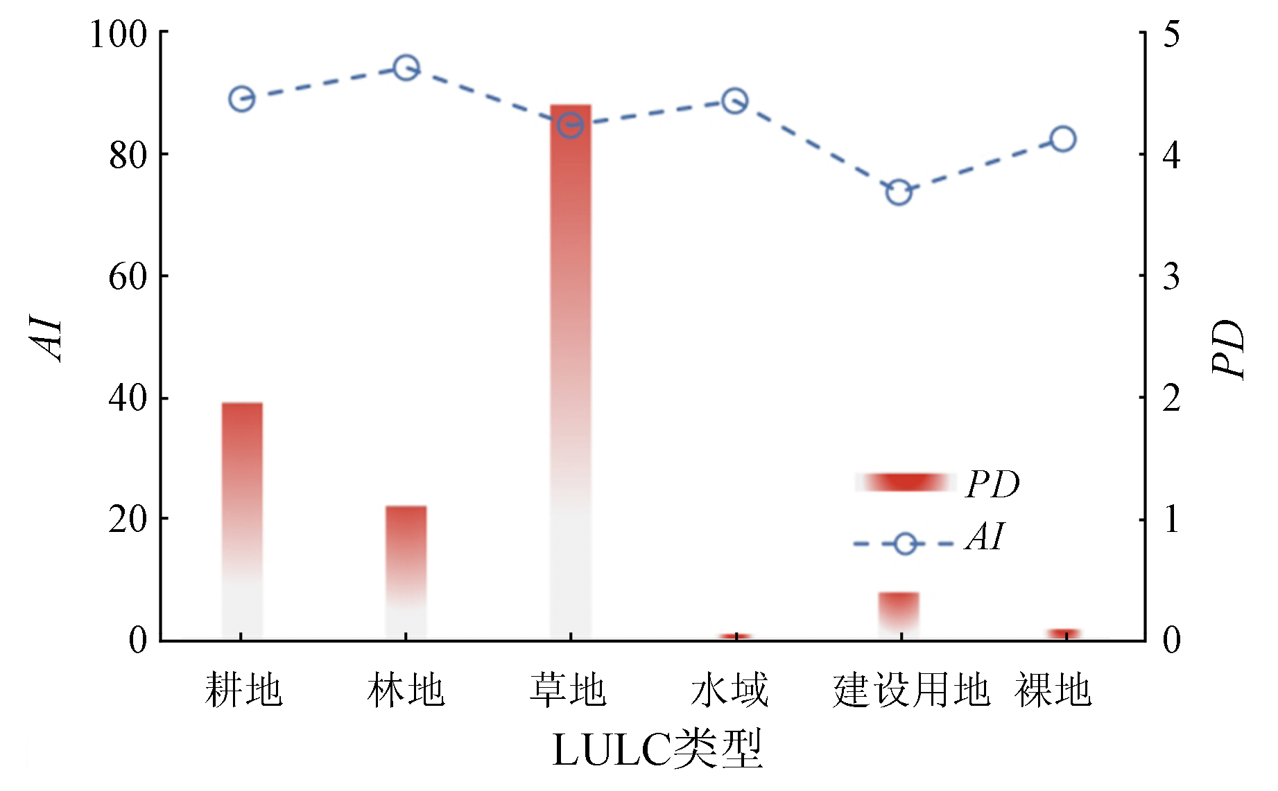
Abstract Land use/land cover (LULC) simulation is essential for research on changes in land use. Based on the Google Earth Engine (GEE) platform, this study extracted the high-precision LULC information of Luquan County from 1991 to 2021 and analyzed the spatio-temporal evolution pattern. Then, this study analyzed the factors driving LULC changes using a random forest model and compared the simulation results of Luquan County obtained using the cellular automata-Markov (CA-Markov), land change modeler (LCM), future land use simulation (FLUS), and patch-generating land use simulation (PLUS). Finally, this study forecast the LULC change scenario in Luquan County in 2027 using the optimal model. The results show that: ① From 1991 to 2021, the spatial LULC pattern of Luquan County was dominated by forestland, grassland, and farmland. The areas of farmland and waterbodies increased by 89.26 km2 and 27.72 km2, respectively, the areas of forestland, construction land, and bare land increased continuously by 724.25 km2, 21.08 km2, and 13.67 km2, respectively, and the grassland decreased at an annual average rate of 29.20 km2; ② The LULC in Luquan County was primarily influenced by topographic conditions (elevation and slope); ③ The simulation effects of the four LULC models were in the order of PLUS > FLUS > CA-Markov > LCM, with Kappa coefficient of 0.63, 0.58, 0.46 and 0.35, respectively and the overall accuracy of 0.78, 0.75, 0.66 and 0.58, respectively; ④ The spatial LULC pattern in Luquan County in 2027 will share similarities with that in 2021. From 2021 to 2027, the areas of farmland land, grassland, and water bodies will decrease at a rate of 40.21 km2/a, 4.51 km2/a, and 0.70 km2/a, respectively, while the forestland, construction land, and bare land will expand by 265.52 km2, 4.85 km2, and 2.08 km2, respectively.
|
| Keywords
LULC
random forest
multi-model
Luquan County
|
|
|
|
Issue Date: 21 December 2023
|
|
|
| [1] |
李少英, 刘小平, 黎夏, 等. 土地利用变化模拟模型及应用研究进展[J]. 遥感学报, 2017, 21(3):329-340.
|
| [1] |
Li S Y, Liu X P, Li X, et al. Simulation model of land use dynamics and application:Progress and prospects[J]. Journal of Remote Sensing, 2017, 21(3):329-340.
|
| [2] |
Eastman J R. IDRISI Andes guide to GlS and image processing[M]. America: Clark University, Worcester, 2006,87-131.
|
| [3] |
Yang J, Su J, Chen F, et al. A local land use competition cellular automata model and its application[J]. ISPRS International Journal of Geo-Information, 2016, 5(7):106.
doi: 10.3390/ijgi5070106
url: http://www.mdpi.com/2220-9964/5/7/106
|
| [4] |
Veldkamp A, Fresco L O. CLUE:A conceptual model to study the conversion of land use and its effects[J]. Ecological Modelling, 1996, 85(2/3):253-270.
doi: 10.1016/0304-3800(94)00151-0
url: https://linkinghub.elsevier.com/retrieve/pii/0304380094001510
|
| [5] |
Verburg P H, Soepboer W, Veldkamp A, et al. Modeling the spatial dynamics of regional land use:The CLUE- S model[J]. Environmental Management, 2002, 30(3):391-405.
pmid: 12148073
|
| [6] |
Liu X P, Liang X, Li X, et al. A future land use simulation model (FLUS) for simulating multiple land use scenarios by coupling human and natural effects[J]. Landscape and Urban Planning, 2017, 168:94-116.
doi: 10.1016/j.landurbplan.2017.09.019
url: https://linkinghub.elsevier.com/retrieve/pii/S0169204617302396
|
| [7] |
Liang X, Guan Q F, Clarke K C, et al. Understanding the drivers of sustainable land expansion using a patch-generating land use simulation (PLUS) model:A case study in Wuhan,China[J]. Computers,Environment and Urban Systems, 2021, 85:101569.
doi: 10.1016/j.compenvurbsys.2020.101569
url: https://linkinghub.elsevier.com/retrieve/pii/S0198971520303021
|
| [8] |
陆文涛, 代超, 郭怀成. 基于Dyna-CLUE模型的滇池流域土地利用情景设计与模拟[J]. 地理研究, 2015, 34(9):1619-1629.
doi: 10.11821/dlyj201509002
|
| [8] |
Lu W T, Dai C, Guo H C. Land use scenario design and simulation based on Dyna-CLUE model in Dianchi Lake Watershed[J]. Geographical Research, 2015, 34(9):1619-1629.
doi: 10.11821/dlyj201509002
|
| [9] |
Sakayarote K, Shrestha R P. Simulating land use for protecting food crop areas in northeast Thailand using GIS and Dyna-CLUE[J]. Journal of Geographical Sciences, 2019, 29(5):803-817.
doi: 10.1007/s11442-019-1629-7
|
| [10] |
Chen Z Z, Huang M, Zhu D Y, et al. Integrating remote sensing and a Markov-FLUS model to simulate future land use changes in Hokkaido,Japan[J]. Remote Sensing, 2021, 13(13):2621.
doi: 10.3390/rs13132621
url: https://www.mdpi.com/2072-4292/13/13/2621
|
| [11] |
Darvishi A, Yousefi M, Marull J. Modelling landscape ecological assessments of land use and cover change scenarios.Application to the Bojnourd Metropolitan Area (NE Iran)[J]. Land Use Policy, 2020, 99:105098.
doi: 10.1016/j.landusepol.2020.105098
url: https://linkinghub.elsevier.com/retrieve/pii/S0264837719319015
|
| [12] |
林伊琳, 赵俊三, 陈国平, 等. 基于MCR-FLUS-Markov模型的区域国土空间格局优化[J]. 农业机械学报, 2021, 52(4):159-170,207.
|
| [12] |
Lin Y L, Zhao J S, Chen G P, et al. Optimization of regional territory space pattern based on MCR-FLUS-Markov model[J]. Transactions of the Chinese Society for Agricultural Machinery, 2021, 52(4):159-170,207.
|
| [13] |
崔旺来, 蔡莉, 奚恒辉, 等. 基于土地利用/覆盖变化的浙江大湾区生态安全评价及多情景模拟分析[J]. 生态学报, 2022, 42(6):2136-2148.
|
| [13] |
Cui W L, Cai L, Xi H H, et al. Ecological security assessment and multi-scenario simulation analysis of Zhejiang Greater Bay Area based on LUCC[J]. Acta Ecologica Sinica, 2022, 42(6): 2136-2148.
|
| [14] |
林丽, 樊辉, 金缘. 山区县域土地利用/覆被变化多尺度多模型模拟对比——以云南省勐腊县为例[J]. 山地学报, 2020, 38(4):630-642.
|
| [14] |
Lin L, Fan H, Jin Y. Multi-scale and multi-model simulation of land use/ land cover change in the mountainous county:A case study of Mengla County in Yunnan Province,China[J]. Mountain Research, 2020, 38(4):630-642.
|
| [15] |
杨济达, 欧晓昆, 呙靖雯, 等. 基于CA-Markov和Geomod模型橡胶林变化预测比较[J]. 山地学报, 2014, 32(3):267-276.
|
| [15] |
Yang J D, Ou X K, Guo J W, et al. Comparison of CA-Markov and geomod models for rubber plantation prediction[J]. Mountain Research, 2014, 32(3):267-276.
|
| [16] |
陈柯欣, 丛丕福, 卢伟志, 等. CA-Markov与LCM模型的黄河三角洲湿地变化模拟比较[J]. 地球信息科学学报, 2019, 21(12):1903-1910.
doi: 10.12082/dqxxkx.2019.180660
|
| [16] |
Chen K X, Cong P F, Lu W Z, et al. Comparison of the CA-Markov and LCM models in simulating wetland change in the Yellow River Delta[J]. Journal of Geo-information Science, 2019, 21(12):1903-1910.
|
| [17] |
Wang J, Zhang J P, Xiong N N, et al. Spatial and temporal variation,simulation and prediction of land use in ecological conservation area of western Beijing[J]. Remote Sensing, 2022, 14(6):1452.
doi: 10.3390/rs14061452
url: https://www.mdpi.com/2072-4292/14/6/1452
|
| [18] |
赵学斌. 巩固提升产业扶贫成果与乡村产业振兴有效衔接——以昆明市禄劝县为例[D]. 昆明: 云南师范大学, 2022.
|
| [18] |
Zhao X B. Consolidate and enhance the achievements of industrial poverty alleviation and the revitalization of rural industries effective connection:A case of study of Luquan County,Kunming[D]. Kunming: Yunnan Normal University, 2022.
|
| [19] |
饶凯. 典型高山峡谷生态脆弱县土地生态安全评价研究——以云南禄劝彝族苗族自治县为例[D]. 昆明: 云南财经大学, 2020.
|
| [19] |
Rao K. A study on the land ecological security evaluation of typical mountain and canyon ecologically fragile counties:A case study of Luquan Yi and Miao Autonomous County in Yunnan Province[D]. Kunming: Yunnan university of finance and economics, 2020.
|
| [20] |
Li J, Wang J L, Zhang J, et al. Growing-season vegetation coverage patterns and driving factors in the China-Myanmar Economic Corridor based on Google Earth Engine and geographic detector[J]. Ecological Indicators, 2022, 136:108620.
doi: 10.1016/j.ecolind.2022.108620
url: https://linkinghub.elsevier.com/retrieve/pii/S1470160X22000917
|
| [21] |
左岍, 周勇, 李晴, 等. 鄂西南地区土地利用格局时空变化及轨迹特征分析[J]. 水土保持学报, 2022, 36(1):161-169.
|
| [21] |
Zuo Q, Zhou Y, Li Q, et al. Analysis of spatial and temporal changes and trajectory characteristics of land use pattern in the southwest Hubei[J]. Journal of Soil and Water Conservation, 2022, 36(1):161-169.
|
| [22] |
徐新良, 刘纪远, 张树文, 等. 中国多时期土地利用土地覆被遥感监测数据集(CNLUCC)[EB/OL]. 中国科学院地理科学与资源研究所数据注册与出版系统(http://www.resdc.cn/DOI ), 2018.
url: http://www.resdc.cn/DOI
|
| [22] |
Xu X L, Liu J Y, Zhang S W, et al. Multi period remote sensing monitoring data set of land use and land cover in China (CNLUCC)[EB/OL]. Data Registration and Publishing System of Institute of Geographic Sciences and Resources,Chinese Academy of Sciences (http://www.resdc.cn/DOI ), 2018.
url: http://www.resdc.cn/DOI
|
| [23] |
Yang J, Huang X. The 30 m annual land cover dataset and its dynamics in China from 1990 to 2019[J]. Earth System Science Data, 2021, 13(8): 3907-3925.
doi: 10.5194/essd-13-3907-2021
url: https://essd.copernicus.org/articles/13/3907/2021/
|
| [24] |
Jun C, Ban Y F, Li S N. China:Open access to Earth land-cover map[J]. Nature, 2014, 514(7523): 434.
|
| [25] |
Liu C L, Li W L, Zhu G F, et al. Land use/land cover changes and their driving factors in the northeastern Tibetan Plateau based on geographical detectors and Google earth engine: A case study in Gannan prefecture[J]. Remote Sensing, 2020, 12:3139.
doi: 10.3390/rs12193139
url: https://www.mdpi.com/2072-4292/12/19/3139
|
| [26] |
Zhai R T, Zhang C R, Li W D, et al. Evaluation of driving forces of land use and land cover change in new England area by a mixed method[J]. ISPRS International Journal of Geo-Information, 2020, 9(6):350.
doi: 10.3390/ijgi9060350
url: https://www.mdpi.com/2220-9964/9/6/350
|
| [27] |
李柳华, 刘小平, 欧金沛, 等. 基于随机森林模型的城市扩张三维特征时空变化及机制分析[J]. 地理与地理信息科学, 2019, 35(2):53-60.
|
| [27] |
Li L H, Liu X P, Ou J P, et al. Spatio-temporal changes and mechanism analysis of urban 3D expansion based on random forest model[J]. Geography and Geo-Information Science, 2019, 35(2):53-60.
|
| [28] |
郭平, 周伟, 袁涛, 等. 衰退型资源城市土地利用时空变化及驱动因素分析[J]. 水土保持研究, 2016, 23(4):191-198.
|
| [28] |
Guo P, Zhou W, Yuan T, et al. Analysis on the temporal and spatial change of land use and its driving factors of declining resources-based city[J]. Research of Soil and Water Conservation, 2016, 23(4):191-198.
|
| [29] |
王旭东, 姚尧, 任书良, 等. 耦合FLUS和Markov的快速发展城市土地利用空间格局模拟方法[J]. 地球信息科学学报, 2022, 24(1):100-113.
doi: 10.12082/dqxxkx.2022.210359
|
| [29] |
Wang X D, Yao Y, Ren S L, et al. A coupled FLUS and Markov approach to simulate the spatial pattern of land use in rapidly developing cities[J]. Journal of Geo-information Science, 2022, 24(1):100-113.
|
| [30] |
田晶, 郭生练, 刘德地, 等. 气候与土地利用变化对汉江流域径流的影响[J]. 地理学报, 2020, 75(11):2307-2318.
doi: 10.11821/dlxb202011003
|
| [30] |
Tian J, Guo S L, Liu D D, et al. Impacts of climate and land use/cover changes on runoff in the Hanjiang River Basin[J]. Acta Geographica Sinica, 2020, 75(11):2307-2318.
doi: 10.11821/dlxb202011003
|
| [31] |
李金雷, 刘欢, 哈斯娜, 等. 岱海流域土地利用动态模拟及生态系统服务价值测算[J]. 生态学杂志, 2022, 41(2):343-350.
|
| [31] |
Li J L, Liu H, Ha S N, et al. Simulation of land use and evaluation of ecosystem service value in Daihai Basin[J]. Chinese Journal of Ecology, 2022, 41(2):343-350.
|
| [32] |
郑青华, 罗格平, 朱磊, 等. 基于CA-Markov模型的伊犁河三角洲景观格局预测[J]. 应用生态学报, 2010, 21(4):873-882.
|
| [32] |
Zheng Q H, Luo G P, Zhu L, et al. Prediction of landscape patterns in Ili River Delta based on CA-Markov model[J]. Chinese Journal of Applied Ecology, 2010, 21(4):873-882.
|
| [33] |
林媚珍, 刘汉仪, 周汝波, 等. 多情景模拟下粤港澳大湾区生态系统服务评估与权衡研究[J]. 地理研究, 2021, 40(9):2657-2669.
doi: 10.11821/dlyj020200943
|
| [33] |
Lin M Z, Liu H Y, Zhou R B, et al. Evaluation and trade-offs of ecosystem services in Guangdong-Hong Kong-Macao Greater Bay Area under multi-scenario simulation[J]. Geographical Research, 2021, 40(9):2657-2669.
doi: 10.11821/dlyj020200943
|
| [34] |
王佳楠, 张志. 基于Markov-PLUS模型的柴北缘土地利用变化及模拟分析[J]. 西北林学院学报, 2022, 37(3):139-148,179.
|
| [34] |
Wang J N, Zhang Z. Land use change and simulation analysis in the northern margin of the Qaidam Basin based on Markov-PLUS model[J]. Journal of Northwest Forestry University, 2022, 37(3):139-148,179.
|
| [35] |
Zheng W, Shen Q P, Wang H, et al. Simulating land use change in urban renewal areas:A case study in Hong Kong[J]. Habitat International, 2015, 46: 23-34.
doi: 10.1016/j.habitatint.2014.10.008
url: https://linkinghub.elsevier.com/retrieve/pii/S0197397514001465
|
| [36] |
付扬军, 师学义, 和娟. 汾河流域景观破碎化时空演变特征[J]. 自然资源学报, 2019, 34(8):1606-1619.
|
| [36] |
Fu Y J, Shi X Y, He J. The spatio-temporal evolution characteristics of landscape fragmentation in Fenhe River Basin[J]. Journal of Natural Resources, 2019, 34(8):1606-1619.
doi: 10.31497/zrzyxb.20190804
|
| [37] |
刘世梁, 安南南, 侯笑云, 等. 澜沧江下游景观破碎化时空动态及成因分析[J]. 生态环境学报, 2018, 27(7):1351-1358.
doi: 10.16258/j.cnki.1674-5906.2018.07.020
|
| [37] |
Liu S L, An N N, Hou X Y, et al. Spatio-temporal dynamics of landscape fragmentation and its influencing analysis in the downstream of Lancang River Basin[J]. Ecology and Environmental Sciences, 2018, 27(7):1351-1358.
|
| [38] |
邵大伟, 吴殿鸣. 景观破碎化对生态系统服务价值的影响作用分析——以苏州为例[J]. 长江流域资源与环境, 2020, 29(11):2436-2449.
|
| [38] |
Shao D W, Wu D M. Analysis on the effect of landscape fragmentation on ecosystem service value:A case study of Suzhou[J]. Resources and Environment in the Yangtze Basin, 2020, 29(11):2436-2449.
|
| [39] |
梁加乐, 陈万旭, 李江风, 等. 黄河流域景观破碎化时空特征及其成因探测[J]. 生态学报, 2022, 42(5):1993-2009.
|
| [39] |
Liang J L, Chen W X, Li J F, et al. Spatiotemporal patterns of landscape fragmentation and causes in the Yellow River Basin[J]. Acta Ecologica Sinica, 2022, 42(5):1993-2009.
|
|
Viewed |
|
|
|
Full text
|
|
|
|
|
Abstract
|
|
|
|
|
Cited |
|
|
|
|
| |
Shared |
|
|
|
|
| |
Discussed |
|
|
|
|
 2023,
Vol. 35
2023,
Vol. 35