|
|
 |
|

|
|
|
Research on downscaling of TRMM data in the Tibetan Plateau based on GWR model |
Junnan XIONG1,2, Wei LI1, Zhiqi LIU3, Weiming CHENG2( ), Chunkun FAN4, Jin LI1 ), Chunkun FAN4, Jin LI1 |
1. School of Civil Engineering and Geomatics, Southwest Petroleum University, Chengdu, 610500, China
2. State Key Laboratory of Resources and Environmental Information System, Institute of Geographic and Natural Resources Research, Chinese Academy of Sciences, Beijing 100101, China
3. Sichuan Provincial Coalfield Surveying and Mapping Engineering Institute, Chengdu 610072, China
4. Agriculture Research Institute, Tibet Academy of Agriculture and Animal Husbandry Sciences, Lhasa 850000, China |
|
|
|
|
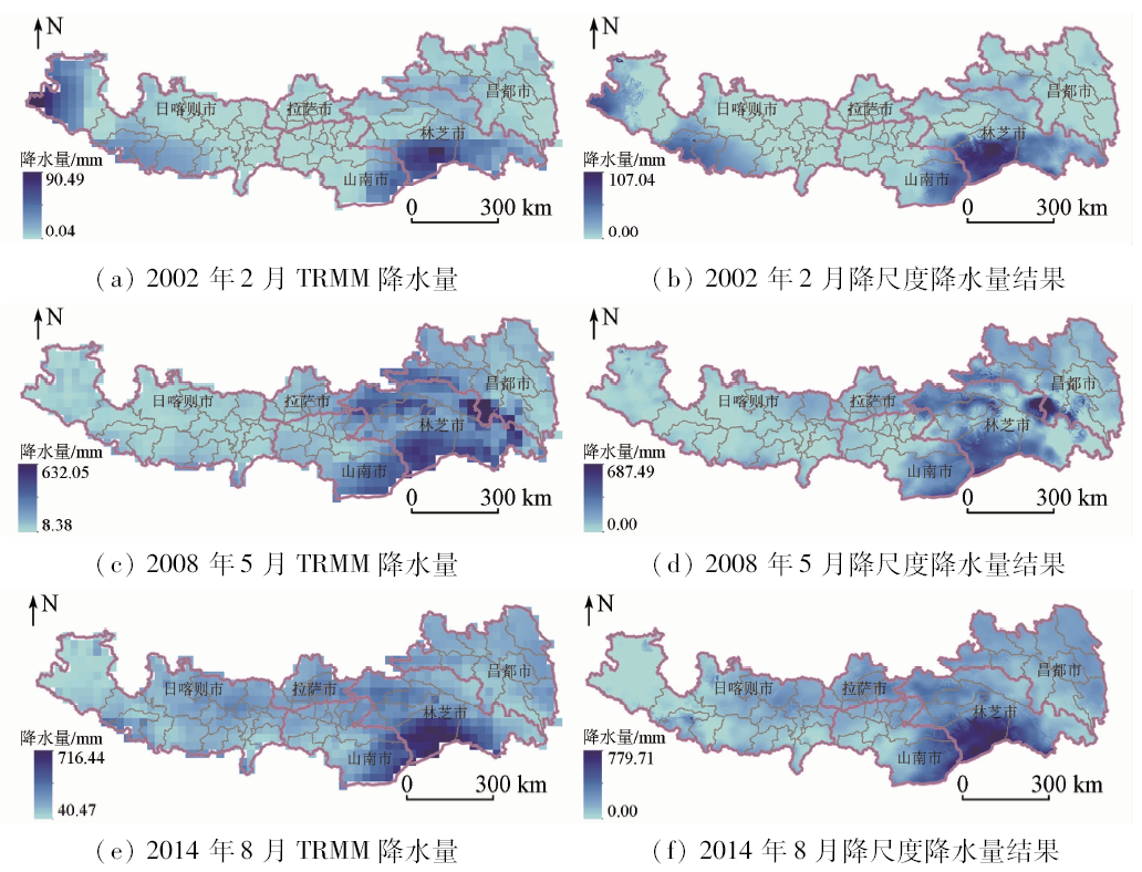
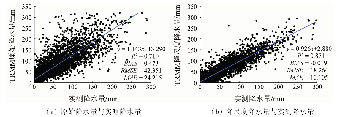
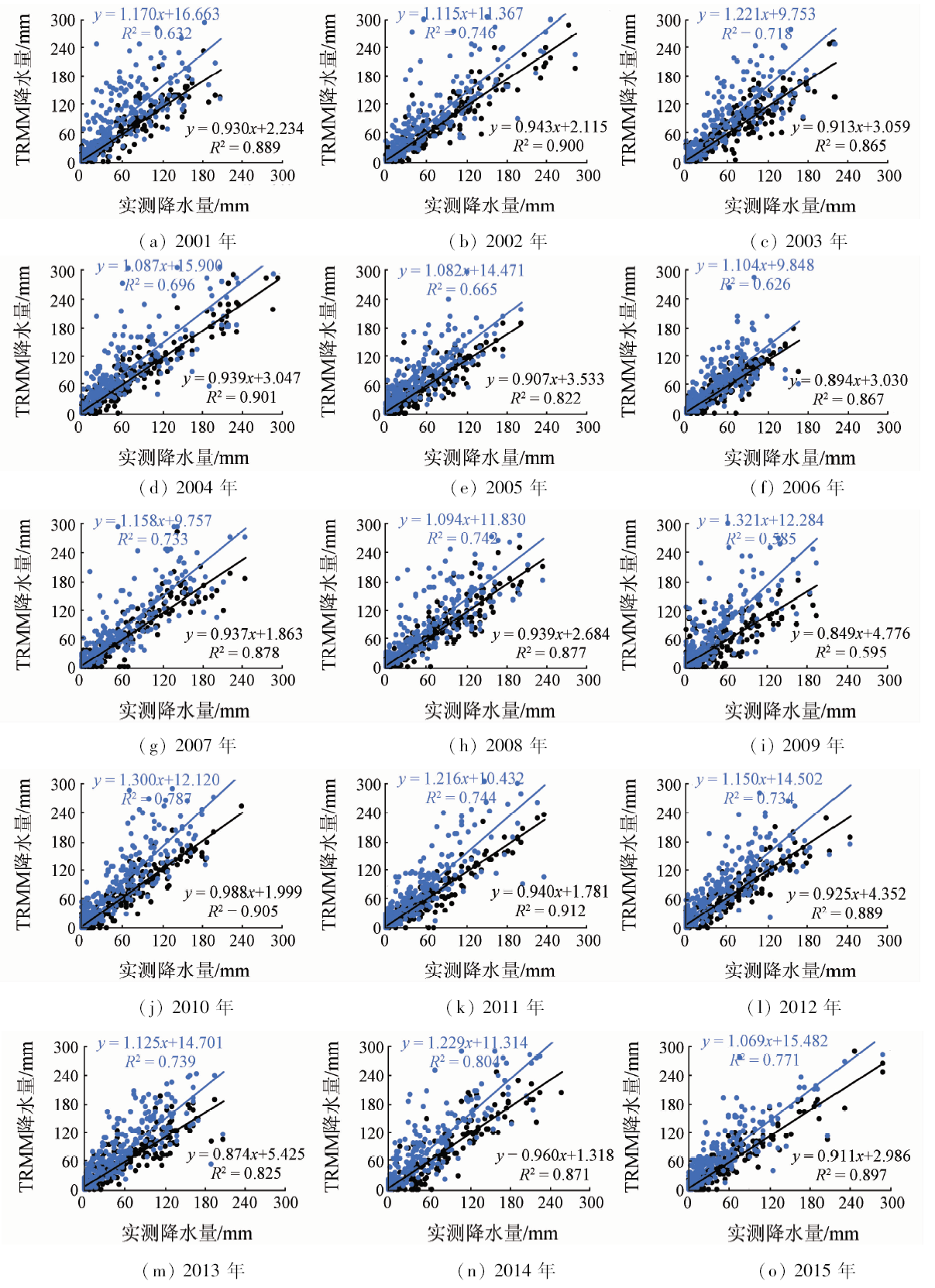
Abstract The complex climatic environment and topographical structure of the Tibetan Plateau region have caused great troubles for the observation of hydrometeorological data. The lack of effective high-temporal resolution observation data has become an important obstacle to regional meteorological forecasting and prediction. Based on the 2001—2015 tropical rainfall measurement mission (TRMM) precipitation product, the authors used the 1 km resolution enhanced vegetation index (EVI) spatial data to calculate the downscaling based on the geographically weighted regression(GWR) model. The downscaling results at the annual and monthly scales were tested and compared with the measured data from the ground stations. The results show that the spatial distribution characteristics of TRMM products before and after downscaling are generally consistent, but the accuracy of the results after downscaling is significantly higher than that of the original TRMM products. From 2001 to 2015, the correlation coefficient R 2 of the precipitation of TRMM products after downscaling and the actual ground precipitation was higher than that of original TRMM, and the RMSE and MAE decreased by 21.652 mm and 16.379 mm, respectively. During these years, the accuracy of the original precipitation of TRMM products was relatively low, and hence further correction is required in utilization. The degree of fitting of the TRMM precipitation with the measured precipitation was significantly improved, except for June, August and November, R 2 in other months was 0.65 or even higher, showing good consistency and applicability.
|
| Keywords
GWR
Tibetan Plateau region
TRMM
downscaling
|
|
|
|
Corresponding Authors:
Weiming CHENG
E-mail: chengwm@lreis.ac.cn
|
|
Issue Date: 03 December 2019
|
|
|
| [1] |
Plouffe C C F, Robertson C, Chandrapala L . Comparing interpolation techniques for monthly rainfall mapping using multiple evaluation criteria and auxiliary data sources:A case study of Sri Lanka[J]. Environmental Modelling and Software, 2015,67(C):57-71.
|
| [2] |
刘海江, 尹思阳, 孙聪 , 等. 2000—2010年锡林郭勒草原NPP时空变化及其气候响应[J]. 草业科学, 2015,32(11):1709-1720.
doi: 10.11829/j.issn.1001-0629.2015-0371
|
| [2] |
Liu H J, Yin S Y, Sun C , et al. Temporal and spatial variation of net primary productivity(NPP) and its responses with climatic changes in the Xilingol grassland from 2000 to 2010[J]. Pratacultural Science, 2015,32(11):1709-1720.
|
| [3] |
罗春, 刘辉, 戚陆越 . 基于遥感指数的生态变化评估——以常宁市为例[J]. 国土资源遥感, 2014,26(4):145-150.doi: 10.6046/gtzyyg.2014.04.23
doi: 10.6046/gtzyyg.2014.04.23
url: http://d.wanfangdata.com.cn/Periodical/gtzyyg201404024
|
| [3] |
Luo C, Liu H, Qi L Y . Ecological changes assessment based on remote sensing indices:A case study of Changning City[J]. Remote Sensing for Land and Resources, 2014,26(4):145-150.doi: 10.6046/gtzyyg.2014.04.23
|
| [4] |
陈诚, 赵书河 . 基于TRMM降雨数据的中国黄淮海地区干旱监测分析[J]. 国土资源遥感, 2016,28(1):122-129.doi: 10.6046/gtzyyg.2016.01.18
doi: 10.6046/gtzyyg.2016.01.18
|
| [4] |
Chen C, Zhao S H . Drought monitoring and analysis of Huanghuai Hai plain based on TRMM precipitation data[J]. Remote Sensing for Land and Resources, 2016,28(1):122-129.doi: 10.6046/gtzyyg.2016.01.18
|
| [5] |
Liu J, Zhu A, Duan Z . Evaluation of TRMM 3B42 precipitation product using rain gauge data in Meichuan watershed,Poyang Lake basin,China[J]. Journal of Resources and Ecology, 2012,3(4):359-366.
|
| [6] |
Kizza M, Westerberg I, Rodhe A, et al.Estimating areal rainfall over Lake Victoria and its basin using ground-based and satellite data[J].Journal of Hydrology , 2012, 464- 465:401-411.
|
| [7] |
吕洋, 杨胜天, 蔡明勇 , 等. TRMM卫星降水数据在雅鲁藏布江流域的适用性分析[J]. 自然资源学报, 2013,28(8):1414-1425.
doi: 10.11849/zrzyxb.2013.08.014
|
| [7] |
Lyu Y, Yang S T, Cai M Y , et al. The applicability analysis of TRMM precipitation data in the Yarlung Zangbo River basin[J]. Journal of Natural Resources, 2013,28(8):1414-1425.
|
| [8] |
刘赛艳, 黄强, 王义民 , 等. 基于统计降尺度和CMIP5模式的泾河流域气候要素模拟与预估[J]. 农业工程学报, 2015,31(23):138-144.
|
| [8] |
Liu S Y, Huang Q, Wang Y M , et al. Simulation and prediction of climatic elements in Jinghe River basin using downscaling method and CMIP5[J]. Transactions of the Chinese Society of Agricultural Engineering, 2015,31(23):138-144.
|
| [9] |
陈诚 . TRMM 3B43遥感降水量产品数据定标与降尺度方法研究[D]. 南京:南京大学, 2016.
|
| [9] |
Chen C . Calibration and Spatial Downscaling of TRMM 3B43 Precipitation Product[D]. Nanjing:Nanjing University, 2016.
|
| [10] |
Wong W F J. Spatial and temporal analysis of MODIS EVI and TRMM 3B43 rainfall retrievals in Australia [C]//International Conference on Geoinformatics.IEEE, 2011: 1-7.
|
| [11] |
Gessner U, Naeimi V, Klein I , et al. The relationship between precipitation anomalies and satellite-derived vegetation activity in Central Asia[J]. Global and Planetary Change, 2013,110:74-87.
|
| [12] |
Quiroz R, Yarlequé C, Posadas A , et al. Improving daily rainfall estimation from NDVI using a wavelet transform[J]. Environmental Modelling and Software, 2011,26(2):201-209.
|
| [13] |
Shi Y, Song L . Spatial downscaling of monthly TRMM precipitation based on EVI and other geospatial variables over the Tibetan Plateau from 2001 to 2012[J]. Mountain Research and Development, 2015,35(2):180-194.
|
| [14] |
宋蕾 . 基于TRMM 3B43青藏高原区域性高时空分辨率降水探究[D]. 南京:南京信息工程大学, 2015.
|
| [14] |
Song L . Study on Regional Precipitation Product with High Spatial-Temporal Resolution over the Tibetan Plateau Based on TRMM 3B43[D]. Nanjing:Nanjing University of Information Science and Technology, 2015.
|
| [15] |
李净, 张晓 . TRMM降水数据的空间降尺度方法研究[J]. 地理科学, 2015,35(9):1164-1169.
doi: 10.11820/dlkxjz.2000.02.002
url: http://d.wanfangdata.com.cn/Periodical/dlkx201509013
|
| [15] |
Li J, Zhang X . Downscaling method of TRMM satellite precipitation data[J]. Scientia Geographica Sinica, 2015,35(9):1164-1169.
|
| [16] |
范雪薇, 刘海隆 . 天山山区TRMM降水数据的空间降尺度研究[J]. 自然资源学报, 2018,33(3):478-488.
|
| [16] |
Fan X W, Liu H L . Downscaling method of TRMM satellite precipitation data over the Tianshan Mountains[J]. Journal of Natural Resources, 2018,33(3):478-488.
|
| [17] |
王晓杰 . 基于TRMM的天山山区降水降尺度方法及其空间变异特征研究[D]. 石河子:石河子大学, 2013.
|
| [17] |
Wang X J . Downscaling Method and Spatial Variability of Precipitation in Tianshan Mountain on the TRMM Data[D]. Shihezi:Shihezi University, 2013.
|
| [18] |
Brunsdon C, Fotheringham A S, Charlton M E . Geographically weighted regression:A method for exploring spatial nonstationarity[J]. Journal of the Royal Statistical Society, 2017,47(3):431-443.
|
| [19] |
姚永慧, 张百平 . 基于MODIS数据的青藏高原气温与增温效应估算[J]. 地理学报, 2013,68(1):95-107.
doi: 10.11821/xb201301011
|
| [19] |
Yao Y H, Zhang B P . MODIS-based estimation of air temperature and heating-up effect of the Tibetan Plateau[J]. Acta Geographica Sinica, 2013,68(1):95-107.
|
| [20] |
McMillen D P . Geographically weighted regression:The analysis of spatially varying relationships[J]. American Journal of Agricultural Economics, 2004,86(2):554-556.
|
| [21] |
王佳, 钱雨果, 韩立建 , 等. 基于GWR模型的土地覆盖与地表温度的关系——以京津唐城市群为例[J]. 应用生态学报, 2016,27(7):2128-2136.
|
| [21] |
Wang J, Qian Y G, Han L J , et al. Relationship between land surface temperature and land cover types based on GWR model:A case of Beijing-Tianjin-Tangshan urban agglomeration,China[J]. The journal of applied ecology, 2016,27(7):2128-2136.
|
| [22] |
卢新玉, 魏鸣, 王秀琴 , 等. TRMM-3B43降水产品在新疆地区的适用性研究[J]. 国土资源遥感, 2016,28(3):166-173.doi: 10.6046/gtzyyg.2016.03.26
doi: 10.6046/gtzyyg.2016.03.26
|
| [22] |
Lu X Y, Wei M, Wang X Q , et al. Applicability research on TRMM-3B43 precipitation over Xinjiang[J]. Remote Sensing for Land and Resources, 2016,28(3):166-173.doi: 10.6046/gtzyyg.2016.03.26
|
| [23] |
周秋文, 李芳 . TRMM降雨数据在喀斯特地区的适用性分析——以贵州省为例[J]. 水资源与水工程学报, 2018,29(2):76-83.
|
| [23] |
Zhou Q W, Li F . Applicability analysis of the TRMM precipitation data in Karst region:A case study in Guizhou Province,China[J]. Journal of Water Resources and Water Engineering, 2018,29(2):76-83.
|
|
Viewed |
|
|
|
Full text
|
|
|
|
|
Abstract
|
|
|
|
|
Cited |
|
|
|
|
| |
Shared |
|
|
|
|
| |
Discussed |
|
|
|
|
 2019,
Vol. 31
2019,
Vol. 31