|
|
|
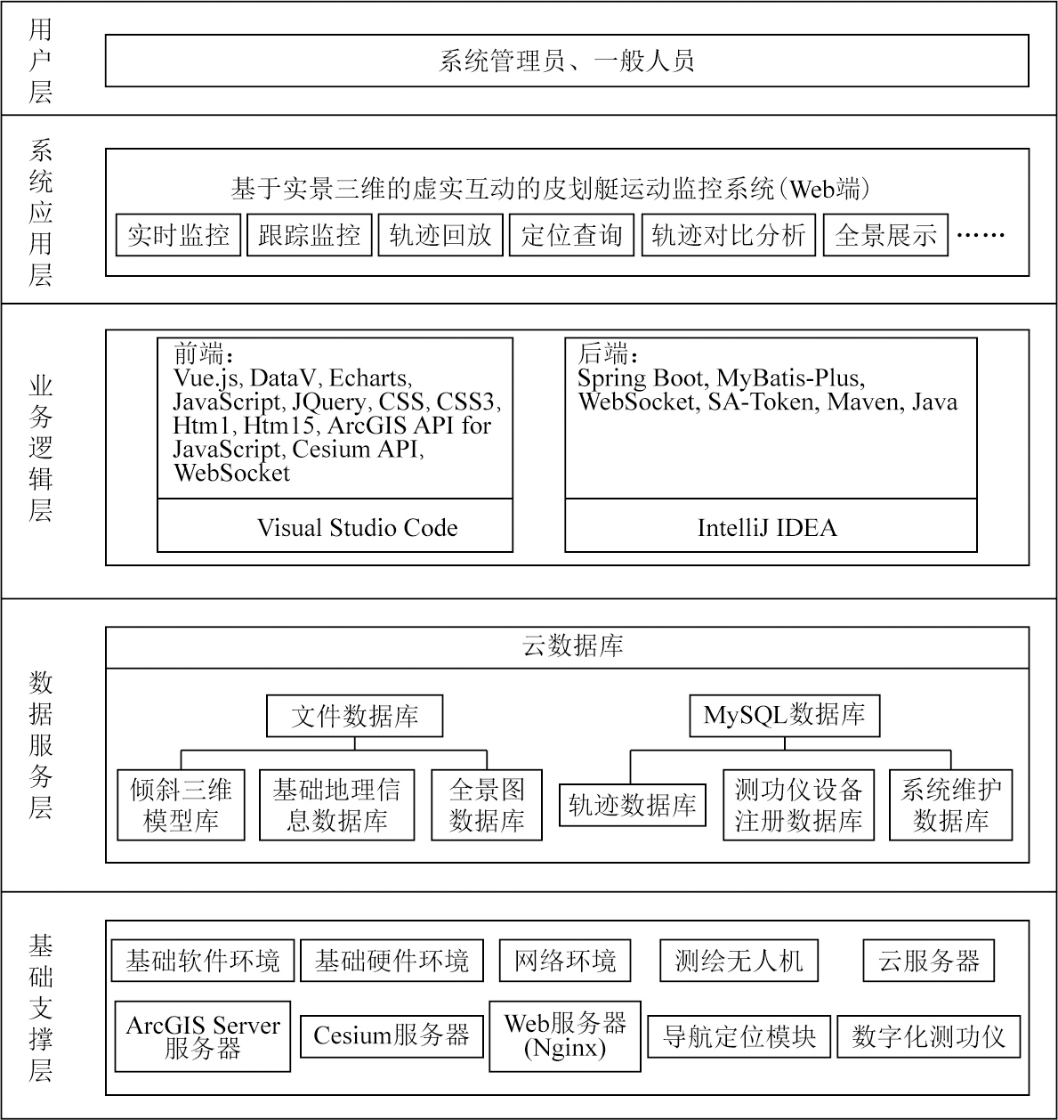
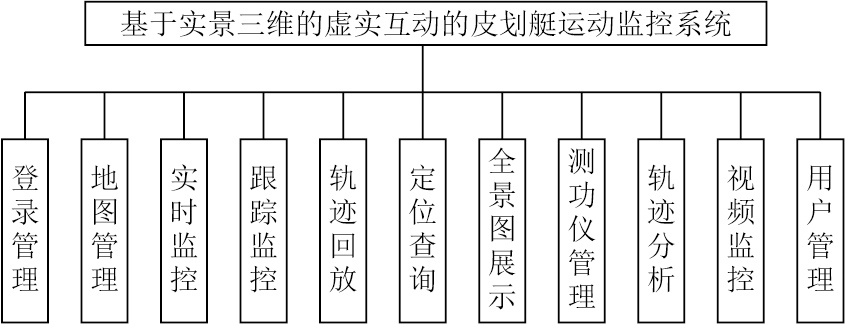
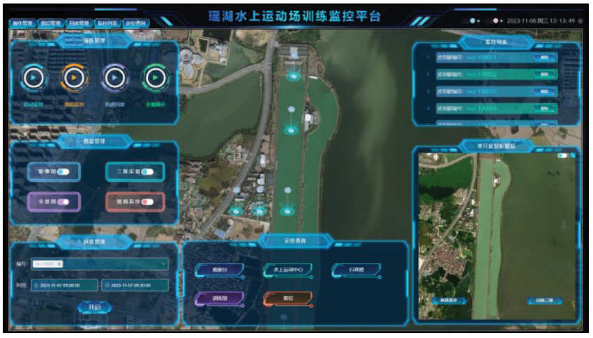
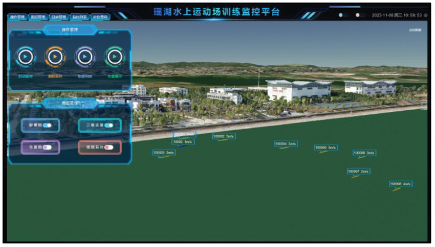
Abstract Canoeing is an important Olympic event; however, high-precision positioning and map data visualization technologies have not been widely adopted during the training phase of canoeing. To bridge this gap, this study proposed a domestically pioneering canoeing sport monitoring system based on real-scene 3D. This system integrates high-precision positioning, virtual reality (VR), and virtual-real fusion technologies, providing athletes and coaches with a straightforward, precise data analysis platform. First, this study presents an overview of the background and significance of the construction of the system. Then, it describes the architecture, major functions, and database design of the system. Finally, it introduces the software system development using technologies including the Cesium platform for 3D geospatial applications, ArcGIS Server, ArcGIS API for JavaScript, and WebSocket. The methods for developing key functions are also described. The core functions encompass 3D visualization of the training field, venue query and positioning, virtual-real integration of trajectories, real-time positioning and monitoring, trajectory playback, and data analysis. Therefore, this system enjoys the advances of high-precision positioning, 3D real scene visualization, and virtual-real fusion. The applications of this system will enhance the efficiency and quality of canoeing training and provide a valuable reference for related research fields.
|
| Keywords
canoeing
geographic information system (GIS)
real-scene 3D
positioning monitoring
data analysis
|
|
|
|
Issue Date: 03 September 2025
|
|
|
| [1] |
田中, 陈贵岐. 皮划艇项目的训练监控[J]. 沈阳体育学院学报, 2011, 30(5):87-90.
|
| [1] |
Tian Z, Chen G Q. Training monitoring in kayak/canoe event[J]. Journal of Shenyang Sport University, 2011, 30(5):87-90.
|
| [2] |
胡璞, 易名农, 刘嘉. 基于多传感器数据融合技术的水上训练监控系统的研制与应用[J]. 武汉体育学院学报, 2015, 49(3):96-100.
|
| [2] |
Hu P, Yi M N, Liu J. Development and application of supervision and evaluation system based on data integration of multi-sensors for water training of rowing[J]. Journal of Wuhan Institute of Phy-sical Education, 2015, 49(3):96-100.
|
| [3] |
杜芸芸, 杨海英. 激流回旋视频监测系统研制[J]. 武汉体育学院学报, 2013, 47(10):77-80.
|
| [3] |
Du Y Y, Yang H Y. Development of video monitoring system of whitewater slalom based on cloud computing[J]. Journal of Wuhan Institute of Physical Education, 2013, 47(10):77-80.
|
| [4] |
李媛, 史东林, 纪霄峰, 等. 皮划艇训练状态多参数遥测装置的研制[J]. 当代体育科技, 2014, 4(5):18-19.
|
| [4] |
Li Y, Shi D L, Ji X F, et al. Development of real-time information kayaking training status of multi-parameter telemetry[J]. Contemporary Sports Technology, 2014, 4(5):18-19.
|
| [5] |
孙晋海, 王家宏, 马运超, 等. 基于多传感器的皮划艇训练信息融合分析系统的研发与应用[J]. 北京体育大学学报, 2015, 38(5):115-121.
|
| [5] |
Sun J H, Wang J H, Ma Y C, et al. Training information fusion analysis system of multi-sensor canoeing[J]. Journal of Beijing Sport University, 2015, 38(5):115-121.
|
| [6] |
郝正东. 基于可穿戴计算的皮划艇技术动作识别与评价[D]. 大连: 大连理工大学, 2021.
|
| [6] |
Hao Z D. Identification and evaluation of kayak technical movements based on wearable computing[D]. Dalian: Dalian University of Technology, 2021.
|
| [7] |
徐红. 以新型基础测绘为支撑,走向更广阔的三维世界——访自然资源部国土测绘司司长武文忠[J]. 中国测绘, 2022(5):8-11.
|
| [7] |
Xu H. Embracing a broader three-dimensional world with new roundation surveying and mapping support:Interview with Wu Wenzhong,director of the Department of Land Surveying and Mapping of the Ministry of Natural Resources[J]. China Surveying and Mapping, 2022(5):8-11.
|
| [8] |
李佳俊, 徐辉, 赵大伟. 实景模型在传统村落数字博物馆中的应用[J]. 国土资源遥感, 2019, 31(1):264-270.doi:10.6046/gtzyyg.2019.01.34.
|
| [8] |
Li J J, Xu H, Zhao D W. The application of real scene model to digital museum of traditional villages[J]. Remote Sensing for Land and Resources, 2019, 31(1):264-270.doi:10.6046/gtzyyg.2019.01.34.
|
| [9] |
陈洁, 蔡君, 李京, 等. 倾斜航空摄影技术及在地质调查中的应用研究——以三峡库区巫峡地区为例[J]. 国土资源遥感, 2021, 33(1):167-173.doi:10.6046/gtzyyg.2020133.
|
| [9] |
Chen J, Cai J, Li J, et al. Oblique aerial photography technology and its application to geological survey:A case study of Wuxia section in the Three Gorges Reservoir[J]. Remote Sensing for Land and Resources, 2021, 33(1):167-173.doi:10.6046/gtzyyg.2020133.
|
| [10] |
朱庆, 张利国, 丁雨淋, 等. 从实景三维建模到数字孪生建模[J]. 测绘学报, 2022, 51(6):1040-1049.
doi: 10.11947/j.AGCS.2022.20210640
|
| [10] |
Zhu Q, Zhang L G, Ding Y L, et al. From real 3D modeling to digi-tal twin modeling[J]. Acta Geodaetica et Cartographica Sinica, 2022, 51(6):1040-1049.
|
| [11] |
张广波. 面向倾斜实景模型的三维可视化平台建设技术研究[J]. 测绘通报, 2021(s1):277-281.
|
| [11] |
Zhang G B. Research on the construction technology of 3D visuali-zation platform oriented to inclined reality model[J]. Bulletin of Surveying and Mapping, 2021(s1):277-281.
|
| [12] |
周勇帅. 基于Cesium框架实现倾斜摄影单体化的方法研究[D]. 成都: 成都理工大学, 2020.
|
| [12] |
Zhou Y S. Research on the method of oblique photography monomer based on Cesium framework[D]. Chengdu: Chengdu University of Technology, 2020.
|
|
Viewed |
|
|
|
Full text
|
|
|
|
|
Abstract
|
|
|
|
|
Cited |
|
|
|
|
| |
Shared |
|
|
|
|
| |
Discussed |
|
|
|
|
 2025,
Vol. 37
2025,
Vol. 37
 ), KONG Xianglin, TU Haowen, GONG Zhigang, GUO Pengcheng(