|
|
 |
|

|
|
|
Spatio-temporal variation in the land ecological risk of Yan’an City |
Yifang DUAN1,2, Zhiyuan REN1( ), Xiao ZHOU1, Yijie SUN1 ), Xiao ZHOU1, Yijie SUN1 |
1. College of Geography and Tourism, Shaanxi Normal University, Xi’an 710119, China
2. College of Environment and Planning, Liaocheng University, Liaocheng 252000, China |
|
|
|
|
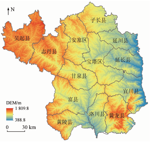
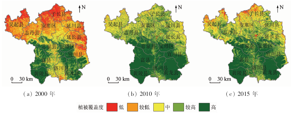
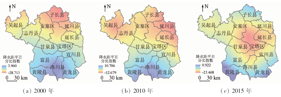
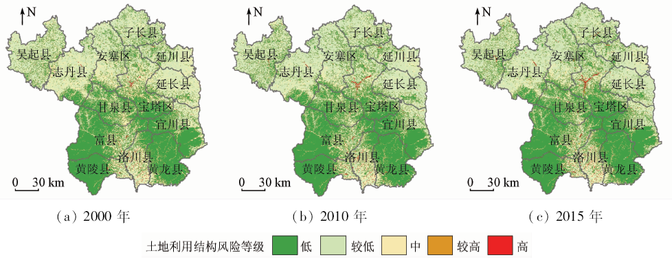
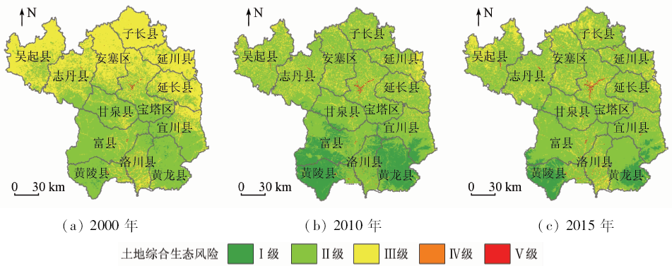
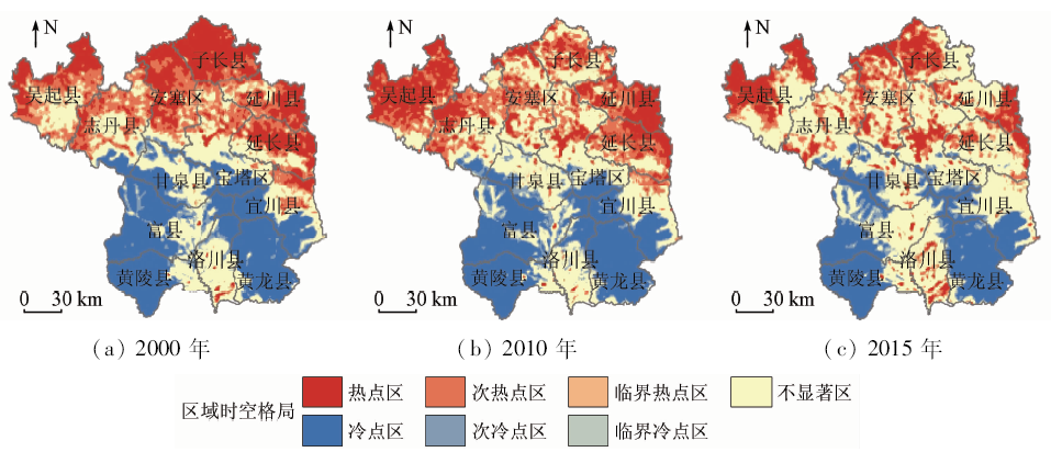
Abstract As a key and demonstration area for the implementation of the national ecological project of returning farmland to forestry, Yan’an City is a concentrated area of ecological problems in China. It is of great significance to study the spatial and temporal differences of land ecological risks for the sustainable development of regional land and the formulation of differentiated land and resources development policies. According to the basic characteristics of land ecosystem, four risk indicators, namely vegetation coverage, percentage anomaly precipitation, land use structure risk index and soil erosion index, were selected to construct a comprehensive evaluation model of land ecological risk. Then on the basis of pixel scale, each factor index and comprehensive index of land ecological risk were calculated. In combination with exploratory spatial data analysis (ESDA), the spatial and temporal evolution of land ecological risk and spatial agglomeration effect in Yan’an City from 2000 to 2015 was analyzed. Then the corresponding suggestions for comprehensive management of land in different regions were put forward. The results are as follows: The land ecology of Yan’an City is in good condition as a whole, whereas the land comprehensive ecological risk and the risk of the four ecological factors temporally decrease on the whole; nevertheless, the area of Baota District and Luochuan County is higher in this aspect, and high comprehensive risk areas increase slightly. The land comprehensive ecological risk of Yan’an City shows a strong spatial agglomeration. Hot spots include urban hot spots located in urban construction areas and northern hot spots distributed in five districts and counties of Zichang County, Ansai District, Yanchuan County, and Wuqi County. The cold points are mainly located in Huanglong County, Yichuan County, Huangling County, Fuxian County and the southwest area of Ganquan County. Thanks to the implementation of national eco-engineering measures such as returning farmland to forestry (grassland) and closing hillsides for reforestation, the agglomeration degree of hot spots has been gradually weakening. However, the area of urban hot spots in Baota District continues to increase, and hence attention should be paid to strengthening ecological management. As cold spot areas in northwest Fuxian and western Yichuan County has been shrinking because of climate drought, attention should be paid to optimizing the allocation of water resources.
|
| Keywords
land ecological risk
exploratory spatial data analysis
spatial agglomeration
Yan’an City
|
|
|
|
Corresponding Authors:
Zhiyuan REN
E-mail: renzhy@snnu.edu.cn
|
|
Issue Date: 14 March 2020
|
|
|
| [1] |
Fan J H, Wang Y, Zhou Z . Dynamic ecological risk assessment and management of land use in the middle reaches of the Heihe River based on landscape patterns and spatial statistics[J]. Sustainability, 2016,8(6):536-551.
|
| [2] |
刘勇, 邢育刚, 李晋昌 . 土地生态风险评价的理论基础及模型构建[J]. 中国土地科学, 2012,26(6):20-25.
|
| [2] |
Liu Y, Xing Y G, Li J C . Theoretical basis and model development for land ecological risk assessment[J]. China Land Sciences, 2012,26(6):20-25.
|
| [3] |
Hunsaker C T, Graham R L, Suter G W , et al. Assessing ecological risk on a regional scale[J]. Environmental Management, 1990,14(3):325-332.
|
| [4] |
陈辉, 刘劲松, 曹宇 , 等. 生态风险评价研究进展[J]. 生态学报, 2006,26(5):1558-1566.
|
| [4] |
Chen H, Liu J S, Cao Y , et al. Progresses of ecological risk assessment[J]. Acta Ecologica Sinica, 2006,26(5):1558-1566.
|
| [5] |
傅伯杰 . 我国生态系统研究的发展趋势与优先领域[J]. 地理研究, 2010,29(3):383-396.
|
| [5] |
Fu B J . Trends and priority areas in ecosystem research of China[J]. Geographical Research, 2010,29(3):383-396.
|
| [6] |
任志远, 刘焱序 . 基于价值量的区域生态安全评价方法探索——以陕北能源区为例[J]. 地理研究, 2013,32(10):1771-1781.
|
| [6] |
Ren Z Y, Liu Y X . Exploring the regional ecological security evaluation methods based on values:A case study in the energy region of northern Shaanxi[J]. Geographical Research, 2013,32(10):1771-1781.
|
| [7] |
臧淑英, 梁欣, 张思冲 . 基于GIS的大庆市土地利用生态风险分析[J]. 自然灾害学报, 2005,14(4):141-145.
|
| [7] |
Zang S Y, Liang X, Zhang S C . GIS-based analysis of ecological risk on land-use in Daqing City[J]. Journal of Natural Disasters, 2005,14(4):141-145.
|
| [8] |
马彩虹 . 陕西黄土台塬区土地生态风险时空差异性评价[J]. 水土保持研究, 2014,21(5):216-220.
|
| [8] |
Ma C H . Assessment on spatio-temporal ecological risk in loess highland region of Shaanxi Province[J]. Research of Soil and Water Conservation, 2014,21(5):216-220.
|
| [9] |
莫宏伟, 任志远 . 风沙过渡区土地生态价值及生态风险动态研究——以陕北神木县为例[J]. 中国沙漠, 2010,30(2):357-362.
|
| [9] |
Mo H W, Ren Z Y . Study on changes of land ecosystem value and ecological risk in sand blowing region:A case study over Shenmu County of Shaanxi Province[J]. Journal of Desert Research, 2010,30(2):357-362.
|
| [10] |
徐兰, 罗维, 周宝同 . 基于土地利用变化的农牧交错带典型流域生态风险评价——以洋河为例[J]. 自然资源学报, 2015,30(4):580-590.
|
| [10] |
Xu L, Luo W, Zhou B T . Landscape ecological risk assessment of farming-pastoral ecozone based on land use change—a case study of the Yanghe Watershed,China[J]. Journal of Natural Resources, 2015,30(4):580-590.
|
| [11] |
周汝佳, 张永战, 何华春 . 基于土地利用变化的盐城海岸带生态风险评价[J]. 地理研究, 2016,35(6):1017-1028.
|
| [11] |
Zhou R J, Zhang Y Z, He H C . Ecological risk assessment based on land use changes in the coastal area in Yancheng City[J]. Geographical Research, 2016,35(6):1017-1028.
|
| [12] |
孙贤斌, 刘红玉 . 江苏盐城市海滨土地利用对景观生态风险的影响[J]. 国土资源遥感, 2011,23(3):140-145.doi: 10.6046/gtzyyg.2011.03.25.
|
| [12] |
Sun X B, Liu H Y . The effect of land use on landscape ecological risk in Yancheng Coastal Area,Jiangsu Province[J]. Remote Sensing for Land and Resources, 2011,23(3):140-145.doi: 10.6046/gtzyyg.2011.03.25.
|
| [13] |
彭文君, 舒英格 . 基于GIS的石漠化山区县域土地利用空间变化的生态风险测度[J]. 水土保持研究, 2018,25(1):342-348,355.
|
| [13] |
Peng W J, Shu Y G . Assessment on ecological risk of land use spatial change at county level in the rocky desertification mountainous area based on GIS[J]. Research of Soil and Water Conservation, 2018,25(1):342-348,355.
|
| [14] |
孙洪波, 杨桂山, 苏伟忠 , 等. 沿江地区土地利用生态风险评价——以长江三角洲南京地区为例[J]. 生态学报, 2010,30(20):5616-5625.
|
| [14] |
Sun H B, Yang G S, Su W Z , et al. Ecological risk assessment of land use in the area along Changjiang River:A case study of Nanjing,China[J]. Acta Ecologica Sinica, 2010,30(20):5616-5625.
|
| [15] |
虞燕娜, 朱江, 吴绍华 , 等. 多风险源驱动下的土地生态风险评价——以江苏省射阳县为例[J]. 自然资源学报, 2016,31(8):1264-1274.
|
| [15] |
Yu Y N, Zhu J, Wu S H , et al. Assessment of land ecological risks driven by multi-sources:A case study of Sheyang County,Jiangsu Province[J]. Journal of Natural Resources, 2016,31(8):1264-1274.
|
| [16] |
王朗, 傅伯杰, 吕一河 , 等. 生态恢复背景下陕北地区植被覆盖的时空变化[J]. 应用生态学报, 2010,21(8):2109-2116.
|
| [16] |
Wang L, Fu B J, Lyu Y H , et al. Spatio-temporal variation of vegetation cover in northern Shaanxi Province under the background of ecological restoration[J]. Chinese Journal of Applied Ecology, 2010,21(8):2109-2116.
|
| [17] |
赵舒怡, 宫兆宁, 刘旭颖 . 2001—2013年华北地区植被覆盖度与干旱条件的相关分析[J]. 地理学报, 2015,70(5):717-729.
|
| [17] |
Zhao S Y, Gong Z N, Liu X Y . Correlation analysis between vegetation coverage and climate drought conditions in North China during 2001—2013[J]. Acta Geographica Sinica, 2015,70(5):717-729.
|
| [18] |
袁文平, 周广胜 . 干旱指标的理论分析与研究展望[J]. 地球科学进展, 2004,19(6):982-991.
|
| [18] |
Yuan W P, Zhou G S . Theoratical study and research prospect on drought indices[J]. Advances in Earth Science, 2004,19(6):982-991.
|
| [19] |
Yu M X, Li Q F, Hayes M J , et al. Are droughts becoming more frequent or severe in China based on the standardized precipitation evapotranspiration index:1951—2010?[J]. International Journal of Climatology, 2014,34(3):545-558.
|
| [20] |
Renard K G, Foster R, Weesies G , et al. Predicting Soil Erosion by Water:A Guide to Conservation Planning with the Revised Universal Soil Loss equation(RUSLE)[M]. Agricultural Handbook.Washington,DC(USA):ARS; 1997.
|
| [21] |
冯强, 赵文武 . USLE/RUSLE中植被覆盖与管理因子研究进展[J]. 生态学报, 2014,34(16):4461-4472.
|
| [21] |
Feng Q, Zhao W W . The study on cover-management factor in USLE and RUSLE:A review[J]. Acta Ecologica Sinica, 2014,34(16):4461-4472.
|
| [22] |
蒋欣阳, 贾志斌, 张雪峰 , 等. 内蒙古锡林郭勒盟景观尺度土壤保持功能的空间分布[J]. 地球环境学报, 2018,9(1):64-78.
|
| [22] |
Jiang X Y, Jia Z B, Zhang X F , et al. Soil conservation function and its spatial distribution of different landscapes in Xilin Gol League,Inner Mongolia[J]. Journal of Earth Environment, 2018,9(1):64-78.
|
| [23] |
张广纳, 邵景安, 王金亮 , 等. 三峡库区重庆段农村面源污染时空格局演变特征[J]. 自然资源学报, 2015,30(7):1197-1209.
|
| [23] |
Zhang G N, Shao J A, Wang J L , et al. Spatial and temporal variations of agricultural non-point source pollution in the Three Gorges Reservoir Area of Chongqing[J]. Journal of Natural Resources, 2015,30(7):1197-1209.
|
| [24] |
马世五, 谢德体, 张孝成 , 等. 三峡库区重庆段土地生态状况时空格局演变特征[J]. 生态学报, 2018,38(23):8512-8525.
|
| [24] |
Ma S W, Xie D T, Zhang X C , et al. Spatiotemporal variation in the ecological status of the Three Gorges Reservoir area in Chongqing,China[J]. Acta Ecologica Sinica, 2018,38(23):8512-8525.
|
| [25] |
韩磊, 朱会利, 刘钊 . 延安市退耕还林前后土地利用动态变化分析[J]. 西北师范大学学报(自然科学版), 2017,53(5):101-108.
|
| [25] |
Han L, Zhu H L, Liu Z . Analysis on land use dynamic changes of pre and post returning farmland to forestland in Yan’an City[J]. Journal of Northwest Normal University(Natural Science), 2017,53(5):101-108.
|
| [26] |
侯孟阳, 姚顺波, 邓元杰 , 等. 格网尺度下延安市生态服务价值时空演变格局与分异特征——基于退耕还林工程的实施背景[J]. 自然资源学报, 2019,34(3):539-552.
|
| [26] |
Hou M Y, Yao S B, Deng Y J , et al. Spatial-temporal evolution pattern and differentiation of ecological service value in Yan’an City at the grid scale based on sloping land conversion program[J]. Journal of Natural Resources, 2019,34(3):539-552.
|
|
Viewed |
|
|
|
Full text
|
|
|
|
|
Abstract
|
|
|
|
|
Cited |
|
|
|
|
| |
Shared |
|
|
|
|
| |
Discussed |
|
|
|
|
 2020,
Vol. 32
2020,
Vol. 32