|
|
|
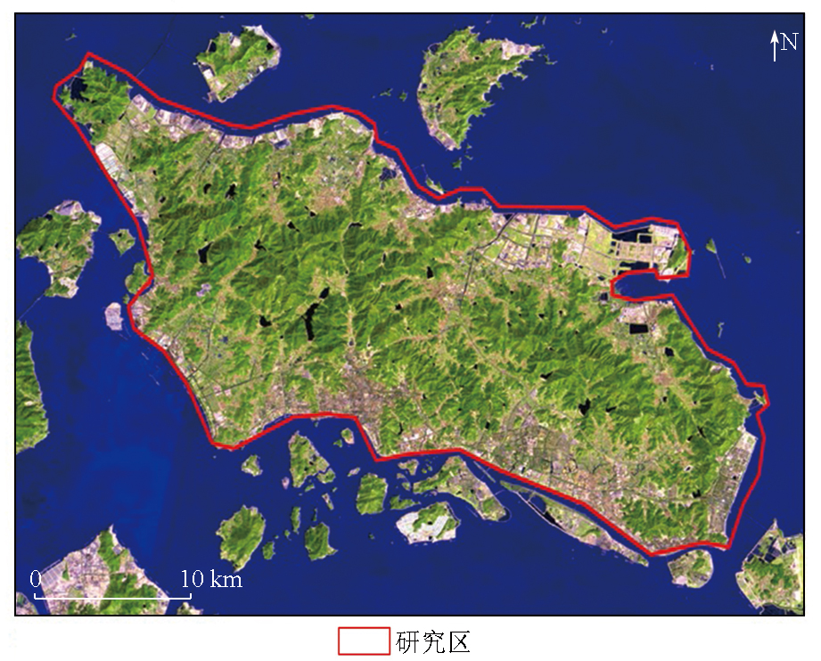
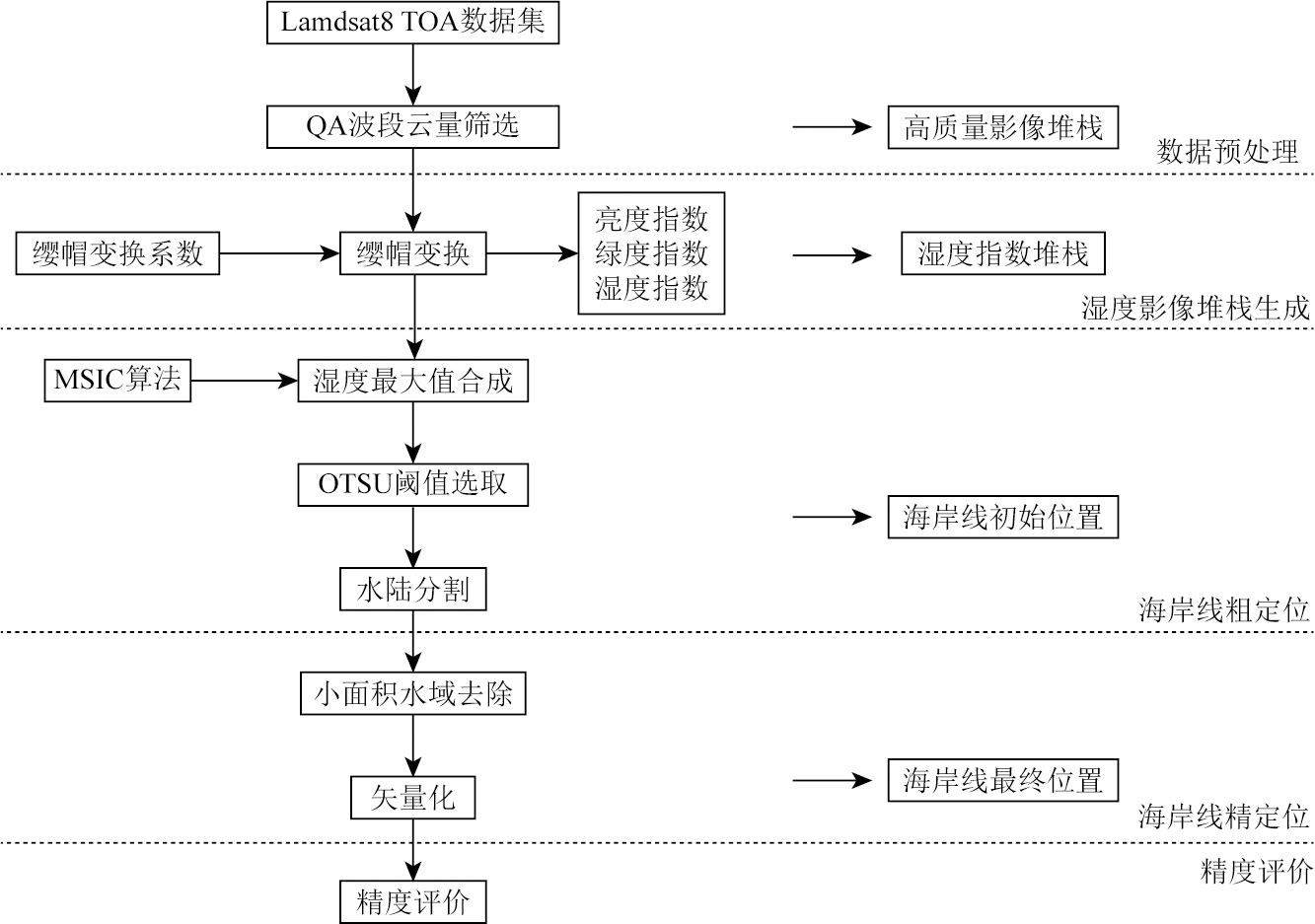
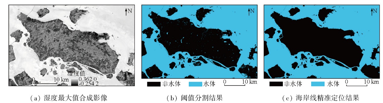
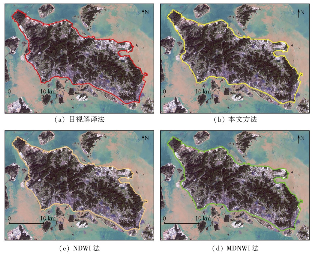
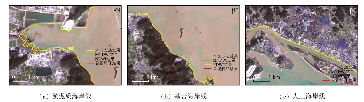
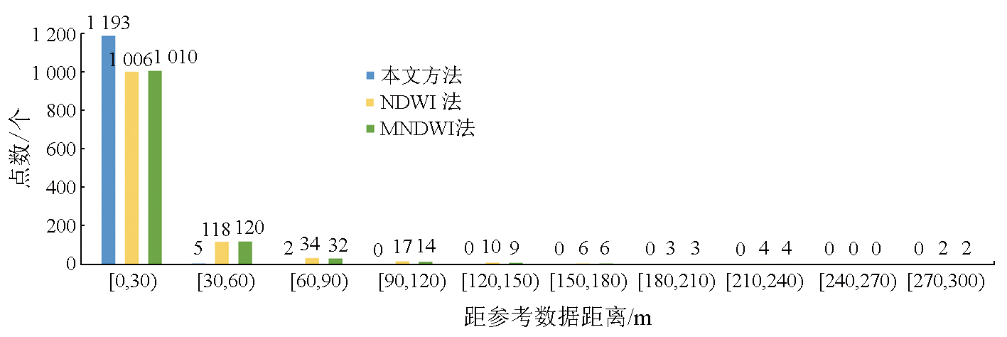
Abstract Coastlines serve as one of the most essential basic geographic elements. However,conventional methods generally face challenges in the accurate detection of their location,due to instantaneous remote sensing imaging and dynamic tidal phenomena. In response to this,this study developed a novel coastline extraction model that incorporates information on surface moisture content derived from long-time-series satellite remote sensing imagery. First,all available remote sensing images covering the study area during the target period were acquired to construct a high-quality remote sensing image stack. Second,the wetness components indicative of the surface moisture content were obtained using the tasseled cap transformation (TCT),from which a wetness index stack was constructed. Then,the wetness components were subjected to maximum value synthesis using the maximum spectral index composite (MSIC) algorithm,generating a maximum water surface composite image. Finally,the composite image was segmented using the OTSU algorithm to extract accurate coastline information. Validation experiments were conducted on Zhoushan Island using the Google Earth Engine (GEE) cloud computing platform and remote sensing imagery from the operational land imager (OLI) onboard the Landsat 8 satellite. The results indicate that the proposed model can precisely locate different types of coastlines with high spatial accuracy. Compared to visual interpretation,the model exhibited a mean deviation and a root mean square error (RMSE) of 3.42 m and 6.79 m,respectively,with 99.42% of validation points falling within one pixel width. This study provides an effective technical framework for high-accuracy coastline extraction,holding great significance for scientific management and sustainable development of coastal resources.
|
| Keywords
coastline
wetness component
tasseled cap transformation (TCT)
long-time-series remote sensing imagery
precise localization
|
|
|
|
Issue Date: 28 October 2025
|
|
|
| [1] |
Boak E H, Turner I L. Shoreline definition and detection:A review[J]. Journal of Coastal Research, 2005, 214:688-703.
|
| [2] |
Kuleli T, Guneroglu A, Karsli F, et al. Automatic detection of shoreline change on coastal Ramsar wetlands of Turkey[J]. Ocean Engineering, 2011, 38(10):1141-1149.
|
| [3] |
侯西勇, 刘静, 宋洋, 等. 中国大陆海岸线开发利用的生态环境影响与政策建议[J]. 中国科学院院刊, 2016, 31(10):1143-1150.
|
| [3] |
Hou X Y, Liu J, Song Y, et al. Environmental-ecological effect of development and utilization of China’s coastline and policy recommendations[J]. Bulletin of Chinese Academy of Sciences, 2016, 31(10):1143-1150.
|
| [4] |
Sun W, Chen C, Liu W, et al. Coastline extraction using remote sensing:A review[J]. GIScience & Remote Sensing, 2023, 60(1):2243671.
|
| [5] |
刘宝银, 苏奋振. 中国海岸带与海岛遥感调查:原则方法系统[M]. 北京: 海洋出版社, 2005.
|
| [5] |
Liu B Y, Su F Z. Remote sensing survey of coastal zones and islands in China:Principles and methods system[M]. Beijing: Ocean Press, 2005.
|
| [6] |
朱琳, 黄玉玲, 杨刚, 等. 基于GEE的杭州湾海岸线遥感提取与时空演变分析[J]. 自然资源遥感, 2023, 35(2):50-60.doi:10.6046/zrzyyg.2022214.
|
| [6] |
Zhu L, Huang Y L, Yang G, et al. Information extraction and spatio-temporal evolution analysis of the coastline in Hangzhou Bay based on Google Earth Engine and remote sensing technology[J]. Remote Sensing for Natural Resources, 2023, 35(2):50-60.doi:10.6046/zrzyyg.2022214.
|
| [7] |
Aiello A, Canora F, Pasquariello G, et al. Shoreline variations and coastal dynamics:A space-time data analysis of the jonian littoral,Italy[J]. Estuarine,Coastal and Shelf Science, 2013, 129:124-135.
|
| [8] |
Dar I A, Dar M A. Prediction of shoreline recession using geospatial technology:A case study of Chennai coast,Tamil Nadu,India[J]. Journal of Coastal Research, 2009, 256:1276-1286.
|
| [9] |
Romine B M, Fletcher C H. A summary of historical shoreline changes on beaches of Kauai,Oahu,and Maui,Hawaii[J]. Journal of Coastal Research, 2013, 288:605-614.
|
| [10] |
Krien Y, Dudon B, Roger J, et al. Assessing storm surge hazard and impact of sea level rise in the Lesser Antilles case study of Martinique[J]. Natural Hazards and Earth System Sciences, 2017, 17(9):1559-1571.
|
| [11] |
Sun C, Li J, Liu Y, et al. Plant species classification in salt marshes using phenological parameters derived from Sentinel-2 pixel-differential time-series[J]. Remote Sensing of Environment, 2021, 256:112320.
|
| [12] |
Hou X, Wu T, Hou W, et al. Characteristics of coastline changes in mainland China since the early 1940s[J]. Science China Earth Sciences, 2016, 59(9):1791-1802.
|
| [13] |
吴一全, 刘忠林. 遥感影像的海岸线自动提取方法研究进展[J]. 遥感学报, 2019, 23(4):582-602.
|
| [13] |
Wu Y Q, Liu Z L. Research progress on methods of automatic coastline extraction based on remote sensing images[J]. Journal of Remote Sensing, 2019, 23(4):582-602.
|
| [14] |
傅姣琪, 陈超, 郭碧云. 缨帽变换的遥感图像水边线信息提取方法[J]. 测绘科学, 2019, 44(5):177-183.
|
| [14] |
Fu J Q, Chen C, Guo B Y. A method of extracting shoreline information from remote sensing image based on tasseled cap transformation[J]. Science of Surveying and Mapping, 2019, 44(5):177-183.
|
| [15] |
李清泉, 卢艺, 胡水波, 等. 海岸带地理环境遥感监测综述[J]. 遥感学报, 2016, 20(5):1216-1229.
|
| [15] |
Li Q Q, Lu Y, Hu S B, et al. Review of remotely sensed geo-environmental monitoring of coastal zones[J]. Journal of Remote Sensing, 2016, 20(5):1216-1229.
|
| [16] |
Sagar S, Roberts D, Bala B, et al. Extracting the intertidal extent and topography of the Australian coastline from a 28 year time series of Landsat observations[J]. Remote Sensing of Environment, 2017, 195:153-169.
|
| [17] |
Chen C, Fu J, Zhang S, et al. Coastline information extraction based on the tasseled cap transformation of Landsat-8 OLI images[J]. Estuarine,Coastal and Shelf Science, 2019, 217:281-291.
|
| [18] |
Bishop-Taylor R, Nanson R, Sagar S, et al. Mapping Australia’s dynamic coastline at mean sea level using three decades of Landsat imagery[J]. Remote Sensing of Environment, 2021, 267:112734.
|
| [19] |
Xu N, Gong P. Significant coastline changes in China during 1991—2015 tracked by Landsat data[J]. Science Bulletin, 2018, 63(14):883-886.
|
| [20] |
Cao W, Zhou Y, Li R, et al. Mapping changes in coastlines and tidal flats in developing islands using the full time series of Landsat images[J]. Remote Sensing of Environment, 2020, 239:111665.
|
| [21] |
Liu C, Xiao Y, Yang J. A coastline detection method in polarimetric SAR images mixing the region-based and edge-based active contour models[J]. IEEE Transactions on Geoscience and Remote Sensing, 2017, 55(7):3735-3747.
|
| [22] |
Li J, Ye M, Pu R, et al. Spatiotemporal change patterns of coastlines in Zhejiang Province,China,over the last twenty-five years[J]. Sustainability, 2018, 10(2):477.
|
| [23] |
陈云浩, 冯通, 史培军, 等. 基于面向对象和规则的遥感影像分类研究[J]. 武汉大学学报(信息科学版), 2006, 31(4):316-320.
|
| [23] |
Chen Y H, Feng T, Shi P J, et al. Classification of remot sensing image based on object oriented and class rules[J]. Geomatics and Information Science of Wuhan University, 2006, 31(4):316-320.
|
| [24] |
詹雅婷, 朱利, 孙永华, 等. 海岸线遥感光谱角度—距离相似度生长模型自动化提取[J]. 遥感学报, 2017, 21(3):458-469.
|
| [24] |
Zhan Y T, Zhu L, Sun Y H, et al. Automatic extraction of coastline via spectral angle-distance similarity growth model[J]. Journal of Remote Sensing, 2017, 21(3):458-469.
|
| [25] |
Dang K B, Dang V B, Ngo V L, et al. Application of deep learning models to detect coastlines and shorelines[J]. Journal of Environmental Management, 2022, 320:115732.
|
| [26] |
Sun S, Mu L, Feng R, et al. Quadtree decomposition-based Deep learning method for multiscale coastline extraction with high-resolution remote sensing imagery[J]. Science of Remote Sensing, 2024, 9:100112.
|
| [27] |
Wei Z, Jiao X, Du Y, et al. The temporal variations in principal and shallow-water tidal constituents and their application in tidal level calculation:An example in Zhoushan archipelagoes with complex bathymetry[J]. Ocean and Coastal Management, 2023, 237:106516.
|
| [28] |
Chen C, Liang J, Xie F, et al. Temporal and spatial variation of coastline using remote sensing images for Zhoushan Archipelago,China[J]. International Journal of Applied Earth Observation and Geoinformation, 2022, 107:102711.
|
| [29] |
Gorelick N, Hancher M, Dixon M, et al. Google Earth Engine:Planetary-scale geospatial analysis for everyone[J]. Remote Sensing of Environment, 2017, 202:18-27.
|
| [30] |
Mao Y, Harris D L, Xie Z, et al. Efficient measurement of large-scale decadal shoreline change with increased accuracy in tide-dominated coastal environments with Google Earth Engine[J]. ISPRS Journal of Photogrammetry and Remote Sensing, 2021, 181:385-399.
|
| [31] |
Mateo-García G, Gómez-Chova L, Amorós-López J, et al. Multitemporal cloud masking in the Google Earth Engine[J]. Remote Sensing, 2018, 10(7):1079.
|
| [32] |
Liu Y, Liu Y, Li J, et al. Trajectory of coastal wetland vegetation in Xiangshan Bay,China,from image time series[J]. Marine Pollution Bulletin, 2020, 160:111697.
|
| [33] |
Guo R, Zhu X, Zhang C, et al. Analysis of change in maize plantation distribution and its driving factors in Heilongjiang Province,China[J]. Remote Sensing, 2022, 14(15):3590.
|
| [34] |
Kauth R J, Thomas G S. The tasselled cap: A graphic description of the spectral-temporal development of agricultural crops as seen by Landsat[C]// LARS symposia.1976:159.
|
| [35] |
Pelletier N, Millard K, Darling S. Wildfire likelihood in Canadian treed peatlands based on remote-sensing time-series of surface conditions[J]. Remote Sensing of Environment, 2023, 296:113747.
|
| [36] |
Crist E P. A TM Tasseled cap equivalent transformation for reflectance factor data[J]. Remote Sensing of Environment, 1985, 17(3):301-306.
|
| [37] |
闫柏琨, 甘甫平, 印萍, 等. 1989—2021年中国大陆海岸带潮滩、海岸线、养殖水体遥感观测[J]. 自然资源遥感, 2023, 35(3):53-63.doi:10.6046/zrzyyg.2022471.
|
| [37] |
Yan B K, Gan F P, Yin P, et al. Remote sensing observations of tidal flats,shorelines,and aquacultural water bodies along coastal zones in China mainland during 1989—2021[J]. Remote Sensing for Natural Resources, 2023, 35(3):53-63.doi:10.6046/zrzyyg.2022471.
|
| [38] |
Ali Baig M H, Zhang L, Shuai T, et al. Derivation of a tasselled cap transformation based on Landsat 8 at-satellite reflectance[J]. Remote Sensing Letters, 2014, 5(5):423-431.
|
| [39] |
Jia M, Wang Z, Mao D, et al. Rapid,robust,and automated mapping of tidal flats in China using time series Sentinel-2 images and Google Earth Engine[J]. Remote Sensing of Environment, 2021, 255:112285.
|
| [40] |
程丽娜, 钟才荣, 李晓燕, 等. Sentinel-2密集时间序列数据和Google Earth Engine的潮间带湿地快速自动分类[J]. 遥感学报, 2022, 26(2):348-357.
|
| [40] |
Cheng L N, Zhong C R, Li X Y, et al. Rapid and automatic classification of intertidal wetlands based on intensive time series Sentinel-2 images and Google Earth Engine[J]. National Remote Sensing Bulletin, 2022, 26(2):348-357.
|
|
Viewed |
|
|
|
Full text
|
|
|
|
|
Abstract
|
|
|
|
|
Cited |
|
|
|
|
| |
Shared |
|
|
|
|
| |
Discussed |
|
|
|
|
 2025,
Vol. 37
2025,
Vol. 37
 ), CHEN Chao2(