|
|
 |
|

|
|
|
Information extraction and spatio-temporal evolution analysis of the coastline in Hangzhou Bay based on Google Earth Engine and remote sensing technology |
ZHU Lin1( ), HUANG Yuling1, YANG Gang1(), SUN Weiwei1, CHEN Chao2, HUANG Ke1 ), HUANG Yuling1, YANG Gang1(), SUN Weiwei1, CHEN Chao2, HUANG Ke1 |
1. Department of Geography and Spatial Information Techniques, Ningbo University, Ningbo 315211, China
2. School of Geography Science and Geomatics Engineering, Suzhou University of Science and Technology, Suzhou 215009, China |
|
|
|
|
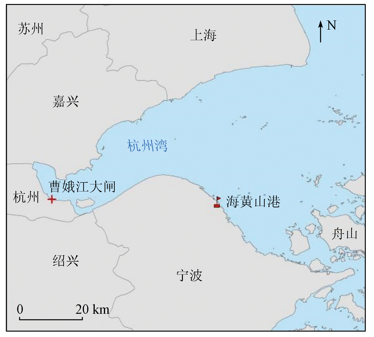
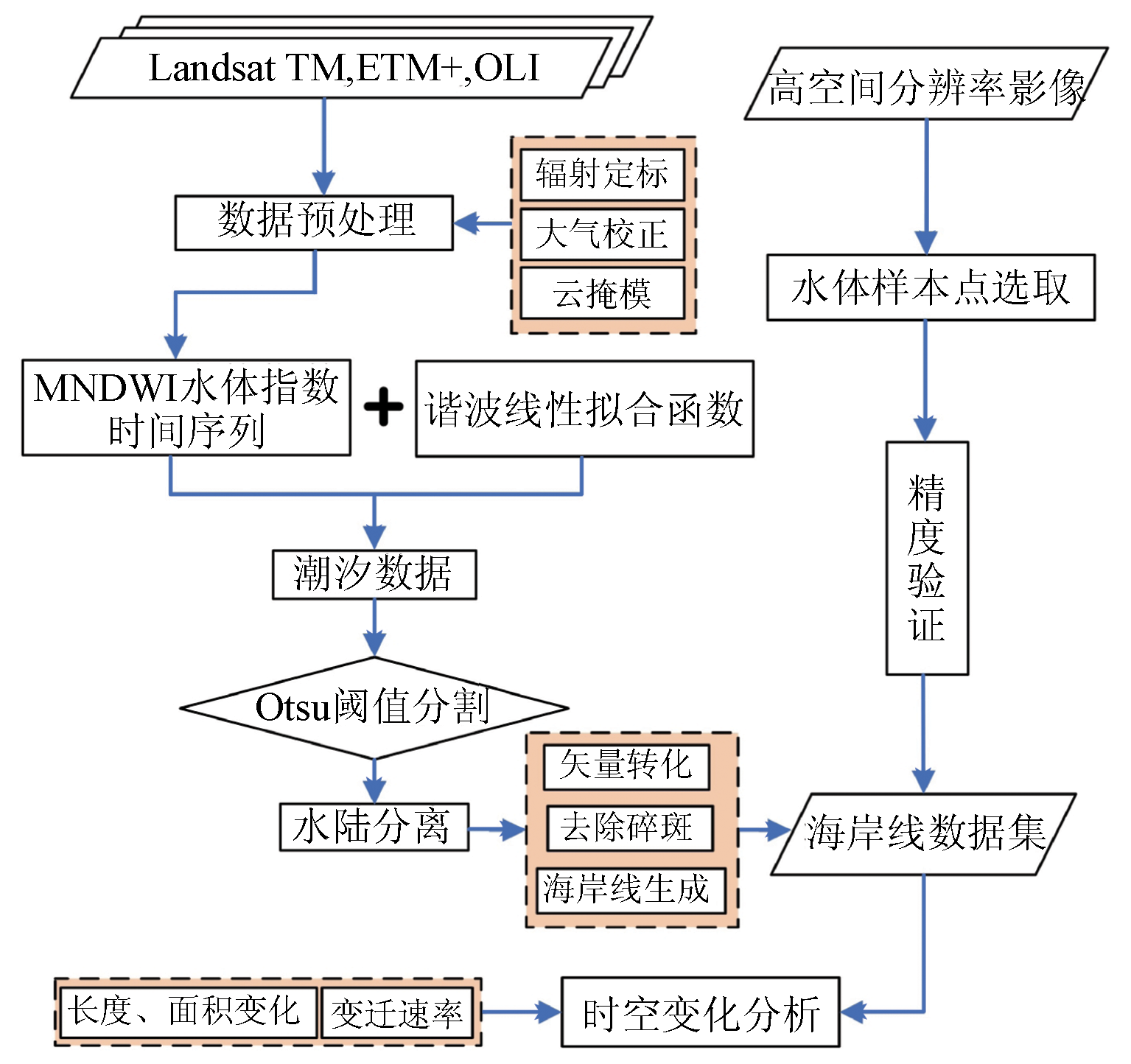
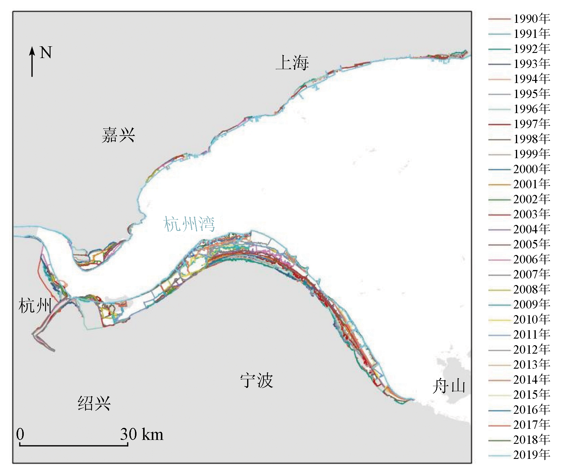
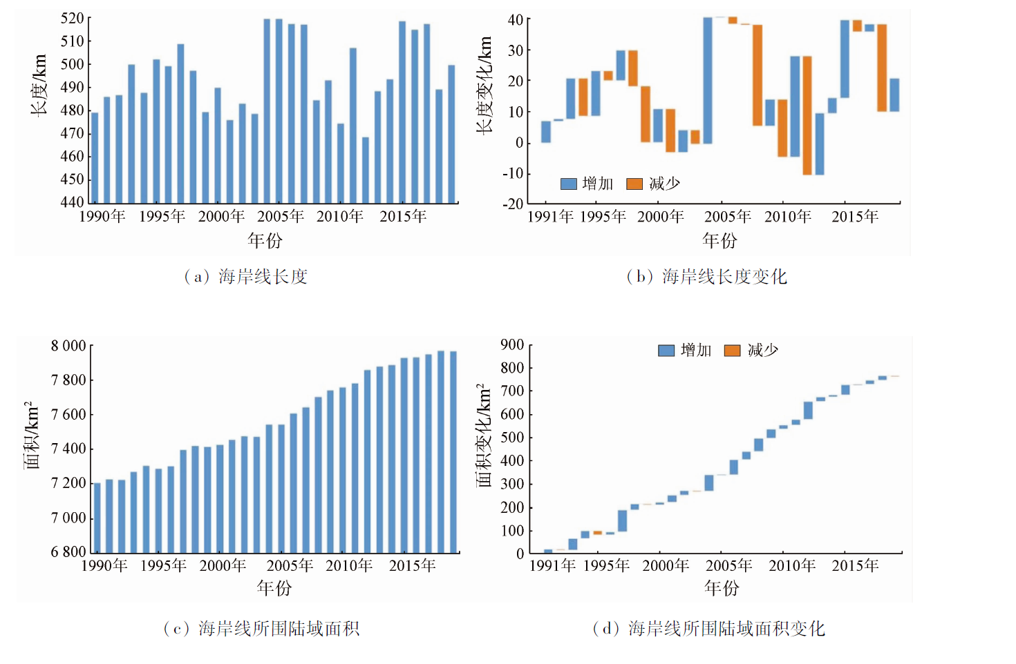
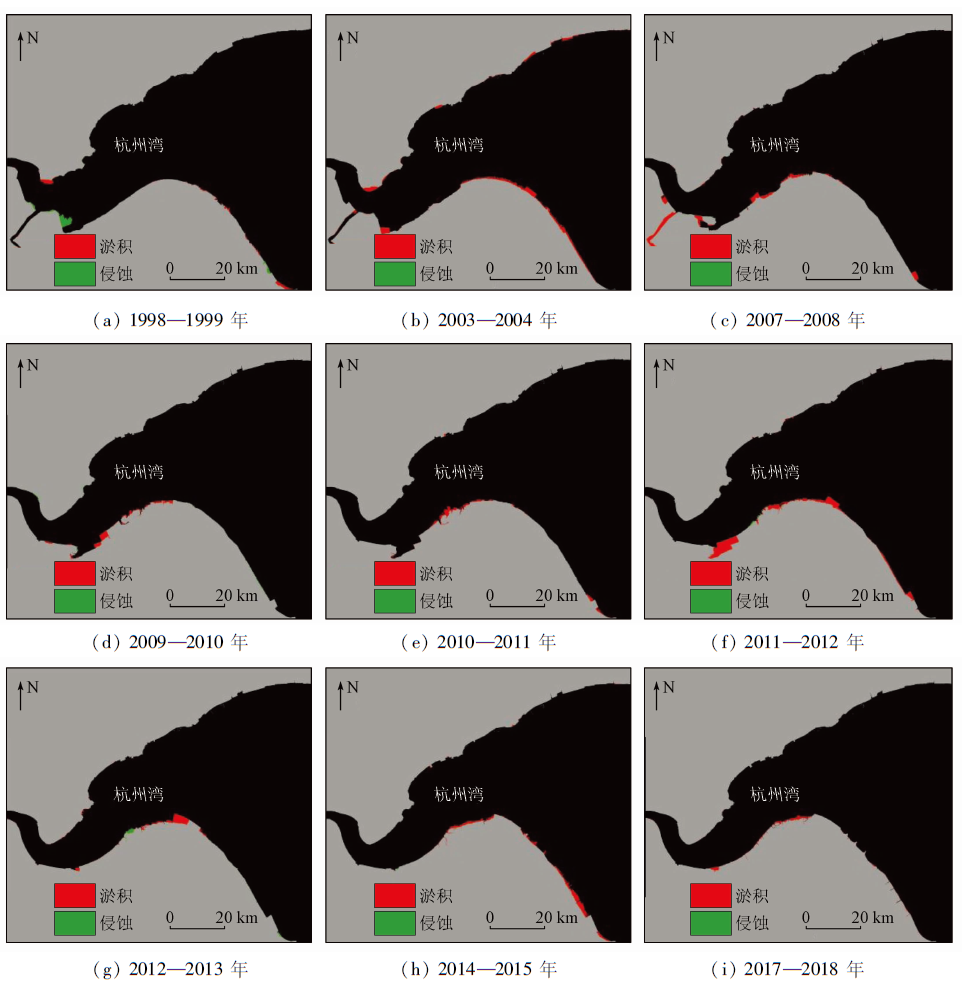
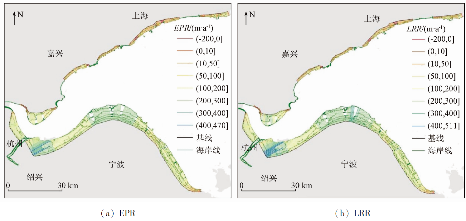
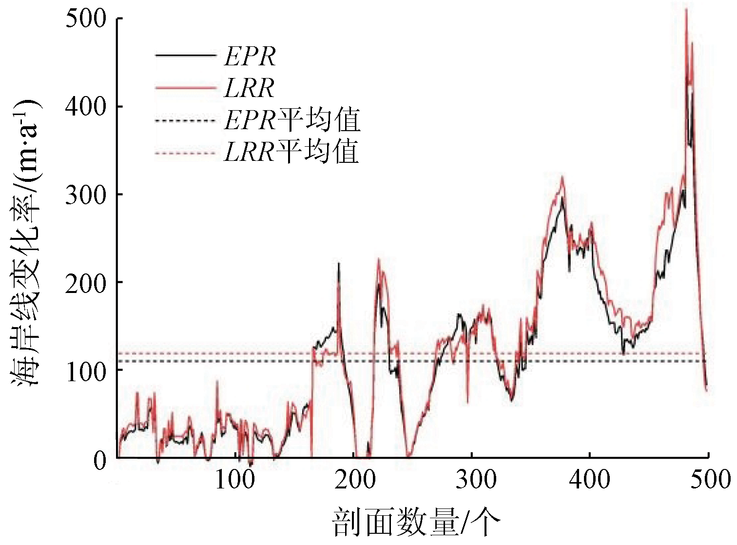
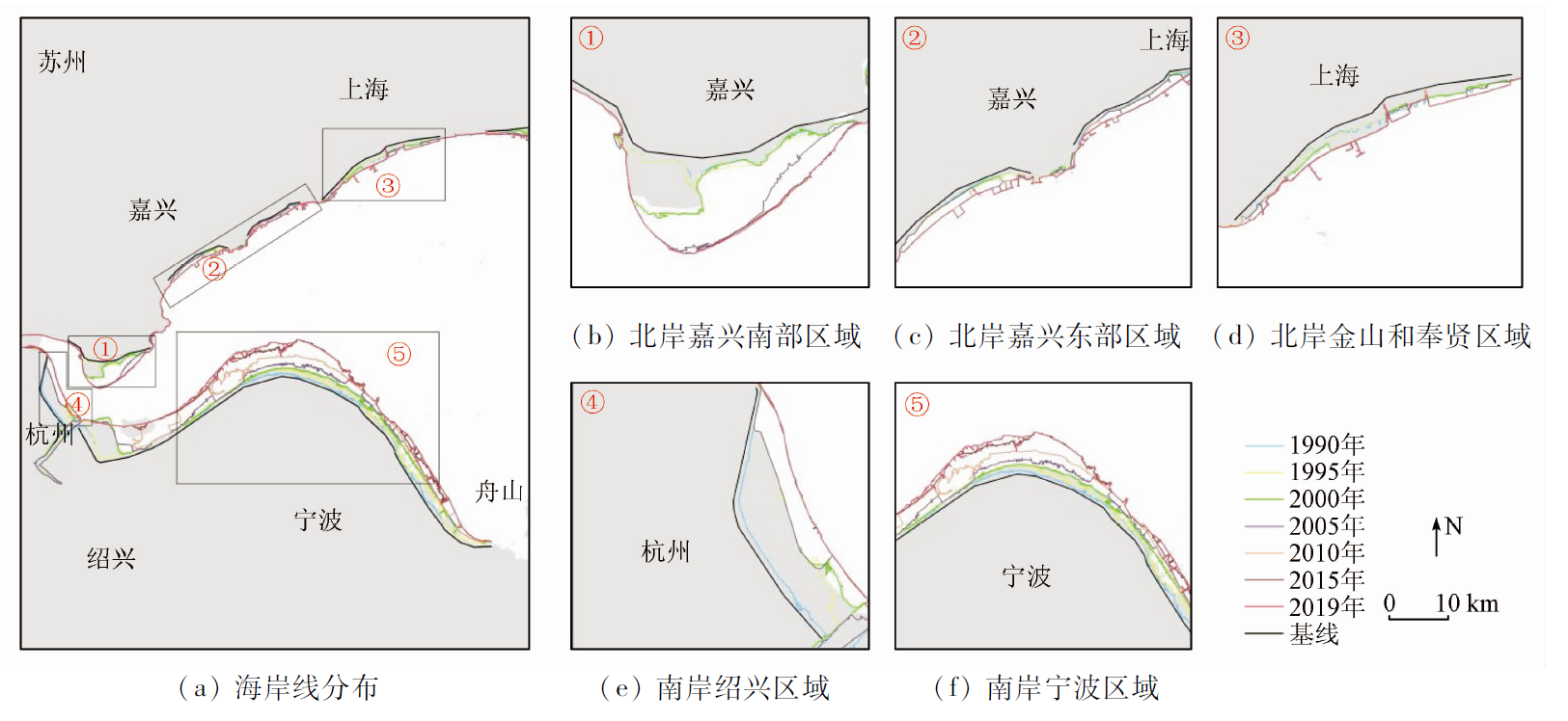
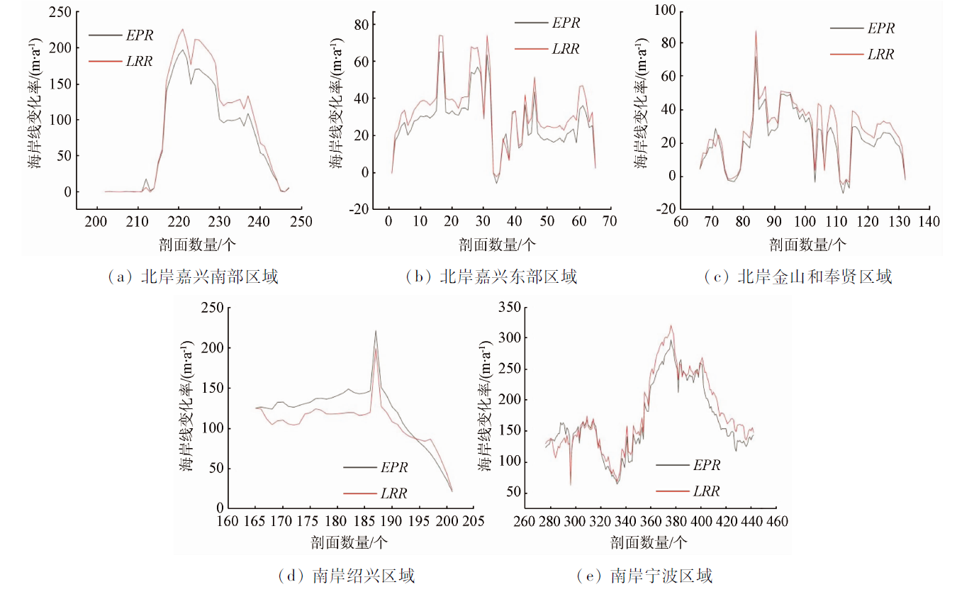
Abstract The continuous monitoring of the dynamic changes in coastlines is crucial to ascertaining the change patterns and evolution characteristics of coastlines. Long-time-series coastline datasets allow for the detailed description of the dynamic changes in coastlines from the spatio-temporal dimensions and further reflect the effects of human activities and natural factors on coastal areas. Therefore, they are conducive to the scientific management and sustainable development of the spatial resources in coastal wetlands. Based on the Google Earth Engine (GEE), this study analyzed the change in the coastline of Hangzhou Bay during 1990—2019 based on long-time-series Landsat TM/ETM+/OLI images. Using the pixel-level modified normalized difference water index (MNDWI) time series reconstruction technology, this study achieved the automatic information extraction of long-time-series coastlines and the analysis of spatio-temporal changes by combining the Otsu algorithm threshold segmentation and the Digital Shoreline Analysis System. The results show that the total coastline length of Hangzhou Bay increased by about 20.69 km during 1990—2019, corresponding to an increase in the land area by about 764.81 km2, with an average annual increase rate of 0.35%. In addition, the average end point rate (EPR) and linear regression rate (LRR) of the coastline were 110.07 m/a and 119.06 m/a, respectively. The analysis of the spatio-temporal evolution of the coastline in Hangzhou Bay over 30 years will provide a basis for the sustainable development and comprehensive management of resources along the coastline in Hangzhou Bay.
|
| Keywords
coastline
Hangzhou Bay
Google Earth Engine
spatio-temporal evolution
|
|
|
|
Issue Date: 07 July 2023
|
|
|
| [1] |
Kuleli T, Guneroglu A, Karsli F, et al. Automatic detection of shoreline change on coastal Ramsar wetlands of Turkey[J]. Ocean Engineering, 2011, 38(10):1141-1149.
doi: 10.1016/j.oceaneng.2011.05.006
url: https://linkinghub.elsevier.com/retrieve/pii/S0029801811000874
|
| [2] |
Li J, Ye M, Pu R, et al. Spatiotemporal change patterns of coastlines in Zhejiang Province,China,over the last twenty-five years[J]. Sustainability, 2018, 10(2):477.
doi: 10.3390/su10020477
url: http://www.mdpi.com/2071-1050/10/2/477
|
| [3] |
Sui L, Wang J, Yang X, et al. Spatial-temporal characteristics of coastline changes in Indonesia from 1990 to 2018[J]. Sustainability, 2020, 12(8):3242.
doi: 10.3390/su12083242
url: https://www.mdpi.com/2071-1050/12/8/3242
|
| [4] |
Liu L, Xu W, Yue Q, et al. Problems and countermeasures of coastline protection and utilization in China[J]. Ocean and Coastal Management, 2018, 153:124-130.
doi: 10.1016/j.ocecoaman.2017.12.016
url: https://linkinghub.elsevier.com/retrieve/pii/S0964569117305306
|
| [5] |
梁立, 刘庆生, 刘高焕, 等. 基于遥感影像的海岸线提取方法综述[J]. 地球信息科学学报, 2018, 20(12):1745-1755.
doi: 10.12082/dqxxkx.2018.180152
|
| [5] |
Liang L, Liu Q S, Liu G H, et al. Review of coastline extraction methods based on remote sensing images[J]. Journal of Geo-Information Science, 2018, 20(12):1745-1755.
|
| [6] |
毋亭, 侯西勇. 海岸线变化研究综述[J]. 生态学报, 2016, 36(4):1170-1182.
|
| [6] |
Wu T, Hou X Y. Review of research on coastline changes[J]. Acta Ecologica Sinica, 2016, 36(4):1170-1182.
|
| [7] |
吴一全, 刘忠林. 遥感影像的海岸线自动提取方法研究进展[J]. 遥感学报, 2019, 23(4):582-602.
|
| [7] |
Wu Y Q, Liu Z L. Research progress on methods of automatic coastline extraction based on remote sensing images[J]. Journal of Remote Sensing, 2019, 23(4):582-602.
|
| [8] |
Toure S, Diop O, Kpalma K, et al. Shoreline detection using optical remote sensing:A review[J]. ISPRS International Journal of Geo-Information, 2019, 8(2):75.
doi: 10.3390/ijgi8020075
url: http://www.mdpi.com/2220-9964/8/2/75
|
| [9] |
高义, 王辉, 苏奋振, 等. 中国大陆海岸线近30 a的时空变化分析[J]. 海洋学报, 2013, 35(6):31-42.
|
| [9] |
Gao Y, Wang H, Su F Z, et al. Spatial and temporal of continental coastline of China in recent three decades[J]. Acta Oceanologica Sinica, 2013, 35(6):31-42.
|
| [10] |
陈超, 陈慧欣, 陈东, 等. 舟山群岛海岸线遥感信息提取及时空演变分析[J]. 国土资源遥感, 2021, 33(2):141-152.doi:10.6046/gtzyyg.2020248.
doi: 10.6046/gtzyyg.2020248
|
| [10] |
Chen C, Chen H X, Chen D, et al. Coastline extraction and spatial-temporal variations using remote sensing technology in Zhoushan Islands[J]. Remote Sensing for Land and Resources, 2021, 33(2):141-152.doi:10.6046/gtzyyg.2020248.
doi: 10.6046/gtzyyg.2020248
|
| [11] |
Wang D. Remote sensing of the coastline variation of the Guangdong-Hongkong-Macao Greater Bay Area in the past four decades[J]. Journal of Marine Science and Engineering, 2021, 9(12):1318.
doi: 10.3390/jmse9121318
url: https://www.mdpi.com/2077-1312/9/12/1318
|
| [12] |
Vos K, Harley M D, Splinter K D, et al. Sub-annual to multi-decadal shoreline variability from publicly available satellite imagery[J]. Coastal Engineering, 2019, 150:160-174.
doi: 10.1016/j.coastaleng.2019.04.004
url: https://linkinghub.elsevier.com/retrieve/pii/S0378383918305313
|
| [13] |
Wei X, Zheng W, Xi C, et al. Shoreline extraction in SAR image based on advanced geometric active contour model[J]. Remote Sensing, 2021, 13(4):642.
doi: 10.3390/rs13040642
url: https://www.mdpi.com/2072-4292/13/4/642
|
| [14] |
Sagar S, Roberts D, Bala B, et al. Extracting the intertidal extent and topography of the Australian coastline from a 28 year time series of Landsat observations[J]. Remote Sensing of Environment, 2017, 195:153-169.
doi: 10.1016/j.rse.2017.04.009
url: https://linkinghub.elsevier.com/retrieve/pii/S0034425717301591
|
| [15] |
Sekovski I, Stecchi F, Mancini F, et al. Image classification metho-ds applied to shoreline extraction on very high-resolution multispectral imagery[J]. International Journal of Remote Sensing, 2014, 35(10):3556-3578.
doi: 10.1080/01431161.2014.907939
url: https://www.tandfonline.com/doi/full/10.1080/01431161.2014.907939
|
| [16] |
Nguyen H Q, Takewaka S. Shoreline changes along northern Ibaraki coast after the great East Japan Earthquake of 2011[J]. Remote Sensing, 2021, 13(7):1399.
doi: 10.3390/rs13071399
url: https://www.mdpi.com/2072-4292/13/7/1399
|
| [17] |
Donchyts G, van de Giesen N, Gorelick N. Reconstruction of reservoir and lake surface area dynamics from optical and SAR satellite imagery[C]// International Workshop on the Analysis of Multitemporal Remote Sensing Images, 2017.
|
| [18] |
Canny J. A computational approach to edge detection[J]. IEEE Transactions on Pattern Analysis and Machine Intelligence, 1986 (6):679-698.
pmid: 21869365
|
| [19] |
Dai C, Howat I M, Larour E, et al. Coastline extraction from repeat high resolution satellite imagery[J]. Remote Sensing of Environment, 2019, 229:260-270.
doi: 10.1016/j.rse.2019.04.010
|
| [20] |
Xu N. Detecting coastline change with all available Landsat data over 1986—2015:A case study for the state of Texas,USA[J]. Atmosphere, 2018, 9(3):107.
doi: 10.3390/atmos9030107
url: http://www.mdpi.com/2073-4433/9/3/107
|
| [21] |
Jiang W, Ni Y, Pang Z, et al. An effective water body extraction method with new water index for Sentinel-2 imagery[J]. Water, 2021, 13(12):1647.
doi: 10.3390/w13121647
url: https://www.mdpi.com/2073-4441/13/12/1647
|
| [22] |
Bishop-Taylor R, Nanson R, Sagar S, et al. Mapping Australia’s dynamic coastline at mean sea level using three decades of Landsat imagery[J]. Remote Sensing of Environment, 2021, 267:112734.
doi: 10.1016/j.rse.2021.112734
url: https://linkinghub.elsevier.com/retrieve/pii/S0034425721004545
|
| [23] |
Ghosh M K, Kumar L, Roy C. Monitoring the coastline change of Hatiya Island in Bangladesh using remote sensing techniques[J]. ISPRS Journal of Photogrammetry and Remote Sensing, 2015, 101:137-144.
doi: 10.1016/j.isprsjprs.2014.12.009
url: https://linkinghub.elsevier.com/retrieve/pii/S0924271614002846
|
| [24] |
Cao W, Zhou Y, Li R, et al. Mapping changes in coastlines and tidal flats in developing islands using the full time series of Landsat images[J]. Remote Sensing of Environment, 2020, 239:111665.
doi: 10.1016/j.rse.2020.111665
url: https://linkinghub.elsevier.com/retrieve/pii/S0034425720300341
|
| [25] |
Guo Q. Bangladesh shoreline changes during the last four decades using satellite remote sensing data[D]. Columbus: The Ohio State University, 2017.
|
| [26] |
Chunye W, Delu P. Zoning of Hangzhou Bay ecological red line using GIS-based multi-criteria decision analysis[J]. Ocean and Coastal Management, 2017, 139:42-50.
doi: 10.1016/j.ocecoaman.2017.01.013
url: https://linkinghub.elsevier.com/retrieve/pii/S0964569117300352
|
| [27] |
Chu L, Oloo F, Sudmanns M, et al. Monitoring longterm shoreline dynamics and human activities in the Hangzhou Bay,China,combining daytime and nighttime EO data[J]. Big Earth Data, 2020, 4(3):242-264.
doi: 10.1080/20964471.2020.1740491
url: https://www.tandfonline.com/doi/full/10.1080/20964471.2020.1740491
|
| [28] |
Wang X, Liu Y, Ling F, et al. Spatiotemporal change detection of Ningbo coastline using Landsat time-series images during 1976—2015[J]. ISPRS International Journal of Geo-Information, 2017, 6(3):68.
doi: 10.3390/ijgi6030068
url: http://www.mdpi.com/2220-9964/6/3/68
|
| [29] |
贾明明, 刘殿伟, 王宗明, 等. 面向对象方法和多源遥感数据的杭州湾海岸线提取分析[J]. 地球信息科学学报, 2013, 15(2):262-269.
doi: 10.3724/SP.J.1047.2013.00262
|
| [29] |
Jia M M, Liu D W, Wang Z M, et al. Coastline changes in Hangzhou Bay based on object-oriented method using multi-source remote sensing data[J]. Journal of Geo-Information Science, 2013, 15(2):262-269.
doi: 10.3724/SP.J.1047.2013.001262
url: http://www.dqxxkx.cn/CN/10.3724/SP.J.1047.2013.001262
|
| [30] |
Qiu L, Zhang M, Zhou B, et al. Economic and ecological trade-offs of coastal reclamation in the Hangzhou Bay,China[J]. Ecological Indicators, 2021, 125:107477.
doi: 10.1016/j.ecolind.2021.107477
url: https://linkinghub.elsevier.com/retrieve/pii/S1470160X21001424
|
| [31] |
Zhou Y, Dong J, Xiao X, et al. Continuous monitoring of lake dynamics on the Mongolian Plateau using all available Landsat imagery and Google Earth Engine[J]. Science of the Total Environment, 2019, 689:366-380.
doi: 10.1016/j.scitotenv.2019.06.341
|
| [32] |
Gorelick N, Hancher M, Dixon M, et al. Google Earth Engine:Planetary-scale geospatial analysis for everyone[J]. Remote Sensing of Environment, 2017, 202:18-27
doi: 10.1016/j.rse.2017.06.031
url: https://linkinghub.elsevier.com/retrieve/pii/S0034425717302900
|
| [33] |
徐涵秋. 利用改进的归一化差异水体指数 (MNDWI) 提取水体信息的研究[J]. 遥感学报, 2005, 9(5):589-595.
|
| [33] |
Xu H Q. A study on information extraction of water body with the modified normalized difference water index (MNDWI)[J]. Journal of Remote Sensing, 2005, 9(5):589-595.
|
| [34] |
Zhou J, Jia L, Menenti M. Reconstruction of global MODIS NDVI time series:Performance of harmonic analysis of time series (HANTS)[J]. Remote Sensing of Environment, 2015, 163:217-228.
doi: 10.1016/j.rse.2015.03.018
url: https://linkinghub.elsevier.com/retrieve/pii/S0034425715001145
|
| [35] |
Otsu N. A threshold selection method from gray-level histograms[J]. IEEE Transactions on Systems,Man,and Cybernetics, 1979, 9(1):62-66.
doi: 10.1109/TSMC.1979.4310076
url: http://ieeexplore.ieee.org/document/4310076/
|
| [36] |
Nausheen N, Seal A, Khanna P, et al. A FPGA based implementation of Sobel edge detection[J]. Microprocessors and Microsystems, 2018, 56:84-91.
doi: 10.1016/j.micpro.2017.10.011
url: https://linkinghub.elsevier.com/retrieve/pii/S0141933116302289
|
| [37] |
Himmelstoss E A, Henderson R E, Kratzmann M G, et al. Digital Shoreline Analysis System (DSAS) version 5.0 user guide[R]. U.S.Department of the Interior: U.S.Geological Survey, 2018.
|
| [38] |
Zhu Q, Li P, Li Z, et al. Spatiotemporal changes of coastline over the Yellow River Delta in the previous 40 years with optical and SAR remote sensing[J]. Remote Sensing, 2021, 13(10):1940.
doi: 10.3390/rs13101940
url: https://www.mdpi.com/2072-4292/13/10/1940
|
| [39] |
丁小松, 单秀娟, 陈云龙, 等. 基于数字化海岸分析系统(DSAS)的海岸线变迁速率研究:以黄河三角洲和莱州湾海岸线为例[J]. 海洋通报, 2018, 37(5):565-575.
|
| [39] |
Ding X S, Shan X J, Chen Y L, et al. Study on the change rate of shoreline based on Digital Coastal Analysis System (DSAS):Taking the shoreline of the Yellow River Delta and Laizhou Bay as an example[J]. Marine Science Bulletin, 2018, 37(5):565-575.
|
| [40] |
谢东风, 高抒, 潘存鸿, 等. 杭州湾沉积物宏观输运的数值模拟[J]. 泥沙研究, 2012(3):51-56.
|
| [40] |
Xie D F, Gao S, Pan C H, et al. Modelling macroscale suspended sediment transport patterns in Hangzhou Bay,China[J]. Journal of Sediment Research, 2012(3):51-56.
|
| [41] |
Xie D, Gao S, Wang Z B, et al. Morphodynamic modeling of a large inside sand bar and its dextral morphology in a convergent estuary:Qiantang Estuary,China[J]. Journal of Geophysical Research, 2017, 122(8):1553-1572.
|
| [42] |
胡成飞, 潘存鸿, 吴修广, 等. 1959—2019年杭州湾南岸滩涂演变规律及机制[J]. 水科学进展, 2021, 32(2):230-241.
|
| [42] |
Hu C F, Pan C H, Wu X G, et al. Evolution law and mechanism of tidal flats on the south bank of Hangzhou Bay from 1959 to 2019[J]. Advances in Water Science, 2021, 32(2):230-241.
|
| [43] |
Chaudhry M H. Open-channel flow[M]. New York: Springer, 2008.
|
| [44] |
Jilan S, Kangshan W. Changjiang River plume and suspended sediment transport in Hangzhou Bay[J]. Continental Shelf Research, 1989, 9(1):93-111.
doi: 10.1016/0278-4343(89)90085-X
url: https://linkinghub.elsevier.com/retrieve/pii/027843438990085X
|
| [45] |
Xie D, Pan C, Wu X, et al. The variations of sediment transport patterns in the outer Changjiang Estuary and Hangzhou Bay over the last 30 years[J]. Journal of Geophysical Research:Oceans, 2017, 122(4):2999-3020.
doi: 10.1002/2016JC012264
url: http://doi.wiley.com/10.1002/2016JC012264
|
| [46] |
叶翔, 王爱军, 马牧, 等. 高强度人类活动对泉州湾滨海湿地环境的影响及其对策[J]. 海洋科学, 2016, 40(1):94-100.
|
| [46] |
Ye X, Wang A J, Ma M, et al. Effects of high-intensity human activities on the environment variations of coastal wetland in the Quanzhou Bay,China[J]. Marine Sciences, 2016, 40(1):94-100.
|
| [47] |
Shahtahmassebi A R, Wu C, Blackburn G A, et al. How do modern transportation projects impact on development of impervious surfaces via new urban area and urban intensification? Evidence from Hangzhou Bay Bridge,China[J]. Land Use Policy, 2018, 77:479-497.
doi: 10.1016/j.landusepol.2018.05.059
url: https://linkinghub.elsevier.com/retrieve/pii/S0264837716305701
|
| [48] |
Tian P, Li J, Cao L, et al. Impacts of reclamation derived land use changes on ecosystem services in a typical gulf of eastern China:A case study of Hangzhou bay[J]. Ecological Indicators, 2021, 132:108259.
doi: 10.1016/j.ecolind.2021.108259
url: https://linkinghub.elsevier.com/retrieve/pii/S1470160X21009249
|
|
Viewed |
|
|
|
Full text
|
|
|
|
|
Abstract
|
|
|
|
|
Cited |
|
|
|
|
| |
Shared |
|
|
|
|
| |
Discussed |
|
|
|
|
 2023,
Vol. 35
2023,
Vol. 35