|
|
 |
|

|
|
|
Application of local spatial autocorrelation indices to the delimitation of urban heat island |
Zhenlan JIANG1, Zhenbin GONG2, Hui PAN3( ), Baoyu ZHANG1, Tingfen WANG1 ), Baoyu ZHANG1, Tingfen WANG1 |
1. Department of Geographical Science, Minjiang University, Fuzhou 350108, China
2. Fuzhou Meterorological Service, Fuzhou 350008, China
3. Minjiang University, Fuzhou 350108, China |
|
|
|
|
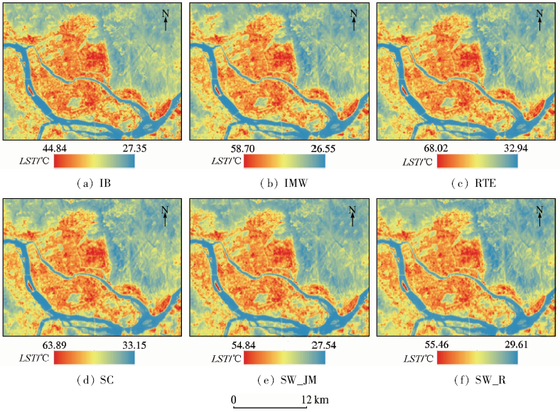
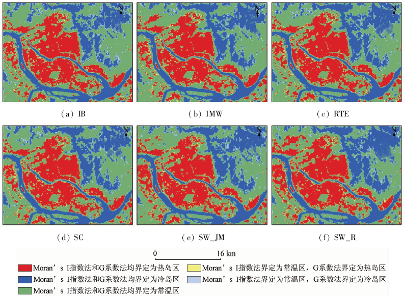
Abstract In this paper, two spatial autocorrelation indices were used to delimit urban heat island in Fuzhou City in a statistical sense. The effectiveness and limitation of the two indices were then analyzed so as to find effective methods for quantitative study of urban heat island. At first, land surface temperature (LST) was retrieved on the basis of Landsat8 thermal infrared data of Fuzhou City by applying 6 methods that are frequently used. Then Local Moran’s I Index and Getis-Ord local G were used to delimit urban heat island in the study area. At last the different delimitation outcomes were compared with each other and were then compared with the outcomes obtained by other methods, including equal interval method, mean standard deviation method and regional average classification method. The findings are as follows: ① Both Local Moran’s I index and Getis-Ord local G accurately delimit urban heat island. By comparison, Getis-Ord local G is more accurate in heat island delimitation and is less dependent on methods of LST retrieval. It is more comparable with other heat island delimitation methods; ② The method applying Getis-Ord local G takes into account both surface temperature and spatial correlation of temperature, which makes the delimitation outcome statistically meaningful. With its threshold value free of human factors, the method is therefore more objective and more applicable in the quantitative study of urban heat island.
|
| Keywords
urban heat island
delimitation of urban heat island
local Moran's I index;
Getis-Ord local G
|
|
|
|
Corresponding Authors:
Hui PAN
E-mail: 332088289@qq.com
|
|
Issue Date: 10 September 2018
|
|
|
| [1] |
Howard L .Climate of London deduced from meteorological observation[J].Harvey and Darton, 1833,1(3):1-24.
url: http://ci.nii.ac.jp/ncid/BB17291587
|
| [2] |
Zhou D C, Zhang L X, Hao L , et al. Spatiotemporal trends of urban heat island effect along the urban development intensity gradient in China[J]. Science of the Total Environment, 2016,544:617-626.
doi: 10.1016/j.scitotenv.2015.11.168
url: http://linkinghub.elsevier.com/retrieve/pii/S0048969715311499
|
| [3] |
Liu K, Su H B, Li X K , et al. Quantifying spatial-temporal pattern of urban heat island in Beijing:An improved assessment using land surface temperature (LST) time series observations from Landsat,MODIS,and Chinese new satellite GaoFen-1[J]. IEEE Journal of Selected Topics in Applied Earth Observations and Remote Sensing, 2016,9(5):2028-2042.
doi: 10.1109/JSTARS.2015.2513598
url: http://ieeexplore.ieee.org/document/7390178/
|
| [4] |
Li C F, Shen D, Dong J S , et al. Monitoring of urban heat island in Shanghai,China,from 1981 to 2010 with satellite data[J]. Arabian Journal of Geosciences, 2014,7(10):3961-3971.
doi: 10.1007/s12517-013-1053-8
url: http://link.springer.com/10.1007/s12517-013-1053-8
|
| [5] |
Wang J, Huang B, Fu D J , et al. Spatiotemporal variation in surface urban heat island intensity and associated determinants across major Chinese cities[J]. Remote Sensing, 2015,7(4):3670-3689.
doi: 10.3390/rs70403670
url: http://www.mdpi.com/2072-4292/7/4/3670
|
| [6] |
陈健, 杨旭媛 . 基于ASTER数据的城市热环境遥感监测研究[J]. 国土资源遥感, 2011,23(3):100-105.doi: 10.6046/gtzyyg.2011.03.18.
doi: 10.6046/gtzyyg.2011.03.18
|
| [6] |
Chen J, Yang X Y . A study of remote sensing monitoring of urban thermal environment based on ASTER data[J]. Remote Sensing for Land and Resources, 2011,23(3):100-105.doi: 10.6046/gtzyyg.2011.03.18.
|
| [7] |
陈松林, 王天星 . 等间距法和均值-标准差法界定城市热岛的对比研究[J]. 地球信息科学学报, 2009,11(2):145-150.
|
| [7] |
Chen S L, Wang T X . Comparison analyses of equal interval method and mean-standard deviation method used to delimitate urban heat island[J]. Journal of Geo-information Science, 2009,11(2):145-150.
|
| [8] |
张伟, 蒋锦刚, 朱玉碧 . 基于空间统计特征的城市热环境时空演化[J]. 应用生态学报, 2015,26(6):1840-1846.
url: http://d.wanfangdata.com.cn/Periodical/yystxb201506032
|
| [8] |
Zhang W, Jiang J G, Zhu Y B . Spatial-temporal evolution of urban thermal environment based on spatial statistical features[J]. Chinese Journal of Applied Ecology, 2015,26(6):1840-1846.
|
| [9] |
徐涵秋, 陈本清 . 不同时相的遥感热红外图像在研究城市热岛变化中的处理方法[J]. 遥感技术与应用, 2003,18(3):129-133.
doi: 10.3969/j.issn.1004-0323.2003.03.002
url: http://d.wanfangdata.com.cn/Periodical/ygjsyyy200303002
|
| [9] |
Xu H Q, Chen B Q . An image processing technique for the study of urban heat island changes using different seasonal remote sensing data[J]. Remote Sensing Technology and Application, 2003,18(3):129-133.
|
| [10] |
徐涵秋 . 基于城市地表参数变化的城市热岛效应分析[J]. 生态学报, 2011,31(14):3890-3901.
|
| [10] |
Xu H Q . Analysis on urban heat island effect based on the dynamics of urban surface biophysical descriptors[J]. Acta Ecologica Sinica, 2011,31(14):3890-3901.
|
| [11] |
张好, 徐涵秋, 李乐 , 等. 成都市热岛效应与城市空间发展关系分析[J]. 地球信息科学学报, 2014,16(1):70-78.
doi: 10.3724/SP.J.1047.2014.00070
url: http://d.wanfangdata.com.cn/Periodical/dqxxkx201401011
|
| [11] |
Zhang H, Xu H Q, Li L , et al. Analysis of the relationship between urban heat island effect and urban expansion in Chengdu,China[J]. Journal of Geo-information Science, 2014,16(1):70-78.
|
| [12] |
乔治, 田光进 . 北京市热环境时空分异与区划[J]. 遥感学报, 2014,18(3):715-734.
doi: 10.11834/jrs.20143030
url: http://d.wanfangdata.com.cn/Periodical_ygxb201403015.aspx
|
| [12] |
Qiao Z, Tian G J . Spatiotemporal diversity and regionalization of the urban thermal environment in Beijing[J]. Journal of Remote Sensing, 2014,18(3):715-734.
|
| [13] |
白杨, 孟浩, 王敏 , 等. 上海市城市热岛景观格局演变特征研究[J]. 环境科学与技术, 2013,36(3):196-201.
url: http://www.cnki.com.cn/Article/CJFDTotal-FJKS201303042.htm
|
| [13] |
Bai Y, Meng H, Wang M , et al. Spatial and temporal changes of urban thermal landscape pattern in Shanghai[J]. Environmental Science and Technology, 2013,36(3):196-201.
|
| [14] |
刘帅, 李琦, 朱亚杰 . 基于HJ-1B的城市热岛季节变化研究——以北京市为例[J]. 地理科学, 2014,34(1):84-88.
|
| [14] |
Liu S, Li Q, Zhu Y J . Study on seasonal variation of urban heat island with HJ-1B satellite imagery:A case study of Beijing[J]. Scientia Geographica Sinica, 2014,34(1):84-88.
|
| [15] |
王靓, 孟庆岩, 吴俊 , 等. 2005―2014年北京市主要城建区热岛强度时空格局分析[J]. 地球信息科学学报, 2015,17(9):1047-1054.
doi: 10.3724/SP.J.1047.2015.01047
|
| [15] |
Wang L, Meng Q Y, Wu J , et al. Monitoring and analyzing spatio-temporal changes of heat island intensity in Beijing main urban construction area from 2005 to 2014[J]. Journal of Geo-information Science, 2015,17(9):1047-1054.
|
| [16] |
Stewart I D . A systematic review and scientific critique of methodology in modern urban heat island literature[J]. International Journal of Climatology, 2011,31(2):200-217.
doi: 10.1002/joc.v31.2
url: http://doi.wiley.com/10.1002/joc.v31.2
|
| [17] |
江振蓝, 潘辉, 张宝玉 , 等. 基于空间自相关的城市热岛时空格局变化[J]. 安徽农业科学, 2016,44(30):41-45,135.
|
| [17] |
Jiang Z L, Pan H, Zhang B Y , et al. Spatiotemporal pattern changes of urban heat island based on spatial autocorrelation[J]. Journal of Anhui Agricultural Science, 2016,44(30):41-45,135.
|
| [18] |
王鹏龙, 张建明, 吕荣芳 . 基于空间自相关的兰州市热环境[J]. 生态学杂志, 2014,33(4):1089-1095.
|
| [18] |
Wang P L, Zhang J M, Lyu R F . Urban thermal environment pattern with spatial autocorrelation in Lanzhou[J]. Chinese Journal of Ecology, 2014,33(4):1089-1095.
|
| [19] |
江振蓝, 苏世亮, 荆长伟 , 等. 基于探索性空间数据分析的安吉县水土流失时空变异规律研究[J]. 浙江大学学报(理学版), 2011,38(6):708-715.
doi: 10.3785/j.issn.1008-9497.2011.06.019
url: http://d.wanfangdata.com.cn/Periodical/zjdxxb201106019
|
| [19] |
Jiang Z L, Su S L, Jing C W , et al. Spatio-temporal dynamics of soil loss in Anji County, Zhejiang Province using exploratory spatial data analysis[J]. Journal of Zhejiang University(Science Edition), 2011,38(6):708-715.
|
| [20] |
张松林, 张昆 . 空间自相关局部指标Moran指数和G系数研究[J]. 大地测量与地球动力学, 2007,27(3):31-34.
url: 年度引用
|
| [20] |
Zhang S L, Zhang K . Contrast study on Moran and Getis-ord indexes of local spatial autocorrelation indices[J]. Journal of Geodesy and Geodynamics, 2007,27(3):31-34.
|
| [21] |
张松林, 张昆 . 局部空间自相关指标对比研究[J]. 统计研究, 2007,24(7):65-67.
|
| [21] |
Zhang S L, Zhang K . Contrast study on the local indices of spatial autocorrelation[J]. Statistical Research, 2007,24(7):65-67.
|
| [22] |
覃志豪, 李文娟, 徐斌 , 等. 陆地卫星TM6波段范围内地表比辐射率的估计[J]. 国土资源遥感, 2004,16(3):28-32,36.doi: 10.6046/gtzyyg.2004.03.07.
doi: 10.3969/j.issn.1001-070X.2004.03.007
url: http://d.wanfangdata.com.cn/Periodical/gtzyyg200403007
|
| [22] |
Qin Z H, Li W J, Xu B , et al. The estimation of land surface emissivity for Landsat TM6[J]. Remote Sensing for Land and Resources, 2004,16(3):28-32,36.doi: 10.6046/gtzyyg.2004.03.07.
|
| [23] |
NASA.Landsat 7 Science Data Users Handbook[EB/OL].( 2016 -08)[2016-12-09].
url: https://landsat.gsfc.nasa.gov/wp-content/uploads/2016/08/Landsat7_Handbook.pdf.
|
| [24] |
Wang F, Qin Z H, Song C Y , et al. An improved mono-window algorithm for land surface temperature retrieval from Landsat 8 thermal infrared sensor Data[J]. Remote Sensing, 2015,7(4):4268-4289.
doi: 10.3390/rs70404268
url: http://www.mdpi.com/2072-4292/7/4/4268
|
| [25] |
Yu X L, Guo X L, Wu Z C . Land surface temperature retrieval from Landsat 8 TIRS-Comparison between radiative transfer equation-based method,split window algorithm and single channel method[J]. Remote Sensing, 2014,6(10):9829-9852.
doi: 10.3390/rs6109829
url: http://www.mdpi.com/2072-4292/6/10/9829
|
| [26] |
Jiménez-Muñoz J C, Sobrino J A . A generalized single-channel method for retrieving land surface temperature from remote sensing data[J]. Journal of Geophysical Research:Atmospheres, 2003,108(D22):4688.
doi: 10.1029/2003JD003480
url: http://doi.wiley.com/10.1029/2003JD003480
|
| [27] |
Jiménez-Muñoz J C, Cristóbal J, Sobrino J A , et al. Revision of the single-channel algorithm for land surface temperature retrieval from Landsat thermal-infrared data[J]. IEEE Transactions on Geoscience and Remote Sensing, 2009,47(1):339-349.
doi: 10.1109/TGRS.2008.2007125
url: http://ieeexplore.ieee.org/document/4689350/
|
| [28] |
Jiménez-Muñoz J C, Sobrino J A, Skoković D , et al. Land surface temperature retrieval methods from Landsat-8 thermal infrared sensor data[J]. IEEE Geoscience and Remote Sensing Letters, 2014,11(10):1840-1843.
doi: 10.1109/LGRS.2014.2312032
url: http://ieeexplore.ieee.org/document/6784508/
|
| [29] |
Rozenstein O, Qin Z H, Derimian Y , et al. Derivation of land surface temperature for Landsat-8 TIRS using a split window algorithm[J]. Sensors, 2014,14(4):5768-5780.
doi: 10.3390/s140405768
pmid: 24670716
url: http://www.mdpi.com/1424-8220/14/4/5768
|
| [30] |
Anselin L . Local indicators of spatial association-LISA[J]. Geographical Analysis, 1995,27(2):93-115.
|
| [31] |
Ord J K, Getis A . Local spatial autocorrelation statistics:Distributional issues and an application[J]. Geographical Analysis, 1995,27(4):286-306.
|
| [32] |
刘勇洪, 徐永明, 马京津 , 等. 北京城市热岛的定量监测及规划模拟研究[J]. 生态环境学报, 2014,23(7):1156-1163.
doi: 10.3969/j.issn.1674-5906.2014.07.010
url: http://d.wanfangdata.com.cn/Periodical/tryhj201407010
|
| [32] |
Liu Y H, Xu Y M, Ma J J , et al. Quantitative assessment and planning simulation of Beijing urban heat island[J]. Ecology and Environmental Sciences, 2014,23(7):1156-1163.
|
|
Viewed |
|
|
|
Full text
|
|
|
|
|
Abstract
|
|
|
|
|
Cited |
|
|
|
|
| |
Shared |
|
|
|
|
| |
Discussed |
|
|
|
|
 2018,
Vol. 30
2018,
Vol. 30