|
|
 |
|

|
|
|
An automatic registration algorithm for remote sensing images based on grid index |
ZHANG Mengsheng1,2,3( ), YANG Shuwen1,2,3(), JIA Xin1,2,3, ZANG Liri1,2,3 ), YANG Shuwen1,2,3(), JIA Xin1,2,3, ZANG Liri1,2,3 |
1. Faculty of Geomatics, Lanzhou Jiaotong University, Lanzhou 730070, China
2. National-Local Joint Engineering Research Center of Technologies and Applications for National Geographic State Monitoring, Lanzhou 730070, China
3. Gansun Provincial Engineering Laboratory for National Geographic State Monitoring, Lanzhou 730070, China |
|
|
|
|
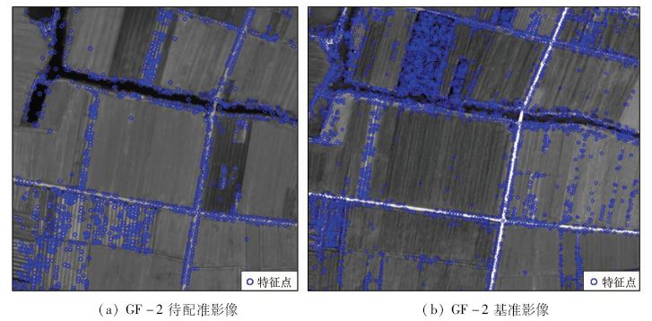
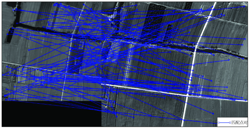
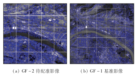
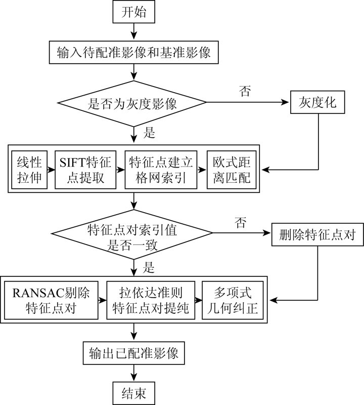
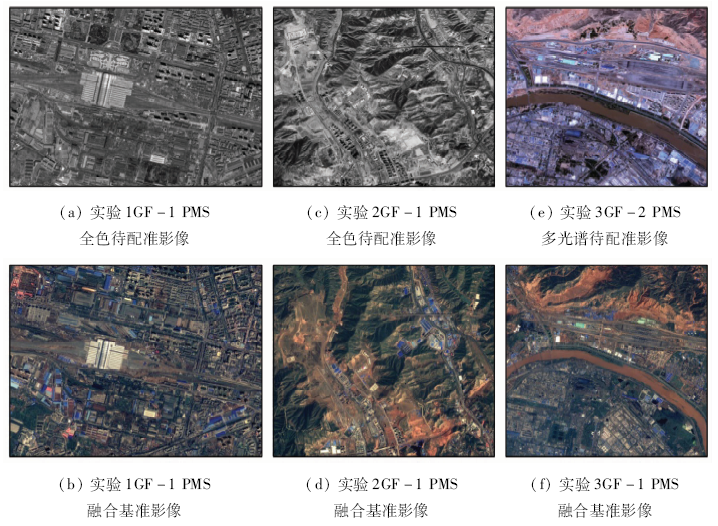
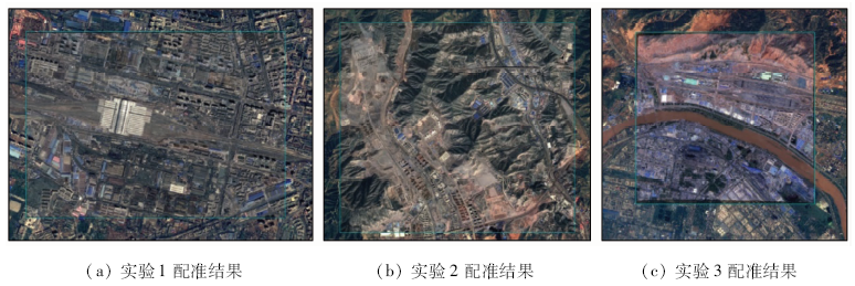
Abstract This paper proposes an algorithm for automatic registration of remote sensing images based on grid index, aiming at tackling the problems of a small number of registration point pairs and a large number of mismatches captured by the SIFT algorithm in the process of remote sensing image registration. First, SIFT algorithm is used to extract feature points and feature vectors, and matching is made by Euclidean distance; secondly, a grid index is established to eliminate part of the mismatched point pairs, thereby improving the accuracy of the random sampling consensus algorithm; finally, geometric polynomials are used to achieve accurate registration of remote sensing images. The experimental results show that the algorithm has higher accuracy of matching point pairs than the traditional block algorithm in remote sensing images, and takes into account the differences in registration scenes of different remote sensing images.
|
| Keywords
SIFT
grid index
RANSAC
image registration
|
|
|
|
Corresponding Authors:
YANG Shuwen
E-mail: 642722474@qq.com;ysw040966@163.com
|
|
Issue Date: 18 March 2021
|
|
|
| [1] |
李孚煜, 叶发茂. 基于SIFT的遥感图像配准技术综述[J]. 国土资源遥感, 2016,28(2):14-20.doi: 10.6046/gtzyyg.2016.02.03.
|
| [1] |
Li F Y, Ye F M. Summarization of SIFT-based remote sensing image registration techniques[J]. Remote Sensing for Land and Resources, 2016,28(2):14-20.doi: 10.6046/gtzyyg.2016.02.03.
|
| [2] |
Lowe D G. Object recognition from local scale-invariant features[C]// iccv.IEEE Computer Society, 1999.
|
| [3] |
Lowe D G. Distinctive image features from scale-invariant keypoints[J]. International Journal of Computer Vision, 2004,60(2):91-110.
doi: 10.1023/B:VISI.0000029664.99615.94
url: http://www.springerlink.com/content/h4l02691327px768/
|
| [4] |
Mikolajczyk K, Schmid C. A performance evaluation of local descriptors[J]. IEEE Trans Pattern Analysis and Machine Intelligence, 2005,27(10):1615-1630.
doi: 10.1109/TPAMI.2005.188
url: http://ieeexplore.ieee.org/document/1498756/
|
| [5] |
李晓明, 郑链, 胡占义. 基于SIFT特征的遥感影像自动配准[J]. 遥感学报, 2006,10(6):885-892.
pmid: 29938116
|
| [5] |
Li X M, Zheng L, Hu Z Y. SIFT based automatic registration of remotely-sensed imagery[J]. Journal of Remote Sensing, 2006,10(6):885-892.
doi: 10.3390/rs10060885
pmid: 29938116
url: https://www.ncbi.nlm.nih.gov/pubmed/29938116
|
| [6] |
Fischler M A, Bolles R C. Random sample consensus:A paradigm for model fitting with applications to image analysis and automated cartography[J]. Communications of the ACM, 1981,24(6):381-395.
doi: 10.1145/358669.358692
url: https://dl.acm.org/doi/10.1145/358669.358692
|
| [7] |
程焱, 周焰, 林洪涛. 基于SIFT特征遥感影像自动配准与拼接[J]. 遥感技术与应用, 2008,23(6):721-728,608.
url: http://www.rsta.ac.cn/CN/abstract/abstract31.shtml
|
| [7] |
Cheng Y, Zhou Y, Lin H T. Automatic registration and mosaic of remote sensed imagery based on SIFT feature[J]. Remote Sensing Technology and Application, 2008,23(6):721-728,608.
url: http://www.rsta.ac.cn/CN/abstract/abstract31.shtml
|
| [8] |
李芳芳, 肖本林, 贾永红, 等. SIFT算法优化及其用于遥感影像自动配准[J]. 武汉大学学报(信息科学版), 2009,34(10):1245-1249.
|
| [8] |
Li F F, Xiao B L, Jia Y H, et al. Improved SIFT algorithm and its application in automatic registration of remotely-sensed imagery[J]. Geomatics and Information Science of Wuhan University, 2009,34(10):1245-1249.
url: http://ch.whu.edu.cn/CN/abstract/abstract1411.shtml
|
| [9] |
程红, 陈文剑. 基于SIFT算法的图像匹配剔点方法研究[J]. 地理与地理信息科学, 2012,28(6):17-19,27.
|
| [9] |
Cheng H, Chen W J. A method to reject points based on SIFT for image matching[J]. Geography and Geo-Information Science, 2012,28(6):17-19,27.
|
| [10] |
张谦, 贾永红, 胡忠文. 多源遥感影像配准中的SIFT特征匹配改进[J]. 武汉大学学报(信息科学版), 2013,38(4):455-459.
|
| [10] |
Zhang Q, Jia Y H, Hu Z W. An improved SIFT algorithm for multi-source remote sensing image registration[J]. Geomatics and Information Science of Wuhan University, 2013,38(4):455-459.
|
| [11] |
张谦, 贾永红, 吴晓良, 等. 一种带几何约束的大幅面遥感影像自动快速配准方法[J]. 武汉大学学报(信息科学版), 2014,39(1):17-21,31.
|
| [11] |
Zhang Q, Jia Y H, Wu X L, et al. A rapid image registration method based on restricted geometry constraints for large-size remote sensing image[J]. Geomatics and Information Science of Wuhan University, 2014,39(1):17-21,31.
|
| [12] |
沈宇臻, 李百寿, 李灵芝. 一种基于邻域投票的异源光学影像SIFT匹配误差剔除方法[J]. 测绘通报, 2018(2):55-60,93.
|
| [12] |
Shen Y Z, Li B S, Li L Z. A method of SIFT matching error elimination for heterogeneous optical images based on neighborhood voting[J]. Bulletin of Surveying and Mapping, 2018(2):55-60,93.
|
| [13] |
闫浩文, 王明孝, 王中辉 .计算几何: 空间数据处理算法[M]. 北京: 科学出版社, 2012.
|
| [13] |
Yan H W, Wang M X, Wang Z H. Computational geometry:Spatial data processing algorithms[M]. Beijing: Science Press, 2012.
|
| [14] |
朱志文, 沈占锋, 骆剑承. 改进SIFT点特征的并行遥感影像配准[J]. 遥感学报, 2011,15(5):1024-1039.
|
| [14] |
Zhu Z W, Shen Z F, Luo J C. Parallel remote sensing image registration based on improved SIFT point feature[J]. Journal of Remote Sensing, 2011,15(5):1024-1039.
|
|
Viewed |
|
|
|
Full text
|
|
|
|
|
Abstract
|
|
|
|
|
Cited |
|
|
|
|
| |
Shared |
|
|
|
|
| |
Discussed |
|
|
|
|
 2021,
Vol. 33
2021,
Vol. 33