|
|
 |
|

|
|
|
Remote sensing observations of tidal flats, shorelines, and aquacultural water bodies along coastal zones in China mainland during 1989—2021 |
YAN Bokun1,2( ), GAN Fuping1,2, YIN Ping3, GE Xiaoli1,2, GUO Yi1,2, BAI Juan1,2 ), GAN Fuping1,2, YIN Ping3, GE Xiaoli1,2, GUO Yi1,2, BAI Juan1,2 |
1. China Aero Geophysical Survey and Remote Sensing Center for Natural Resources, Beijing 100083, China
2. Key Laboratory of Airborne Geophysics and Remote Sensing Geology, Ministry of Natural Resources, Beijing 100083, China
3. Qingdao Institute of Marine Geology, Qingdao 266237, China |
|
|
|
|
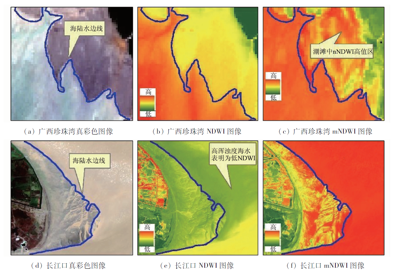
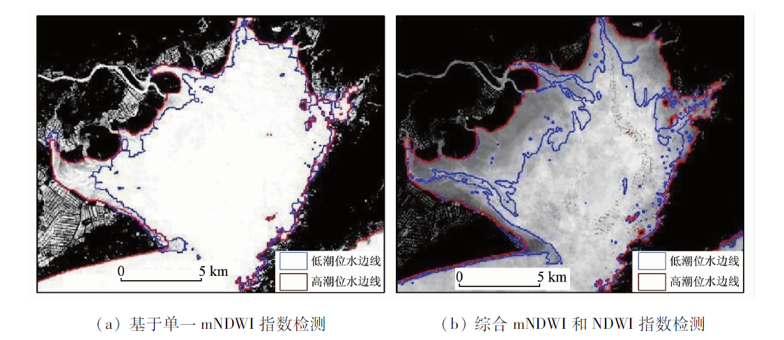
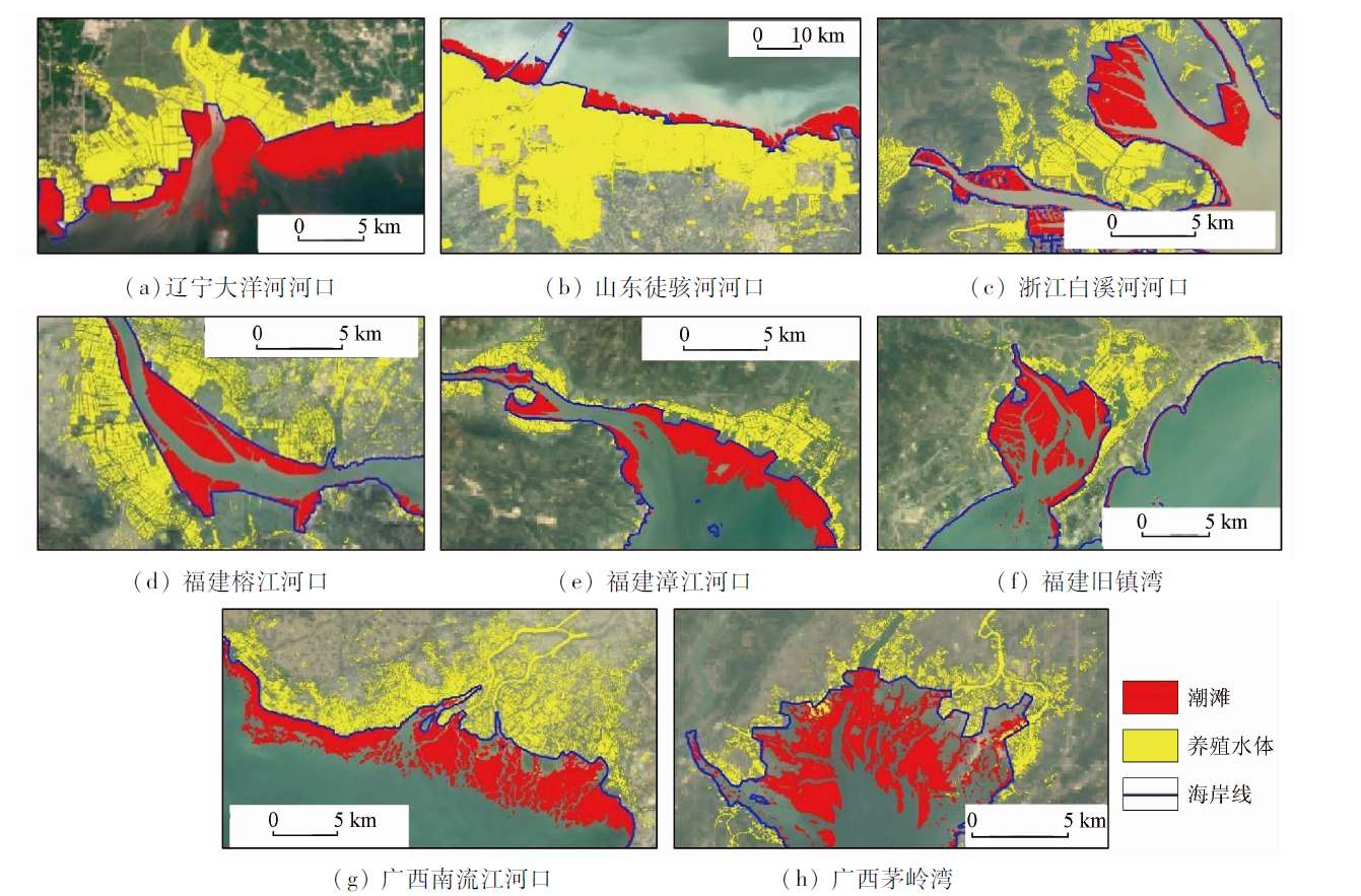
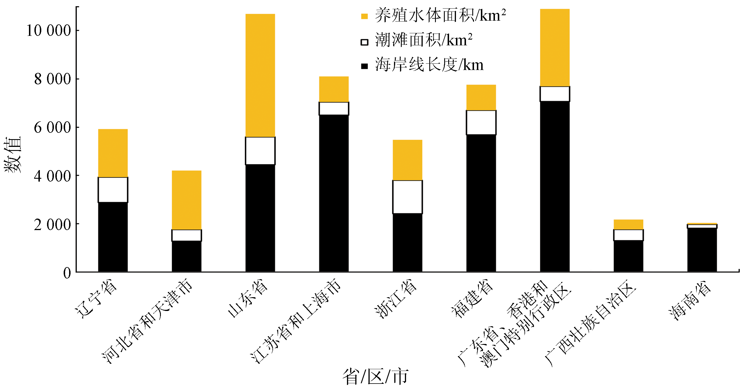
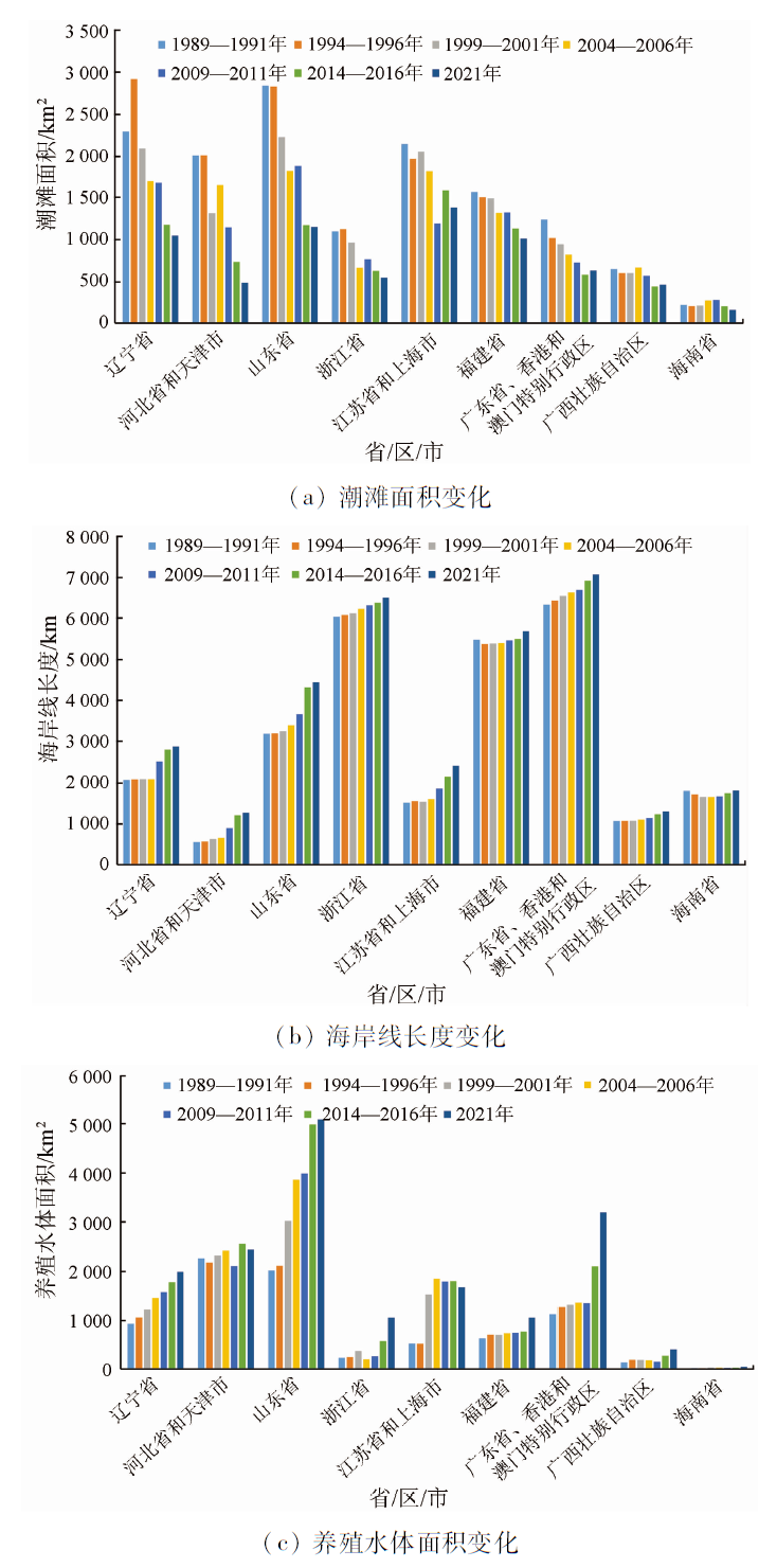
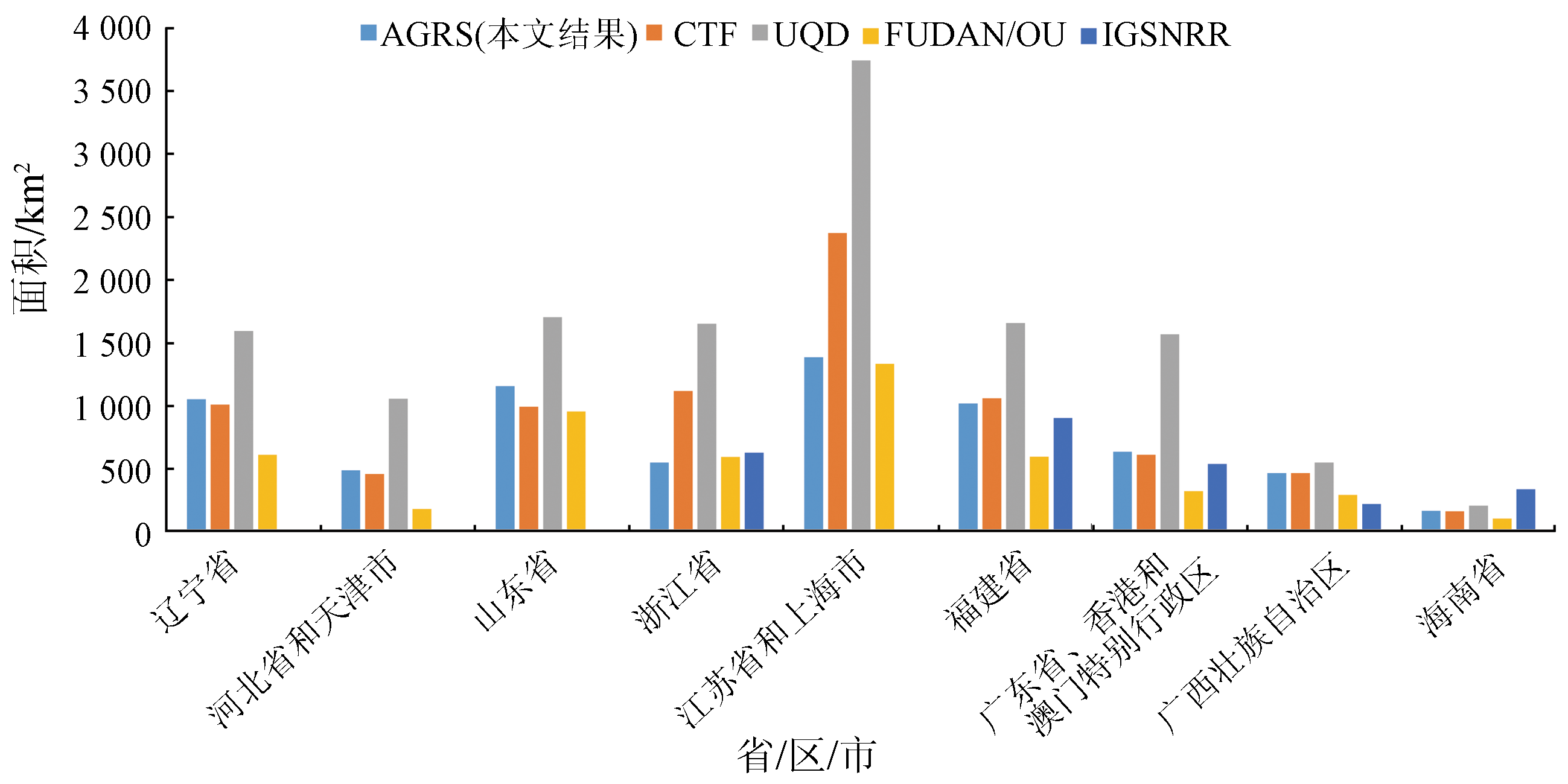
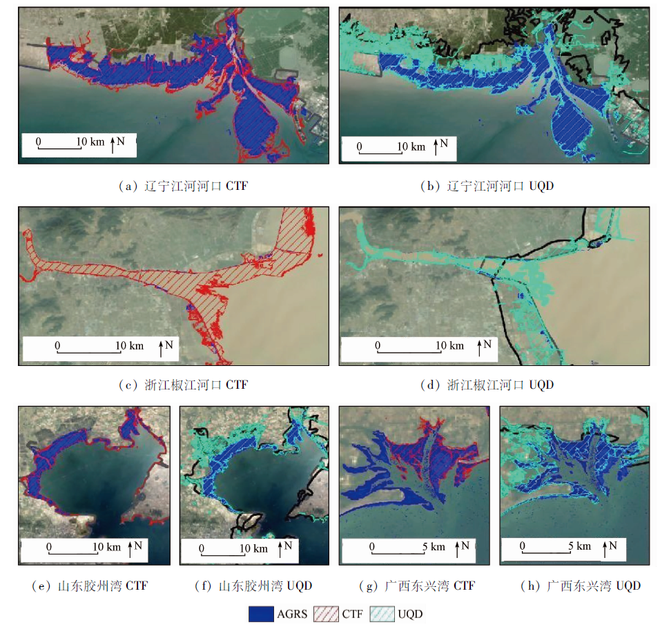
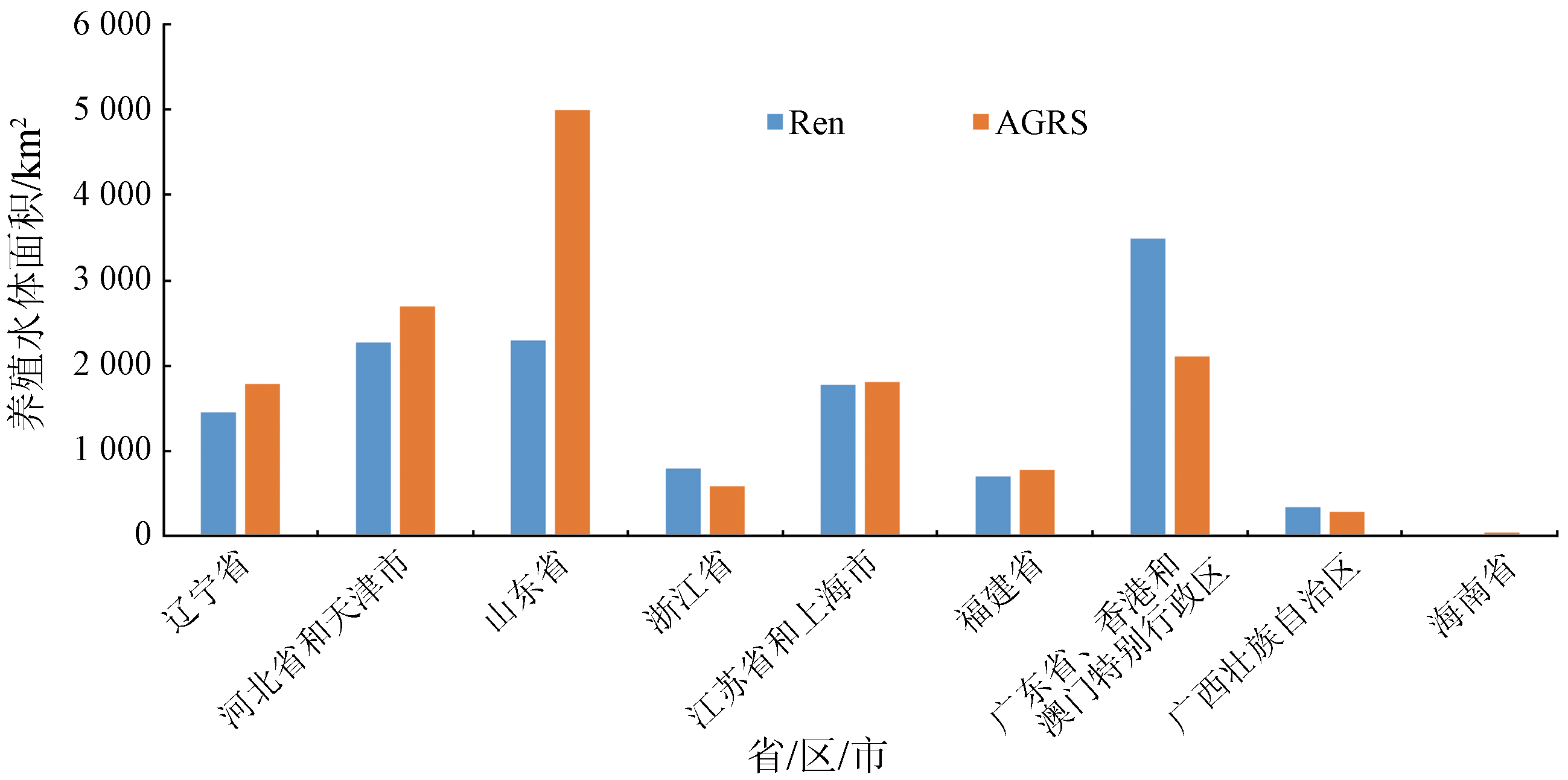
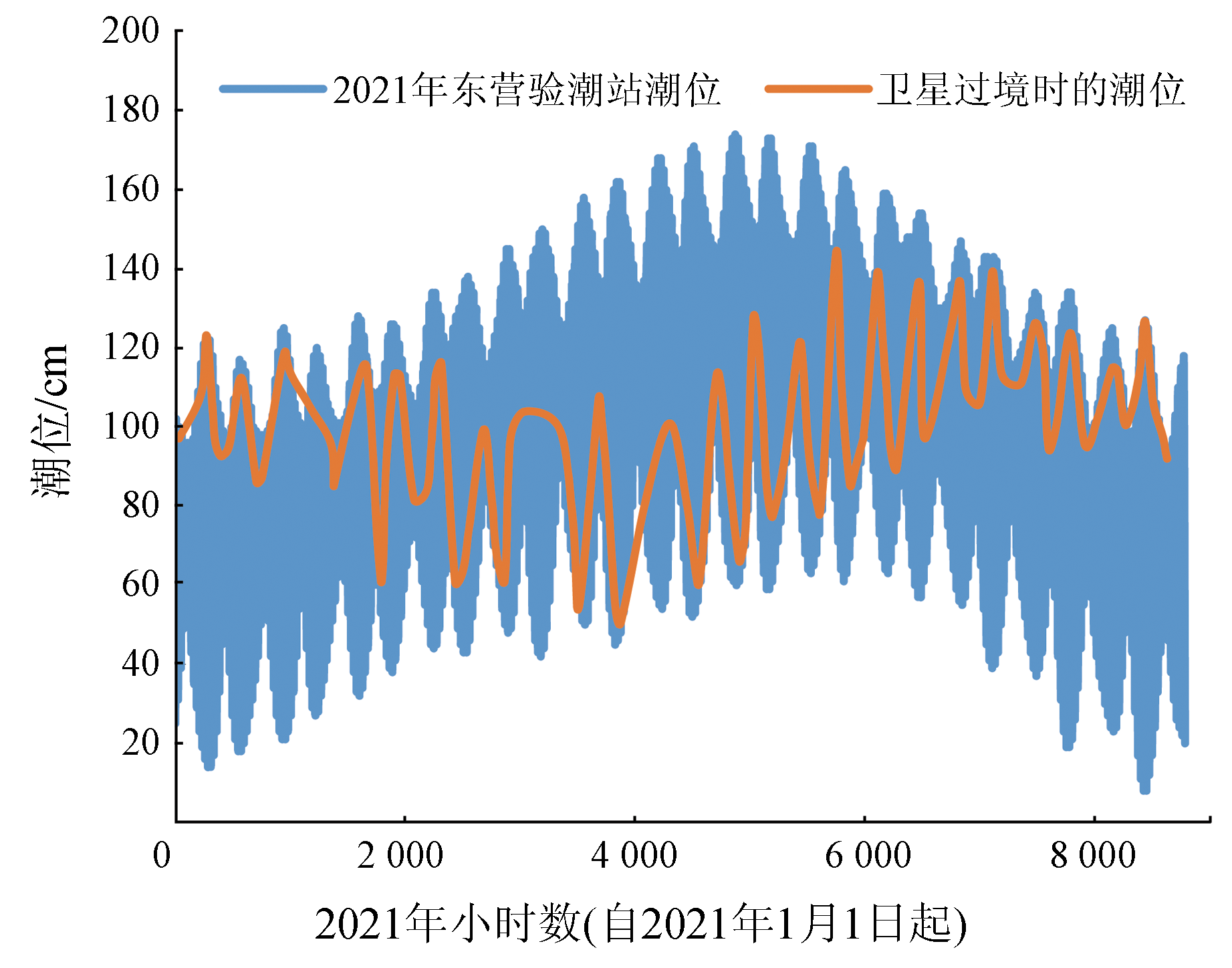
Abstract Coastal zones are the world’s most populated areas, with their ecosystems being strongly influenced by human activities. Tidal flats, shorelines, and aquacultural water bodies are critical elements in monitoring the health of coastal zone ecosystems. However, the dynamic changes in the waterlines between land and sea areas caused by tidal effects make it challenging to detect tidal flats and shorelines using the remote sensing technology. By integrating Landsat4/5/7/8 and Sentinel-2A/B satellite remote sensing images, this study conducted seven phases (1989—2021) of monitoring of tidal flats, shorelines, and aquacultural water bodies along coastal zones in China mainland. By taking advantage of the high frequency of multi-source satellite observations, this study identified tidal flats, shorelines, and aquacultural water bodies by detecting the waterlines at different tidal levels. The results are as follows: ① Seawater of different colors requires different combinations of water body indices. For clear or low-turbidity seawater, this study selected the modified normalized difference water index (mNDWI) and the normalized difference water index (NDWI) to detect the waterlines at high and low tidal levels, respectively. This improved the reliability of tidal flat detection, with the detected tidal flat area being 122% larger than that detected only using the mNDWI. For high-turbidity seawater (in Zhejiang, Jiangsu, and Shanghai), this study selected mNDWI to detect the waterlines at high and low tidal levels, avoiding misidentifying high-turbidity seawater as tidal flats using NDWI. Besides, this study selected NDWI to detect aquacultural water bodies. ② During 1989—2021, coastal zones in China mainland changed significantly, as evidenced by rapidly decreased tidal flats and increased aquacultural water bodies and shorelines. The decreased rate of tidal flats and the increased rates of shorelines and aquacultural water bodies along the coastal zones averaged 46.2%, 34.4%, and 149.3%, respectively. Correspondingly, the tidal flat area decreased by 7 173.2 km2, while the the shoreline length and aquacultural water body area increased by 5 320.5 km and 9 046.5 km2, respectively. Provinces or cities in northern China suffered more tidal flat losses than those in southern China. Based on the average decrease rate of tidal flats during 1989—2021, tidal flats in Liaoning, Hebei and Tianjin, and Shandong will disappear within 27 a, 10 a, and 22 a, respectively. ③ The area changes between tidal flats and aquacultural water bodies are highly negatively correlated, indicating that the expansion of aquacultural water bodies is a critical driving factor for the decrease in tidal flats.
|
| Keywords
coastal zone
tidal flat
shoreline
estuary
|
|
|
|
Issue Date: 19 September 2023
|
|
|
| [1] |
Primavera J H. Overcoming the impacts of aquaculture on the coastal zone[J]. Ocean and Coastal Management, 2006, 49(9-10):531-545.
doi: 10.1016/j.ocecoaman.2006.06.018
url: https://linkinghub.elsevier.com/retrieve/pii/S0964569106000755
|
| [2] |
Ren C, Wang Z, Zhang Y, et al. Rapid expansion of coastal aquaculture ponds in China from Landsat observations during 1984—2016[J]. International Journal of Applied Earth Observation and Geoinformation, 2019, 82:101902.
doi: 10.1016/j.jag.2019.101902
url: https://linkinghub.elsevier.com/retrieve/pii/S0303243419304295
|
| [3] |
Wu T, Hou X, Xu X. Spatio-temporal characteristics of the mainland coastline utilization degree over the last 70 years in China[J]. Ocean and Coastal Management, 2014, 98:150-157.
doi: 10.1016/j.ocecoaman.2014.06.016
url: https://linkinghub.elsevier.com/retrieve/pii/S0964569114001999
|
| [4] |
Sun Z, Luo J, Yang J, et al. Nation-scale mapping of coastal aquaculture ponds with Sentinel-1 SAR data using Google Earth Engine[J]. Remote Sensing, 2020, 12(18):3086.
doi: 10.3390/rs12183086
url: https://www.mdpi.com/2072-4292/12/18/3086
|
| [5] |
Cao L, Naylor R, Henriksson P, et al. China’s aquaculture and the world’s wild fisheries[J]. Science, 2015, 347(6218):133-135.
doi: 10.1126/science.1260149
url: https://www.science.org/doi/10.1126/science.1260149
|
| [6] |
Ottinger M, Clauss K, Kuenzer C. Large-scale assessment of coastal aquaculture ponds with Sentinel-1 time series data[J]. Remote Sensing, 2017, 9(5):440.
doi: 10.3390/rs9050440
url: http://www.mdpi.com/2072-4292/9/5/440
|
| [7] |
Murray N J, Phinn S R, Dewitt M, et al. The global distribution and trajectory of tidal flats[J]. Nature, 2019, 565(7738):222-225.
doi: 10.1038/s41586-018-0805-8
|
| [8] |
Murray N J, Clemens R S, Phinn S R, et al. Tracking the rapid loss of tidal wetlands in the Yellow Sea[J]. Frontiers in Ecology and the Environment, 2014, 12(5):267-272.
doi: 10.1890/130260
url: http://doi.wiley.com/10.1890/130260
|
| [9] |
Wang X, Xiao X, Zou Z, et al. Mapping coastal wetlands of China using time series Landsat images in 2018 and Google Earth Engine[J]. ISPRS Journal of Photogrammetry and Remote Sensing, 2020, 163:312-326.
doi: 10.1016/j.isprsjprs.2020.03.014
pmid: 32405155
|
| [10] |
Moore L J, Ruggiero P, List J H. Comparing mean high water and high water line shorelines:Should proxy-datum offsets be incorporated into shoreline change analysis?[J]. Journal of Coastal Research, 2006, 224:894-905.
doi: 10.2112/04-0401.1
url: http://www.bioone.org/doi/abs/10.2112/04-0401.1
|
| [11] |
Dyer K R, Christie M C, Wright E W. The classification of intertidal mudflats[J]. Continental Shelf Research, 2000, 20(10-11):1039-1060.
doi: 10.1016/S0278-4343(00)00011-X
url: https://linkinghub.elsevier.com/retrieve/pii/S027843430000011X
|
| [12] |
Pajak M J, Leatherman S P. The high water line as shoreline indicator[J]. Journal of Coastal Research, 2002, 18(2):329-337.
|
| [13] |
García-Rubio G, Huntley D, Russell P. Evaluating shoreline identification using optical satellite images[J]. Marine Geology, 2015, 359:96-105.
doi: 10.1016/j.margeo.2014.11.002
url: https://linkinghub.elsevier.com/retrieve/pii/S0025322714003259
|
| [14] |
Li W, Gong P. Continuous monitoring of coastline dynamics in western Florida with a 30-year time series of Landsat imagery[J]. Remote Sensing of Environment, 2016, 179:196-209.
doi: 10.1016/j.rse.2016.03.031
url: https://linkinghub.elsevier.com/retrieve/pii/S0034425716301249
|
| [15] |
Yang X, Zhu Z, Qiu S, et al. Detection and characterization of coastal tidal wetland change in the northeastern US using Landsat time series[J]. Remote Sensing of Environment, 2022, 276:113047.
doi: 10.1016/j.rse.2022.113047
url: https://linkinghub.elsevier.com/retrieve/pii/S0034425722001614
|
| [16] |
Sagar S, Roberts D, Bala B, et al. Extracting the intertidal extent and topography of the Australian coastline from a 28 year time series of Landsat observations[J]. Remote Sensing of Environment, 2017, 195:153-169.
doi: 10.1016/j.rse.2017.04.009
url: https://linkinghub.elsevier.com/retrieve/pii/S0034425717301591
|
| [17] |
Zhao C, Qin C Z, Teng J. Mapping large-area tidal flats without the dependence on tidal elevations:A case study of Southern China[J]. ISPRS Journal of Photogrammetry and Remote Sensing, 2020, 159:256-270.
doi: 10.1016/j.isprsjprs.2019.11.022
url: https://linkinghub.elsevier.com/retrieve/pii/S0924271619302813
|
| [18] |
Jia M, Wang Z, Mao D, et al. Rapid,robust,and automated mapping of tidal flats in China using time series Sentinel-2 images and Google Earth Engine[J]. Remote Sensing of Environment, 2021, 255:112285.
doi: 10.1016/j.rse.2021.112285
url: https://linkinghub.elsevier.com/retrieve/pii/S0034425721000031
|
| [19] |
Chang M, Li P, Li Z, et al. Mapping tidal flats of the Bohai and Yellow Seas using time series Sentinel-2 images and Google Earth Engine[J]. Remote Sensing, 2022, 14(8):1789.
doi: 10.3390/rs14081789
url: https://www.mdpi.com/2072-4292/14/8/1789
|
| [20] |
Wang X, Xiao X, Zou Z, et al. Tracking annual changes of coastal tidal flats in China during 1986—2016 through analyses of Landsat images with Google Earth Engine[J]. Remote Sensing of Environment, 2020, 238:110987.
doi: 10.1016/j.rse.2018.11.030
url: https://linkinghub.elsevier.com/retrieve/pii/S003442571830539X
|
| [21] |
Gorelick N, Hancher M, Dixon M, et al. Google Earth Engine:Planetary-scale geospatial analysis for everyone[J]. Remote Sensing of Environment, 2017, 202:18-27.
doi: 10.1016/j.rse.2017.06.031
url: https://linkinghub.elsevier.com/retrieve/pii/S0034425717302900
|
| [22] |
Davranche A, Lefebvre G, Poulin B. Wetland monitoring using classification trees and SPOT-5 seasonal time series[J]. Remote Sensing of Environment, 2010, 114(3):552-562.
doi: 10.1016/j.rse.2009.10.009
url: https://linkinghub.elsevier.com/retrieve/pii/S0034425709003186
|
| [23] |
Feng L, Hu C, Chen X, et al. Assessment of inundation changes of Poyang Lake using MODIS observations between 2000 and 2010[J]. Remote Sensing of Environment, 2012, 121:80-92.
doi: 10.1016/j.rse.2012.01.014
url: https://linkinghub.elsevier.com/retrieve/pii/S0034425712000491
|
| [24] |
Feyisa G L, Meilby H, Fensholt R, et al. Automated water extraction index:A new technique for surface water mapping using Landsat imagery[J]. Remote Sensing of Environment, 2014, 140:23-35.
doi: 10.1016/j.rse.2013.08.029
url: https://linkinghub.elsevier.com/retrieve/pii/S0034425713002873
|
| [25] |
Xu H. Modification of normalised difference water index (NDWI) to enhance open water features in remotely sensed imagery[J]. International Journal of Remote Sensing, 2006, 27(14):3025-3033.
doi: 10.1080/01431160600589179
url: https://www.tandfonline.com/doi/full/10.1080/01431160600589179
|
| [26] |
Zhou Y, Dong J, Xiao X, et al. Continuous monitoring of lake dynamics on the Mongolian Plateau using all available Landsat imagery and Google Earth Engine[J]. Science of the Total Environment, 2019, 689:366-380.
doi: 10.1016/j.scitotenv.2019.06.341
|
|
Viewed |
|
|
|
Full text
|
|
|
|
|
Abstract
|
|
|
|
|
Cited |
|
|
|
|
| |
Shared |
|
|
|
|
| |
Discussed |
|
|
|
|
 2023,
Vol. 35
2023,
Vol. 35