|
|
 |
|

|
|
|
Remote sensing monitoring based analysis of the spatio-temporal changing characteristics of regional urban expansion and urban land cover in China’s coastal zones |
SHI Shushu1,2( ), DOU Yinyin3, CHEN Yongqiang1(), KUANG Wenhui3 ), DOU Yinyin3, CHEN Yongqiang1(), KUANG Wenhui3 |
1. Space Microwave Remote Sensing System Department, Aerospace Information Research Institute, Chinese Academy of Sciences, Beijing 100089, China
2. University of Chinese Academy of Sciences, Beijing 100049, China
3. Key Laboratory of Land Surface Pattern and Simulation, Institute of Geographic Sciences and Natural Resources Research, Chinese Academy of Sciences, Beijing 100101, China |
|
|
|
|
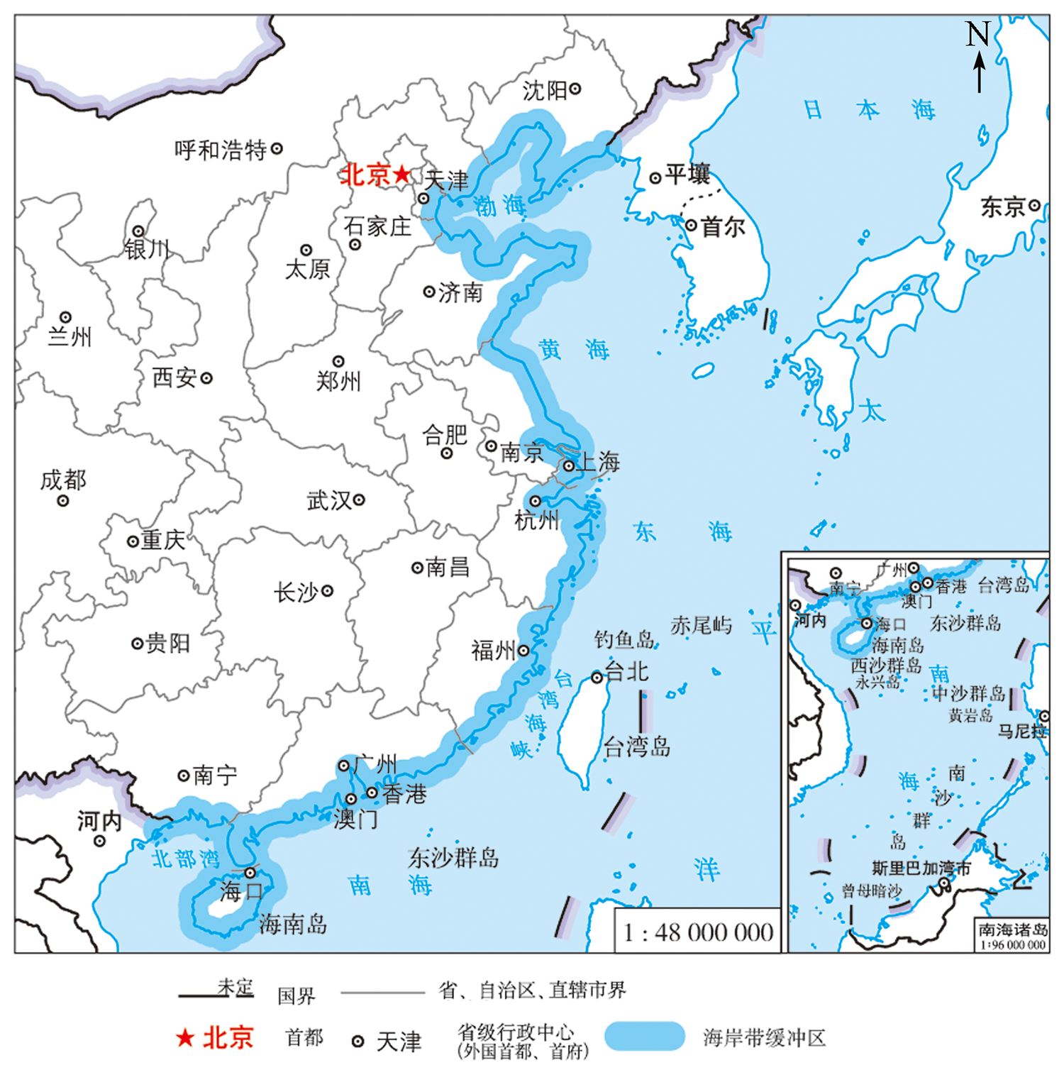
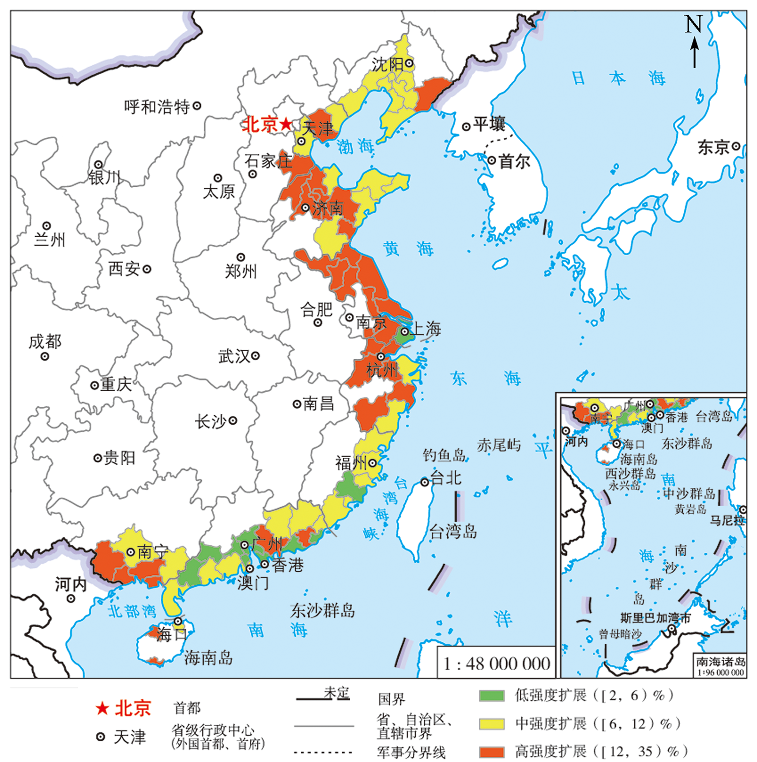
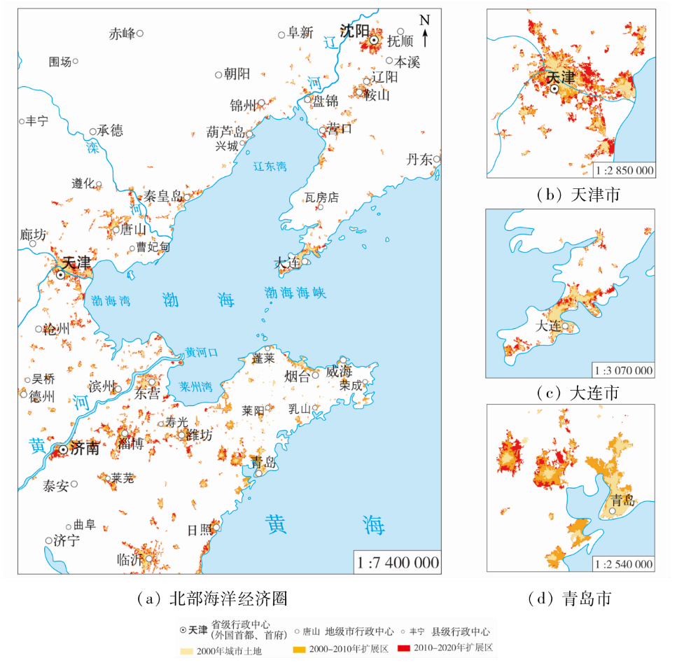
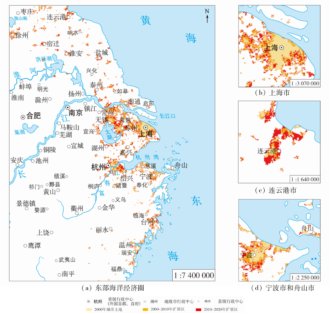
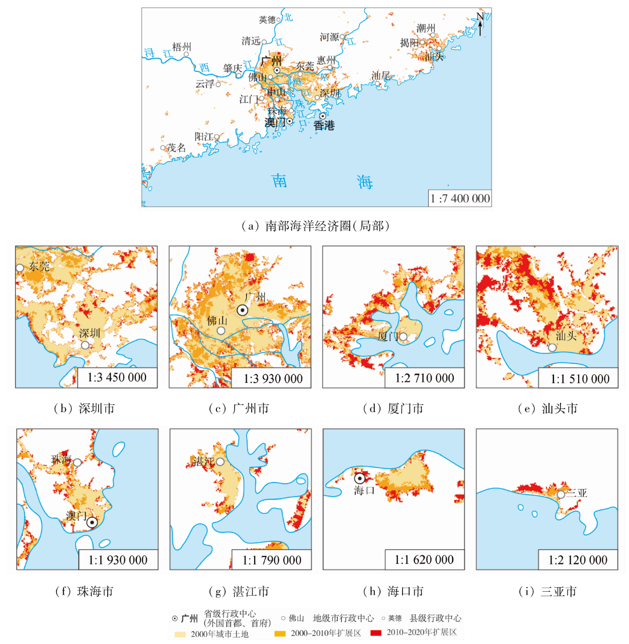
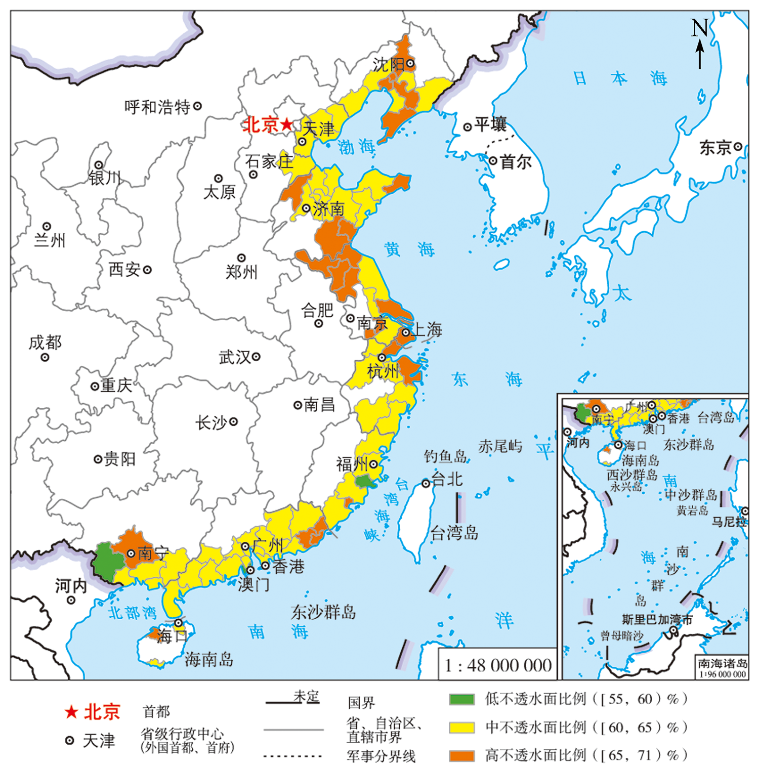
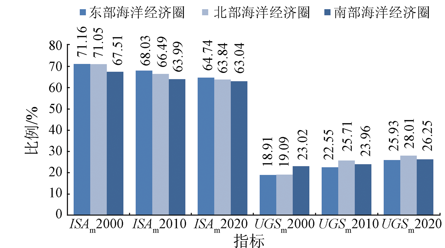
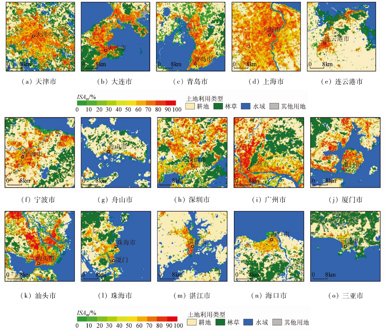
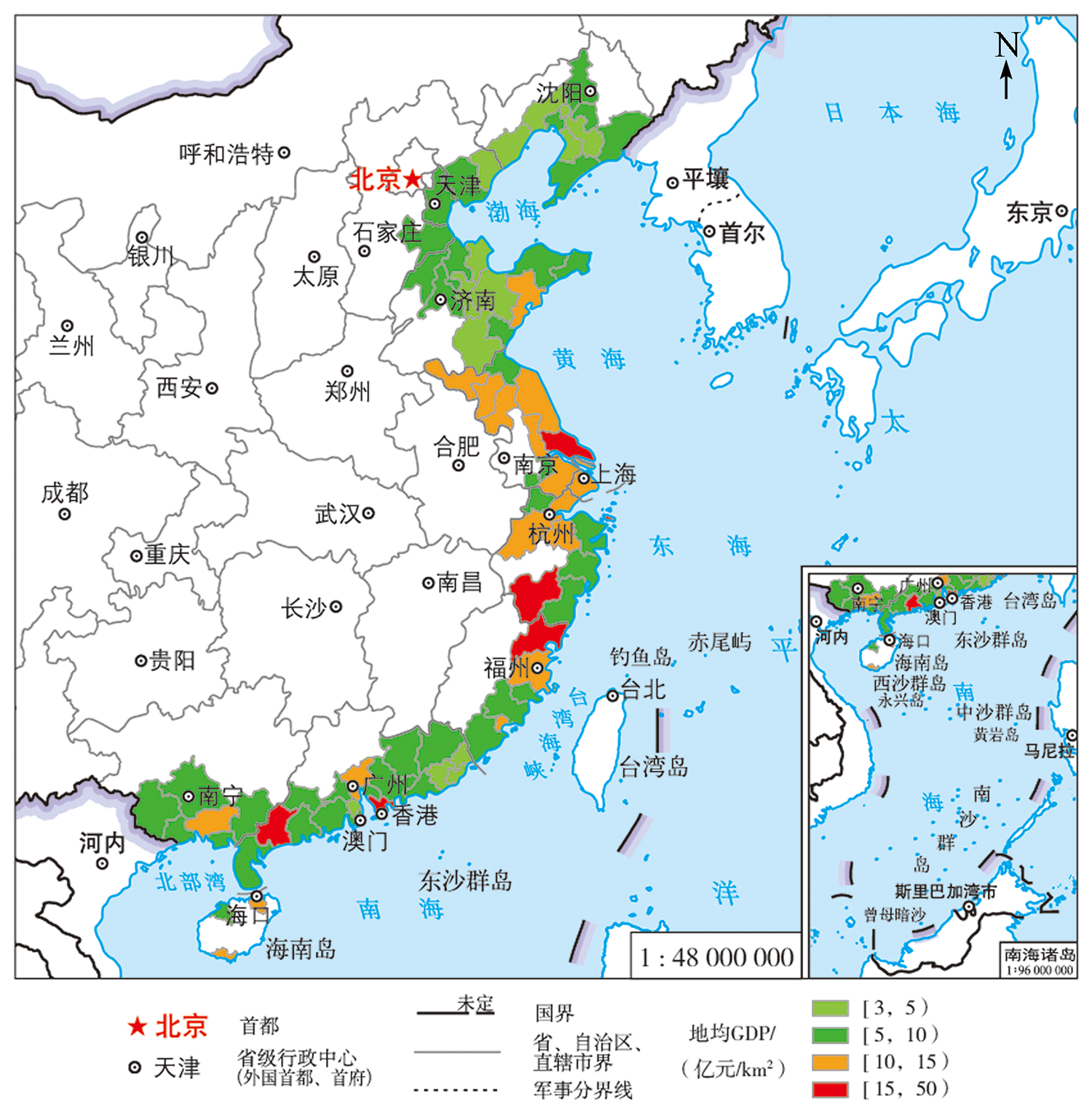
Abstract Changes in urban expansion and urban land cover structures greatly affect the urban ecological environment and even ecological security. The highly concentrated urban population and economic activities and the resultant rapid urbanization have caused dramatic changes in urban expansion and urban land cover structures in China’s coastal zone. However, previous study data are insufficient for a clear understanding of the urban expansion and urban land cover structures in China’s coastal zone. In light of this, this study analyzed the spatio-temporal changing characteristics of the abovementioned aspects from multiple perspectives using the global urban land use/cover composites with 30 m spatial resolution (GULUC-30). The results are as follows. The urban land area in China’s coastal zone increased from 16 600 km2 in 2000 to 48 000 km2 in 2020, with an expansion intensity of 9.41%. The regional cities in high-density expansion accounted for 41.03% and were mainly located in the north-central portion of the coastal zone. Cities in China’s coastal zone were expanding rapidly at a rate of 1 260.04 km2/a from 2000 to 2010 and 1 871.74 km2/a from 2010 to 2020. The urban impervious surface area had continued to increase over the past two decades. However, the proportion of the urban impervious surface decreased while that of urban green space increased. In 2000, the areas of urban impervious surface and urban green space in China’s coastal zone accounted for 69.49% and 20.81% of the urban land area, respectively. By 2020, they accounted for 63.70% and 26.72%, respectively. The urban expansion of 83.33% of the cities in China’s coastal zone was ahead of the urban population growth. The small cities have large GDP per urban land and high land use efficiency. The study can provide an important scientific basis and decision support for regional urban planning and sustainable development of China’s coastal zone.
|
| Keywords
China’s coastal zone
urban expansion
land use/cover
impervious surface
green space
|
|
|
|
Issue Date: 27 December 2022
|
|
|
| [1] |
骆永明. 中国海岸带可持续发展中的生态环境问题与海岸科学发展[J]. 中国科学院院刊, 2016, 31(10):1133-1142.
|
| [1] |
Luo Y M. Sustainability associated coastal eco-environmental problems and coastal science development in China[J]. Bulletin of the Chinese Academy of Sciences, 2016, 31(10):1133-1142.
|
| [2] |
许学工, 彭慧芳, 徐勤政. 海岸带快速城市化的土地资源冲突与协调——以山东半岛为例[J]. 北京大学学报(自然科学版), 2006, 42(4):527-533.
|
| [2] |
Xu X G, Peng H F, Xu Q Z. Land resource conflicts and coordination in fast urbanized coastal zone:A case study of the Shandong Peninsula[J]. Acta Scientiarum Naturalium Universitatis Pekinensis, 2006, 42(4):527-533.
|
| [3] |
匡文慧, 迟文峰, 史文娇. 中国与美国大都市区城市内部土地覆盖结构时空差异[J]. 地理学报, 2014, 69(7):883-895.
doi: 10.11821/dlxb201407001
|
| [3] |
Kuang W H, Chi W F, Shi W J. Spatio-temporal characteristics of intra-urban land cover in the cities of China and USA from 1978 to 2010[J]. Acta Geographica Sinica, 2014, 69(7):883-895.
doi: 10.11821/dlxb201407001
|
| [4] |
Kuang W H. National urban land-use cover change since the beginning of the 21st century and its policy implications in China[J]. Land Use Policy, 2020, 97: 104747.
doi: 10.1016/j.landusepol.2020.104747
url: https://linkinghub.elsevier.com/retrieve/pii/S0264837719300900
|
| [5] |
Kuang W H, Liu J Y, Zhang Z X, et al. Spatiotemporal dynamics of impervious surface areas across China during the early 21st century[J]. Chinese Science Bulletin, 2013, 58(14):1691-1701.
doi: 10.1007/s11434-012-5568-2
url: http://link.springer.com/10.1007/s11434-012-5568-2
|
| [6] |
吴文挺, 田波, 周云轩, 等. 中国海岸带围垦遥感分析[J]. 生态学报, 2016, 36(16):5007-5016.
|
| [6] |
Wu W T, Tian B, Zhou Y X, et al. The trends of coastal reclamation in China in the past three decades[J]. Acta Ecologica Sinica, 2016, 36(16):5007-5016.
|
| [7] |
匡文慧, 陈利军, 刘纪远, 等. 亚洲人造地表覆盖遥感精细化分类与分布特征分析[J]. 中国科学:地球科学, 2016, 46:1162-1179.
|
| [7] |
Kuang W H, Chen L J, Liu J Y, et al. Remote sensing-based artificial surface cover classification in Asia and spatial pattern analysis[J]. Science China Earth Sciences, 2016, 59:1720-1737.
doi: 10.1007/s11430-016-5295-7
url: http://link.springer.com/10.1007/s11430-016-5295-7
|
| [8] |
Kuang W H, Dou Y Y. Investigating the patterns and dynamics of urban green space in China’s 70 major cities using satellite remote sensing[J]. Remote Sensing, 2020, 12:1929.
doi: 10.3390/rs12121929
url: https://www.mdpi.com/2072-4292/12/12/1929
|
| [9] |
杨俊, 孙静, 葛全胜. 大连市城区绿地时空特征的热环境效应研究[J]. 地球信息科学学报, 2016, 18(8):1087-1093.
doi: 10.3724/SP.J.1047.2016.01087
|
| [9] |
Yang J, Sun J, Ge Q S. Study on thermal environmental effect of spatial-temporal characteristics of urban green space in the city of Dalian[J]. Journal of Geo-Information Science, 2016, 18(8):1087-1093.
|
| [10] |
刘春亭, 冯权泷, 金鼎坚, 等. 随机森林协同Sentinel-1/2的东营市不透水层信息提取[J]. 自然资源遥感, 2021, 33(3):253-261.doi:10.6046/zrzyyg.2020310.
doi: 10.6046/zrzyyg.2020310
|
| [10] |
Liu C T, Feng Q L, Jin D J, et al. Application of random forest and Sentinel-1/2 in the information extraction of impervious layers in Dongying City[J]. Remote Sensing for Natural Resources, 2021, 33 (3):253-261.doi:10.6046/zrzyyg.2020310.
doi: 10.6046/zrzyyg.2020310
|
| [11] |
张训华, 孙晓明, 印萍, 等. 推进海岸带综合地质调查,为社会经济持续发展提供支撑[J]. 海洋地质前沿, 2015, 31(1):1-8.
|
| [11] |
Zhang X H, Sun X M, Yin P, et al. Sustainable development of coastal zone based on integrated geological investigation[J]. Marine Geology Frontiers, 2015, 31(1):1-8.
|
| [12] |
曹慧博, 张颖, 杨静, 等. 基于三维生态足迹扩展模型的中国海岸带生态足迹及其影响因素研究[J]. 水土保持通报, 2021, 41(1):252-259.
|
| [12] |
Cao H B, Zhang Y, Yang J, et al. A study of ecological footprint and its influencing factors in China’s coastal zone based on three-dimensional ecological footprint expansion model[J]. Bulletin of Soil and Water Conservation, 2021, 41(1):252-259.
|
| [13] |
陈述彭. 海岸带及其持续发展[J]. 遥感信息, 1996(3): 6-12.
|
| [13] |
Chen S P. Coastal zone and its sustainable development[J]. Remote Sensing Information, 1996(3): 6-12.
|
| [14] |
Liu F, Zhang Z X, Shi L F, et al. Urban expansion in China and its spatial-temporal differences over the past four decades[J]. Journal of Geographical Sciences, 2016, 26(10):1477-1496.
doi: 10.1007/s11442-016-1339-3
url: http://link.springer.com/10.1007/s11442-016-1339-3
|
| [15] |
Barragán J M, de Andrés M. Urban expansion in the coastal areas of Latin America and Caribbean[J]. Revista de Geografía Norte Grande, 2016, 64:129-149.
|
| [16] |
马金卫, 吴晓青, 周迪, 等. 海岸带城镇空间扩展情景模拟及其生态风险评价[J]. 资源科学, 2012, 34(1):185-194.
|
| [16] |
Ma J W, Wu X Q, Zhou D, et al. Scenario simulation of urban spatial expansion and its ecological risks assessment in coastal zones[J]. Resources Science, 2012, 34(1):185-194.
|
| [17] |
吝涛, 李新虎, 张国钦, 等. 厦门岛城市空间扩张特征及其影响因素分析[J]. 地理学报, 2010, 65(6):715-726.
|
| [17] |
Lin T, Li X H, Zhang G Q, et al. Dynamic analysis of island urban spatial expansion and its determinants:A case study of Xiamen Island[J]. Acta Geographica Sinica, 2010, 65(6):715-726.
|
| [18] |
Yu W J, Zhang Y Y, Zhou W Q, et al. Urban expansion in Shenzhen since 1970s:A retrospect of change from a village to a megacity from the space[J]. Physics and Chemistry of the Earth, 2019, 110:21-30.
|
| [19] |
Cao W, Zhou Y, Li R, et al. Monitoring long-term annual urban expansion (1986—2017) in the largest archipelago of China[J]. Science of the Total Environment, 2021:146015.
|
| [20] |
Yan Y C, Ju H R, Zhang S R, et al. Spatiotemporal patterns and driving forces of urban expansion in coastal areas:A study on urban agglomeration in the Pearl River Delta,China[J]. Sustainability, 2019, 12(1): 191.
doi: 10.3390/su12010191
url: https://www.mdpi.com/2071-1050/12/1/191
|
| [21] |
徐进勇, 张增祥, 赵晓丽, 等. 近40年珠江三角洲主要城市时空扩展特征及驱动力分析[J]. 北京大学学报(自然科学版), 2015, 51(6):1119-1131.
|
| [21] |
Xu J Y, Zhang Z X, Zhao X L. et al. Spatial-temporal characteristics and driving forces of urban sprawl for major cities of the Pearl River Delta region in recent 40 years[J]. Acta Scientiarum Naturalium Universitatis Pekinensis, 2015, 51(6):1119-1131.
|
| [22] |
高啸峰, 刘慧平, 张洋华, 等. 1990—2010年长三角城市群城市扩展时空规律分析[J]. 北京师范大学学报(自然科学版), 2016, 52(5):645-650,533.
|
| [22] |
Gao X F, Liu H P, Zhang Y H, et al. Spatio-temporal patterns of urban expansion in Yangtze River Delta Megalopolis from 1990 to 2010[J]. Journal of Beijing Normal University(Natural Science), 2016, 52(5):645-650,533.
|
| [23] |
侯西勇, 徐新良. 21世纪初中国海岸带土地利用空间格局特征[J]. 地理研究, 2011, 30(8):1370-1379.
|
| [23] |
Hou X Y, Xu X L. Spatial patterns of land use in coastal zones of China in the early 21st century[J]. Geographical Research, 2011, 30(8):1370-1379.
doi: 10.11821/yj2011080003
|
| [24] |
侯西勇, 毋亭, 侯婉, 等. 20世纪40年代初以来中国大陆海岸线变化特征[J]. 中国科学: 地球科学, 2016, 46(8):1065-1075.
|
| [24] |
Hou X Y, Wu T, Hou W, et al. Characteristics of coastline changes in mainland China since the early 1940s[J]. Science China Earth Sciences, 2016, 59(9):1791-1802.
doi: 10.1007/s11430-016-5317-5
url: http://link.springer.com/10.1007/s11430-016-5317-5
|
| [25] |
杜培培, 侯西勇. 基于多源数据的中国海岸带地区人口空间化模拟[J]. 地球信息科学学报, 2020, 22(2):207-217.
doi: 10.12082/dqxxkx.2020.190192
|
| [25] |
Du P P, Hou X Y. Spatial simulation of population in China’s coastal zone based on multi-source data[J]. Journal of Geo-Information Science, 2020, 22(2):207-217.
|
| [26] |
Kuang W H, Du G M, Lu D S, et al. Global observation of urban expansion and land-cover dynamics using satellite big-data[J]. Science Bulletin, 2020, 66(4):297-300.
doi: 10.1016/j.scib.2020.10.022
url: https://linkinghub.elsevier.com/retrieve/pii/S2095927320306927
|
| [27] |
孟飞, 殷成龙, 孟祥金, 等. 通过不透水面聚集密度法提取城市建成区[J]. 遥感信息, 2020, 35(4):8-15.
|
| [27] |
Meng F, Yin C L, Meng X J, et al. Urban built-up area extraction by aggregation density method of imperious surface[J]. Remote Sensing Information, 2020, 35(4):8-15.
|
| [28] |
穆晓东, 刘慧平, 薛晓娟. 基于遥感监测的北京1984—2007年城市扩展研究[J]. 北京师范大学学报(自然科学版), 2012, 48(1):81-85.
|
| [28] |
Mu X D, Liu H P, Xue X J. Urban growth in Beijing from 1984 to 2007 as gauged by remote sensing[J]. Journal of Beijing Normal University(Natural Science), 2012, 48(1):81-85.
|
| [29] |
宁晓刚, 王浩, 张翰超, 等. 2000—2016年中国地级以上城市高精度城区边界遥感提取及时空扩展分析[J]. 武汉大学学报(信息科学版), 2018, 43(12):163-173.
|
| [29] |
Ning X G, Wang H, Zhang H C, et al. High-precision urban boundary extraction and urban sprawl spatial-temporal analysis in China’s prefectural cities from 2000 to 2016[J]. Geomatics and Information Science of Wuhan University, 2018, 43(12):163-173.
|
| [30] |
刘嘉毅, 陈玉萍. 中国城市空间扩展的时空演变特征及驱动因素[J]. 城市问题, 2018(6):20-28.
|
| [30] |
Liu J Y, Chen Y P. Temporal and spatial evolution characteristics and driving factors of urban spatial expansion[J]. Urban Problems, 2018(6):20-28.
|
| [31] |
张占录. 基于用地效率分析的城市区域空间结构极化模型及空间发展战略[J]. 城市发展研究, 2011, 18(8):46-52.
|
| [31] |
Zhang Z L. The model of urban spatial structure polarization in regional and spatial development strategy based on the land use efficiency analysis[J]. Urban Studies, 2011, 18(8):46-52.
|
| [32] |
张翰超, 宁晓刚, 王浩, 等. 基于高分辨率遥感影像的2000—2015年中国省会城市高精度扩张监测与分析[J]. 地理学报, 2018, 73(12):2345-2363.
doi: 10.11821/dlxb201812006
|
| [32] |
Zhang H C, Ning X G, Wang H, et al. High accuracy urban expansion monitoring and analysis of China’s provincial capitals from 2000 to 2015 based on high-resolution remote sensing imagery[J]. Acta Geographica Sinica, 2018, 73(12):2345-2363.
|
| [33] |
国家发展改革委国家海洋局. 全国海洋经济发展“十三五”规划[Z]. 北京: 海洋出版社, 2017.
|
| [33] |
National Development and Reform Commission and State Oceanic Administration. The 13th five year plan for national marine economic development[Z]. Beijing: China Ocean Press, 2017.
|
| [34] |
陆杰华, 曾筱萱, 陈瑞晴. “一带一路”背景下中国海洋城市的内涵、类别及发展前景[J]. 城市观察, 2020(3):126-133.
|
| [34] |
Lu J H, Zen X X, Chen R Q. Connotation,categories and development prospect of China’s maritime cities under the background of the Belt and Road initiative[J]. Urban Insight, 2020(3):126-133.
|
|
Viewed |
|
|
|
Full text
|
|
|
|
|
Abstract
|
|
|
|
|
Cited |
|
|
|
|
| |
Shared |
|
|
|
|
| |
Discussed |
|
|
|
|
 2022,
Vol. 34
2022,
Vol. 34