|
|
 |
|

|
|
|
A spatial demarcation method for town areas: A case study of Xiapu County, Ningde City, Fujian |
XU Yaoyao( ), WU Hanyu, YU Junjie, ZHU Yishu, WANG Jilong, PENG Bo() ), WU Hanyu, YU Junjie, ZHU Yishu, WANG Jilong, PENG Bo() |
| Nanjing Center, China Geological Survey(Geosciences Innovation Center of East China), Nanjing 210016, China |
|
|
|
|
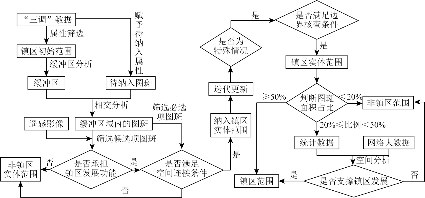
Abstract Scientifically and rationally demarcating urban and town areas is a fundamental task during China’s rapid urbanization stage. It serves as a critical basis for promoting the optimization and quality improvement of urban and rural spaces, scientifically coordinating urban and rural planning and construction management, and implementing territorial spatial planning. However, there is neither a unified concept nor a universal delimitation method for urban and town areas in China, hindering their planning, construction, development, and public management. Based on defining the relevant concepts of urban and town areas, this study proposed a people-centered method for determining town areas with no cities and counties set using geographic information system (GIS) technology, considering the characteristics and spatial relationships of land types. The data sources of this study include the results of the third national land resource survey, statistical bulletins, remote sensing image interpretation, and point-of-interest (POI) data. Finally, the proposed method was applied to demarcate the town areas in Xiapu County, Ningde City. The empirical study results demonstrate the effectiveness of the proposed method, which features a scientific and concise technology roadmap and strong operability. Therefore, the proposed method can provide a theoretical foundation for the rational territorial spatial planning.
|
| Keywords
town area
the third national land resource survey
point-of-interest (POI) data
geographic information system (GIS)
|
|
|
|
Issue Date: 03 September 2025
|
|
|
| [1] |
龙瀛, 吴康. 中国城市化的几个现实问题:空间扩张、人口收缩、低密度人类活动与城市范围界定[J]. 城市规划学刊, 2016,(2):72-77.
|
| [1] |
Long Y, Wu K. Several emerging issues of China’s urbanization:Spatial expansion,population shrinkage,low-density human activities and city boundary delimitation[J]. Urban Planning Forum, 2016,(2):72-77.
|
| [2] |
戚伟, 王开泳. 中国城市行政地域与实体地域的空间差异及优化整合[J]. 地理研究, 2019, 38(2):207-220.
doi: 10.11821/dlyj020180881
|
| [2] |
Qi W, Wang K Y. City administrative area and physical area in China:Spatial differences and integration strategies[J]. Geographical Research, 2019, 38(2):207-220.
|
| [3] |
汪阳. 我国城乡划分标准研究[D]. 成都: 西南交通大学, 2012.
|
| [3] |
Wang Y. Study on the criteria of urban-rural division in China[D]. Chengdu: Southwest Jiaotong University, 2012.
|
| [4] |
衣霄翔, 董慰, 张欢. 美国城市地区划定方法及其演变对我国的启示[J]. 国际城市规划, 2021, 36(1):69-75.
|
| [4] |
Yi X X, Dong W, Zhang H. Standards,methods and evolution of US urban area delineation:Fine delineation reflecting physical territory concept[J]. Urban Planning International, 2021, 36(1):69-75.
|
| [5] |
周一星, 史育龙. 建立中国城市的实体地域概念[J]. 地理学报, 1995, 50(4):289-301.
doi: 10.11821/xb199504001
|
| [5] |
Zhou Y X, Shi Y L. Toward establishing the concept of physical urban area in China[J]. Acta Geographica Sinica, 1995, 50(4):289-301.
doi: 10.11821/xb199504001
|
| [6] |
惠彦, 金志丰, 陈雯. 城乡地域划分和城镇人口核定研究——以常熟市为例[J]. 地域研究与开发, 2009, 28(1):42-46.
|
| [6] |
Hui Y, Jin Z F, Chen W. Study on urban-rural area division and urban population counting——The case of Changshu city[J]. Areal Research and Development, 2009, 28(1):42-46.
|
| [7] |
宋小冬, 柳朴, 周一星. 上海市城乡实体地域的划分[J]. 地理学报, 2006, 61(8):787-797.
|
| [7] |
Song X D, Liu P, Zhou Y X. Urban and rural area division:Taking Shanghai as an example[J]. Acta Geographica Sinica, 2006, 61(8):787-797.
doi: 10.11821/xb200608001
|
| [8] |
冯健. 城乡划分与监测[M]. 北京: 科学出版社, 2012.
|
| [8] |
Feng J. Urban and rural division and monitoring[M]. Beijing: Science Press, 2012.
|
| [9] |
徐强, 华晨. 城市建成区面积统计口径亟待统一——以杭州中心城区为例[J]. 规划师, 2005, 21(4):88-91.
|
| [9] |
Xu Q, Hua C. Establishing a uniform standard for calculation of urban built-up area—with Hangzhou central city zone as an example[J]. Planners, 2005, 21(4):88-91.
|
| [10] |
华晨, 洪祎丹, 王颖芳, 等. 城镇建成区概念与界定方法体系研究——以浙江德清市武康镇为例[J]. 城市规划学刊, 2013(2):57-62.
|
| [10] |
Hua C, Hong Y D, Wang Y F, et al. The concept and definition of urban built-up area:A case study of Wukang town in Zhejiang Province[J]. Urban Planning Forum, 2013(2):57-62.
|
| [11] |
胡忆东, 吴志华, 熊伟, 等. 城市建成区界定方法研究——以武汉市为例[J]. 城市规划, 2008, 32(4):88-91,96.
|
| [11] |
Hu Y D, Wu Z H, Xiong W, et al. Study on the definition method of urban built-up area—Taking Wuhan as an example[J]. City Planning Review, 2008, 32(4):88-91,96.
|
| [12] |
王浩, 刘娅菲, 宁晓刚, 等. 城区边界遥感提取研究进展[J]. 测绘科学, 2019, 44(6):159-165.
|
| [12] |
Wang H, Liu Y F, Ning X G, et al. Review on remote sensing extraction of urban boundary[J]. Science of Surveying and Mapping, 2019, 44(6):159-165.
|
| [13] |
陈洪, 陶超, 邹峥嵘, 等. 一种新的高分辨率遥感影像城区提取方法[J]. 武汉大学学报(信息科学版), 2013, 38(9):1063-1067.
|
| [13] |
Chen H, Tao C, Zou Z R, et al. Automatic urban area extraction using a Gabor filter and high-resolution remote sensing imagery[J]. Geomatics and Information Science of Wuhan University, 2013, 38(9):1063-1067.
|
| [14] |
周婕, 陈虹桔, 谢波. 基于多元数据的大都市区范围划定方法研究——以武汉为例[J]. 上海城市规划, 2017(2):70-75.
|
| [14] |
Zhou J, Chen H J, Xie B. Study on the method of metropolitan area delimitation based on multi-data:A case study of Wuhan[J]. Shanghai Urban Planning Review, 2017(2):70-75.
|
| [15] |
Wang H, Ning X, Zhang H, et al. Urban boundary extraction and urban sprawl measurement using high-resolution remote sensing images:A case study of China’s provincial capital[C]// International Archives of the Photogrammetry,Remote Sensing and Spatial Information Sciences, 2018.
|
| [16] |
Zhang X, Du S, Wang Q. Integrating bottom-up classification and top-down feedback for improving urban land-cover and functional-zone mapping[J]. Remote Sensing of Environment, 2018, 212:231-248.
|
| [17] |
周小驰, 刘咏梅, 杨海娟. 西安市城市边缘区空间识别与边界划分[J]. 地球信息科学学报, 2017, 19(10):1327-1335.
doi: 10.3724/SP.J.1047.2017.01327
|
| [17] |
Zhou X C, Liu Y M, Yang H J. Spatial recognition and boundary region division of urban fringe area in Xi’an City[J]. Journal of Geo-Information Science, 2017, 19(10):1327-1335.
|
| [18] |
袁于评, 花益平, 薛星宇, 等. 多源遥感数据的城市边界提取及动态变化研究[J]. 测绘科学, 2022, 47(2):110-116.
|
| [18] |
Yuan Y P, Hua Y P, Xue X Y, et al. Urban boundary extraction and dynamic change based on multisource remote sensing data[J]. Science of Surveying and Mapping, 2022, 47(2):110-116.
|
| [19] |
王德, 顾家焕, 晏龙旭. 上海都市区边界划分——基于手机信令数据的探索[J]. 地理学报, 2018, 73(10):1896-1909.
doi: 10.11821/dlxb201810006
|
| [19] |
Wang D, Gu J H, Yan L X. Delimiting the Shanghai metropolitan area using mobile phone data[J]. Acta Geographica Sinica, 2018, 73(10):1896-1909.
doi: 10.11821/dlxb201810006
|
| [20] |
方斌, 张宪哲, 杨柳. 基于POI数据的城市边界变化提取研究——以山西运城市城区为例[J]. 现代测绘, 2017, 40(5):20-22.
|
| [20] |
Fang B, Zhang X Z, Yang L. Study on urban boundary identification based on POI:A case study of Yuncheng City in Shanxi[J]. Modern Surveying and Mapping, 2017, 40(5):20-22.
|
| [21] |
许泽宁, 高晓路. 基于电子地图兴趣点的城市建成区边界识别方法[J]. 地理学报, 2016, 71(6):928-939.
doi: 10.11821/dlxb201606003
|
| [21] |
Xu Z N, Gao X L. A novel method for identifying the boundary of urban built-up areas with POI data[J]. Acta Geographica Sinica, 2016, 71(6):928-939.
doi: 10.11821/dlxb201606003
|
| [22] |
伍江, 刘春, 应申, 等. 城区范围空间划定方法研究[J]. 自然资源遥感, 2021(4):89-97.doi:10.6046/zrzyyg.2021015.
|
| [22] |
Wu J, Liu C, Ying S, et al. Spatial delineation methods of urban areas[J]. Remote Sensing for Natural Resources, 2021(4):89-97.doi:10.6046/zrzyyg.2021015.
|
| [23] |
张欢, 赵志庆, 陈玉珠. 国土空间规划中城区范围划定方法、条件及流程初探——以江西省景德镇市为例[J]. 城市规划学刊, 2020(4):51-57.
|
| [23] |
Zhang H, Zhao Z Q, Chen Y Z. A preliminary study on method,condition and procedure of urban area identification under the background of territorial development planning:Taking Jingdezhen of Jiangxi Province as an example[J]. Urban Planning Forum, 2020(4):51-57.
|
| [24] |
徐浩, 王炜文. 新时期新规划体系下的镇区范围识别研究——以晋江市安海镇为例[C]// 中国城市规划学会.人民城市,规划赋能——2022中国城市规划年会论文集(20总体规划). 广州市: 广州市城市规划勘测设计研究院, 2023: 9.
|
| [24] |
Xu H, Wang W W. Research on the identification of town area scope under the new planning system in the new era——taking Anhai Town of Jinjiang City as an example[C]// Urban Planning Society of China.People’s City,Planning Empowerment——Proceedings of the 2022 China Urban Planning Annual Conference (20 Master Planning). Guangzhou: Guangzhou Urban Planning, Survey and Design Institute, 2023: 9.
|
| [25] |
国家统计局. 统计上划分城乡的规定[EB/OL]. https://www.stats.gov.cn/sj/tjbz/gjtjbz/202302/t20230213_1902742.html.
url: https://www.stats.gov.cn/sj/tjbz/gjtjbz/202302/t20230213_1902742.html
|
| [25] |
National Bureau of Statistics. Provisions for the statistical division of urban and rural areas[EB/OL]. https://www.stats.gov.cn/sj/tjbz/gjtjbz/202302/t20230213_1902742.html.
url: https://www.stats.gov.cn/sj/tjbz/gjtjbz/202302/t20230213_1902742.html
|
| [26] |
国家统计局. 城市(县城)和村镇建设统计调查制度[EB/OL]. https://www.stats.gov.cn/fw/bmdcxmsp/bmzd/202302/t20230215_1907097.html.
url: https://www.stats.gov.cn/fw/bmdcxmsp/bmzd/202302/t20230215_1907097.html
|
| [26] |
National Bureau of Statistics. Urban (county) and rural areas construction statistical survey system[EB/OL]. https://www.stats.gov.cn/fw/bmdcxmsp/bmzd/202302/t20230215_1907097.html.
url: https://www.stats.gov.cn/fw/bmdcxmsp/bmzd/202302/t20230215_1907097.html
|
| [27] |
国务院. 国务院关于调整城市规模划分标准的通知[EB/OL]. http://www.gov.cn/zhengce/content/2014-11/20/content_9225.htm.
url: http://www.gov.cn/zhengce/content/2014-11/20/content_9225.htm
|
| [27] |
The State Council. Notice of the State Council on readjustment of the standards for the division of urban dimensions[EB/OL]. http://www.gov.cn/zhengce/content/2014-11/20/content_9225.htm.
url: http://www.gov.cn/zhengce/content/2014-11/20/content_9225.htm
|
| [28] |
中华人民共和国建设部. GB/T 50280—1998 城市规划基本术语标准[S]. 北京: 中国建筑工业出版社, 1999.
|
| [28] |
Ministry of Construction of the People’s Republic of China. GB/T 50280—1998 Standard for basic terminology of urban planning[S]. Beijing: China Architecture Publishing, 1999.
|
| [29] |
中华人民共和国自然资源部. TD/T 1063—2021 国土空间规划城市体检评估规程[S]. 北京: 地质出版社, 2021.
|
| [29] |
Ministry of Natural Resources of the People’s Republic of China. TD/T 1063—2021 Code of practice for city examination & evaluation in spatial planning[S]. Beijing: Geological Publishing House, 2021.
|
| [30] |
王继龙, 林丰增, 彭博, 等. 东南沿海火山岩区城镇建设适宜性评价与实践——以福建省宁德市为例[J]. 华东地质, 2022, 43(4):490-502.
|
| [30] |
Wang J L, Lin F Z, Peng B, et al. Evaluation and practice of urban construction suitability in coastal volcanic areas of southeast China:A case study of Ningde City,Fujian Province[J]. East China Geology, 2022, 43(4):490-502.
|
| [31] |
张定源, 张景, 牛晓楠, 等. 双评价理论探索与福建实践[J]. 华东地质, 2021, 42(4):419-428.
|
| [31] |
Zhang D Y, Zhang J, Niu X N, et al. Exploration on dual evaluation theory and the practice in Fujian Province[J]. East China Geology, 2021, 42(4):419-428.
|
| [32] |
国务院第三次全国国土调查领导小组办公室. 国务院第三次全国国土调查领导小组办公室关于印发《第三次全国国土调查实施方案》的通知[EB/OL]. http://gi.mnr.gov.cn/201811/t20181120_2367135.html.
url: http://gi.mnr.gov.cn/201811/t20181120_2367135.html
|
| [32] |
Office of the Third National Land Survey. Notice of the office of the third national land survey on the issuance of the implementation plan for the third national land survey[EB/OL]. http://gi.mnr.gov.cn/201811/t20181120_2367135.html.
url: http://gi.mnr.gov.cn/201811/t20181120_2367135.html
|
| [33] |
中国国土勘测规划院, 自然资源部自然资源调查监测司.TD/T1055—2019 第三次全国国土调查技术规程[S]. 北京: 地质出版社, 2019.
|
| [33] |
Chinese Land Surveying and Planning Institute,Division of Natural Resources Survey and Monitoring,Ministry of Natural Resources. TD/T 1055—2019 Technical regulations for the third national land survey[S]. Beijing: Geological Publishing House, 2019.
|
| [34] |
林丰增. 新时期市级国土空间总体规划编制认识与思考——以福建省宁德市为例[J]. 华东地质, 2021, 42(4):409-418.
|
| [34] |
Lin F Z. Understanding and thinking on formulating overall planning of municipal territorial space in the new era:A case study of Ningde City,Fujian Province[J]. East China Geology, 2021, 42(4):409-418.
|
|
Viewed |
|
|
|
Full text
|
|
|
|
|
Abstract
|
|
|
|
|
Cited |
|
|
|
|
| |
Shared |
|
|
|
|
| |
Discussed |
|
|
|
|
 2025,
Vol. 37
2025,
Vol. 37