Please wait a minute...
 
国土资源遥感  2018, Vol. 30 Issue (3): 60-67    DOI: 10.6046/gtzyyg.2018.03.09
     本期目录 | 过刊浏览 | 高级检索 |
基于像元转换的土地覆盖变化监测方法——以北京市区县为例
于冰1,2, 王继燕1, 苏勇1, 肖东升1, 刘福臻1
1. 西南石油大学土木工程与建筑学院,成都 610500
2. 东华理工大学江西省数字国土重点实验室,南昌 330013
A pixel transform-based land cover change detection approach: A case study of Beijing City
Bing YU1,2, Jiyan WANG1, Yong SU1, Dongsheng XIAO1, Fuzhen LIU1
1. School of Civil Engineering and Architecture, Southwest Petroleum University, Chengdu 610500, China
2. The Key Laboratory for Digital Land and Resources of Jiangxi Province, East China University of Technology, Nanchang 330013, China
全文: PDF(4181 KB)   HTML  
输出: BibTeX | EndNote (RIS)      
摘要 

叠置像元比较分析方法常用于遥感分类后土地利用/土地覆盖变化检测,该方法通过栅格数据计算实现,方便快捷。提出一种利用像元转换的变化检测方法,结合ArcGIS软件平台,实现了对不同区域的土地覆盖类别变化分析的一体化处理方式。该方法是叠合像元比较方法的一种扩展,能对具有多类别的覆盖场景进行同步变化检测,依据新定义的覆盖类别编码,将不同时相的土地覆盖图进行叠置分析或分区统计分析,从而统计不同范围中各覆盖类别的定量转化及发生转化的空间分布。实验以2期北京市GlobeLand30数据为对象,利用新检测方法对不同范围和覆盖类别变化进行了计算,更为高效快捷地获得了变化结果,展示了覆盖类别变化和景观格局变化,验证了该变化检测方法的适用性。

服务
把本文推荐给朋友
加入引用管理器
E-mail Alert
RSS
作者相关文章
于冰
王继燕
苏勇
肖东升
刘福臻
关键词 GlobeLand30土地覆盖变化类别转化时空变化驱动力    
Abstract

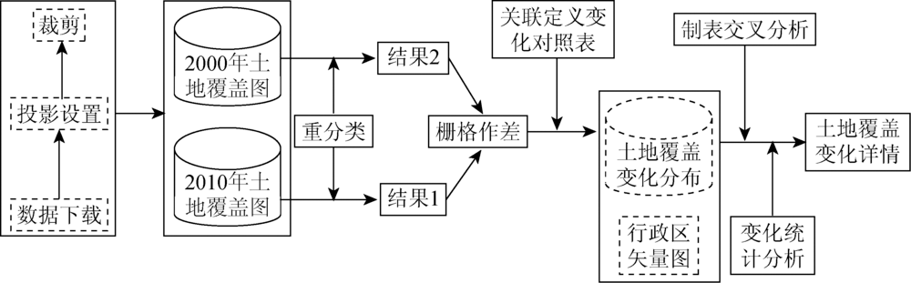
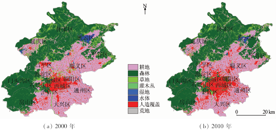
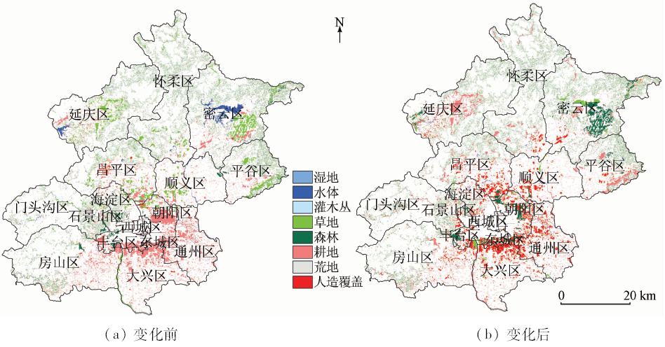
Pixel overlay and comparative methods have been widely used to detect land use/ cover change. In view of such a situation, the authors propose a pixel transform-based change detection method for land cover data in this study. This method is an extended method of pixel overlay analysis, and it supports change detection of diverse land cover types synchronously for different time phases. According to the re-definition of the type code and through map overlay analysis and zone statistical analysis for different phases of land cover maps, the authors quantified every cover changes and displayed the changes spatial distribution. Taking two phases data of Beijing in 2000 and 2010 as a study case, the authors applied this detection method for different categories of land cover with different ranges. The results show more accuracy land cover classes change, and the practicability and applicability of the extended change detection method are accordingly verified.

Key wordsGlobeLand30    land cover change    conversion of the land use types    spatial and temporal changes    driving force
收稿日期: 2017-03-27      出版日期: 2018-09-10
:  TP79  
基金资助:西南石油大学“过学术关”资助计划项目“高分辨率遥感地表变化及形变监测”(201599010140);东华理工大学江西省数字国土重点实验室开放研究基金项目“基于高分辨率时序差分雷达干涉的平原城市大梯度沉降监测与分析”(DLLJ201712)
作者简介: 于 冰(1985-),男,博士,主要从事遥感全球变化监测及雷达干涉的理论和应用研究。Email: rs_insar_bingyu@163.com。
引用本文:   
于冰, 王继燕, 苏勇, 肖东升, 刘福臻. 基于像元转换的土地覆盖变化监测方法——以北京市区县为例[J]. 国土资源遥感, 2018, 30(3): 60-67.
Bing YU, Jiyan WANG, Yong SU, Dongsheng XIAO, Fuzhen LIU. A pixel transform-based land cover change detection approach: A case study of Beijing City. Remote Sensing for Land & Resources, 2018, 30(3): 60-67.
链接本文:  
https://www.gtzyyg.com/CN/10.6046/gtzyyg.2018.03.09      或      https://www.gtzyyg.com/CN/Y2018/V30/I3/60
编码 地类
耕地 森林 草地 灌木丛 湿地 水体 苔原 人造覆盖 荒地 永久冰雪
原编码值 10 20 30 40 50 60 70 80 90 100
新编码值 20 21 22 23 24 25 26 27 28 29
Tab.1  覆盖类别新旧对照
Fig.1  数据处理流程
2000年 2010年
人造覆盖 荒地 耕地 森林 草地 灌木丛 永久冰雪 苔原 水体 湿地
人造覆盖 0 128 -127 -126 -124 -120 384 -64 -96 -112
荒地 -128 0 -255 -254 -252 -248 256 -192 -224 -240
耕地 127 255 0 1 3 7 511 63 31 15
森林 126 254 -1 0 2 6 510 62 30 14
草地 124 252 -3 -2 0 4 508 60 28 12
灌木丛 120 248 -7 -6 -4 0 504 56 24 8
永久冰雪 -384 -256 -511 -510 -508 -504 0 -448 -480 -496
苔原 64 192 -63 -62 -60 -56 448 0 -32 -48
水体 96 224 -31 -30 -28 -24 480 32 0 -16
湿地 112 240 -15 -14 -12 -8 496 48 16 0
Tab.2  类别变化唯一值对照表
Fig.2  研究区范围
年份 地类
人造覆盖 荒地 耕地 森林 草地 灌木丛 水体 湿地
2000年 2 696.012 0.313 9 562.246 12 177.783 2 951.141 0.439 441.130 15.264
2010年 3 800.504 0.436 9 011.259 12 502.897 2 252.095 0.408 260.542 16.192
Tab.3  北京市2期数据土地覆盖数据
Fig.3  北京市单一土地利用动态度
地类 人造覆盖 荒地 耕地 森林 草地 灌木丛 水体 湿地
人造覆盖 0.000 9 174.408 0 23.158 8 5.224 5 0.00 10.428 3 0.201 6
荒地 0.002 7 0.047 7 0.009 0 0.179 1 0.00 0.001 8 0.00
耕地 963.838 0 0.072 9 236.381 0 119.248 0 0.000 9 33.788 7 1.883 7
森林 87.159 6 0.014 4 105.224 0 517.523 0 0.204 3 4.984 2 0.109 8
草地 257.414 0 0.228 6 436.961 0 721.276 0 0.127 8 13.760 1 2.502 0
灌木丛 0.00 0.00 0.002 7 0.291 6 0.070 2 0.00 0.00
水体 11.457 9 0.034 2 85.049 1 56.625 3 82.207 8 0.00 10.867 5
湿地 0.353 7 0.00 6.468 3 1.178 1 4.200 3 0.00 2.438 1
Tab.4  北京市类别变化转移矩阵
Fig.4  北京市10 a间土地覆盖类别转移变化
Fig.5  北京市人造覆盖区域扩张变化分布
年份 NP LPI PR AI
2000年 88 610 35.529 7 8 95.267 1
2010年 86 057 35.781 5 8 95.470 3
Tab.5  2期数据景观指数
Fig.6  各辖区2期数据土地覆盖类别空间分布
辖区 人造覆盖 荒地 耕地 森林 草地 灌木丛 水体 湿地
东城区 2.11 0.00 -98.78 9.46 0.00 0.00 -8.20 0.00
丰台区 35.79 0.00 -72.71 23.14 38.20 0.00 30.68 0.00
大兴区 84.91 0.00 -15.96 0.00 -29.77 0.00 38.30 0.00
密云区 26.46 0.00 -0.76 12.57 -16.50 0.00 -50.24 457.93
平谷区 36.29 0.00 9.43 1.21 -37.19 0.00 -15.86 0.00
延庆区 25.16 0.00 19.48 0.95 -25.14 0.00 -66.57 -33.58
怀柔区 47.07 0.00 10.85 0.06 -14.73 0.00 -22.02 0.00
房山区 33.35 0.00 -6.94 -0.26 -9.45 -38.10 8.04 0.00
昌平区 49.48 0.00 -1.96 0.95 -36.97 0.00 -17.80 138.54
朝阳区 31.35 0.00 -49.14 7 411.36 -75.20 0.00 -7.66 0.00
海淀区 19.84 0.00 -4.26 -14.08 -32.41 0.00 -3.32 0.00
石景山区 20.93 0.00 -23.06 -22.81 0.76 0.00 -18.72 0.00
西城区 0.26 0.00 -100.00 1 109.09 0.00 0.00 -10.41 0.00
通州区 76.40 0.00 -13.86 0.00 -37.08 0.00 7.97 -73.70
门头沟区 91.07 0.00 14.10 -0.76 -13.73 -5.83 -49.03 0.00
顺义区 38.89 0.00 -1.15 -1.41 -73.04 0.00 -52.82 -50.72
Tab.6  北京市各辖区类别变化统计
[1] 陈怀亮, 徐祥德, 刘玉洁 . 土地利用与土地覆盖变化的遥感监测及环境影响研究综述[J]. 气象科技, 2005,33(4):289-294.
doi: 10.3969/j.issn.1671-6345.2005.04.001
Chen H L, Xu X D, Liu Y J . Review of researches on remote sensing monitoring and impact on environment of land use/cover change[J]. Meteorological Science and Technology, 2005,33(4):289-294.
[2] 刘美玲, 齐清文, 邹秀萍 , 等. 基于RS对云南边境地区土地覆盖现状及变化研究[J]. 国土资源遥感, 2006,18(1):75-78.doi: 10.6046/gtzyyg.2006.01.17.
doi: 10.6046/gtzyyg.2006.01.17
Liu M L, Qi Q W, Zou X P , et al. Spatial-temporal changes of the land use/cover in border areas of Yunnan Province[J]. Remote Sensing for Land and Resources, 2006,18(1):75-78.doi: 10.6046/gtzyyg.2006.01.17.
[3] Harris P M, Ventura S J . The integration of geographic data with remotely sensed imagery to improve classification in an urban area[J]. Photogrammetric Engineering and Remote Sensing, 1995,61(8):993-998.
[4] Green K, Kempka D, Lackey L . Using remote sensing to detect and monitor land-cover and land-use change[J]. Photogrammetric Engineering and Remote Sensing, 1994,60(3):331-337.
doi: 10.1002/ima.1850050109
[5] Coppin P, Jonckheere I, Nackaerts K , et al. Digital change detection methods in ecosystem monitoring:A review[J]. International Journal of Remote Sensing, 2004,25(9):1565-1596.
doi: 10.1080/0143116031000101675
[6] Giri C, Pengra B, Zhu Z L , et al. Monitoring mangrove forest dynamics of the Sundarbans in Bangladesh and India using multi-temporal satellite data from 1973 to 2000[J]. Estuarine,Coastal and Shelf Science, 2007,73(1/2):91-100.
doi: 10.1016/j.ecss.2006.12.019
[7] Masek J G, Huang C Q, Wolfe R , et al. North American forest disturbance mapped from a decadal Landsat record[J]. Remote Sensing of Environment, 2008,112(6):2914-2926.
doi: 10.1016/j.rse.2008.02.010
[8] Xian G, Homer C, Fry J . Updating the 2001 national land cover database land cover classification to 2006 by using Landsat imagery change detection methods[J]. Remote Sensing of Environment, 2009,113(6):1133-1147.
doi: 10.1016/j.rse.2009.02.004
[9] 杜培军, 柳思聪, 郑辉 . 基于支持向量机的矿区土地覆盖变化检测[J]. 中国矿业大学学报, 2012,41(2):262-267.
Du P J, Liu S C, Zheng H . Land cover change detection over mining areas based on support vector machine[J]. Journal of China University of Mining and Technology, 2012,41(2):262-267.
[10] 王丽云, 李艳, 汪禹芹 . 基于对象变化矢量分析的土地利用变化检测方法研究[J]. 地球信息科学学报, 2014,16(2):307-313.
doi: 10.3724/SP.J.1047.2014.00307
Wang L Y, Li Y, Wang Y Q . Research on land use change detection based on an object-oriented change vector analysis method[J]. Journal of Geo-information Science, 2014,16(2):307-313.
[11] 王琰 . 基于像斑统计分析的高分辨率遥感影像土地利用/覆盖变化检测方法研究[D]. 武汉:武汉大学, 2012.
Wang Y . The Research of Land Use/Cover Change Detection Using High Resolution Remote Sensing Images Based on Image Segments Statistical Analysis[D]. Wuhan:Wuhan University, 2012.
[12] 宋翔, 颜长珍 . 基于知识库的像斑光谱向量相似度土地覆盖变化检测方法[J]. 生态学报, 2014,34(24):7175-7180.
doi: 10.5846/stxb201310132458
Song X, Yan C Z . Land cover change detection using segment similarity of spectrum vector based on knowledge base[J]. Acta Ecologica Sinica, 2014,34(24):7175-7180.
[13] El-Gamily H I . Utilization of multi-dates LANDSAT_TM data to detect and quantify the environmental damages in the southeastern region of Kuwait from 1990 to 1991[J]. International Journal of Remote Sensing, 2007,28(8):1773-1788.
doi: 10.1080/01431160600784275
[14] 李静, 吴连喜, 周珏 . 遥感变化检测技术发展综述[J]. 水利科技与经济, 2007,13(3):153-155.
Li J, Wu L X, Zhou Y . Review of the development of remote sensing change detection technology[J]. Water Conservancy Science and Technology and Economy, 2007,13(3):153-155.
[15] 张学, 童小华, 刘妙龙 . 一种扩展的土地覆盖转换像元变化检测方法[J]. 同济大学学报(自然科学版), 2009,37(5):685-689.
doi: 10.1042/BSR20080061
Zhang X, Tong X H, Liu M L . An extended dectection method for land cover transformation[J]. Journal of Tongji University(Natural Science), 2009,37(5):685-689.
[16] 唐朴谦, 杨建宇, 张超 , 等. 基于像素比值的面向对象分类后遥感变化检测方法[J].遥感信息, 2010(1):69-72.
doi: 10.3969/j.issn.1000-3177.2010.01.014
Tang P Q, Yang J Y, Zhang C , et al. An object-oriented post-classification remote sensing change detection after the pixel ratio[J].Remote Sensing Information, 2010(1):69-72.
[17] Ridding L E, Redhead J W, Pywell R F . Fate of semi-natural grassland in England between 1960 and 2013:A test of national conservation policy[J]. Global Ecology and Conservation, 2015,4:516-525.
doi: 10.1016/j.gecco.2015.10.004
[18] 王秀兰, 包玉海 . 土地利用动态变化研究方法探讨[J]. 地理科学进展, 1999,18(1):81-87.
doi: 10.3969/j.issn.1007-6301.1999.01.012
Wang X L, Bao Y H . Study on the methods of land use dynamic change research[J]. Progress in Geography, 1999,18(1):81-87.
[19] 刘灿然, 陈灵芝 . 北京地区植被景观中斑块大小的分布特征[J]. 植物学报, 1999,41(2):199-205.
Liu C R, Chen L Z . Distribution characteristics of patch size in the vegetation landscape in Beijing[J]. Acta Botanica Sinica, 1999,41(2):199-205.
[20] 曾春阳, 曾广宇, 程丽华 , 等. 林地变化及景观斑块特征的演变[J]. 中南林业科技大学学报, 2012,32(8):33-36,41.
Zeng C Y, Zeng G Y, Cheng L H , et al. Analysis of change and patch landscape characteristics of forestland[J]. Journal of Central South University of Forestry and Technology, 2012,32(8):33-36,41.
[21] Yu X J, Ng C N . Spatial and temporal dynamics of urban sprawl along two urban-rural transects:A case study of Guangzhou,China[J]. Landscape and Urban Planning, 2007,79(1):96-109.
doi: 10.1016/j.landurbplan.2006.03.008
[22] Jun C, Ban Y F, Li S N . China:Open access to Earth land-cover map[J]. Nature, 2014,514(7523):434.
doi: 10.1038/514434c pmid: 25341776
[23] 陈军, 陈晋, 廖安平 , 等. 全球30 m地表覆盖遥感制图的总体技术[J]. 测绘学报, 2014,43(6):551-557.
doi: 10.13485/jc.nki1.1-20892.0140.089
Chen J, Chen J, Liao A P , et al. Concepts and key techniques for 30 m global land cover mapping[J]. Acta Geodaetica et Cartographica Sinica, 2014,43(6):551-557.
[24] 顾朝林 . 北京土地利用/覆盖变化机制研究[J]. 自然资源学报, 1999,14(4):307-312.
doi: 10.11849/zrzyxb.1999.04.003
Gu C L . Study on phenomena and mechanism of land use/cover change in Beijing[J]. Journal of Natural Resources, 1999,14(4):307-312.
[1] 胡盈盈, 戴声佩, 罗红霞, 李海亮, 李茂芬, 郑倩, 禹萱, 李宁. 2001—2015年海南岛橡胶林物候时空变化特征分析[J]. 自然资源遥感, 2022, 34(1): 210-217.
[2] 范田亿, 张翔, 黄兵, 钱湛, 姜恒. 湘江流域TRMM卫星降水产品降尺度研究与应用[J]. 自然资源遥感, 2021, 33(4): 209-218.
[3] 晋成名, 杨兴旺, 景海涛. 基于RS的陕北地区植被覆盖度变化及驱动力研究[J]. 自然资源遥感, 2021, 33(4): 258-264.
[4] 杨蕴雪, 张艳芳. 基于空间距离指数的延河流域生态敏感性时空演变特征[J]. 自然资源遥感, 2021, 33(3): 229-237.
[5] 郝固状, 甘甫平, 闫柏琨, 李贤庆, 胡辉东. 红崖山水库近20年面积变化遥感调查及驱动力分析[J]. 国土资源遥感, 2021, 33(2): 192-201.
[6] 叶婉桐, 陈一鸿, 陆胤昊, 吴鹏海. 基于GEE的2000—2019年间升金湖湿地不同季节地表温度时空变化及地表类型响应[J]. 国土资源遥感, 2021, 33(2): 228-236.
[7] 陈虹, 郭兆成, 贺鹏. 1988—2018年间洱海流域植被覆盖度时空变换特征探究[J]. 国土资源遥感, 2021, 33(2): 116-123.
[8] 胡苏李扬, 李辉, 顾延生, 黄咸雨, 张志麒, 汪迎春. 基于高分辨率遥感影像的神农架大九湖湿地土地利用类型变化及其驱动力分析——来自长时间尺度多源遥感信息的约束[J]. 国土资源遥感, 2021, 33(1): 221-230.
[9] 潘梦, 曹云刚. 高亚洲地区冰湖遥感研究进展与展望[J]. 国土资源遥感, 2021, 33(1): 1-8.
[10] 王平, 毛克彪, 孟飞, 袁紫晋. 中国东海海表温度时空演化分析[J]. 国土资源遥感, 2020, 32(4): 227-235.
[11] 赵冰, 毛克彪, 蔡玉林, 孟祥金. 中国地表温度时空演变规律研究[J]. 国土资源遥感, 2020, 32(2): 233-240.
[12] 王伟, 阿里木·赛买提, 吉力力·阿不都外力. 基于地理探测器模型的中亚NDVI时空变化特征及其驱动因子分析[J]. 国土资源遥感, 2019, 31(4): 32-40.
[13] 韩红珠, 白建军, 张波, 马高. 基于MODIS时序的陕西省植被物候时空变化特征分析[J]. 国土资源遥感, 2018, 30(4): 125-131.
[14] 杨敏, 杨贵军, 王艳杰, 张勇峰, 张智宏, 孙晨红. 北京城市热岛效应时空变化遥感分析[J]. 国土资源遥感, 2018, 30(3): 213-223.
[15] 戴晨曦, 谢相建, 徐志刚, 杜培军. 中草药材种植遥感监测与分析——以云南省文山和红河地区三七种植为例[J]. 国土资源遥感, 2018, 30(1): 210-216.
Viewed
Full text


Abstract

Cited

  Shared   
  Discussed   
京ICP备05055290号-2
版权所有 © 2015 《自然资源遥感》编辑部
地址:北京学院路31号中国国土资源航空物探遥感中心 邮编:100083
电话:010-62060291/62060292 E-mail:zrzyyg@163.com
本系统由北京玛格泰克科技发展有限公司设计开发