Temporal-spatial evolutionary characteristics of ecological sensitivity in Yanhe River basin based on spatial distance index
YANG Yunxue1,2(), ZHANG Yanfang1,2()
1. School of Geography and Tourism, Shaanxi Normal University, Xi’an 710119, China 2. National Experimental Teaching Demonstration Center of Geography, Shaanxi Normal University, Xi’an 710119, China
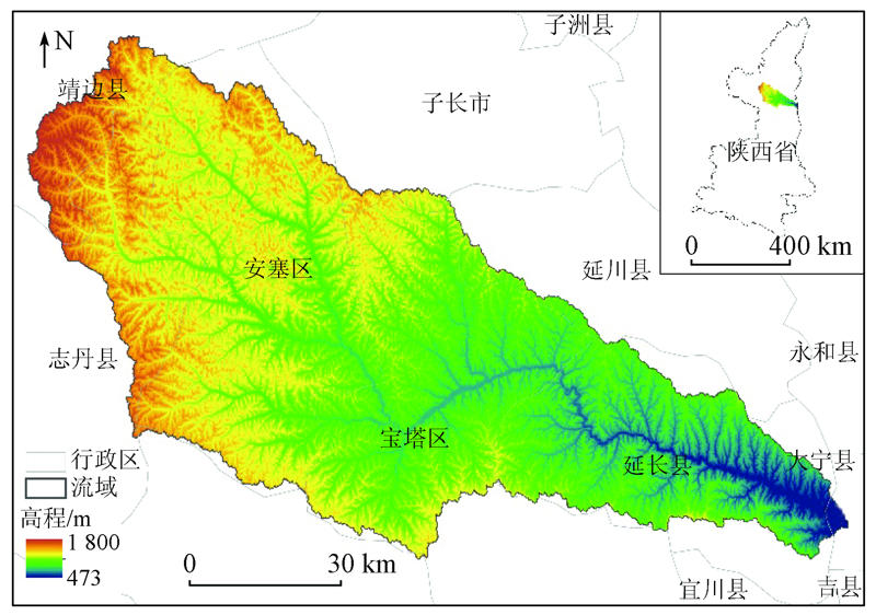
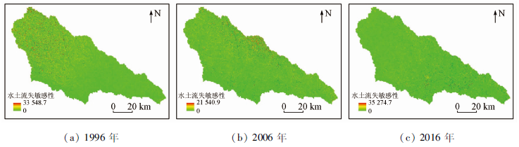
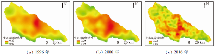
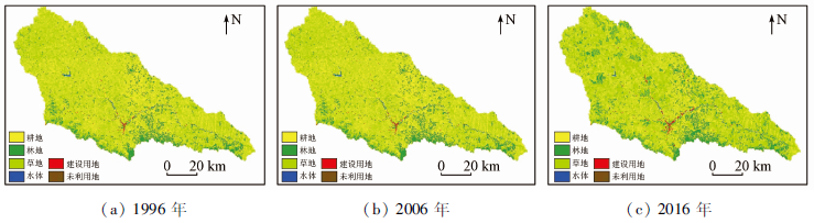
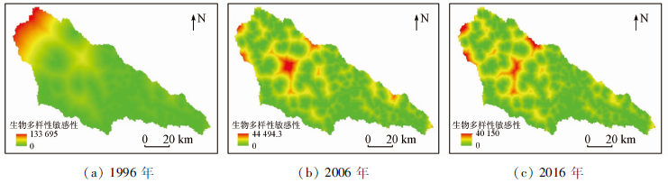
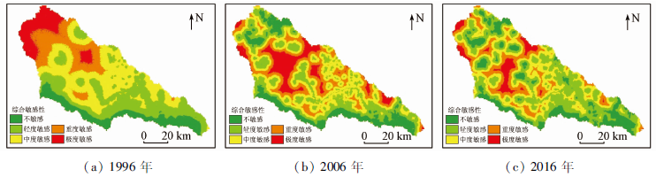
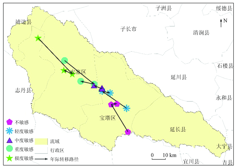
Ecological sensitivity refers to the sensitive degree of an ecosystem to the changes in the natural environment and the interference of human activities. It can be used to reflect the liable degree and possibility of the occurrence of ecological environmental problems. Taking the Yanhe River basin in the loess hilly and gully region as an example, this study selected three quantitative assessment indicators (i.e., sensitivity indices of soil erodibility, ecological risks, and biodiversity) to construct a composite environmental sensitivity index (CESI) based on spatial distance index for a river basin. Then it explored the temporal-spatial changes in the ecological sensitivity of the Yanhe River basin during 1996—2016 by combining the center of gravity model, obtaining the following results. ①From the perspective of temporal change, the ecological sensitivity in the Yanhe River basin during 1996—2016 showed a downward trend, with CESI increasing from 1.38 in 1996 to 1.41 in 2016. This indicates that the quality of the ecological environment in the Yanhe River basin improved during the period. ② From the perspective of spatial change, the spatial distribution of the ecological sensitivity in the Yanhe River basin greatly changed during 1996—2016. In detail, the areas with high ecological sensitivity were concentrated in the upper reaches in 1996 but were mainly distributed in the middle and lower reaches after 2006. ③ The center of gravity of the ecologically sensitive areas at all levels shifted toward the middle reaches during 1996—2016. Meanwhile, the ecologically sensitive areas were distributed in a concentrated way in 1996 but in a both concentrated and dispersed manner in 2016. ④ The ecological sensitivity in the Yanhe River basin was greatly affected by land use. The project of returning farmland to forest (grass) and comprehensive management project in the Yanhe River basin played a key role in the process of reducing ecological sensitivity.
杨蕴雪, 张艳芳. 基于空间距离指数的延河流域生态敏感性时空演变特征[J]. 自然资源遥感, 2021, 33(3): 229-237.
YANG Yunxue, ZHANG Yanfang. Temporal-spatial evolutionary characteristics of ecological sensitivity in Yanhe River basin based on spatial distance index. Remote Sensing for Natural Resources, 2021, 33(3): 229-237.
Xu Y, Gao J F, Zhao J H, et al. The research progress and prospect of watershed ecological risk assessment[J]. Acta Ecologica Sinica, 2012, 32(1):284-292.
doi: 10.5846/stxb
Zhang G C, Wang J, Liu D W, et al. Analysis and evaluation of the ecological sensitivity in the middle reaches of the Syr Darya River based on GIS[J]. Arid Zone Research, 2020, 37(2):506-513.
Li Z Y, Wei W, Zhou L, et al. Temporal and spatial evolution of ecological sensitivity in arid inland river basins of northwest China based on spatial distance index:A case study of Shiyang River Basin[J]. Acta Ecologica Sinica, 2019, 39(20):7463-7475.
Li Y M, Guan C W, Zhu J. GIS-based ecologocal sensitivity analysis in Xingyun Lake Basin[J]. Research of Soil and Water Conservation, 2017, 24(5):266-271,278.
Zhong L S, Tang C C, Guo H. Tourism function zoning of Jinyintan grassland scenic area in Qinghai Province based on ecological sensitivity analysis[J]. Chinese Journal of Applied Ecology, 2010, 21(7):1813-1819.
Liu C X, Li Y C, Yang H, et al. RS and GIS-based assessment for eco-environmental sensitivity of the Three Gorges Reservoir area of Chongqing[J]. Acta Geographica Sinica, 2011, 66(5):631-642.
Du T F, Qi W, Zhu X C, et al. Precise identification and control method of natural resources space based on ecological security pattern in mountainous hilly area[J]. Journal of Natural Resources, 2020, 35(5):1190-1200.
doi: 10.31497/zrzyxb.20200514
Wang Y Z, Duan X J. Ecological red line demarcation method and its application in the Yangtze River coastline[J]. Resources and Environment in the Yangtze Basin, 2019, 28(11):2681-2690.
Wei W, Shi P J, Zhou J J, et al. Land ecological sensitivity evaluation of Shiyang River basin based on zonal statistics[J]. Research of Soil and Water Conservation, 2015, 22(6):240-244.
Wang J, Cheng W M, Qi S L, et al. Sensitive evaluation and spatial analysis of soil and water loss based on USLE and GIS:Taking Taihang Mountain area of Hebei Province as an example[J]. Geographical Research, 2014, 33(4):614-624.
Qin W, Zhu Q K, Zhang Y. Soil erosion assessment of small watershed in Loess Plateau based on GIS and RUSLE[J]. Transactions of the Chinese Society of Agricultal Engineering, 2009, 25(8):157-163.
Xu L, Luo W, Zhou B T. Landscape ecological risk assessment of farming-pastoral ecozone based on land use change:A case study of the Yanghe Watershed,China[J]. Journal of Natural Resources, 2015, 30(4):580-590.
Fu L H, Xie B G, Zhang Y, et al. Ecological risk assessment of land use in core area of Changsha-Zhuzhou-Xiangtan urban group[J]. Journal of Natural Disasters, 2011, 20(2):96-101.
Huang M Y, He X. Landscape ecological risk assessment and its mechanism in Chaohu Basin during the past almost 20 years[J]. Journal of Lake Science, 2016, 28(4):785-793.
Duan Y F, Ren Z Y, Zhou X, et al. Spatio-temporal variation in the land ecological risk of Yan’an City[J]. Remote Sensing for Land and Resources, 2020, 32(1):120-129.doi: 10.6046/gtzyyg.2020.01.17.
doi: 10.6046/gtzyyg.2020.01.17
Ma C H. Assessment on spatiotemporal ecological risk in loess highland region of Shaanxi Province[J]. Research of Soil and Water Conservation, 2014, 21(5):216-220.
Liu X Z, Li X S, Han X T, et al. Research on diagnosis of resource-based urban landscape safety pattern based on MCR model:A case study of Xuzhou City[J]. Ecological Economy, 2020, 36(6):221-229.
Huang M Y, Yue W Z, Feng S R, et al. Analysis of spatial heterogeneity of ecological security based on MCR model and ecological pattern optimization in the Yuexi County of the Dabie Mountain Area[J]. Journal of Natural Resources, 2019, 34(4):771-784.
doi: 10.31497/zrzyxb.20190408
[25]
俞孔坚. 生物保护的景观生态安全格局[J]. 生态学报, 1999, 19(1):8-15.
Yu K J. Landscape ecological security patterns in biological conservation[J]. Acta Ecologica Sinica, 1999, 19(1):8-15.
Pan J H, Liu X. Landscape ecological risk assessment and landscape security pattern optimization in Shule River Basin[J]. Chinese Journal of Ecology, 2016, 35(3):791-799.
Xia M, Zhang Z C, Wen B, et al. Ecological sensitive zoning of land use in southern Jiangsu Province[J]. Bulletin of Soil and Water Conservation, 2016, 36(4):112-117.
Shi S E, Wei W, Yang D, et al. Spatial and temporal evolution of eco-environmental quality in the oasis of Shiyang River Basin based on RSEDI[J]. Chinese Journal of Ecology, 2018, 37(4):1152-1163.
He Y H, Zhang D S, Qiu B W, et al. Gravity transfer characteristics and common relationships of mangroves in China and mangrove communities in typical area[J]. Chinese Journal of Ecology, 2019, 38(8):2326-2336.
Sun Q Q, Wu Z F, Tan J J. Spatio-temporal changes of urban thermal environment with thermal centroid in Guangzhou[J]. Scientia Geographica Sinica, 2010, 30(4):620-623.
Wu J H, Li J W, Zhu H R. Land ecological sensitivity evaluation of Yan’an based on zonal statistics of ArcGIS[J]. Journal of Natural Resources, 2011, 26(7):1180-1188.
[32]
刘琪. 基于土地利用变化的延河流域景观生态风险评价[D]. 西安:西北大学, 2016.
Liu Q. Landscape ecological risk assessment of Yanhe watershed based on land use change[D]. Xi’an:Northwest University, 2016.
 2021, Vol. 33
  ), 张艳芳1,2(