Geo-detector based spatio-temporal variation characteristics and driving factors analysis of NDVI in Central Asia
Wei WANG1,2,3, Samat Alim1,3, Abuduwaili Jilili1,2,3()
1. State Key Laboratory of Desert and Oasis Ecology, Xinjiang Institute of Ecology and Geography, Chinese Academy of Sciences,Urumqi 830011, China 2. University of Chinese Academy of Sciences, Beijing 100049, China 3. Research Center for Ecology and Environment of Central Asia, Chinese Academy of Science, Urumqi 830011, China
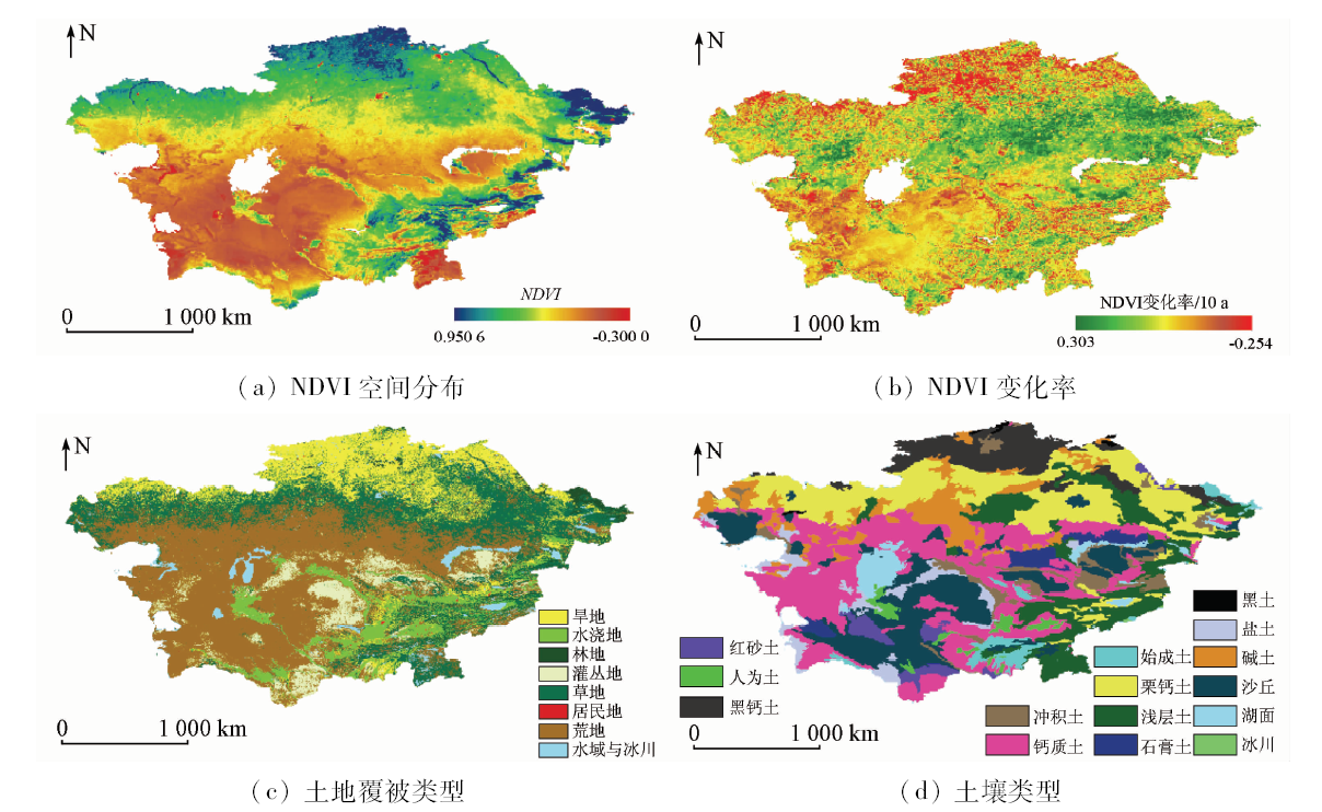
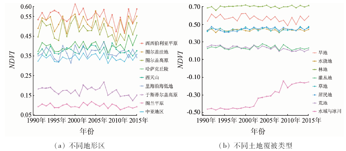
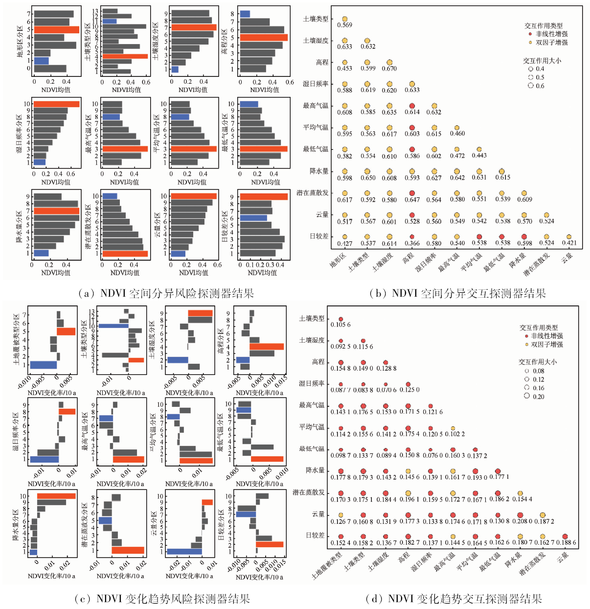
Vegetation is an important nexus connecting atmosphere, pedosphere, hydrosphere and biosphere. Therefore, the relationship between the temporal and spatial variation characteristics of vegetation and its driving factors is of great significance in the study of regional ecological environment changes. Based on multiple data sets such as GIMMS NDVI and CRU, the authors analyzed the temporal and spatial variation characteristics of NDVI in Central Asia from 1991 to 2015, using trend analysis and geo-detector model that included factor detection, risk detection and interaction analysis. The results show that the vegetation activities in Central Asia have remained stable and volatile on the whole in the past 25 years. In detail, NDVI in the middle and low altitude areas of the Kazakh hills has increased significantly, while the NDVI in the southwestern part of Aral Sea has been significantly reduced because of the close diffusion of salt dust in the Aral Sea basin. In addition, because of the contradiction between water resources development and utilization among Central Asian countries, the trend of NDVI in the midstream of the Syr Darya and the downstream has been reversed. The non-irrigated farmland in northern Kazakhstan has a large decline in NDVI, and the results are not significant (P≥0.1) due to the phenomenon of re-cultivation. According to the results of geo-detector model, the water factor dominates the vegetation growth pattern in Central Asia, and the temperature is negatively correlated with the NDVI change. The difference in spatial and temporal variation of NDVI between different terrains, elevations, soil types and land use types is also significant. In terms of the interaction factor, the bi-factor interaction has enhanced the interpretation of spatial distribution and temporal and spatial variation of NDVI. The synergistic effect of potential evapotranspiration and elevation on the spatial distribution of NDVI is over 64%.
王伟, 阿里木·赛买提, 吉力力·阿不都外力. 基于地理探测器模型的中亚NDVI时空变化特征及其驱动因子分析[J]. 国土资源遥感, 2019, 31(4): 32-40.
Wei WANG, Samat Alim, Abuduwaili Jilili. Geo-detector based spatio-temporal variation characteristics and driving factors analysis of NDVI in Central Asia. Remote Sensing for Land & Resources, 2019, 31(4): 32-40.
Chen F H, Wang J S, Jin L Y , et al. Rapid warming in mid-latitude Central Asia for the past 100 years[J]. Frontiers of Earth Science in China, 2009,3(1):42-50.
[2]
秦大河 . 气候变化科学概论[M]. 北京: 科学出版社, 2018: 35-38.
Qin D H. Introduction to Climate Change Science[M]. Beijing: Science Press, 2018: 35-38.
[3]
Klein I, Gessner U, Kuenzer C . Regional land cover mapping and change detection in Central Asia using MODIS time-series[J]. Applied Geography, 2012,35(1-2):219-234.
[4]
Micklin P .The future Aral Sea:Hope and despair[J].Environmental Earth Sciences, 2016, 75(9): 844, 1-15.
[5]
Bezborodov G A, Shadmanov D K, Mirhashimov R T , et al. Mulching and water quality effects on soil salinity and sodicity dynamics and cotton productivity in Central Asia[J]. Agriculture Ecosystems and Environment, 2010,138(1):95-102.
Cheng Y P, Zhang F W, Dong H , et al. Wetland dynamic monitoring in Central Asia based on MODIS image[J]. Hydrogeology and Engineering Geology, 2010,37(5):33-37.
Cheng C, Fu W X, Hu Z L , et al. Changes of major lakes in Central Asia over the past 30 years revealed by remote sensing technology[J]. Remote Sensing for Land and Resources, 2015,27(1):146-152.doi: 10.6046/gtzyyg.2015.01.23.
[8]
Schwartz M D . Green-wave phenology[J]. Nature, 1998,394(6696):839-840.
Yin G, Meng X Y, Wang H , et al. Spatial-temporal variation of vegetation and its correlation with climate change in Central Asia during the period of 1982—2012[J]. Acta Ecologica Sinica, 2017,37(9):3149-3163.
Deng X Y, Yao J Q, Liu Z H . Spatiotemporal dynamic change of vegetation coverage in arid regions in Central Asia based on GIMMS NDVI[J]. Arid Zone Research, 2017,34(1):10-19.
Suo Y X, Wang Z X, Liu C , et al. Relationship between NDVI and precipitation and temperature in Middle Asia during 1982—2002[J]. Resources Science, 2009,31(8):1422-1429.
Zhang Q, Yuan X L, Chen X , et al. Vegetation change and its response to climate change in Central Asia from 1982 to 2012[J]. Chinese Journal of Plant Ecology, 2016,40(1):13-23.
Suo Y X . Correlation of Vegetation Dynamics and Climate Variability in the Middle Asia[D]. Beijing:Graduate School of Chinese Academy of Science, 2009.
[14]
Shigaeva J, Kollmair M, Niederer P , et al. Livelihoods in transition:Changing land use strategies and ecological implications in a post-Soviet setting (Kyrgyzstan)[J]. Central Asian Survey, 2007,26(3):389-406.
Hu R J, Jiang F Q, Wang Y J , et al. Arid ecological and geographical conditions in five countries of Central Asia[J]. Arid Zone Research, 2014,31(1):1-12.
Liu X F, Zhu X F, Pan Y Z , et al. Spatiotemporal changes in vegetation coverage in China during 1982—2012[J]. Acta Ecologica Sinica, 2015,35(16):5331-5342.
Liu J F, Ma S, Li S , et al. Changes in vegetation NDVI from 1982 to 2016 and its responses to climate change in the black-soil area of Northeast China[J]. Acta Ecologica Sinica, 2018,38(21):7647-7657.
Mu S J, Li J L, Zhou W , et al. Spatial-temporal distribution of net primary productivity and its relationship with climate factors in Inner Mongolia from 2001 to 2010[J]. Acta Ecologica Sinica, 2013,33(12):3752-3764.
Zhao N, Ma C, Yang Y L . Water quality variation of Lake Hongjiannao and its driving force analysis from 1973 to 2013[J]. Journal of Lake Sciences, 2016,28(5):982-993.
[22]
Dara A, Baumann M, Kuemmerle T , et al. Mapping the timing of cropland abandonment and recultivation in northern Kazakhstan using annual Landsat time series[J]. Remote Sensing of Environment, 2018,213:49-60.
[23]
Shen H, Abuduwaili J, Samat A , et al.A review on the research of modern aeolian dust in Central Asia[J].Arabian Journal of Geosciences, 2016, 9(13): 625, 1-16.
[24]
Ge Y X, Abuduwaili J, Ma L, et al.Temporal variability and potential diffusion characteristics of dust aerosol originating from the Aral Sea Basin, Central Asia[J].Water Air and Soil Pollution , 2016, 227(2): 63, 1-12.
 2019, Vol. 31
  )
)