Dynamic evaluation and prediction of ecological environment vulnerability in the middle-upper reaches of the Yalong River
YAO Kun1(), ZHANG Cunjie2(), HE Lei3, LI Yuxia4, LI Xiaoju5
1. College of Resource and Environment, Xichang University, Xichang 615000, China 2. National Climate Center, Beijing 100081, China 3. School of Software Engineering, Chengdu University of Information Technology, Chengdu 610103, China 4. School of Automation Engineering, University of Electronic Science and Technology of China, Chengdu 610054, China 5. Engineering College, Universitiy Putra Malaysia, Kuala Lumpur 43400, Malaysia
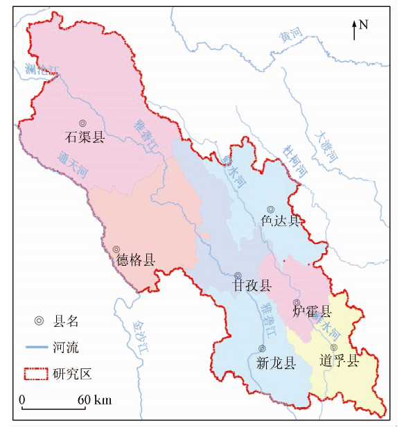
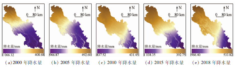
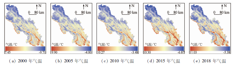
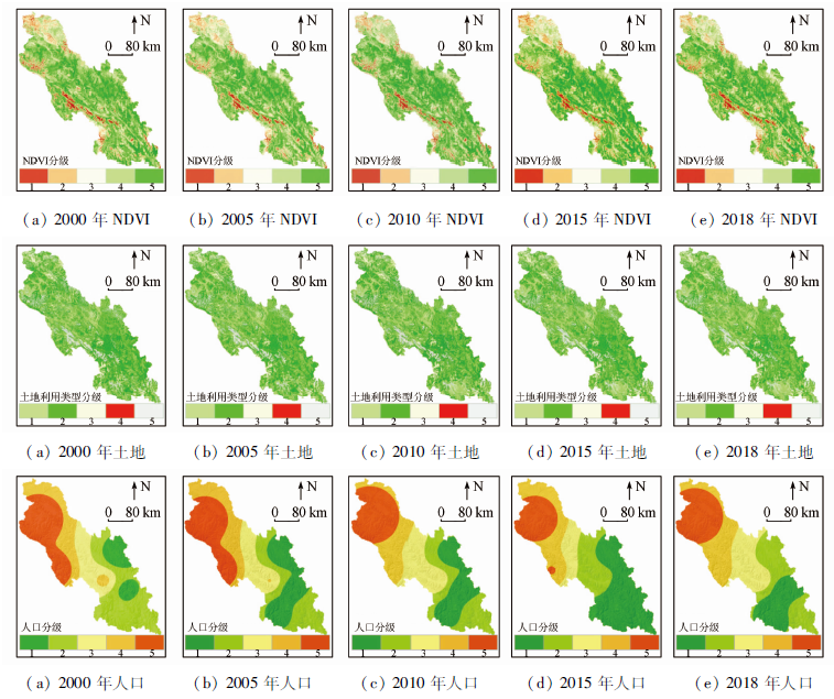
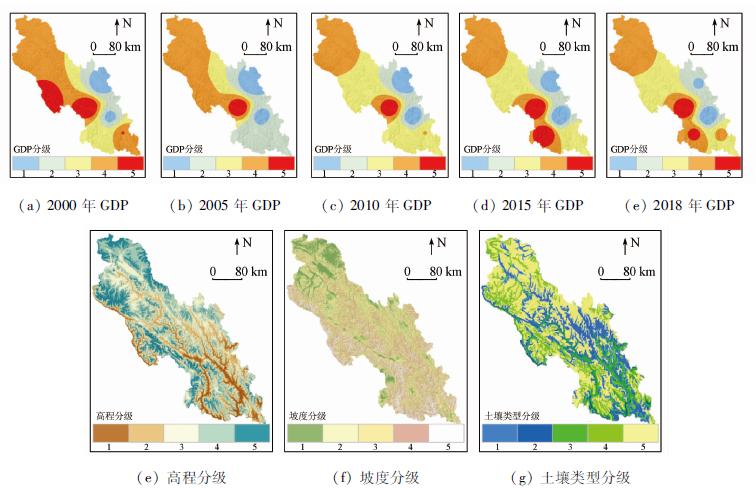
In order to timely grasp the changes and future development of the ecological environment vulnerability, the authors selected 9 indicators, such as elevation, slope and land use type. Combining RS and GIS technology with AHP-PCA entropy weight model, the authors evaluated the vulnerability of the region in 2000—2018 dynamically, and introduced CA-Markov model for the development of 2021 simulation prediction. The following results have been achieved: ①The overall vulnerability of the region shows gradual decrease in gradient from north to south. ②The degree of vulnerability shows a gradual decrease in the proportion of micro, light, potential, moderate and severe grids. ③CA-Markov is not only suitable for predicting ecological vulnerability in the region, but also with high accuracy, and the proportion of potential, micro, mild, moderate and severe grids in 2021 is 20.18%, 38.02%, 25.71%, 10.96% and 5.13% respectively. ④Throughout the study period, the region’s vulnerability composite index is 2.539 2, 2.501 6, 2.485 6 , 2.460 7 and 2.436 6, respectively, and the 2021 value is 2.428 5. The continuous decrease of this value indicates that the overall ecological environment of the region has been effectively improved and will be in a state of change with sustained and good development. The study effectively reveals the law of dynamic change of ecological environment vulnerability in middle-upper reaches of the Yalong River Basin. With a more scientific analysis of its main drivers and future development, it can be used as an important theoretical reference for the formulation of ecological protection measures in the region.
姚昆, 张存杰, 何磊, 李玉霞, 李小菊. 雅砻江中上游流域生态环境脆弱性动态评价及预测[J]. 国土资源遥感, 2020, 32(4): 199-208.
YAO Kun, ZHANG Cunjie, HE Lei, LI Yuxia, LI Xiaoju. Dynamic evaluation and prediction of ecological environment vulnerability in the middle-upper reaches of the Yalong River. Remote Sensing for Land & Resources, 2020, 32(4): 199-208.
Zhang X N, Wang K L, Zhang W, et al. The quantitative assessment of eco-environment vulnerability in Karst regions of northwest Guangxi[J]. Acta Ecologica Sinica, 2009,29(2):749-757.
Wei J, Guo Y M, Sun L, et al. Evaluation of ecological environment vulnerability for Sanjiangyuan area[J]. Chinese Journal of Ecology, 2015,34(7):1968-1975.
Xie R D, Zhao C W. Spatio-temporal differentiation of ecological environment vulnerability in Karst trough region based on grid scale[J]. Journal of Yangtze River Scientific Research Institute, 2018,35(4):48-53.
Lin J H, Hu G J, Qi X H, et al. Ecological environmental vulnerability and its driving forces in urban agglomeration in the Fujian Delta region[J]. Acta Ecologica Sinica, 2018,38(12):4155-4166.
Shao Q F, Peng P H, Huang J, et al. Monitoring eco-environmental vulnerability in Anning River Basin in the upper reaches of the Yangtze River using remote sensing techniques[J]. Remote Sensing for Land and Resources, 2016,28(2):175-181.doi: 10.6046/gtzyyg.2016.02.27.
Tian C, Yang X J, Ju Y H, et al. Dynamic evaluation of ecological vulnerability in western Jilin Province[J]. Research of Soil and Water Conservation, 2018,25(4):298-303.
Guo M D, Han J C, Shi Y, et al. Assessment of eco-environmental vulnerability based on DPRISM conceptual framework:A case study of upper Minjiang River[J]. Compute Techniques for Geophysical and Geochemical Exploration, 2019,41(1):128-134.
Zhang M, Luo H L, Chen L. Vulnerability assessment of resource-based city:A case study of Panzhihua[J]. Resources and Environment in the Yangtze Basin, 2018,27(5):1170-1178.
Xian W, Li T, Shao H Y. Ecological frangibility evaluation of Anning River Basin in the Upper Yangtze River based on support vector machine[J]. Environmental Science and Technology, 2014,37(11):180-184.
Chen J Y, Wang S Y. Ecological environment vulnerability assessment in upper reaches of Minjiang River[J]. Resources and Environment in the Yangtze Basin, 2017,26(3):471-479.
Yang B, Zhan J F, Li M J. Evaluation of environmental vulnerability in the upper reaches of the Minjiang River[J]. Remote Sensing for Land and Resources, 2014,26(4):138-144.doi: 10.6046/gtzyyg.2014.04.22.
Wang Z J, Su Y. Analysis of eco-environmental vulnerability characteristics of Hanzhong City,near the water source midway along the route of the south-to-north water transfer project,China[J]. Acta Ecologica Sinica, 2018,38(2):432-442.
Yao J, Ding J, Ai N S. Assessment ecological vulnerability in the upper reaches of the Minjiang River[J]. Resources and Environment in the Yangtze Basin, 2004(4):380-383.
Zhong X J, Sun B P, Zhao Y, et al. Ecological vulnerability evaluation based on principal component analysis in Yunnan Province[J]. Ecology and Environmental Sciences, 2011,20(1):109-113.
Liu Z J, Yu X X, Li L, et al. Vulnerability assessment of eco-environment in Yimeng Mountainous area of Shandong Province based on SRP conceptual model[J]. Chinese Journal of Applied Ecology, 2011,22(8):2084-2090.
pmid: 22097371
[17]
Shao H, Liu M, Shao Q, et al. Research on eco-environmental vulnerability evaluation of the Anning River Basin in the upper reaches of the Yangtze River[J]. Environmental Earth Sciences, 2014,72(5):1555-1568.
[18]
Shao H, Sun X, Tao S, et al. Environmental vulnerability assessment in middle-upper reaches of Dadu River watershed using projection pursuit model and GIS[J]. Carpathian Journal of Earth and Environmental Sciences, 2015,10(4):143-146.
[19]
Shao H, Sun X, Wang H, et al. A method to the impact assessment of the returning grazing land to grassland project on regional eco-environmental vulnerability[J]. Environmental Impact Assessment Review, 2016,56:155-167.
Wang X, Niu Y X, Li Y. Entropy weight-based evaluation of ecological environment along highways[J]. Journal of Southwest University (Natural Science Edition), 2010,32(9):168-172.
Ou D H, Xia J G, Ou X F. Regional ecological security assessment and change trend prediction in per-urban areas based on GIS and RBF:A case study in Longquanyi District of Chengdu City[J]. Geo-graphy and Geo-Information Science, 2017,33(1):49-58.
Zhang X J, Zhou Q G, Wang Z L, et al. Simulation and prediction of land use change in Three Gorges Reservoir Area based on MCE-CA-Markov[J]. Transactions of the Chinese Society of Agricultural Engineering, 2017,33(19):268-277.
Li F, Liu X Y, Yu X T, et al. Eco-environmental quality evaluation of coal city based on AHP-PCA model[J]. Mining Safety and Environmental Protection, 2017,44(5):103-106,110.
Xia X S, Zhu X F, Li Y C, et al. Evaluation for vulnerability of agroecological environment in Three Gorges Reservoir area(Chongqing section)based on AHP-PCA entropy combination weight mode[J]. Journal of Southern Agriculture, 2016,47(4):548-556.
Chen Z L, Peng S H, Qian J, et al. Distribution characteristics of geological hazards in southwestern shallow hill based on AHP-Logistic entropy combined weight model:A case study of Neijiang[J]. Journal of Yangtze River Scientific Research Institute, 2020,37(2):55-61.
Hou C C, Zhao X Y, Zhang L, et al. Ecological security evaluation of grassland based on combined weight on principle of relative entropy:A case of Yellow River water source areas of Gannan[J]. Journal of Arid Land Resources and Environment, 2012,26(8):44-51.
Wu K Y, Jin J L. Attribute recognition method of regional ecological security evaluation based on combined weight on principle of relative entropy[J]. Scientia Geographica Sinica, 2008,28(6):754-758.
Tan J B, Li A N, Lei G B. Contrast on Anusplin and Cokriging meteorological spatial interpolation in southeastern margin of Qinghai-Xizang Plateau[J]. Plateau Meteorology, 2016,35(4):875-886.
doi: 10.7522/j.issn.1000-0534.2015.00037
[32]
Li A N, Wang A S, Liang S L, et al. Eco-environmental vulnerability evaluation in mountainous region using remote sensing and GIS:A case study in the upper reaches of Minjiang River,China[J]. Ecological Modelling, 2006,192(1-2):175-187.
doi: 10.1016/j.ecolmodel.2005.07.005
Deng L J, Hou D B, Wang C Q, et al. Soil erodibility characteristics of natural soil and dryland in Sichuan Province[J]. Soil and Water Conservation in China, 2003(7):27-29,48.
Ma J, Li C X, Wei H, et al. Dynamic evaluation of ecological vulnerability in the Three Gorges Reservoir Region in Chongqing Municipality,China[J]. Acta Ecologica Sinica, 2015,35(21):7117-7129.
Ren J T, Mo S J, Chen Q L, et al. Analysis and prediction of land use and land cover changes in Caohai Wetland areas[J]. Journal of Xinyang Normal University (Natural Science Edition), 2017,30(3):385-392.
Ai L Y, Wang S J, Zhang Z. Spatial-temporal evolution and prediction of vegetation cover in central part of Xilingol grassland during 1997—2017[J]. Bulletin of Soil and Water Conservation, 2019,39(5):249-256.
[37]
Wang L X, Yu D Y, Liu Z, et al. Study on NDVI changes in Weihe Watershed based on CA-Markov model[J]. Geological Journal, 2018,53:435-441.
Gong X M, Feng W L, Zheng J, et al. Assessment of soil erosion sensitivity in the upper reaches of Minjiang River[J]. Journal of Arid Land Resources and Environment, 2017,31(9):68-74.
 2020, Vol. 32
  ), 张存杰2(