Remote sensing image scene classification based on Inception-V3
CAI Zhiling1(), WENG Qian1(), YE Shaozhen1, JIAN Cairen2
1. College of Mathematics and Computer Science, Fuzhou University, Fuzhou 350116, China 2. School of Information Science and Technology, Xiamen University Tan Kahkee College, Zhangzhou 363105, China
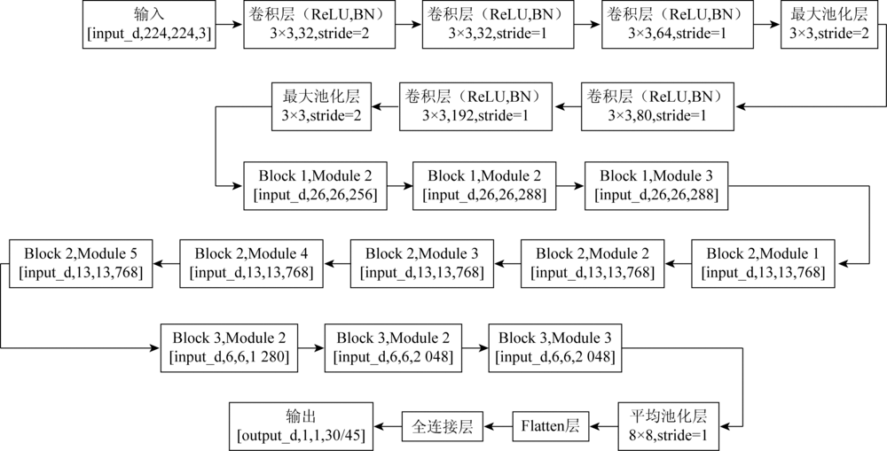
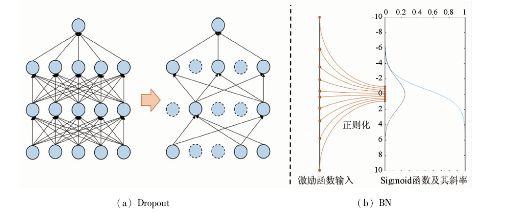
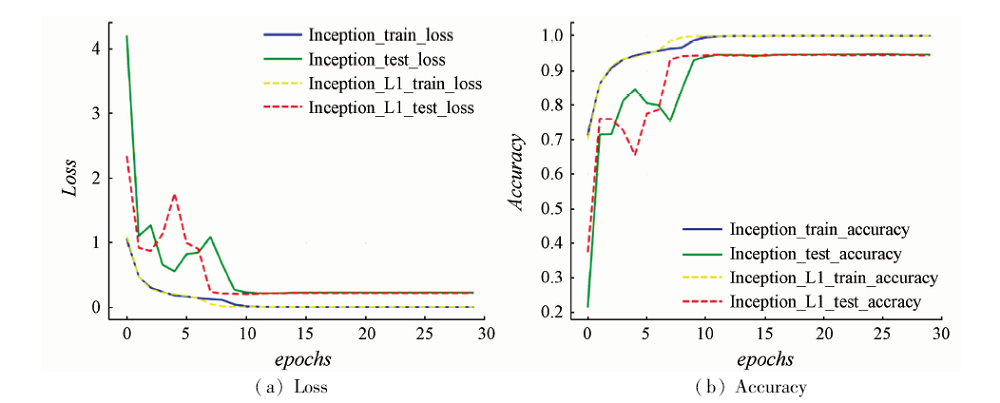
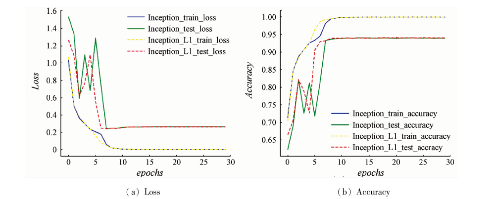
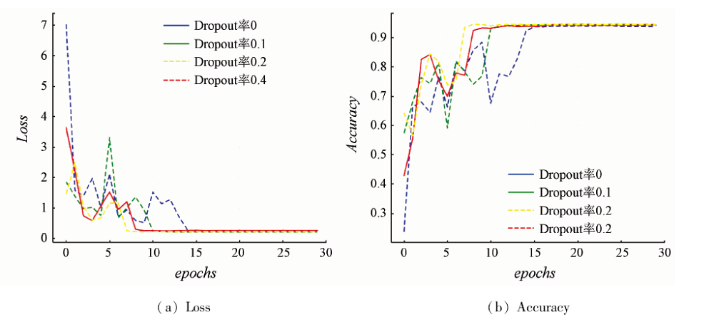
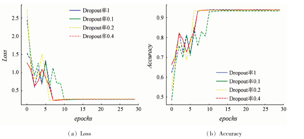
With the deepening and cross-fusion of modern remote sensing image research, the classification of high spatial resolution remote sensing image (referred to as “high-resolution image”) has become a research hotspot in the field of remote sensing. As the phenomenon of “homology spectrum” and “homology spectrum” of high-resolution image is more serious, the deep learning method that has emerged in recent years has proposed a new solution for high-resolution image classification. However, the lack of training samples of remote sensing images can easily lead to over-fitting of deep learning networks. In this paper, an improved Inception-V3 remote sensing image scene classification model is proposed by using deep learning method and transfer learning strategy. The model first adds Dropout layer before the full connection layer of the original Inception-V3 model in order to avoid over-fitting. In the training process, the transfer learning strategy is adopted to make full use of the existing model and knowledge and improve the training efficiency. The experimental results based on AID and NWPU-RESISC45 datasets show that the improved Inception-V3 has faster convergence speed and smoother training effect than the original Inception-V3 training. Compared with accuracy of other traditional methods and deep learning networks, the classification accuracy of the proposed model has been greatly improved and verified. The effectiveness of the model is verified.
蔡之灵, 翁谦, 叶少珍, 简彩仁. 基于Inception-V3模型的高分遥感影像场景分类[J]. 国土资源遥感, 2020, 32(3): 80-89.
CAI Zhiling, WENG Qian, YE Shaozhen, JIAN Cairen. Remote sensing image scene classification based on Inception-V3. Remote Sensing for Land & Resources, 2020, 32(3): 80-89.
Cui L, Zhang P, Che J. Overview of remote sensing image classification algorithm based on depth neural network[J]. Computer Science, 2018,45(s1):50-53.
Zhang K, Hei B Q, Li S Y, et al. Classification of complex scene of remote sensing image based on CNN model[J]. Remote Sensing of Land and Resources, 2018,30(4):49-55.doi: 10.6046/gtzyyg.2018.04.08.
[3]
Chen C, Zhang B, Su H, et al. Land-use scene classification using multi-scale completed local binary patterns[J]. Signal,Image & Video Processing, 2016,10(4):745-752.
[4]
Xia G S, Hu J W, Hu F, et al. AID:A benchmark data set for performance evaluation of aerial scene classification[J]. IEEE Transactions on Geoscience and Remote Sensing, 2017,55(7):3965-3981.
doi: 10.1109/TGRS.2017.2685945
[5]
Swain M J, Ballard D H. Color indexing[J]. International Journal of Computer Vision, 1991,7(1):11-32.
doi: 10.1007/BF00130487
[6]
Oliva A, Torralba A. Modeling the shape of the scene:A holistic representation of the spatial envelope[J]. International Journal of Computer Vision, 2001,42(3):145-175.
doi: 10.1023/A:1011139631724
[7]
Ojala T, Pietikainen M, Maenpaa T. Multiresolution gray-scale and rotation invariant texture classification with local binary patterns [C]//European Conference on Computer Vision.Springer, 2000: 404-420.
[8]
Lowe D G. Distinctive image features from scale-invariant keypoints[J]. International Journal of Computer Vision, 2004,60(2):91-110.
doi: 10.1023/B:VISI.0000029664.99615.94
[9]
Yang Y, Newsam S. Bag-of-visual-words and spatial extensions for land-use classification [C]//Proceedings of the 18th ACM SIGSPATIAL International Conference on Advances in Geographic Information Systems.San Jose:ACM, 2010: 270-279.
[10]
Lazebnik S, Schmid C, Ponce J. Beyond bags of features:Spatial pyramid matching for recognizing natural scene categories [C]//2006 IEEE Computer Society Conference on Computer Vision and Pattern Recognition (CVPR'06).New York:IEEE, 2006: 2169-2178.
[11]
Wang J, Yang J, Yu K, et al. Locality-constrained linear coding for image classification [C]//2010 IEEE Computer Society Conference on Computer Vision and Pattern Recognition.San Francisco:IEEE, 2010: 3360-3367.
[12]
Bosch A, Zisserman A, Muñoz X. Scene classification via pLSA [C]//European Conference on Computer Vision.Springer, 2006: 517-530.
[13]
Perronnin F, Sánchez J, Mensink T. Improving the fisher kernel for large-scale image classification [C]//European Conference on Computer Vision.Springer, 2010: 143-156.
[14]
Jegou H, Perronnin F, Douze M, et al. Aggregating local image descriptors into compact codes[J]. IEEE Transactions on Pattern Analysis and Machine Intelligence, 2012,34(9):1704-1716.
doi: 10.1109/TPAMI.2011.235
[15]
Zou Q, Ni L, Zhang T, et al. Deep learning based feature selection for remote sensing scene classification[J]. IEEE Geoscience and Remote Sensing Letters, 2015,12(11):2321-2325.
doi: 10.1109/LGRS.2015.2475299
Ge Y, Jiang S L, Ye F M, et al. Remote sensing image retrieval based on CNN features[J]. Remote Sensing for Land and Resources, 2019,31(1):49-57.doi: 10.6046/gtzyyg.2019.01.07.
[17]
Weng Q, Mao Z, Lin J, et al. Land-use classification via extreme learning classifier based on deep convolutional features[J]. IEEE Geoscience and Remote Sensing Letters, 2017,14(5):704-708.
doi: 10.1109/LGRS.2017.2672643
Qian X L, Li J, Cheng G, et al. Evaluation of the effect of feature extraction strategy on scene classification performance of high resolution remote sensing image[J]. Journal of Remote Sensing, 2018,22(5):758-776.
Dang Y, Zhang J X, Deng K Z, et al. Classification and evaluation of surface coverage of remote sensing images based on deep learning AlexNet[J]. Journal of Geoinformatics, 2017,19(11):1530-1537.
[20]
Krizhevsky A, Sutskever I, Hinton G E. ImageNet classification with deep convolutional neural networks [C]//Advances in Neural Information Processing Systems, 2012: 1097-1105.
[21]
Simonyan K, Zisserman A. Very deep convolutional networks for large-scale image recognition[EB/OL].(2014-12-23)[2019-11-06]. https://arxiv.org/abs/1409.1556.
[22]
Szegedy C, Liu W, Jia Y, et al. Going deeper with convolutions [C]//Proceedings of the IEEE Conference on Computer Vision and Pattern Recognition.IEEE, 2015: 1-9.
[23]
He K, Zhang X, Ren S, et al. Deep residual learning for image recognition [C]//Proceedings of the IEEE Conference on Computer Vision and Pattern Recognition. IEEE, 2016: 770-778.
Wang X, Li K, Xu M J, et al. Improved classification algorithm of remote sensing image based on deep learning[J]. Computer Applications, 2019,39(2):382-387.
Liu D W, Han L, Han X Y. Research on high-resolution remote sensing image classification based on deep learning[J]. Acta Optics Sinica, 2016,36(4):306-314.
[26]
Szegedy C, Liu W, Jia Y Q, et al. Going deeper with convolutions [C]//Conference on Computer Vision and Pattern Recognition. 2015: 1-9.
[27]
Li X, Chen S, Hu X, et al.Understanding the disharmony between dropout and batch normalization by variance shift[EB/OL].(2018 -01-16)[2019-11-06]. https://arxiv.org/abs/1801.05134.
Lin Z W, Tu W H, Huang J H, et al. Tree species recognition based on FC-DenseNet in low altitude aerial optical images[J]. Remote Sensing for Land and Resources, 2019,31(3):225-233.doi: 10.6046/gtzyyg.2019.03.28.
 2020, Vol. 32
  ), 翁谦1(