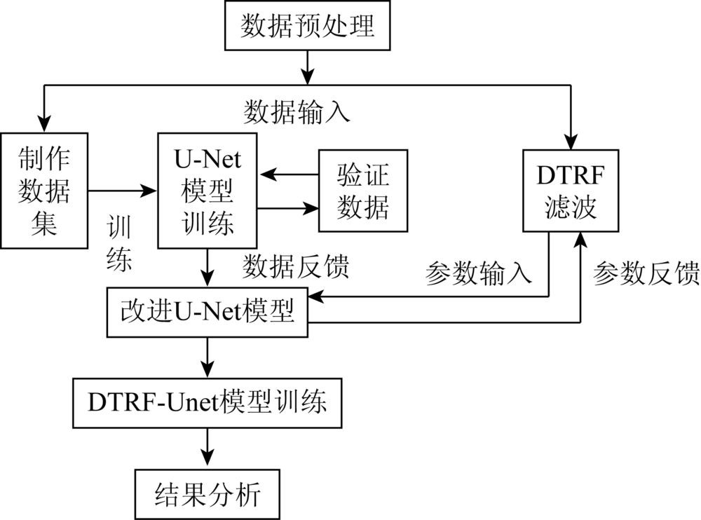
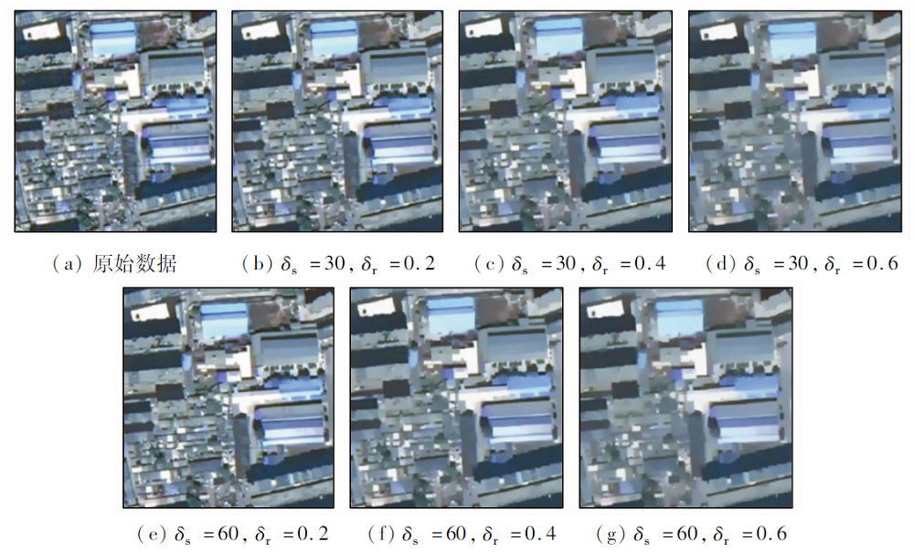
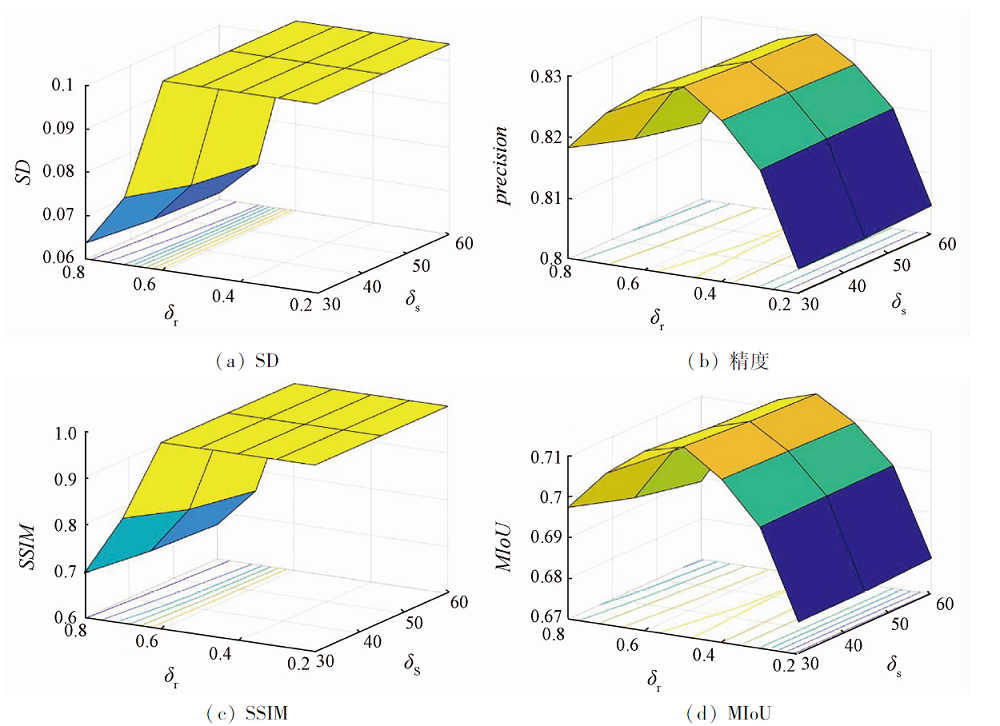
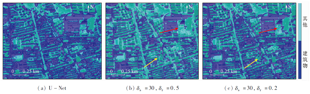
ing at tackling the problem that some edge features of buildings are easily blurred or lost in the extraction of buildings with high resolution image by U-Net, this paper proposes an optimized building extraction method, which firstly enhances the edge of buildings with high resolution image and simultaneously improves the partial convolution process of U-Net. Specific process is as follows: Firstly, the domain change recursive filtering method is used to enhance the edge of the building, and the enhanced image is input into U-Net neural network results for training. To make full use of the rich details characteristics of the buildings on the GF-2 images, the authors tried to extract pairs from training images and label patch on the basis of the original U-Net structure and in the process of coding decoding, so as to increase the training data. These patches further strengthened the positive and negative deep learning of high-dimensional feature for buildings, thus successfully realizing building image segmentation. In this paper, the experimental results of the extraction of GF-2 image buildings in Panjin City of Liaoning Province adjacent to Bohai Bay on September 29, 2017 show that the overall classification accuracy of the buildings detected by U-Net is 75.99% for the shaded and unsatisfied area sample data, and the maximum overall classification accuracy of this method can reach 83.12%, which is 7.13 percentage higher than that of the original U-Net network. It is proved that the U-NET model combined with domain change recursive filtering is effective.
武宇, 张俊, 李屹旭, 黄康钰. 基于改进U-Net的建筑物集群识别研究[J]. 国土资源遥感, 2021, 33(2): 48-54.
WU Yu, ZHANG Jun, LI Yixu, HUANG Kangyu. Research on building cluster identification based on improved U-Net. Remote Sensing for Land & Resources, 2021, 33(2): 48-54.
Peng H T, Ke C Q. Study on object-oriented remote sensing image classification based on multi levels segmentation[J]. Remote Sensing Technology and Application, 2010, 25(1)149-154.
[3]
Camps-Valls G, Gomez-Chova L, Munoz-Mari J, et al. Composite kernels for hyperspectral image classification[J]. IEEE Geoscience and Remote Sensing Letters, 2006, 3(1):93-97.
doi: 10.1109/LGRS.2005.857031
[4]
沈毅. 高分辨率遥感图像处理若干关键技术研究[D]. 南京:南京航空航天大学, 2012.
Shen Y. Research on some key technologies of high-resolution remote sensing image processing[D]. Nanjing:Nanjing University of Aeronautics and Astronautics, 2012.
Sui H G, Feng W Q, Li W Z, et al. Review of change detection methods for multi-temporal remote sensing imagery[J]. Geomatics and Information Science of Wuhan University, 2018, 43(12):1885-1898.
[6]
Baltsavias E P. Object extraction and revision by image analysis using existing geodata and knowledge:Current status and steps towards operational systems[J]. ISPRS Journal of Photogrammetry & Remote Sensing, 2004, 58(3/4):129-151.
[7]
Alarcon-Ramirez A, Rwebangira M R, Chouikha M F, et al. A new methodology based on level sets for target detection in hyperspectral images[J]. IEEE Transactions on Geoence & Remote Sensing, 2016, 54(9):5385-5396.
[8]
Wei G, Wen Y, Haijian Z, et al. Geospatial object detection in high resolution satellite images based on multi-scale convolutional neural network[J]. Remote Sensing, 2018, 10(1):131.
doi: 10.3390/rs10010131
Fang X, Wang G H, Yang H C, et al. High resolution remote sensing image classification combined with mean shift segmentation and full convolutional neural network[J]. Advances in Laser and Optoelectronics, 2018, 55(2):022802.
[10]
Krizhevsky A, Sutskever I, Hinton G E. ImageNet classification with deep convolutional neural networks[C]// International Conference on Neural Information Processing Systems, 2012, 60(2):1097-1105.
[11]
Mou L, Ghamisi P, Zhu X X. Deep recurrent neural networks for hyperspectral image classification[J]. IEEE Transaction Geoscience and Remote Sensing, 2017, 55(7):3639-3655.
doi: 10.1109/TGRS.2016.2636241
Wang N, Cheng J H, Zhang H Y, et al. Application of U-net model to water extraction with high resolution remote sensing data[J]. Remote Sensing for Land and Resources, 2020, 32(1):35-42.doi: 10.6046/gtzyyg.2020.01.06.
doi: 10.6046/gtzyyg.2020.01.06
Li Y S, Zhen H W, Luo G P, et al. Extraction and counting of Populus Euphratica crown using UAV images integrated with U-Net method[J]. Remote Sensing Technology and Application, 2019, 34(5):939-949.
[15]
Long J, Shelhamer E, Darrell T. Fully convolutional networks for semantic segmentation[C]// IEEE Conference on Computer Vision and Pattern Recognition.IEEE, 2015, 79(11):3431-3440.
Su J M, Yang L X, Jing W P. U-Net based semantic segmentation method for high resolution remote sensing image[J]. Computer Engineering and Applications, 2019, 55(7):207-213.
Zhang H, Wang K F, Wang F Y. Advances and perspectives on applications of deep learning in visual object detection[J]. Journal of Automation, 2017, 43(8):1289-1305.
Wu G M, Chen Q, Shibasaki R, et al. High precision building detection from aerial imagery using a U-Net like convolutional architecture[J]. Acta Geodaetica et Cartographica Sinica, 2018, 47(6):864-872.
[19]
向轩琳. 基于域变换递归滤波的高光谱图像分类方法研究[D]. 长沙:湖南大学, 2018.
Xiang X L. Research on hyperspectral image classification method based on domain transform recursive filter[D]. Changsha:Hunan University, 2018.
[20]
Gastal E S L, Oliveira M M. Domain transform for edge-aware image and video processing[C]// ACM Transactions on Graphics. 2011, 30(4):1-12.
[21]
Kang X D, Duan P H, Li S T. Hyperspectral image visualization with edge-preserving filtering and principal component analysis[J]. Information Fusion, 2020, 57:130-143.
doi: 10.1016/j.inffus.2019.12.003
[22]
Ronneberger O, Fischer P, Brox T. U-Net:Convolutional networks for biomedical image segmentation[C]// Medical Image Computing and Computer-Assisted Intervention.Springer, 2015:234-241.
[23]
Badrinarayanan V, Kendall A, Cipolla R. SegNet:A deep convolutional encoder-decoder architecture for image segmentation[J]. IEEE Transactions on Pattern Analysis & Machine Intelligence, 2017, 39(12):2481-2495.
Zhang H R, Zhao J H, Zhang X G. High resolution remote sensing image building extraction method using U-net network[J]. Remote Sensing Information, 2020, 35(3):143-150.
[25]
Li R, Liu W, Yang L, et al. DeepUNet:A deep fully convolutional network for pixel-level sea-land segmentation[J]. IEEE Journal of Selected Topics in Applied Earth Observations & Remote Sensing, 2018, 11(11):3954-3962.
 2021, Vol. 33
  ), 张俊1, 李屹旭2(