Denoising algorithm based on the fusion of lifting wavelet thresholding and multidirectional edge detection of remote sensing image of mining area
WANG Xiaobing1,2,3()
1. Sinosteel Maanshan General Institute of Mining Research Co., Ltd., Maanshan 243000, China 2. State Key Laboratory of Safety and Health for Metal Mines, Maanshan 243000, China 3. Huawei National Engineering Research Center of High Efficient Cyclic and Utilization of Metallic Mineral Resources Co., Ltd., Maanshan 243000, China
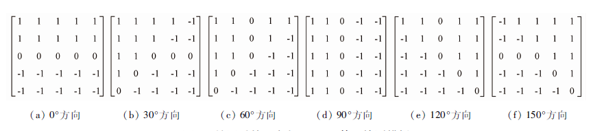
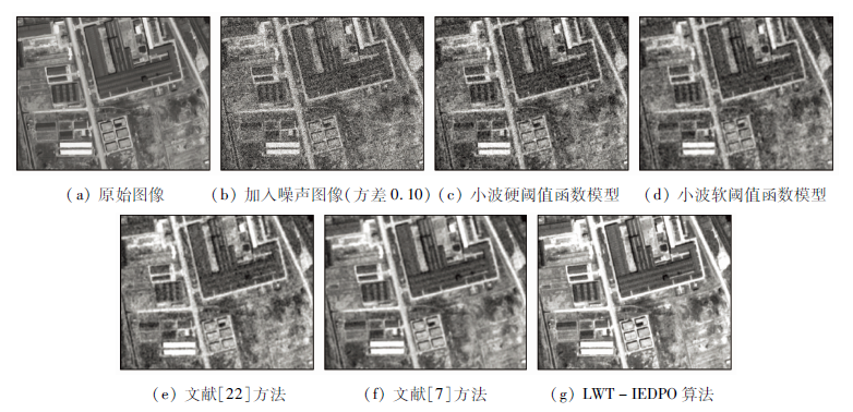
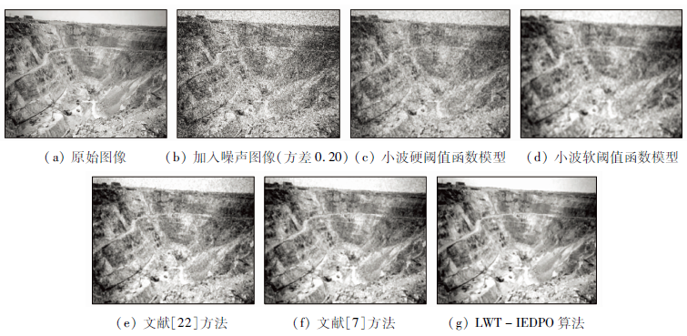
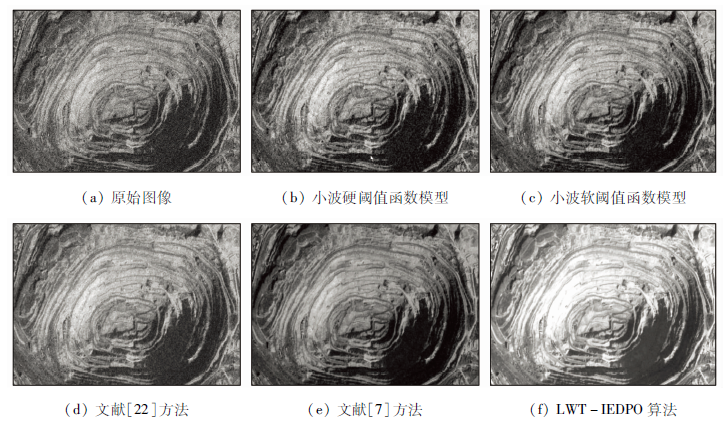
Remote sensing image plays an important role in ecological restoration, geological disaster monitoring and prevention of mining area; nevertheless, due to the complex environment of mining area, the obtained remote sensing images of the mining area contains different kinds of intensity noise, which affects the subsequent image interpretation and analysis to a great extent. In this paper, the study ideas of image edge detection and noise suppression are effectively fused together, and the improved denoising method (LWT-IEDPO) of remote sensing image in mining area based on the fusion of lifting wavelet thresholding (LWT) and improved edge dectction of Prewitt operator (IEDPO) is proposed. According to the basic principal of the new method proposed in this paper, firstly, lifting wavelet transform is done for the original remote sensing image; under the condition that the low-frequency wavelet sub-band is left untreated, a two-parameters thresholding function model is designed for adaptive noise suppression of high-frequency sub-bands, and the remote sensing image after initial denoising is obtained by the operation of inverse lifting wavelet transform. Secondly, for the purpose of effectively enhancing the details of the filtered remote sensing image, the detection template of the classical Prewitt operator is extended to 6 directions of 0°, 30°, 60°, 90°, 120° and 150°, and the corresponding detection results fusion rules are proposed. The improved Prewitt operator is put forward to extract the image edge information of the filtered image, and the edge and non-edge image are obtained. Then, the visual effect non-edge image is further improved by adopting the improved Pal-King fuzzy algorithm. Finally, the goal of high definition restoration of the original remote sensing image is realized by the superimposition of the enhanced non-edge image and edge image. Based on MATLAB language, the proposed remote sensing image processing method is compared with the classical hard thresholding model, soft thresholding model and two existing improved wavelet thresholding algorithms; in addition, the two indices of peak signal to noise ratio (PSNR) and edge protection index (EPI) are used to conduct quantitative analysis and comparison of the performance of the above algorithms. The study results show that the goal of effectively filtering of noise remote sensing image can be realized effectively, and the overall performance of the proposed algorithm is better than that of the other four algorithms.
王小兵. 融合提升小波阈值与多方向边缘检测的矿区遥感图像去噪[J]. 国土资源遥感, 2020, 32(4): 46-52.
WANG Xiaobing. Denoising algorithm based on the fusion of lifting wavelet thresholding and multidirectional edge detection of remote sensing image of mining area. Remote Sensing for Land & Resources, 2020, 32(4): 46-52.
Zhang Y J. Remote sensing image processing method of mining area based on bilateral filtering algorithm and wavelet thresholding method[J]. Metal Mine, 2017(9):170-173.
Ren C, Li X G, Deng K Y, et al. Mixed noise denoising method for remote sensing images combining BM3D and multi-level nonlinear weighted average median filtering[J]. Bulletin of Surveying and Mapping, 2020(1):89-93.
Gao F, Zhu L, Feng Z J, et al. Non-local mean filtering algorithm for SAR image based on coefficient of variation[J]. Information and Communications, 2019(10):42-44.
Chen Q J, Shi X H, Chai Y Z. Image denoising algorithm based on wavelet transform and convolutional neural network[J]. Journal of Applied Optics, 2020,41(2):288-295.
Zhang Q. Remote sensing image de-noising algorithm based on double discrete wavelet transform[J]. Remote Sensing for Land and Resources, 2015,27(4):14-20.doi: 10.6046/gtzyyg.2015.04.03.
Liu S W, Gao L Y, Wang B. Research on image denoising algorithm of joint bilateral filter and wavelet threshold shrinkage[J]. Remote Sensing for Land and Resources, 2018,30(2):114-124.doi: 10.6046/gtzyyg.2018.02.16.
Xu D, Sun L, Luo J S. Denoising of hyperspectral remote sensing imagery using NAPCA and complex wavelet transform[J]. Infrated and Laser Engineering, 2015,44(1):327-334.
Huang T, Xue F C, Qian H L, et al. Remote sensing image denoising algorithm based on NSCT and adaptive fuzzy threshold[J]. Computer Technology and Development, 2016,26(1):65-69.
Ding H Y, Guo R R, Luo H B. Denoising of remote sensing images using adaptive threshold in NSCT domain by concerning texture information[J]. Remote Sensing Technology and Application, 2017,32(3):435-442.
Wang X B, Sun J Y, Tang H Y. A new filter algorithm based on mathematical morphology and wavelet domain enhancement[J]. Microelectronics and Computer, 2012,29(7):64-67.
Wang X B, Sun J Y, Tang H Y. Adaptive filtering algorithm for mixed noise image based on wavelet transform[J]. Microelectronics and Computer, 2012,29(6):91-95.
Wang X B, Yao X Q, Qiu Y G, et al. A new filtering algorithm for video monitoring image of coal mine[J]. Industry and Mine Automation, 2014,40(11):76-80.
Wang Y X, Cao C L, Li P, et al. Part of residual phase simulation and purify based on the lifting wavelet transform method[J]. Science of Surveying and Mapping, 2019,44(10):165-171.
[20]
Zhang L B, Chen J, Qiu B C. Region of interest extraction in remote sensing images by saliency analysis with the normal directional lifting wavelet transform[J]. Neurocomputing, 2016,179:186-201.
doi: 10.1016/j.neucom.2015.11.093
Dong X, Lin Z X, Guo T L. Improved self-adaptive threshold wavelet denoising analysis based on LoG operator[J]. Chinese Journal of Liquid Crystals and Displays, 2014,29(2):275-280.
doi: 10.3788/YJYXS20142902.0275
Ji F, Li C, Chang X, et al. Adaptive image denoising based on the improved threshold function[J]. Chinese Journal of Sensors and Actuators, 2014,27(3):351-354.
[23]
Zhou R G, Yu H, Cheng Y, et al. Quantum image edge extraction based on improved Prewitt operator[J]. Quantum Information Processing, 2019,18(9):1-24.
[24]
Tian X S. A novel image edge detection algorithm based on Prewitt operator and wavelet transform[J]. International Journal of Advancements in Computing Technology, 2012,19(4):73-82.
 2020, Vol. 32
  )
)