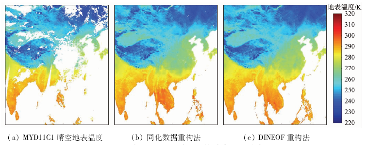
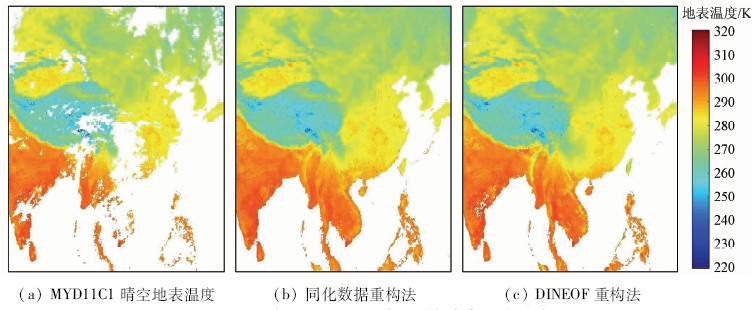
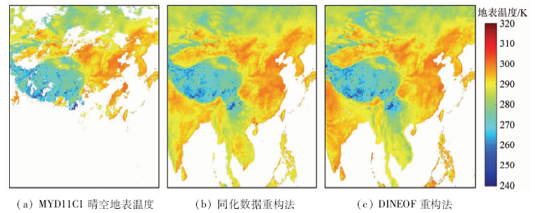
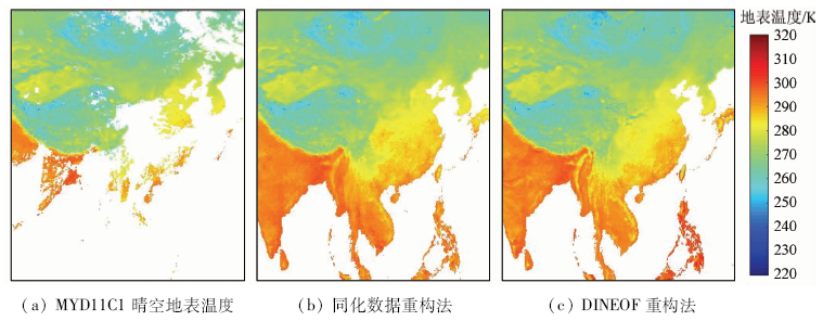
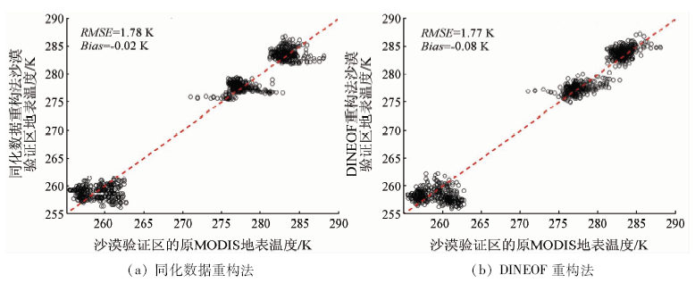
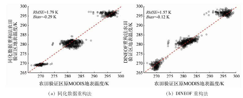
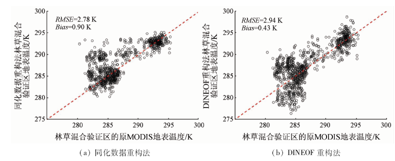
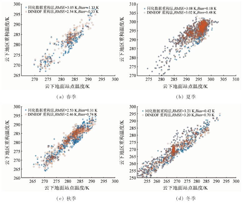
Land surface temperature is a key parameter in the study of the balance of water and heart between land surface and atmosphere. Obtainment of land surface temperature under all-weather conditions is very important. Although thermal infrared remote sensing technology can retrieve land surface temperature with high spatial resolution and full space coverage in cloud-free sky, the missing data in cloudy sky limit the all-weather applications of land surface temperature in some areas. This study develops two methods for reconstructing missing land surface temperature in cloudy skies. One of the methods is a space-time matched interpolation method helped with dataset of lands surface temperature assimilation. The other method is by data interpolating empirical orthogonal function (DINEOF), which is already popular in reconstruction of sea surface parameters but is rarely used in reconstruction of land surface parameters. The two methods are evaluated by both remotely sensed data and ground measured data in 2017, and the results demonstrate that both of them are adaptable in all seasons and all over China. The accuracies of two methods are very close and located between 2.5 and 3.5 K in cloudy conditions in four seasons in China. This study aims to give some useful references in the study of obtainment of land surface temperature under all-weather conditions.
周芳成, 唐世浩, 韩秀珍, 宋小宁, 曹广真. 云下遥感地表温度重构方法研究[J]. 国土资源遥感, 2021, 33(1): 78-85.
ZHOU Fangcheng, TANG Shihao, HAN Xiuzhen, SONG Xiaoning, CAO Guangzhen. Research on reconstructing missing remotely sensed land surface temperature data in cloudy sky. Remote Sensing for Land & Resources, 2021, 33(1): 78-85.
Chen L, Huang W T, Wu J, et al. Ore-forming temperature variation and prospecting target of the Wuxu ore field in Guangxi[J]. Geochimica, 2015,44(6):546-555.
[2]
Voogt J A, Oke T R. Thermal remote sensing of urban climates[J]. Remote Sensing of Environment, 2003,86(3):370-384.
Li Z L, Duan S B, Tang B H, et al. Review of methods for land surface temperature derived from thermal infrared remotely sensed data[J]. Journal of Remote Sensing, 2016,20(5):899-920.
Zhang L H, Chen Y N, Zhao R F, et al. Impact of temperature and soil water content on soil respiration in temperate deserts,China[J]. Chinese Journal of Plant Ecology, 2009,33(5):936-949.
[6]
Arnfield A J. Two decades of urban climate research:A review of turbulence,exchanges of energy and water,and the urban heat island[J]. International Journal of Climatology, 2003,23(1):1-26.
[7]
Kalma J D, Mcvicar T R, Mccabe M F. Estimating land surface evaporation:A review of methods using remotely sensed surface temperature data[J]. Surveys in Geophysics, 2008,29(4-5):421-469.
[8]
Kogan F N. Operational space technology for global vegetation assessment[J]. Bulletin of the American Meteorological Society, 2001,82(9):1949-1964.
[9]
Valor E, Caselles V. Mapping land surface emissivity from NDVI:Application to European,African,and South American areas[J]. Remote Sensing of Environment, 1996,57(3):167-184.
[10]
Li Z L, Tang B H, Wu H, et al. Satellite-derived land surface temperature:Current status and perspectives[J]. Remote Sensing of Environment, 2013,131(131):14-37.
[11]
Wan Z, Zhang Y, Zhang Q, et al. Quality assessment and validation of the modis global land surface temperature[J]. International Journal of Remote Sensing, 2004,25(1), 261-274.
[12]
Duan S B, Li Z L. Spatial downscaling of MODIS land surface temperatures using geographically weighted regression:Case study in northern China[J]. IEEE Transactions on Geoscience and Remote Sensing, 2016,54(11):6458-6469.
Guo J R, Song J, Bao X W, et al. The method study of remote sensing data reconstruction in multi-scale variations of chlorophyll in east China sea[J]. Remote Sensing Technology and Application, 2016,31(5):939-949.
Zhao B, Mao K B, Cai Y L, et al. Study of the temporal and spatial evolution law of land surface temperature in China[J]. Remote Sensing for Land and Resources, 2020,32(2):233-240.doi: 10.6046/gtzyyg.2020.02.30.
Wu D, Chen J, Shi M, et al. Reconstruction of land surface temperature time-series datasets of FY-2F based on Savitzky-Golay filter[J]. Remote Sensing for Land and Resources, 2019,31(2):59-65.doi: 10.6046/gtzyyg.2019.02.09.
[16]
Beckers J M, and Rixen M. EOF calculations and data filling from incomplete oceanographic datasets[J]. Journal of Atmospheric and Oceanic Technology, 2003,20(12):1839-1856.
[17]
Gandin L S. Objective analysis of meteorological fields[J]. Israel Program for Scientific Translation,Jerusalem. 1963.
[18]
Alvera-Azcárate A, Barth A, Rixen M, et al. Reconstruction of incomplete oceanographic data sets using empirical orthogonal functions:Application to the Adriatic Sea surface temperature[J]. Ocean Modelling, 2005,9(4):325-346.
[19]
Alvera-Azcárate A, Barth A, Beckers J M, et al. Multivariate reconstruction of missing data in sea surface temperature,chlorophyll,and wind satellite fields[J]. Journal of Geophysical Research:Oceans, 2007,112(c3).
Dou W J, Zhou B, Jiang J G, et al. Data reconstruction algorithm of remote sensing SST products and accuracy analysis based on the same latitude DINEOF[J]. Journal of Zhejiang University(Science Edition), 2015,42(2):205-212.
Guo H X, Cai R S, Tan H J, et al. A preliminary study on missing remote sensing data of Chlorophyll-a in Taiwan Strait and reconstruction by DINEOF method[J]. Journal of Applied Oceanography, 2016,35(4):550-558.
Wang Y Q, Liu D Y. Reconstruction of satellite ocean color data based on DINEOF method:A case study in Bohai and Yellow Sea[J]. Remote Sensing Information, 2014,29(5):51-57.
[23]
Zhou W, Peng B, Shi J, et al. Estimating high resolution daily air temperature based on remote sensing products and climate reanalysis datasets over glacierized basins:A case study in the Langtang valley,Nepal[J]. Remote Sensing, 2017,9(9):959.
 2021, Vol. 33
  ), 唐世浩1(