Landslide identification using remote sensing images and DEM based on convolutional neural network: A case study of loess landslide
YANG Zhaoying1,2(), HAN Lingyi1(), ZHENG Xiangxiang1, LI Wenji1, FENG Lei1, WANG Yi1, YANG Yongpeng1,2
1. China Aero Geophysical Survey and Remote Sensing Center for Natural Resources, Beijing 100083, China 2. Key Laboratory of Airborne Geophysics and Remote Sensing Geology, Ministry of Natural Resources, Beijing 100083, China
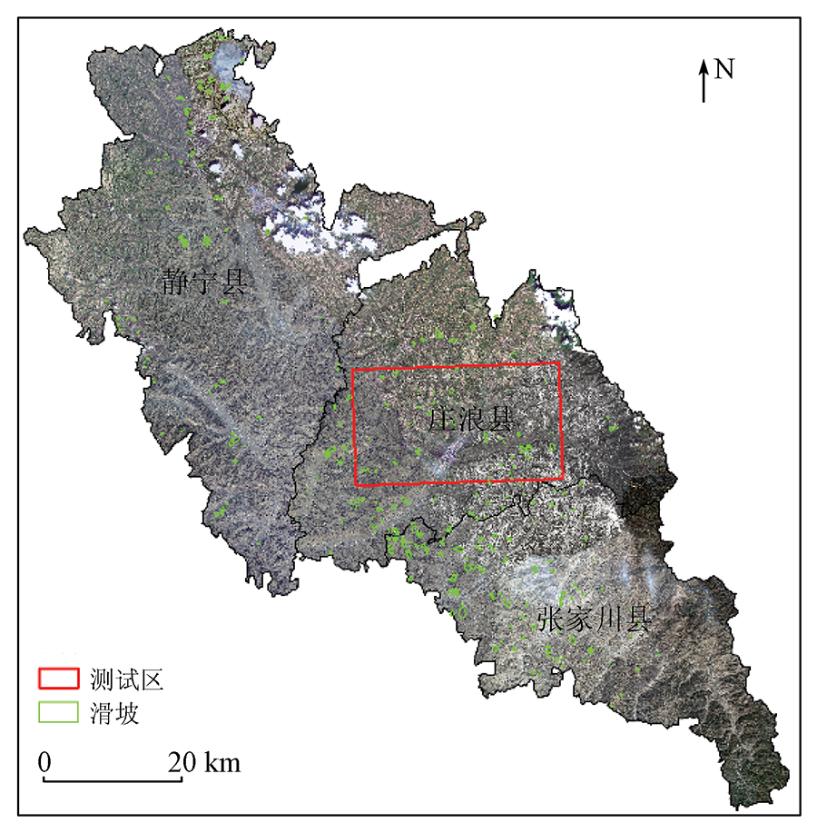
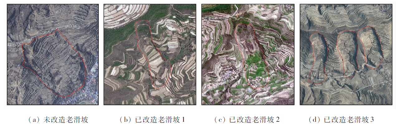
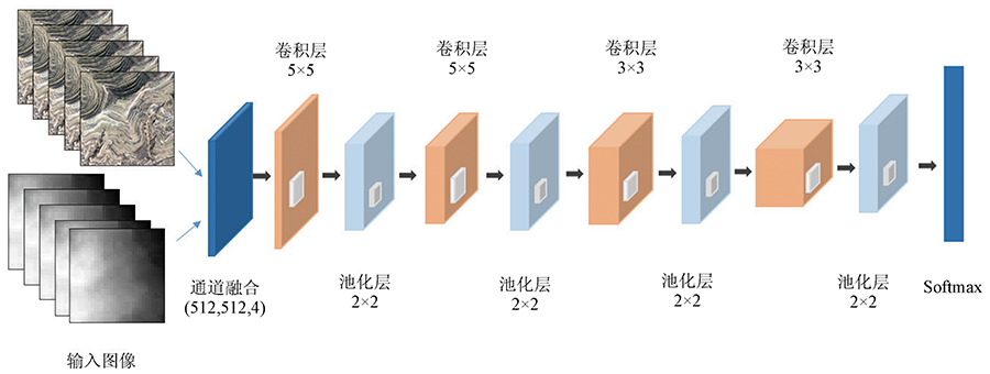
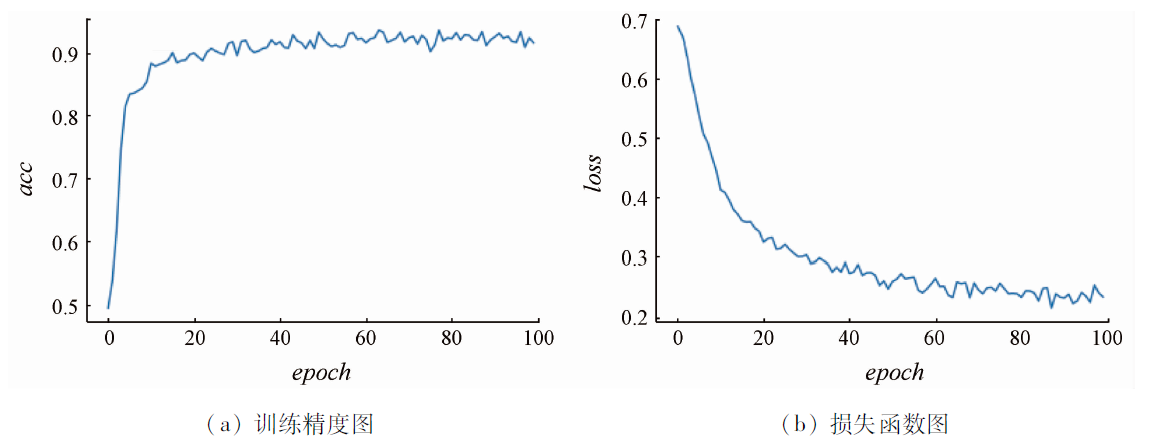
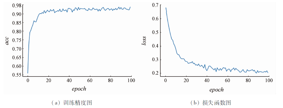
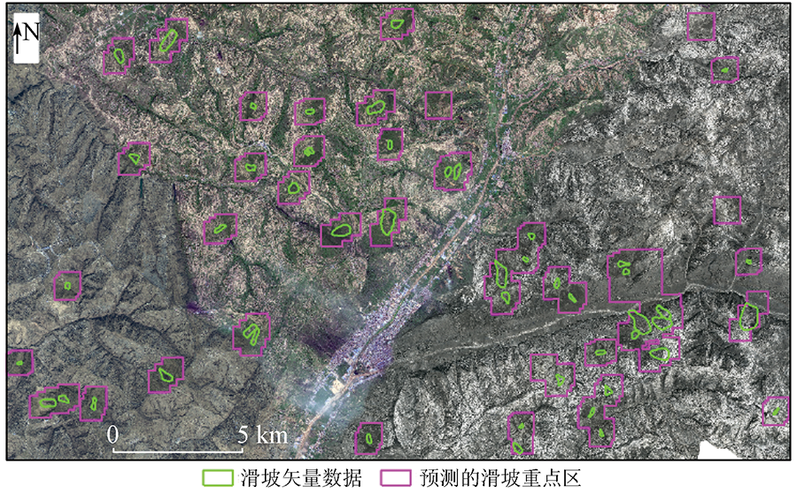
China is one of the countries with frequent landslide disasters. In recent years. In recent years, more than 70% of the catastrophic geological hazards have occurred not within the scope of known hidden danger points of geological hazards in China. Therefore, there is an urgent need for investigating large-scale landslide disasters using automatic and efficient technologies and methods for landslide identification. To quickly identify the location of landslides from massive remote sensing images, it is necessary to determine the key areas of landslides to support subsequent interpretation and research. This study investigated loess landslide identification based on GF-1 images and digital elevation model (DEM) data. First, a database of remote sensing images and DEM landslide samples was constructed. Second, the landslide samples were classified using the channel fusion convolutional neural network model. Finally, the classification results were restored to the remote sensing images according to the location information. Experimental results showed that the model yielded landslide identification accuracy of 95.7% and a recall rate of 100.0%. The model used in this study has a small number of network layers, a high convergence speed, and higher efficiency and identification accuracy. As a result, it allows for the quick identification of key landslide areas from remote sensing images in the case of a limited number of samples, thus supporting the investigation of large-scale landslide disasters.
杨昭颖, 韩灵怡, 郑向向, 李文吉, 冯磊, 王轶, 杨永鹏. 基于卷积神经网络的遥感影像及DEM滑坡识别——以黄土滑坡为例[J]. 自然资源遥感, 2022, 34(2): 224-230.
YANG Zhaoying, HAN Lingyi, ZHENG Xiangxiang, LI Wenji, FENG Lei, WANG Yi, YANG Yongpeng. Landslide identification using remote sensing images and DEM based on convolutional neural network: A case study of loess landslide. Remote Sensing for Natural Resources, 2022, 34(2): 224-230.
Xu Q, Dong X J, Li W L. Integrated space-air-ground early detection,monitoring and warning system for potential catastrophic geohazards[J]. Geomatics and Information Science of Wuhan University, 2019, 44(7):957-966.
Zhang S J. Research on landslide body extraction method from high-resolution remote sensing image based on change detection and object-oriented[D]. Chengdu: Southwest Jiaotong University, 2017.
Zhou Z H, Lin W F, Xu G C, et al. Research of fast landslide recognition based on object-oriented technology[J]. Journal of Abhui Agricultural Sciences, 2012, 40(5):3017-3018,3071.
Ding H, Zhang M S, Zhu W H, et al. High resolution remote sensing for the identification if loess landslides:Example from Yan’an City[J]. Northwestern Geology, 2019, 52(3):231-239.
[6]
Ye C M, Li Y, Cui P, et al. Landslide detection of hyperspectral remote sensing data based on deep learning with constrains[J]. IEEE Journal of Selected Topics in Applied Earth Observations and Remote Sensing, 2019, 12(12):5047-5060.
doi: 10.1109/JSTARS.2019.2951725
[7]
Ghorbanzadeh O, Blaschke T, Gholamnia K, et al. Evaluation of different machine learning methods and deep-learning convolutional neural networks for landslide detection[J]. Remote Sensing, 2019, 11(2):1-21.
doi: 10.3390/rs11010001
[8]
Wang H J, Zhang L M, Yin K S, et al. Landslide identification using machine learning[J]. Geoscience Frontiers, 2020, 12(1):351-364.
doi: 10.1016/j.gsf.2020.02.012
Ju Y Z, Xu Q, Jin S C, et al. Automatic object detection of loess landslide based on deep learning[J]. Geomatics and Information Science of Wuhan University, 2020, 45(11):1747-1755.
[10]
Ji S P, Yu D W, Shen C Y, et al. Landslide detection from an open satellite imagery and digital elevation model dataset using attention boosted convolutional neural networks[J]. Landslides, 2020:1-16.
[11]
Yu B, Chen F, Xu C. Landslide detection based on contour-based deep learning framework in case of national scale of Nepal in 2015[J]. Computers & Geosciences, 2020, 135:104388.
doi: 10.1016/j.cageo.2019.104388
[12]
Ullo S L, Mohan A, Sebastianelli A, et al. A new Mask R-CNN-based method for improved landslide detection[J]. IEEE Journal of Selected Topics in Applied Earth Observations and Remote Sensing, 2021, 14:3799-810.
doi: 10.1109/JSTARS.2021.3064981
[13]
Cheng L, Li J, Duan P, et al. A small attentional YOLO model for landslide detection from satellite remote sensing images[J]. Landslides, 2021, 18(8):2751-65.
doi: 10.1007/s10346-021-01694-6
[14]
Catani F. Landslide detection by deep learning of non-nadiral and crowdsourced optical images[J]. Landslides, 2021, 18(3):1025-44.
doi: 10.1007/s10346-020-01513-4
[15]
Hacıefendioğlu K, Demir G, Başağa H B. Landslide detection using visualization techniques for deep convolutional neural network models[J]. Natural Hazards, 2021, 109(1):329-50.
doi: 10.1007/s11069-021-04838-y
 2022, Vol. 34
  ), 韩灵怡1(