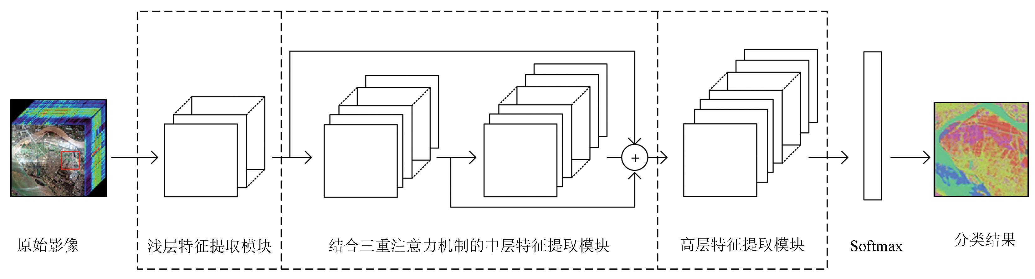
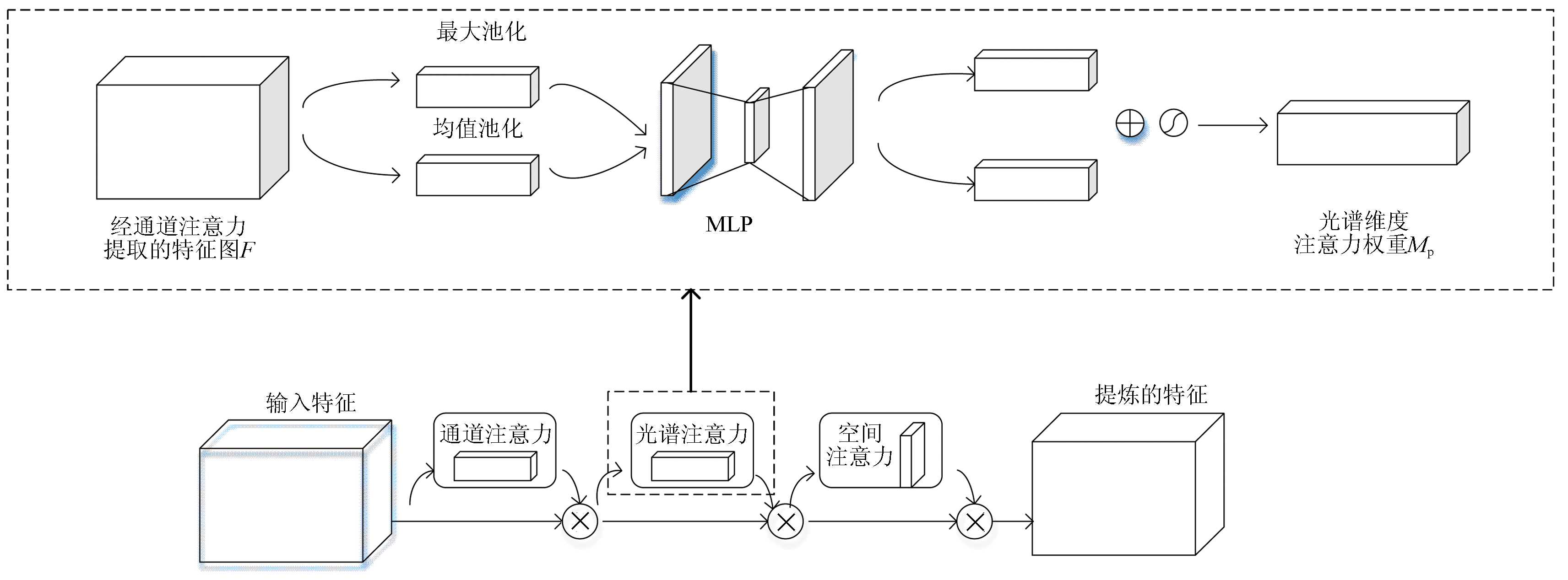
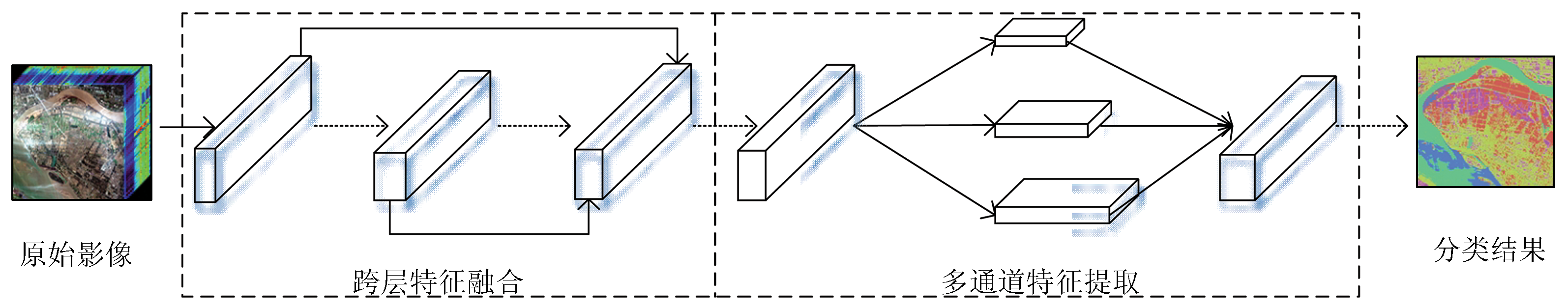
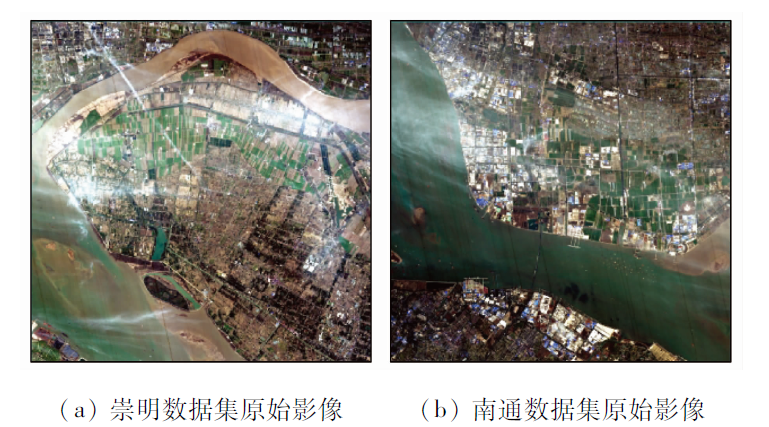
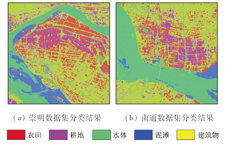
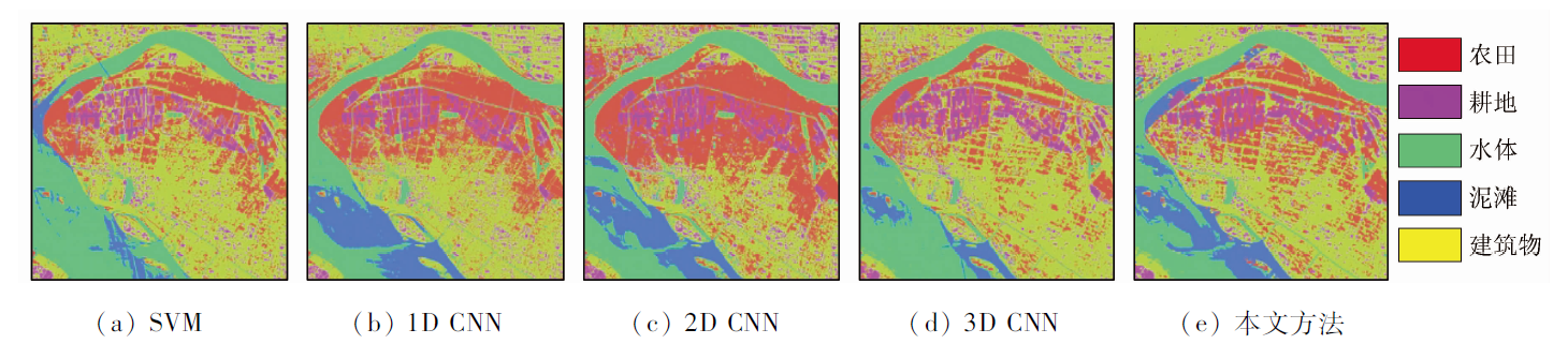
Hyperspectral images are characterized by large data volumes, multiple bands, and strong interband correlation. Conventional classification methods using hyperspectral images usually consider only spectral or spatial information, while suffering insufficient feature extraction and ignoring the texture structures and important spectral information of images. Aiming at these problems, this study proposed a new classification method using hyperspectral images. First, multi-scale spatial-spectral data were processed based on the three-dimensional convolutional neural network (3D CNN), and a spectral attention mechanism was proposed by improving the dual attention mechanism. Then, the classification accuracy of surface features was further improved by adopting cross-layer feature fusion and multi-channel feature extraction strategies. In this study, 6 043 samples of two scenes of images captured by the GF-5 satellite were selected as experimental data. The proposed method was compared with five other methods, namely the support vector machine (SVM), the one-dimensional convolutional neural network (1D CNN), the two-dimensional convolutional neural network (2D CNN), the 3D CNN, and the residual network (ResNet). The results show that the method proposed in this study yielded significantly improved overall accuracy (OA) and Kappa coefficients with averages of 95.25% and 0.943, respectively. When applied to the dataset of Nantong, Jiangsu, this method yielded OA of up to 95.84%, which was 21.54, 21.71, 7.28, 3.94, and 2.56 percentage points higher than that of the five other methods, respectively.
Ye Z, Bai L, He M Y. Overview of spatial spectrum feature extraction of hyperspectral images[J]. Chinese Journal of image and graphics, 2021, 26(8):1737-1763.
Wang Z H, Zhang X Y, Liu Z X, et al. Improved lattice Boltzmann parallel model for remote sensing ground object segmentation[J]. Remote Sensing Information, 2021, 36(4):1-6.
Tu B, Zhang X F, Zhang G Y, et al. Hyperspectral remote sensing image classification method based on recursive filtering and KNN[J]. Remote Sensing of Land and Resources, 2019, 31(1):22-32.doi: 10.6046/gtzyyg.2019.01.04.
doi: 10.6046/gtzyyg.2019.01.04
[4]
Peng J, Zhou Y, Chen C. Region-kernel-based support vector machines for hyperspectral image classification[J]. IEEE Transactions on Geoscience and Remote Sensing, 2015, 53(9):4810-4824.
doi: 10.1109/TGRS.2015.2410991
[5]
Peng J, Li L, Tang Y Y. Maximum likelihood estimation-based joint sparse representation for the classification of hyperspectral remote sensing images[J]. IEEE Transactions on Neural Networks and Learning Systems, 2018, 30:1790-1802.
doi: 10.1109/TNNLS.5962385
[6]
Chen G Y. Multiscale filter-based hyperspectral image classification with PCA and SVM[J]. Journal of Electrical Engineering, 2021, 72(1):40-45.
doi: 10.2478/jee-2021-0006
Liang L, Yang M H, Li Y F. Hyperspectral remote sensing image classification based on ICA and SVM algorithm[J]. Spectroscopy and Spectral Analysis, 2010, 30(10):2724-2728.
pmid: 21137408
Zhang B. Hyperspectral image processing and information extraction frontier[J]. Journal of Remote Sensing, 2016, 20(5):1062-1090.
[9]
Tong L, Zhang J, Ye Z. Classification of hyperspectral image based on deep belief networks[C]// 2014 IEEE International Conference on Image Processing (ICIP), 2014:5132-5136.
[10]
Zabalza J, Ren J C, Zheng J B, et al. Novel segmented stacked autoencoder for effective dimensionality reduction and feature extraction in hyperspectral imaging[J]. Neurocomputing, 2016, 185:1-10.
doi: 10.1016/j.neucom.2015.11.044
[11]
Hu W, Huang Y Y, Wei L, et al. Deep convolutional neural networks for hyperspectral image classification[J]. Journal of Sensors, 2015:1-12.
[12]
Zhao W, Du S. Learning multiscale and deep representations for classifying remotely sensed imagery[J]. ISPRS Journal of Photogrammetry and Remote Sensing, 2016, 113:155-165.
doi: 10.1016/j.isprsjprs.2016.01.004
[13]
Yue J, Zhao W, Mao S, et al. Spectral-spatial classification of hyperspectral images using deep convolutional neural networks[J]. Remote Sensing Letters, 2015, 6(4-6):468-477.
doi: 10.1080/2150704X.2015.1047045
[14]
Ghamisi P, Chen Y, Xiao X Z. A self-improving convolution neural network for the classification of hyperspectral data[J]. IEEE Geoence and Remote Sensing Letters, 2017, 13(10):1537-1541.
[15]
Makantasis K, Karantzalos K, Doulamis A, et al. Deep supervised learning for hyperspectral data classifification through convolutional neural networks[J]. 2015 IEEE International Geoscience and Remote Sensing Symposium (IGARSS), 2015:4959-4962.
[16]
Li Y, Zhang H K, Shen Q. Spectral-spatial classification of hyperspectral imagery with 3D convolutional neural network[J]. Remote Sensing, 2017, 9(1):67.
doi: 10.3390/rs9010067
[17]
Woo S, Park J, Lee J, et al. CBAM:Convolutional block attention module[J]. Springer, 2018, 11211:3-19.
[18]
Sun H, Zheng X T, Lu X Q, et al. Spectral-spatial attention network for hyperspectral image classification[J]. IEEE Transactions on Geoscience and Remote Sensing, 2020, 58(5):3232-3245.
doi: 10.1109/TGRS.36
[19]
Hang R L, Li Z, Liu Q S, et al. Hyperspectral image classification with attention-aided CNNs[J]. IEEE Transactions on Geoscience and Remote Sensing, 2021, 59(3):2281-2293.
doi: 10.1109/TGRS.36
[20]
Ji S W, Xu W, Yang M, et al. 3D convolutional neural networks for human action recognition[J]. IEEE Transactions on Pattern Analysis and Machine Intelligence, 2013, 35(1):221-231.
pmid: 22392705
Han Y L, Cui P X, Yang S H, et al. Classification of hyperspectral images based on feature fusion of residual network[J]. Remote Sensing for Land and Resources, 2021, 33(2) :11-19.doi:10.6046/gtzyyg.2020209.
doi: 10.6046/gtzyyg.2020209
 2023, Vol. 35
  ), 刘海霞(