Method to calibrate the coordinates of transmission towers based on satellite images
MA Yutang1(), PAN Hao1, ZHOU Fangrong1, HUANG Ran1, ZHAO Jianeng1, LUO Jiqiang2, LIU Jing2,3, SUN Haoxuan4(), JIA Weijie5, ZHANG Tao6
1. Joint Laboratory of Power Remote Sensing Technology, Electric Power Research Institute, Yunnan Power Grid Company Ltd., Kunming 650217, China 2. China Academy of Space Technology Institute of Spacecraft System Engineering, Beijing 100094, China 3. School of Computer Science & Engineering, South China University of Technology, Guangzhou 510006, China 4. School of Remote Sensing and Information Engineering, Wuhan University, Wuhan 430079, China 5. China Aero Geophysical Survey and Remote Sensing Center for Natural Resource, Beijing 100083, China 6. Equipment Procurement Service Center of China’s Central Military Commission (CMC) Equipment Development Department (EDD), Beijing 100009, China
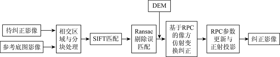
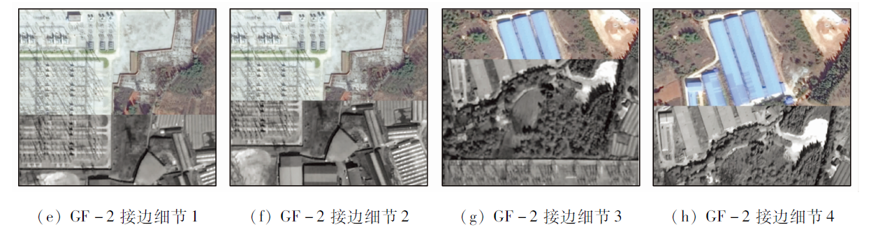
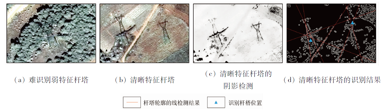
In order to realize the refined line inspection management of transmission lines, improve its operation and maintenance efficiency, realize satellite intelligent inspection, and accurately find the defects and hidden dangers of towers and transmission lines, the paper took the coordinates of transmission line towers in Kunming City, Yunnan Province as an example and proposed a method to calibrate the coordinates of transmission towers using satellite images. The method first uses the reference base-map data as the basis to match the control points and uses the digital elevation model (DEM) to perform geometric correction on the original remote sensing image. Then combined with such technologies as shadow detection and edge detection and visual interpretation, the calibrated tower coordinates are obtained. The experiment verified the geometric correction accuracy of the SuperView-1 (SV1) and Gaofen-2(GF2) satellite images in the Kunming area, and the errors in the plane after correction were 0.931 and 1.387 m, respectively. In addition, the experiment verified the calibration accuracy of the old tower coordinates on the two lines. The results show that the plane accuracy of the tower has increased from 13.811 m and 8.256 m to 5.970 m and 5.104 m, respectively, which meets the basic power grid requirements. This method can realize the calibration of the tower coordinates, reduce the workload of manual inspection, and improve the efficiency of line inspection. With the explosive growth of remote sensing image data, multi-source images from the space and ground will continue to be combined, and the technology for the positioning of transmission towers based on satellite remote sensing images will have a broader development prospect.
马御棠, 潘浩, 周仿荣, 黄然, 赵加能, 罗继强, 刘靖, 孙浩轩, 贾伟洁, 张涛. 基于卫星影像的输电杆塔坐标校准方法[J]. 自然资源遥感, 2022, 34(2): 63-71.
MA Yutang, PAN Hao, ZHOU Fangrong, HUANG Ran, ZHAO Jianeng, LUO Jiqiang, LIU Jing, SUN Haoxuan, JIA Weijie, ZHANG Tao. Method to calibrate the coordinates of transmission towers based on satellite images. Remote Sensing for Natural Resources, 2022, 34(2): 63-71.
Peng X Y, Qian J J, Mai X M, et al. Automatic power line inspection technology of large unmanned helicopter and its application[J]. Southern Power System Technology, 2016, 10(2):24-31.
Chen J H, Zhang Q, Feng W X, et al. Lightning location system and lightning detection network of China power grid[J]. High Voltage Engineering, 2008, 34(3):425-431.
Li W X, Li X, Feng J R, et al. Discuss on method to solve problem of pole or tower coordinates of power transmission line based on earth coordinate system[J]. Guangxi Electric Power, 2007(4):75-78.
Gao C F. Research on coordinate solution model of GPS post difference and correlated problems[J]. Acta Geodaetica et Cartographica Sinica, 2006, 35(2):148.
Du S Y, Yang Q, Huang Y, et al. Research and application of check on power transmission tower coordinate[J]. Guangdong Electric Power, 2014, 27(12):102-107.
Weng Y L, Fan X W, Hu W S, et al. Application of multisensor image and GIS in electric transmission line path design[J]. Journal of Southeast University (Natural Science Edition), 2013(s2):269-274.
Lu Y J, Teng L, Xing Y, et al. Application status of Beidou satellite navigation system in power industry[J]. Electric Power Information and Communication Technology, 2019, 17(8):70-74.
Mu X C, Zhou X K, Wang C X, et al. Research on power tower slip monitoring system based on Beidou and GPS dual system[J]. Electric Power Information and Communication Technology, 2019, 17(6):44-50.
Song J, Zhao F, Yan T F, et al. The application of high-precision GPS deformation monitoring system on monitor of power tower[J]. Automation & Instrumentation, 2014(8):63-65.
[12]
Liang X, Hyyppa J, Kukko A, et al. The use of a mobile laser scanning system for mapping large forest plots[J]. IEEE Geoscience & Remote Sensing Letters, 2014, 11(9):1504-1508.
[13]
刘洋. 机载点云电力走廊要素提取及风险计算[D]. 武汉: 武汉大学, 2018.
Liu Y. Feature extraction and inspection of transmission corridor based on ALS data[D]. Wuhan: Wuhan University, 2018.
[14]
张勇. 架空输电线路障碍物巡检的无人机低空摄影测量方法研究[D]. 武汉: 武汉大学, 2017.
Zhang Y. Inspection of overhead power line corridor obstacles by UAV photogrammetry[D]. Wuhan: Wuhan University, 2017.
Zhang F, Huang X F, Qu X Z, et al. Power line measurement method based on vertical baseline photogrammetry[J]. Bulletin of Surveying and Mapping, 2013(11):33-36.
[16]
屈航. 基于双目系统的电力线与地物间距离的测量[D]. 重庆: 重庆交通大学, 2013.
Qu H. Distance surveying between power lines and features based on binocular system[D]. Chongqing: Chongqing Jiaotong University, 2013.
[17]
骆洁艺. Google Earth在输电线路防雷中的应用[J]. 广东电力, 2010, 23(12):92-96.
Luo J Y. Application of Google Earth in lightning protection of transmission lines[J]. Guangdong Electric Power, 2010, 23(12):92-96.
Ma Y T, Wang L, Ma Y, et al. The correction with Google Earth for tower coordinate of transmission line[J]. Southern Power System Technology, 2013(1):72-75.
[19]
唐东跃, 熊助国, 王金丽. Google Earth及其应用展望[J]. 地理空间信息, 2008, 6(4):110-113.
Tang D Y, Xiong Z G, Wang J L. Application and outlook of Google Earth[J]. Geospatial Information, 2008, 6(4):110-113.
Lai Y B, Yuan T P, Hong Q Z, et al. Dynamic monitoring of power grid construction process based on satellite remote sensing technology[J]. Journal of Green Science and Technology, 2018(24):187-190.
Yan Y, Xie B R, Li X, et al. Fast ortho rectification of remote sensing satellite images based on RPC model[J]. Aerospace Shanghai, 2018, 35(1):110-116.
Liu C B, Zhang Y S, Fan D Z, et al. Block-adjustment algorithm and test for three-line-array image of high-resolution remote sensing satellite[J]. Journal of Geomatics Science and Technology, 2015, 32(5):489-493.
Yang G D, Zhao Q, Zhang X Q, et al. Based on SPOT6 satellite remote sensing data without control point orthorectification[J]. Geomatics & Spatial Information Technology, 2018, 41(7):1-3.
Wang C, Wu Y W, Zhang W. Geometric correction of based on Beijing-Ⅱ image with rational function model[J]. China Resources Comprehensive Utilization, 2019, 37(1):162-165.
[28]
张过. 缺少控制点的高分辨率卫星遥感影像几何纠正[D]. 武汉: 武汉大学, 2005.
Zhang G. Rectification for high resolution remote sensing image under lack of ground control points[D]. Wuhan: Wuhan University, 2005.
[29]
Rufenacht D, Fredembach C, Susstrunk S. Automatic and accurate shadow detection using near-infrared information[J]. IEEE Transactions on Pattern Analysis & Machine Intelligence, 2014, 36(8):1672-1678.
[30]
Beylkin G. Discrete radon transform[J]. IEEE Transactions on Acoustics Speech & Signal Processing, 1987, 35(2):162-172.
 2022, Vol. 34
  ), 潘浩1, 周仿荣1, 黄然1, 赵加能1, 罗继强2, 刘靖2,3, 孙浩轩4(